Bridge Statistics for Bartlett, Illinois (IL)
Condition, Traffic, Stress, Structural Evaluation, Project Costs
- National Bridge Inventory (NBI) Statistics
- 12Number of bridges
- 102ft / 31.5mTotal length
- $626,000Total costs
- 210,800Total average daily traffic
- 18,382Total average daily truck traffic
- National Bridge Inventory (NBI) Registered Bridges for Bartlett
- No street view available for this location
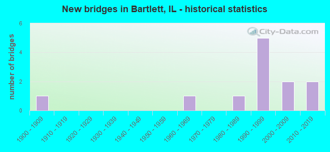
- New bridges - historical statistics
- 11900-1909
- 11960-1969
- 11980-1989
- 51990-1999
- 22000-2009
- 22010-2019
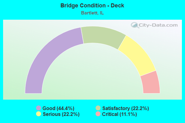
- Bridge Condition - Deck
- 44.4%Good
- 22.2%Satisfactory
- 22.2%Serious
- 11.1%Critical
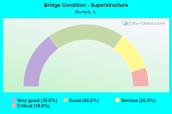
- Bridge Condition - Superstructure
- 30.0%Very good
- 40.0%Good
- 20.0%Serious
- 10.0%Critical
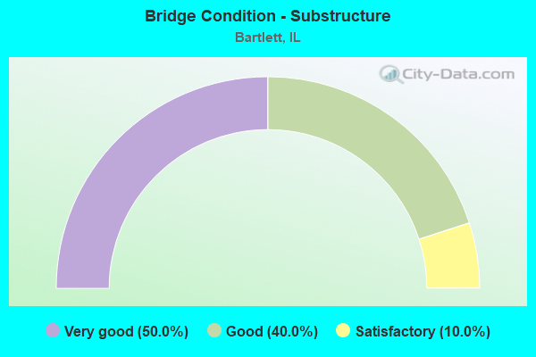
- Bridge Condition - Substructure
- 50.0%Very good
- 40.0%Good
- 10.0%Satisfactory
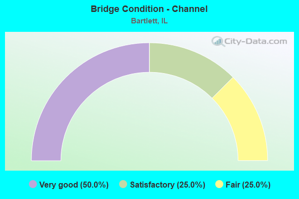
- Bridge Condition - Channel
- 50.0%Very good
- 25.0%Satisfactory
- 25.0%Fair
Find on map >> Show street view
Structure Number: 160254, Location: 0.8 M S OF IL 19 (Lat: 42.008175, Lng: -88.203311), Route carried "on" structure: US 20, Year Built: 1990, Status: Open, Structure Length: 5.57m (18.27ft), Average Daily Traffic: 35,900 (year 2021), Truck Traffic: 10%, Average Future Daily Traffic: 37,389 (year 2032), Design Load: HS 20, Features Intersected: IL 59 (SUTTON RD)
Minimum Vertical Clearance: 30+ m (98+ ft), Kilometerpoint: 239.721, Lanes on structure: 6, Lanes under structure: 4, Base Highway Network: Yes, Owner: State Highway Agency, Approaching Roadway Width: 26.8m (87.9ft), Skew: 32 degrees, Material/Design: Prestressed concrete continuous, Design/Construction: Stringer/Multi-beam, Number Of Spans In Main Unit: 3, Length of Maximum Span: 27.6m (90.6ft), Curb-To-Curb Width: 26.2m (86.0ft), Out-to-Out Width: 31.3m (102.7ft)
Condition: Deck: Good, Superstructure: Good, Substructure: Very good, Operating Rating: 83.3 metric tons, Method Used To Determine Operating Rating: Load Factor (LF) rating reported by rating factor (RF) method using MS18 loading, Inventory Rating: 49.9 metric tons, Method Used To Determine Inventory Rating: Load Factor (LF) rating reported by rating factor (RF) method using MS18 loading, Structural Evaluation: Better than present minimum criteria, Deck Geometry: Equal to present minimum criteria, Underclear: Meets minimum limits, Approach Roadway Alignment: Better than present minimum criteria, Designated Inspection Frequency: Every 24 months, Inspection Date: July 2021, Deck Structure Type: Concrete Cast-file-Place, Wearing Surface/Protective System: Wearing Surface: Epoxy Overlay, Deck Protection: Epoxy Coated Reinforcing
Find on map >> Show street view
Structure Number: 162606, Location: 0.8 M S US-20 (Lat: 41.997583, Lng: -88.205164), Route carried "on" structure: State highway 59, Year Built: 1993, Status: Open, Structure Length: 5.20m (17.06ft), Average Daily Traffic: 37,600 (year 2021), Truck Traffic: 9%, Average Future Daily Traffic: 42,333 (year 2032), Design Load: HS 20, Features Intersected: RR - METRA
Minimum Vertical Clearance: 30+ m (98+ ft), Kilometerpoint: 55.408, Lanes on structure: 4, Base Highway Network: Yes, Owner: State Highway Agency, Approaching Roadway Width: 20.7m (67.9ft), Skew: 30 degrees, Material/Design: Prestressed concrete continuous, Design/Construction: Stringer/Multi-beam, Number Of Spans In Main Unit: 3, Length of Maximum Span: 21.9m (71.9ft), Curb-To-Curb Width: 16.5m (54.1ft), Out-to-Out Width: 21.7m (71.2ft)
Condition: Deck: Satisfactory, Superstructure: Very good, Substructure: Good, Operating Rating: 71.3 metric tons, Method Used To Determine Operating Rating: Load Factor (LF) rating reported by rating factor (RF) method using MS18 loading, Inventory Rating: 44.1 metric tons, Method Used To Determine Inventory Rating: Load Factor (LF) rating reported by rating factor (RF) method using MS18 loading, Structural Evaluation: Better than present minimum criteria, Deck Geometry: Meets minimum limits, Underclear: Superior to present desirable criteria, Approach Roadway Alignment: Equal to present desirable criteria, Designated Inspection Frequency: Every 24 months, Inspection Date: March 2021, Deck Structure Type: Concrete Cast-file-Place, Wearing Surface/Protective System: Wearing Surface: Latex Concrete, Deck Protection: Epoxy Coated Reinforcing
Find on map >> Show street view
Structure Number: 223021, Location: 1.3 MI E. IL59 (Lat: 41.951383, Lng: -88.182603), Route carried "on" structure: Other road , Year Built: 1961, Year Reconstructed: 2009, Status: Open, Structure Length: 1.83m (6.00ft), Average Daily Traffic: 11,400 (year 2020), Truck Traffic: 2%, Average Future Daily Traffic: 16,710 (year 2032), Design Load: H 20, Features Intersected: W Br. DuPage River, Facility Carried by Structure: FAU-1369 (Schick R
Minimum Vertical Clearance: 30+ m (98+ ft), Kilometerpoint: 1.963, Lanes on structure: 2, Owner: City or Municipal Highway Agency, Approaching Roadway Width: 12.8m (42.0ft), Material/Design: Prestressed concrete, Design/Construction: Box Beam or Girders - Multiple, Number Of Spans In Main Unit: 2, Length of Maximum Span: 8.8m (28.9ft), Curb-To-Curb Width: 12.0m (39.4ft), Out-to-Out Width: 12.8m (42.0ft)
Condition: Deck: Critical, Superstructure: Critical, Substructure: Satisfactory, Channel: Fair, Operating Rating: 50.9 metric tons, Method Used To Determine Operating Rating: Load Factor (LF) rating reported by rating factor (RF) method using MS18 loading, Inventory Rating: 22.0 metric tons, Method Used To Determine Inventory Rating: Load Factor (LF) rating reported by rating factor (RF) method using MS18 loading, Structural Evaluation: High priority of replacement, Deck Geometry: Somewhat better than minimum adequacy, Waterway Adequacy: Equal to present minimum criteria, Approach Roadway Alignment: Equal to present desirable criteria, Designated Inspection Frequency: Every 24 months, Other Special Inspection Frequency: Every 6 months, Inspection Date: October 2021, Other Special Inspection Date: October 2021, Deck Structure Type: Concrete Precast Panels, Wearing Surface/Protective System: Wearing Surface: Bituminous, Membrane: Built-up
Find on map >> Show street view
Structure Number: 223094, Location: 1.6 MI E IL 59 (Lat: 41.943878, Lng: -88.181642), Route carried "on" structure: Other road , Year Built: 1987, Status: Open, Structure Length: 1.78m (5.84ft), Average Daily Traffic: 9,500 (year 2020), Truck Traffic: 9%, Average Future Daily Traffic: 29,100 (year 2035), Design Load: HS 20, Features Intersected: W BR DUPAGE RIVER, Facility Carried by Structure: FAP-367 (Army TR R
Minimum Vertical Clearance: 30+ m (98+ ft), Kilometerpoint: 2.253, Lanes on structure: 4, Base Highway Network: Yes, Owner: County Highway Agency, Approaching Roadway Width: 20.7m (67.9ft), Material/Design: Prestressed concrete, Design/Construction: Box Beam or Girders - Multiple, Number Of Spans In Main Unit: 1, Length of Maximum Span: 16.4m (53.8ft), Curb-To-Curb Width: 20.7m (67.9ft), Out-to-Out Width: 20.7m (67.9ft)
Condition: Deck: Serious, Superstructure: Serious, Substructure: Good, Channel: Satisfactory, Operating Rating: 42.4 metric tons, Method Used To Determine Operating Rating: Load Factor (LF) rating reported by rating factor (RF) method using MS18 loading, Inventory Rating: 21.1 metric tons, Method Used To Determine Inventory Rating: Load Factor (LF) rating reported by rating factor (RF) method using MS18 loading, Structural Evaluation: High priority of corrective action, Deck Geometry: Superior to present desirable criteria, Waterway Adequacy: Equal to present desirable criteria, Approach Roadway Alignment: Equal to present desirable criteria, Designated Inspection Frequency: Every 24 months, Inspection Date: August 2021, Deck Structure Type: Concrete Precast Panels, Wearing Surface/Protective System: Wearing Surface: Bituminous, Membrane: Built-up
Find on map >> Show street view
Structure Number: 226545, Location: 2.2M E OF IL-59 (Lat: 41.951686, Lng: -88.167036), Route carried "on" structure: Other road , Year Built: 1991, Status: Open, Structure Length: 3.20m (10.50ft), Average Daily Traffic: 11,400 (year 2020), Truck Traffic: 2%, Average Future Daily Traffic: 16,710 (year 2032), Design Load: HS 20+Mod, Features Intersected: I.C.RR, Facility Carried by Structure: SCHICK ROAD
Minimum Vertical Clearance: 30+ m (98+ ft), Kilometerpoint: 3.251, Lanes on structure: 2, Owner: City or Municipal Highway Agency, Approaching Roadway Width: 9.1m (29.9ft), Skew: 6 degrees, Material/Design: Prestressed concrete, Design/Construction: Stringer/Multi-beam, Number Of Spans In Main Unit: 1, Length of Maximum Span: 28.1m (92.2ft), Curb or Sidewalk Widths: Left: 0.0m, Right: 1.5m (4.9ft), Curb-To-Curb Width: 9.1m (29.9ft), Out-to-Out Width: 11.5m (37.7ft)
Condition: Deck: Satisfactory, Superstructure: Good, Substructure: Good, Operating Rating: 53.8 metric tons, Method Used To Determine Operating Rating: Assigned rating based on Load Factor Design (LFD) reported by rating factor (RF) using MS18 loading, Inventory Rating: 32.4 metric tons, Method Used To Determine Inventory Rating: Assigned rating based on Load Factor Design (LFD) reported by rating factor (RF) using MS18 loading, Structural Evaluation: Better than present minimum criteria, Deck Geometry: High priority of corrective action, Underclear: Somewhat better than minimum adequacy, Approach Roadway Alignment: Equal to present minimum criteria, Length Of Structure Improvement: 4.18m (13.71ft), Designated Inspection Frequency: Every 48 months, Inspection Date: August 2021, Bridge Improvement Cost: $417,000, Roadway Improvement Cost: $42,000, Total Project Cost: $626,000, Deck Structure Type: Concrete Cast-file-Place, Wearing Surface/Protective System: Deck Protection: Epoxy Coated Reinforcing
Find on map >> Show street view
Structure Number: 226546, Location: .1 MI E. BARTLETT RD (Lat: 41.961628, Lng: -88.184053), Route carried "on" structure: City street , Year Built: 1992, Status: Open, Structure Length: 1.28m (4.20ft), Average Daily Traffic: 1,650 (year 2020), Truck Traffic: 3%, Average Future Daily Traffic: 567 (year 2032), Design Load: HS 20, Features Intersected: W Br DuPage River, Facility Carried by Structure: MS-4410 StruckmanB
Minimum Vertical Clearance: 30+ m (98+ ft), Kilometerpoint: 0.129, Lanes on structure: 2, Owner: City or Municipal Highway Agency, Approaching Roadway Width: 10.4m (34.1ft), Material/Design: Prestressed concrete, Design/Construction: Box Beam or Girders - Multiple, Number Of Spans In Main Unit: 1, Length of Maximum Span: 12.0m (39.4ft), Curb or Sidewalk Widths: Left: 0.0m, Right: 2.4m (7.9ft), Curb-To-Curb Width: 10.4m (34.1ft), Out-to-Out Width: 13.4m (44.0ft)
Condition: Deck: Serious, Superstructure: Serious, Substructure: Good, Channel: Very good, Operating Rating: 64.5 metric tons, Method Used To Determine Operating Rating: Load Factor (LF) rating reported by rating factor (RF) method using MS18 loading, Inventory Rating: 38.6 metric tons, Method Used To Determine Inventory Rating: Load Factor (LF) rating reported by rating factor (RF) method using MS18 loading, Structural Evaluation: High priority of corrective action, Deck Geometry: Equal to present minimum criteria, Waterway Adequacy: Equal to present desirable criteria, Approach Roadway Alignment: Equal to present desirable criteria, Designated Inspection Frequency: Every 24 months, Inspection Date: October 2021, Deck Structure Type: Concrete Precast Panels, Wearing Surface/Protective System: Wearing Surface: Bituminous, Membrane: Built-up, Deck Protection: Internally Sealed
Find on map >> Show street view
Structure Number: 452032, Location: 0.1 MI N. STEARNS RD (Lat: 41.980861, Lng: -88.269044), Route carried "on" structure: State highway 25, Year Built: 2009, Status: Open, Structure Length: 4.33m (14.21ft), Average Daily Traffic: 13,100 (year 2021), Truck Traffic: 15%, Average Future Daily Traffic: 15,822 (year 2032), Design Load: HS 25 or greater, Features Intersected: E BR BREWSTER CREEK
Minimum Vertical Clearance: 30+ m (98+ ft), Kilometerpoint: 37.207, Lanes on structure: 4, Base Highway Network: Yes, Owner: State Highway Agency, Approaching Roadway Width: 28.8m (94.5ft), Skew: 30 degrees, Material/Design: Prestressed concrete continuous, Design/Construction: Stringer/Multi-beam, Number Of Spans In Main Unit: 3, Length of Maximum Span: 18.3m (60.0ft), Curb-To-Curb Width: 28.8m (94.5ft), Out-to-Out Width: 30.4m (99.7ft)
Condition: Deck: Good, Superstructure: Very good, Substructure: Very good, Channel: Very good, Operating Rating: 67.7 metric tons, Method Used To Determine Operating Rating: Load and Resistance Factor Rating (LRFR) rating reported by rating factor(RF) method using HL-93 loadings, Inventory Rating: 50.5 metric tons, Method Used To Determine Inventory Rating: Load and Resistance Factor Rating (LRFR) rating reported by rating factor(RF) method using HL-93 loadings, Structural Evaluation: Equal to present desirable criteria, Deck Geometry: Superior to present desirable criteria, Waterway Adequacy: Equal to present desirable criteria, Approach Roadway Alignment: Equal to present desirable criteria, Designated Inspection Frequency: Every 48 months, Inspection Date: August 2019, Deck Structure Type: Concrete Cast-file-Place, Wearing Surface/Protective System: Deck Protection: Epoxy Coated Reinforcing
Find on map >> Show street view
Structure Number: 45317, Location: .10M S OF STEARNS RD (Lat: 41.977558, Lng: -88.269069), Route carried "on" structure: Other road , Year Built: 2010, Status: Open, Structure Length: 6.30m (20.67ft), Average Daily Traffic: 16,500 (year 2018), Truck Traffic: 9%, Average Future Daily Traffic: 30,241 (year 2032), Design Load: HS 20, Features Intersected: CC&P RR, Facility Carried by Structure: DUNHAM RD SB
Minimum Vertical Clearance: 30+ m (98+ ft), Kilometerpoint: 19.955, Lanes on structure: 2, Base Highway Network: Yes, Owner: County Highway Agency, Approaching Roadway Width: 8.5m (27.9ft), Skew: 2 degrees, Material/Design: Steel continuous, Design/Construction: Stringer/Multi-beam, Number Of Spans In Main Unit: 3, Length of Maximum Span: 27.4m (89.9ft), Curb-To-Curb Width: 8.5m (27.9ft), Out-to-Out Width: 9.5m (31.2ft)
Condition: Deck: Good, Superstructure: Good, Substructure: Very good, Operating Rating: 78.7 metric tons, Method Used To Determine Operating Rating: Load Factor (LF) rating reported by rating factor (RF) method using MS18 loading, Inventory Rating: 41.5 metric tons, Method Used To Determine Inventory Rating: Load Factor (LF) rating reported by rating factor (RF) method using MS18 loading, Structural Evaluation: Better than present minimum criteria, Deck Geometry: High priority of corrective action, Underclear: Equal to present desirable criteria, Approach Roadway Alignment: Equal to present desirable criteria, Designated Inspection Frequency: Every 48 months, Inspection Date: August 2020, Deck Structure Type: Concrete Cast-file-Place, Wearing Surface/Protective System: Deck Protection: Epoxy Coated Reinforcing
Find on map >> Show street view
Structure Number: 453173, Location: 0.1MI E DUNHAM RD. (Lat: 41.977808, Lng: -88.268333), Route carried "on" structure: Other road , Year Built: 2010, Status: Open, Structure Length: 1.00m (3.28ft), Average Daily Traffic: 18,600 (year 2018), Truck Traffic: 6%, Average Future Daily Traffic: 10,208 (year 2032), Design Load: HS 20, Features Intersected: MULTIUSE PATH, Facility Carried by Structure: STEARNS ROAD
Minimum Vertical Clearance: 30+ m (98+ ft), Kilometerpoint: 0.064, Lanes on structure: 4, Base Highway Network: Yes, Owner: County Highway Agency, Approaching Roadway Width: 28.8m (94.5ft), Skew: 30 degrees, Material/Design: Concrete, Design/Construction: Frame, Number Of Spans In Main Unit: 1, Length of Maximum Span: 9.5m (31.2ft), Curb-To-Curb Width: 28.8m (94.5ft), Out-to-Out Width: 38.7m (127.0ft)
Condition: Superstructure: Very good, Substructure: Very good, Operating Rating: 84.6 metric tons, Method Used To Determine Operating Rating: Load Factor (LF) rating reported by rating factor (RF) method using MS18 loading, Inventory Rating: 50.5 metric tons, Method Used To Determine Inventory Rating: Load Factor (LF) rating reported by rating factor (RF) method using MS18 loading, Structural Evaluation: Equal to present desirable criteria, Deck Geometry: Superior to present desirable criteria, Approach Roadway Alignment: Equal to present desirable criteria, Designated Inspection Frequency: Every 48 months, Inspection Date: May 2020, Deck Structure Type: Concrete Cast-file-Place, Wearing Surface/Protective System: Deck Protection: Epoxy Coated Reinforcing
Find on map >> Show street view
Structure Number: 453174, Location: 0.01 M N STERNS RD (Lat: 41.980242, Lng: -88.269208), Route carried "on" structure: State highway 25, Year Built: 2009, Status: Open, Structure Length: 1.00m (3.28ft), Average Daily Traffic: 13,100 (year 2021), Truck Traffic: 15%, Average Future Daily Traffic: 15,822 (year 2032), Design Load: HS 20, Features Intersected: BIKE PATH
Minimum Vertical Clearance: 30+ m (98+ ft), Kilometerpoint: 37.127, Lanes on structure: 2, Base Highway Network: Yes, Owner: County Highway Agency, Approaching Roadway Width: 22.9m (75.1ft), Skew: 30 degrees, Material/Design: Concrete, Design/Construction: Slab, Number Of Spans In Main Unit: 1, Length of Maximum Span: 9.1m (29.9ft), Curb-To-Curb Width: 22.9m (75.1ft), Out-to-Out Width: 66.4m (217.8ft)
Condition: Deck: Good, Superstructure: Good, Substructure: Very good, Operating Rating: 77.8 metric tons, Method Used To Determine Operating Rating: Load Factor (LF) rating reported by rating factor (RF) method using MS18 loading, Inventory Rating: 46.7 metric tons, Method Used To Determine Inventory Rating: Load Factor (LF) rating reported by rating factor (RF) method using MS18 loading, Structural Evaluation: Better than present minimum criteria, Deck Geometry: Superior to present desirable criteria, Approach Roadway Alignment: Equal to present desirable criteria, Designated Inspection Frequency: Every 48 months, Inspection Date: September 2019, Deck Structure Type: Concrete Cast-file-Place, Wearing Surface/Protective System: Membrane: Other, Deck Protection: Epoxy Coated Reinforcing
Find on map >> Show street view
Structure Number: 160254, Location: 0.8 M S OF IL 19 (Lat: 42.008175, Lng: -88.203311), Route carried "under" structure: State highway 59, Year Built: 1990, Structure Length: 0. m, Average Daily Traffic: 37,600 (year 2021), Truck Traffic: 9%, Features Intersected: IL 59 (SUTTON RD), Facility Carried by Structure: US 20 (LAKE ST)
Minimum Vertical Clearance: 5.08m (16.67ft), Kilometerpoint: 56.631, Lanes on structure: 6, Lanes under structure: 4, Material/Design: Prestressed concrete continuous, Design/Construction: Stringer/Multi-beam, Length of Maximum Span: 27.6m (90.6ft)
Find on map >> Show street view
Structure Number: 229947, Location: 2 M S OF COOK CO. (Lat: 41.956647, Lng: -88.184442), Route carried "under" structure: Other road , Year Built: 1900, Structure Length: 0. m, Average Daily Traffic: 4,450 (year 2020), Truck Traffic: 3%, Features Intersected: BARTLETT ROAD, Facility Carried by Structure: CHGO.CENTRAL R.R.
Minimum Vertical Clearance: 4.72m (15.49ft), Kilometerpoint: 3.508, Lanes under structure: 2, Material/Design: Steel, Design/Construction: Truss - Deck, Length of Maximum Span: 15.2m (49.9ft)