Bridge Statistics for Batavia, New York (NY)
Condition, Traffic, Stress, Structural Evaluation, Project Costs
- National Bridge Inventory (NBI) Statistics
- 28Number of bridges
- 262ft / 80.1mTotal length
- $44,540,000Total costs
- 244,523Total average daily traffic
- 4,632Total average daily truck traffic
- National Bridge Inventory (NBI) Registered Bridges for Batavia
- No street view available for this location
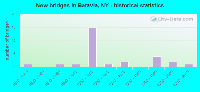
- New bridges - historical statistics
- 11910-1919
- 11930-1939
- 11940-1949
- 151950-1959
- 11960-1969
- 21970-1979
- 41990-1999
- 22000-2009
- 12010-2019

- Reconstructed bridges - Historical Statistics
- 21970-1979
- 31980-1989
- 11990-1999
- 12000-2009
- 12010-2019


- Bridge Condition - Deck
- 13.3%Excellent
- 13.3%Very good
- 6.7%Good
- 40.0%Satisfactory
- 20.0%Fair
- 6.7%Serious

- Bridge Condition - Superstructure
- 13.3%Excellent
- 13.3%Very good
- 20.0%Good
- 33.3%Satisfactory
- 6.7%Fair
- 13.3%Poor

- Bridge Condition - Substructure
- 6.7%Excellent
- 6.7%Very good
- 20.0%Good
- 20.0%Satisfactory
- 40.0%Fair
- 6.7%Poor

- Bridge Condition - Channel
- 20.0%Very good
- 30.0%Satisfactory
- 40.0%Fair
- 10.0%Poor

- Bridge Condition - Culverts
- 50.0%Fair
- 50.0%Poor
Find on map >> Show street view
Structure Number: 100169, Location: 3 MI W JCT RTS 5+63 BATV. (Lat: 43.001508, Lng: -78.259603), Route carried "on" structure: State highway 5, Year Built: 2016, Status: Open, Structure Length: 5.03m (16.50ft), Average Daily Traffic: 7,493 (year 2019), Truck Traffic: 6%, Average Future Daily Traffic: 9,102 (year 2040), Design Load: HL 93, Features Intersected: TONAWANDA CREEK
Minimum Vertical Clearance: 32.69m (107.25ft), Kilometerpoint: 16.895, Lanes on structure: 2, Base Highway Network: Yes, Owner: State Highway Agency, Approaching Roadway Width: 12.2m (40.0ft), Skew: 2 degrees, Material/Design: Steel, Design/Construction: Stringer/Multi-beam, Number Of Spans In Main Unit: 1, Length of Maximum Span: 48.8m (160.1ft), Curb-To-Curb Width: 12.2m (40.0ft), Out-to-Out Width: 13.2m (43.3ft)
Condition: Deck: Excellent, Superstructure: Excellent, Substructure: Excellent, Channel: Very good, Inventory Rating: 66.2 metric tons, Method Used To Determine Inventory Rating: Load Factor (LF), Structural Evaluation: Superior to present desirable criteria, Deck Geometry: Somewhat better than minimum adequacy, Waterway Adequacy: Somewhat better than minimum adequacy, Approach Roadway Alignment: Equal to present desirable criteria, Length Of Structure Improvement: 5.02m (16.47ft), Designated Inspection Frequency: Every 24 months, Inspection Date: August 2020, Bridge Improvement Cost: $2,408,000, Roadway Improvement Cost: $1,410,000, Total Project Cost: $3,818,000 ( Estimate for 2021), Deck Structure Type: Concrete Cast-file-Place, Wearing Surface/Protective System: Wearing Surface: Integral Concrete, Deck Protection: Epoxy Coated Reinforcing
Find on map >> Show street view
Structure Number: 10017, Location: .8 MI E JCT SH 5 & SH 33 (Lat: 42.992603, Lng: -78.149392), Route carried "on" structure: State highway 5, Year Built: 1955, Year Reconstructed: 1994, Status: Open, Structure Length: 3.47m (11.38ft), Average Daily Traffic: 7,669 (year 2018), Truck Traffic: 5%, Average Future Daily Traffic: 7,716 (year 2040), Design Load: HS 25 or greater, Features Intersected: CSX TRANS/AMTRAK
Minimum Vertical Clearance: 30+ m (98+ ft), Kilometerpoint: 26.339, Lanes on structure: 4, Base Highway Network: Yes, Owner: State Highway Agency, Approaching Roadway Width: 18.3m (60.0ft), Skew: 24 degrees, Material/Design: Steel, Design/Construction: Stringer/Multi-beam, Number Of Spans In Main Unit: 1, Length of Maximum Span: 33.2m (108.9ft), Curb-To-Curb Width: 19.7m (64.6ft), Out-to-Out Width: 20.5m (67.3ft)
Condition: Deck: Very good, Superstructure: Good, Substructure: Poor, Operating Rating: 83.5 metric tons, Method Used To Determine Operating Rating: Load Factor (LF), Inventory Rating: 40.8 metric tons, Method Used To Determine Inventory Rating: Load Factor (LF), Structural Evaluation: Meets minimum limits, Deck Geometry: Better than present minimum criteria, Underclear: Equal to present minimum criteria, Approach Roadway Alignment: Equal to present desirable criteria, Length Of Structure Improvement: 3.47m (11.38ft), Designated Inspection Frequency: Every 24 months, Inspection Date: October 2020, Bridge Improvement Cost: $3,530,000, Roadway Improvement Cost: $2,067,000, Total Project Cost: $5,597,000 ( Estimate for 2021), Deck Structure Type: Concrete Cast-file-Place, Wearing Surface/Protective System: Wearing Surface: Integral Concrete, Deck Protection: Epoxy Coated Reinforcing
Find on map >> Show street view
Structure Number: 1022969, Location: JCT RTE 98 + TONAWANDA CK (Lat: 42.999467, Lng: -78.192369), Route carried "on" structure: City street 33, Year Built: 1952, Status: Open, Structure Length: 4.69m (15.39ft), Average Daily Traffic: 8,813 (year 2019), Truck Traffic: 9%, Average Future Daily Traffic: 10,706 (year 2040), Design Load: HS 20+Mod, Features Intersected: TONAWANDA CREEK
Minimum Vertical Clearance: 30+ m (98+ ft), Kilometerpoint: 22.960, Lanes on structure: 3, Base Highway Network: Yes, Owner: State Highway Agency, Approaching Roadway Width: 16.5m (54.1ft), Skew: 21 degrees, Material/Design: Steel, Design/Construction: Stringer/Multi-beam, Number Of Spans In Main Unit: 3, Length of Maximum Span: 21.0m (68.9ft), Curb or Sidewalk Widths: Left: 2.5m (8.2ft), Right: 2.5m (8.2ft), Curb-To-Curb Width: 16.5m (54.1ft), Out-to-Out Width: 22.0m (72.2ft)
Condition: Deck: Satisfactory, Superstructure: Poor, Substructure: Fair, Channel: Satisfactory, Operating Rating: 98.0 metric tons, Method Used To Determine Operating Rating: Load Factor (LF), Inventory Rating: 59.0 metric tons, Method Used To Determine Inventory Rating: Load Factor (LF), Structural Evaluation: Meets minimum limits, Deck Geometry: Better than present minimum criteria, Waterway Adequacy: Somewhat better than minimum adequacy, Approach Roadway Alignment: Equal to present desirable criteria, Length Of Structure Improvement: 4.69m (15.39ft), Designated Inspection Frequency: Every 24 months, Inspection Date: November 2021, Bridge Improvement Cost: $2,573,000, Roadway Improvement Cost: $1,507,000, Total Project Cost: $4,080,000 ( Estimate for 2021), Deck Structure Type: Concrete Cast-file-Place, Wearing Surface/Protective System: Wearing Surface: Monolithic Concrete
Find on map >> Show street view
Structure Number: 102873, Location: JCT RT 63 + NYS THRUWAY (Lat: 43.017833, Lng: -78.218456), Route carried "on" structure: State highway 63, Year Built: 2001, Status: Open, Structure Length: 10.73m (35.20ft), Average Daily Traffic: 5,967 (year 2020), Truck Traffic: 7%, Average Future Daily Traffic: 6,003 (year 2040), Design Load: HS 25 or greater, Features Intersected: 90IX, RTE I90
Minimum Vertical Clearance: 30+ m (98+ ft), Kilometerpoint: 24.312, Lanes on structure: 2, Lanes under structure: 4, Base Highway Network: Yes, Owner: State Toll Authority, Approaching Roadway Width: 12.5m (41.0ft), Skew: 3 degrees, Material/Design: Steel continuous, Design/Construction: Stringer/Multi-beam, Number Of Spans In Main Unit: 2, Length of Maximum Span: 53.3m (174.9ft), Curb-To-Curb Width: 12.6m (41.3ft), Out-to-Out Width: 13.5m (44.3ft)
Condition: Deck: Very good, Superstructure: Very good, Substructure: Good, Operating Rating: 78.9 metric tons, Method Used To Determine Operating Rating: Load Factor (LF), Inventory Rating: 47.2 metric tons, Method Used To Determine Inventory Rating: Load Factor (LF), Structural Evaluation: Better than present minimum criteria, Deck Geometry: Somewhat better than minimum adequacy, Underclear: High priority of corrective action, Approach Roadway Alignment: Equal to present desirable criteria, Length Of Structure Improvement: 10.72m (35.17ft), Designated Inspection Frequency: Every 24 months, Inspection Date: October 2020, Bridge Improvement Cost: $3,411,000, Roadway Improvement Cost: $1,997,000, Total Project Cost: $5,408,000 ( Estimate for 2021), Deck Structure Type: Concrete Cast-file-Place, Wearing Surface/Protective System: Wearing Surface: Integral Concrete, Deck Protection: Galvanized Reinforcing
Find on map >> Show street view
Structure Number: 103573, Location: JCT S.H.98 & I90 (Lat: 43.018169, Lng: -78.192161), Route carried "on" structure: State highway 98, Year Built: 1991, Status: Open, Structure Length: 7.92m (25.98ft), Average Daily Traffic: 8,669 (year 2019), Truck Traffic: 10%, Average Future Daily Traffic: 10,531 (year 2040), Design Load: HS 20, Features Intersected: 90IX EB, RTE I90
Minimum Vertical Clearance: 30+ m (98+ ft), Kilometerpoint: 19.228, Lanes on structure: 2, Lanes under structure: 4, Base Highway Network: Yes, Owner: State Toll Authority, Approaching Roadway Width: 13.4m (44.0ft), Material/Design: Steel continuous, Design/Construction: Stringer/Multi-beam, Number Of Spans In Main Unit: 2, Length of Maximum Span: 39.0m (128.0ft), Curb-To-Curb Width: 13.2m (43.3ft), Out-to-Out Width: 14.2m (46.6ft)
Condition: Deck: Satisfactory, Superstructure: Good, Substructure: Good, Operating Rating: 74.4 metric tons, Method Used To Determine Operating Rating: Load Factor (LF), Inventory Rating: 43.5 metric tons, Method Used To Determine Inventory Rating: Load Factor (LF), Structural Evaluation: Better than present minimum criteria, Deck Geometry: Somewhat better than minimum adequacy, Underclear: Equal to present minimum criteria, Approach Roadway Alignment: Equal to present desirable criteria, Length Of Structure Improvement: 7.92m (25.98ft), Designated Inspection Frequency: Every 24 months, Inspection Date: April 2021, Bridge Improvement Cost: $2,810,000, Roadway Improvement Cost: $1,645,000, Total Project Cost: $4,455,000 ( Estimate for 2021), Deck Structure Type: Concrete Cast-file-Place, Wearing Surface/Protective System: Wearing Surface: Integral Concrete, Deck Protection: Epoxy Coated Reinforcing
Find on map >> Show street view
Structure Number: 221081, Location: AT CITY BATAVIA (Lat: 43.004014, Lng: -78.203417), Route carried "on" structure: City street , Year Built: 1975, Year Reconstructed: 2017, Status: Open, Structure Length: 4.42m (14.50ft), Average Daily Traffic: 4,190 (year 2019), Truck Traffic: 3%, Average Future Daily Traffic: 5,184 (year 2040), Design Load: HL 93, Features Intersected: TONAWANDA CREEK, Facility Carried by Structure: RIVER STREET
Minimum Vertical Clearance: 30+ m (98+ ft), Kilometerpoint: 1.110, Lanes on structure: 2, Owner: City or Municipal Highway Agency, Maintenance Responsibility: County Highway Agency, Approaching Roadway Width: 10.4m (34.1ft), Skew: 3 degrees, Material/Design: Prestressed concrete, Design/Construction: Box Beam or Girders - Multiple, Number Of Spans In Main Unit: 2, Length of Maximum Span: 21.0m (68.9ft), Curb or Sidewalk Widths: Left: 0.0m, Right: 1.6m (5.2ft), Curb-To-Curb Width: 10.4m (34.1ft), Out-to-Out Width: 13.2m (43.3ft)
Condition: Deck: Excellent, Superstructure: Excellent, Substructure: Very good, Channel: Very good, Inventory Rating: 57.2 metric tons, Method Used To Determine Inventory Rating: Load Factor (LF), Structural Evaluation: Equal to present desirable criteria, Deck Geometry: Somewhat better than minimum adequacy, Waterway Adequacy: Somewhat better than minimum adequacy, Approach Roadway Alignment: Equal to present desirable criteria, Length Of Structure Improvement: 4.41m (14.47ft), Designated Inspection Frequency: Every 24 months, Inspection Date: October 2021, Bridge Improvement Cost: $1,483,000, Roadway Improvement Cost: $868,000, Total Project Cost: $2,351,000 ( Estimate for 2021), Deck Structure Type: Concrete Cast-file-Place, Wearing Surface/Protective System: Wearing Surface: Integral Concrete, Deck Protection: Epoxy Coated Reinforcing
Find on map >> Show street view
Structure Number: 221082, Location: AT CITY BATAVIA (Lat: 43.000167, Lng: -78.197550), Route carried "on" structure: City street , Year Built: 1910, Year Reconstructed: 1986, Status: Closed, Structure Length: 4.08m (13.39ft), Average Daily Traffic: 1,437 (year 2019), Truck Traffic: 1%, Average Future Daily Traffic: 2,012 (year 2039), Features Intersected: TONAWANDA CREEK, Facility Carried by Structure: SOUTH LYON STREET
Minimum Vertical Clearance: 30+ m (98+ ft), Kilometerpoint: 0.209, Lanes on structure: 1, Owner: City or Municipal Highway Agency, Maintenance Responsibility: County Highway Agency, Approaching Roadway Width: 4.0m (13.1ft), Material/Design: Steel, Design/Construction: Truss - Thru, Number Of Spans In Main Unit: 1, Length of Maximum Span: 40.2m (131.9ft), Curb or Sidewalk Widths: Left: 1.5m (4.9ft), Right: 0.0m, Curb-To-Curb Width: 4.0m (13.1ft), Out-to-Out Width: 4.7m (15.4ft)
Condition: Deck: Serious, Superstructure: Satisfactory, Substructure: Fair, Channel: Fair, Waterway Adequacy: Equal to present desirable criteria, Approach Roadway Alignment: High priority of replacement, Bridge Posting: Required (Relationship of Operating Rating to Maximum Legal Load: > 39.9% below), Length Of Structure Improvement: 4.08m (13.39ft), Designated Inspection Frequency: Every 24 months, Critical Feature Inspection Frequency: Every 12 months, Inspection Date: August 2021, Critical Feature Inspection Date: August 2021, Bridge Improvement Cost: $1,657,000, Roadway Improvement Cost: $970,000, Total Project Cost: $2,627,000 ( Estimate for 2021), Deck Structure Type: Steel plate, Wearing Surface/Protective System: Wearing Surface: Other
Find on map >> Show street view
Structure Number: 221084, Location: AT CITY BATAVIA (Lat: 42.989758, Lng: -78.188181), Route carried "on" structure: City street , Year Built: 1975, Year Reconstructed: 2007, Status: Open, Structure Length: 3.78m (12.40ft), Average Daily Traffic: 3,556 (year 2017), Truck Traffic: 4%, Average Future Daily Traffic: 4,399 (year 2040), Design Load: HS 20, Features Intersected: TONAWANDA CREEK, Facility Carried by Structure: LAW STREET
Minimum Vertical Clearance: 30+ m (98+ ft), Kilometerpoint: 0.628, Lanes on structure: 2, Owner: City or Municipal Highway Agency, Maintenance Responsibility: County Highway Agency, Approaching Roadway Width: 7.9m (25.9ft), Skew: 1 degrees, Material/Design: Prestressed concrete, Design/Construction: Box Beam or Girders - Multiple, Number Of Spans In Main Unit: 2, Length of Maximum Span: 18.2m (59.7ft), Curb or Sidewalk Widths: Left: 1.7m (5.6ft), Right: 0.0m, Curb-To-Curb Width: 7.8m (25.6ft), Out-to-Out Width: 10.7m (35.1ft)
Condition: Deck: Good, Superstructure: Very good, Substructure: Satisfactory, Channel: Satisfactory, Inventory Rating: 61.7 metric tons, Method Used To Determine Inventory Rating: Load Factor (LF), Structural Evaluation: Equal to present minimum criteria, Deck Geometry: High priority of replacement, Waterway Adequacy: Equal to present minimum criteria, Approach Roadway Alignment: Equal to present desirable criteria, Length Of Structure Improvement: 3.77m (12.37ft), Designated Inspection Frequency: Every 24 months, Underwater Inspection Frequency: Every 60 months, Inspection Date: May 2021, Underwater Inspection Date: June 2018, Bridge Improvement Cost: $1,009,000, Roadway Improvement Cost: $591,000, Total Project Cost: $1,600,000 ( Estimate for 2021), Deck Structure Type: Concrete Cast-file-Place, Wearing Surface/Protective System: Wearing Surface: Monolithic Concrete, Deck Protection: Epoxy Coated Reinforcing
Find on map >> Show street view
Structure Number: 331565, Location: 2.7 MI SE E.PEMBROKE (Lat: 42.972017, Lng: -78.269419), Route carried "on" structure: Other road , Year Built: 1959, Status: Open, Structure Length: 1.49m (4.89ft), Average Daily Traffic: 195 (year 2019), Truck Traffic: 5%, Average Future Daily Traffic: 273 (year 2039), Design Load: H 20, Features Intersected: BOWEN CREEK, Facility Carried by Structure: ROSE ROAD
Minimum Vertical Clearance: 30+ m (98+ ft), Kilometerpoint: 0.837, Lanes on structure: 2, Owner: County Highway Agency, Approaching Roadway Width: 5.8m (19.0ft), Skew: 3 degrees, Material/Design: Steel, Design/Construction: Culvert, Number Of Spans In Main Unit: 3, Length of Maximum Span: 4.2m (13.8ft)
Condition: Channel: Poor, Culverts: Poor, Operating Rating: 71.8 metric tons, Method Used To Determine Operating Rating: Field evaluation and documented engineering judgment, Inventory Rating: 19.6 metric tons, Method Used To Determine Inventory Rating: Field evaluation and documented engineering judgment, Structural Evaluation: Meets minimum limits, Waterway Adequacy: Better than present minimum criteria, Approach Roadway Alignment: Equal to present desirable criteria, Length Of Structure Improvement: 1.49m (4.89ft), Designated Inspection Frequency: Every 24 months, Inspection Date: June 2021, Bridge Improvement Cost: $181,000, Roadway Improvement Cost: $106,000, Total Project Cost: $287,000 ( Estimate for 2021)
Find on map >> Show street view
Structure Number: 33157, Location: 3.7 MILES NE OF ALEXANDER (Lat: 42.948733, Lng: -78.220789), Route carried "on" structure: Other road , Year Built: 1969, Status: Open, Structure Length: 0.61m (2.00ft), Average Daily Traffic: 49 (year 2019), Truck Traffic: 5%, Average Future Daily Traffic: 69 (year 2039), Features Intersected: DRAINAGE DITCH, Facility Carried by Structure: COOKSON ROAD
Minimum Vertical Clearance: 30+ m (98+ ft), Kilometerpoint: 0.515, Lanes on structure: 2, Owner: County Highway Agency, Approaching Roadway Width: 5.5m (18.0ft), Skew: 1 degrees, Material/Design: Steel, Design/Construction: Culvert, Number Of Spans In Main Unit: 2, Length of Maximum Span: 2.7m (8.9ft)
Condition: Channel: Fair, Culverts: Fair, Operating Rating: 73.7 metric tons, Method Used To Determine Operating Rating: Field evaluation and documented engineering judgment, Inventory Rating: 19.6 metric tons, Method Used To Determine Inventory Rating: Field evaluation and documented engineering judgment, Structural Evaluation: Somewhat better than minimum adequacy, Waterway Adequacy: Better than present minimum criteria, Approach Roadway Alignment: Equal to present desirable criteria, Length Of Structure Improvement: 0.60m (1.97ft), Designated Inspection Frequency: Every 24 months, Inspection Date: June 2021, Bridge Improvement Cost: $60,000, Roadway Improvement Cost: $35,000, Total Project Cost: $95,000 ( Estimate for 2021)
Find on map >> Show street view
Structure Number: 331572, Location: 2.3 MI SOUTH OF BATAVIA (Lat: 42.966397, Lng: -78.191444), Route carried "on" structure: Other road , Year Built: 1951, Status: Open, Structure Length: 2.56m (8.40ft), Average Daily Traffic: 57 (year 2017), Truck Traffic: 10%, Average Future Daily Traffic: 80 (year 2037), Features Intersected: TONAWANDA CREEK, Facility Carried by Structure: DORMAN ROAD
Minimum Vertical Clearance: 30+ m (98+ ft), Kilometerpoint: 1.496, Lanes on structure: 2, Owner: County Highway Agency, Approaching Roadway Width: 5.2m (17.1ft), Material/Design: Steel, Design/Construction: Stringer/Multi-beam, Number Of Spans In Main Unit: 2, Length of Maximum Span: 12.1m (39.7ft), Curb or Sidewalk Widths: Left: 0.3m (1.0ft), Right: 0.3m (1.0ft), Curb-To-Curb Width: 6.1m (20.0ft), Out-to-Out Width: 7.0m (23.0ft)
Condition: Deck: Satisfactory, Superstructure: Satisfactory, Substructure: Fair, Channel: Fair, Operating Rating: 45.4 metric tons, Method Used To Determine Operating Rating: Load Factor (LF), Inventory Rating: 27.2 metric tons, Method Used To Determine Inventory Rating: Load Factor (LF), Structural Evaluation: Somewhat better than minimum adequacy, Deck Geometry: Somewhat better than minimum adequacy, Waterway Adequacy: Better than present minimum criteria, Approach Roadway Alignment: Equal to present desirable criteria, Length Of Structure Improvement: 2.56m (8.40ft), Designated Inspection Frequency: Every 24 months, Inspection Date: June 2021, Bridge Improvement Cost: $647,000, Roadway Improvement Cost: $379,000, Total Project Cost: $1,026,000 ( Estimate for 2021), Deck Structure Type: Concrete Cast-file-Place, Wearing Surface/Protective System: Wearing Surface: Bituminous
Find on map >> Show street view
Structure Number: 331574, Location: 3.7 MI SOUTH OF BATAVIA (Lat: 42.942417, Lng: -78.209767), Route carried "on" structure: Other road , Year Built: 1948, Year Reconstructed: 1996, Status: Open, Structure Length: 0.76m (2.49ft), Average Daily Traffic: 46 (year 2017), Truck Traffic: 5%, Average Future Daily Traffic: 64 (year 2037), Features Intersected: TRB TONAWANDA CRK, Facility Carried by Structure: OLD CREEK ROAD
Minimum Vertical Clearance: 30+ m (98+ ft), Kilometerpoint: 4.055, Lanes on structure: 2, Owner: County Highway Agency, Approaching Roadway Width: 6.4m (21.0ft), Material/Design: Steel, Design/Construction: Stringer/Multi-beam, Number Of Spans In Main Unit: 1, Length of Maximum Span: 7.3m (24.0ft), Curb-To-Curb Width: 6.9m (22.6ft), Out-to-Out Width: 8.1m (26.6ft)
Condition: Deck: Satisfactory, Superstructure: Fair, Substructure: Fair, Channel: Satisfactory, Operating Rating: 51.7 metric tons, Method Used To Determine Operating Rating: Load Factor (LF), Inventory Rating: 30.8 metric tons, Method Used To Determine Inventory Rating: Load Factor (LF), Structural Evaluation: Somewhat better than minimum adequacy, Deck Geometry: Somewhat better than minimum adequacy, Waterway Adequacy: Equal to present desirable criteria, Approach Roadway Alignment: Equal to present minimum criteria, Length Of Structure Improvement: 0.76m (2.49ft), Designated Inspection Frequency: Every 24 months, Inspection Date: April 2021, Bridge Improvement Cost: $274,000, Roadway Improvement Cost: $161,000, Total Project Cost: $435,000 ( Estimate for 2021), Deck Structure Type: Open Grating, Wearing Surface/Protective System: Wearing Surface: Other
Find on map >> Show street view
Structure Number: 331581, Location: 3.8 MI NE OF ALEXANDER (Lat: 42.929597, Lng: -78.192603), Route carried "on" structure: County highway , Year Built: 1933, Status: Open, Structure Length: 1.65m (5.41ft), Average Daily Traffic: 709 (year 2017), Truck Traffic: 6%, Average Future Daily Traffic: 993 (year 2037), Design Load: H 15, Features Intersected: LIT TONAWANDA CRK, Facility Carried by Structure: CREEK ROAD
Minimum Vertical Clearance: 30+ m (98+ ft), Kilometerpoint: 9.332, Lanes on structure: 2, Owner: County Highway Agency, Approaching Roadway Width: 6.7m (22.0ft), Material/Design: Steel, Design/Construction: Stringer/Multi-beam, Number Of Spans In Main Unit: 1, Length of Maximum Span: 16.1m (52.8ft), Curb-To-Curb Width: 7.9m (25.9ft), Out-to-Out Width: 8.5m (27.9ft)
Condition: Deck: Fair, Superstructure: Poor, Substructure: Fair, Channel: Fair, Operating Rating: 50.8 metric tons, Method Used To Determine Operating Rating: Load Factor (LF), Inventory Rating: 29.9 metric tons, Method Used To Determine Inventory Rating: Load Factor (LF), Structural Evaluation: Meets minimum limits, Deck Geometry: Somewhat better than minimum adequacy, Waterway Adequacy: Better than present minimum criteria, Approach Roadway Alignment: Equal to present desirable criteria, Length Of Structure Improvement: 1.64m (5.38ft), Designated Inspection Frequency: Every 24 months, Inspection Date: May 2021, Bridge Improvement Cost: $577,000, Roadway Improvement Cost: $338,000, Total Project Cost: $915,000 ( Estimate for 2021), Deck Structure Type: Concrete Cast-file-Place, Wearing Surface/Protective System: Wearing Surface: Bituminous
Find on map >> Show street view
Structure Number: 531566, Location: 2.5 MI W EXIT 48 OF I90 (Lat: 43.016644, Lng: -78.250492), Route carried "on" structure: Other road , Year Built: 1954, Year Reconstructed: 1983, Status: Open, Structure Length: 8.44m (27.69ft), Average Daily Traffic: 637 (year 2017), Truck Traffic: 3%, Average Future Daily Traffic: 892 (year 2037), Design Load: HS 20, Features Intersected: 90IX EB, RTE I90, Facility Carried by Structure: KELSEY RD
Minimum Vertical Clearance: 30+ m (98+ ft), Kilometerpoint: 0.434, Lanes on structure: 2, Lanes under structure: 4, Owner: State Toll Authority, Approaching Roadway Width: 9.4m (30.8ft), Material/Design: Steel, Design/Construction: Stringer/Multi-beam, Number Of Spans In Main Unit: 5, Length of Maximum Span: 20.1m (65.9ft), Curb-To-Curb Width: 9.4m (30.8ft), Out-to-Out Width: 10.1m (33.1ft)
Condition: Deck: Fair, Superstructure: Satisfactory, Substructure: Satisfactory, Operating Rating: 69.9 metric tons, Method Used To Determine Operating Rating: Load Factor (LF), Inventory Rating: 41.7 metric tons, Method Used To Determine Inventory Rating: Load Factor (LF), Structural Evaluation: Equal to present minimum criteria, Deck Geometry: Equal to present minimum criteria, Underclear: High priority of corrective action, Approach Roadway Alignment: Equal to present desirable criteria, Length Of Structure Improvement: 8.44m (27.69ft), Designated Inspection Frequency: Every 24 months, Inspection Date: April 2021, Bridge Improvement Cost: $1,919,000, Roadway Improvement Cost: $1,124,000, Total Project Cost: $3,043,000 ( Estimate for 2021), Deck Structure Type: Concrete Cast-file-Place, Wearing Surface/Protective System: Wearing Surface: Bituminous, Membrane: Other, Deck Protection: Epoxy Coated Reinforcing
Find on map >> Show street view
Structure Number: 531568, Location: 0.7 MI E. JCT RTE 98&I90 (Lat: 43.019142, Lng: -78.178392), Route carried "on" structure: ServiceCounty highway , Year Built: 1954, Year Reconstructed: 1987, Status: Open, Structure Length: 6.52m (21.39ft), Average Daily Traffic: 1,250 (year 2018), Truck Traffic: 9%, Average Future Daily Traffic: 1,546 (year 2040), Design Load: HS 20, Features Intersected: 90IX EB, RTE I90, Facility Carried by Structure: STATE STREET RD
Minimum Vertical Clearance: 30+ m (98+ ft), Kilometerpoint: 0.756, Lanes on structure: 2, Lanes under structure: 4, Owner: State Toll Authority, Approaching Roadway Width: 9.4m (30.8ft), Skew: 1 degrees, Material/Design: Steel, Design/Construction: Stringer/Multi-beam, Number Of Spans In Main Unit: 4, Length of Maximum Span: 19.8m (65.0ft), Curb-To-Curb Width: 9.4m (30.8ft), Out-to-Out Width: 10.1m (33.1ft)
Condition: Deck: Satisfactory, Superstructure: Satisfactory, Substructure: Fair, Operating Rating: 58.0 metric tons, Method Used To Determine Operating Rating: Load and Resistance Factor Rating (LRFR) rating reported by rating factor(RF) method using HL-93 loadings, Inventory Rating: 44.7 metric tons, Method Used To Determine Inventory Rating: Load and Resistance Factor Rating (LRFR) rating reported by rating factor(RF) method using HL-93 loadings, Structural Evaluation: Somewhat better than minimum adequacy, Deck Geometry: Somewhat better than minimum adequacy, Underclear: High priority of corrective action, Approach Roadway Alignment: Equal to present desirable criteria, Length Of Structure Improvement: 6.52m (21.39ft), Designated Inspection Frequency: Every 24 months, Inspection Date: April 2021, Bridge Improvement Cost: $1,533,000, Roadway Improvement Cost: $898,000, Total Project Cost: $2,430,000 ( Estimate for 2021), Deck Structure Type: Concrete Cast-file-Place, Wearing Surface/Protective System: Wearing Surface: Integral Concrete, Deck Protection: Epoxy Coated Reinforcing
Find on map >> Show street view
Structure Number: 531569, Location: 1.7 MI E RTE 98 < I90 (Lat: 43.020558, Lng: -78.158639), Route carried "on" structure: County highway , Year Built: 1954, Year Reconstructed: 1984, Status: Open, Structure Length: 7.16m (23.49ft), Average Daily Traffic: 2,486 (year 2019), Truck Traffic: 4%, Average Future Daily Traffic: 2,593 (year 2040), Design Load: HS 20+Mod, Features Intersected: 90IX EB, RTE I90, Facility Carried by Structure: CR 13 BANK STREET
Minimum Vertical Clearance: 30+ m (98+ ft), Kilometerpoint: 1.432, Lanes on structure: 2, Lanes under structure: 4, Owner: State Toll Authority, Approaching Roadway Width: 9.4m (30.8ft), Skew: 2 degrees, Material/Design: Steel, Design/Construction: Stringer/Multi-beam, Number Of Spans In Main Unit: 4, Length of Maximum Span: 21.6m (70.9ft), Curb-To-Curb Width: 9.4m (30.8ft), Out-to-Out Width: 10.1m (33.1ft)
Condition: Deck: Fair, Superstructure: Satisfactory, Substructure: Satisfactory, Operating Rating: 52.2 metric tons, Method Used To Determine Operating Rating: Load and Resistance Factor Rating (LRFR) rating reported by rating factor(RF) method using HL-93 loadings, Inventory Rating: 40.2 metric tons, Method Used To Determine Inventory Rating: Load and Resistance Factor Rating (LRFR) rating reported by rating factor(RF) method using HL-93 loadings, Structural Evaluation: Equal to present minimum criteria, Deck Geometry: Meets minimum limits, Underclear: High priority of corrective action, Approach Roadway Alignment: Equal to present desirable criteria, Length Of Structure Improvement: 7.16m (23.49ft), Designated Inspection Frequency: Every 24 months, Inspection Date: April 2021, Bridge Improvement Cost: $1,683,000, Roadway Improvement Cost: $985,000, Total Project Cost: $2,668,000 ( Estimate for 2021), Deck Structure Type: Concrete Cast-file-Place, Wearing Surface/Protective System: Wearing Surface: Bituminous, Membrane: Other, Deck Protection: Epoxy Coated Reinforcing
Find on map >> Show street view
Structure Number: 551683, Location: 0.4 MI E JCT RTE 98 & I90 (Lat: 43.018831, Lng: -78.186158), Route carried "on" structure: Ramp Interstate , Year Built: 1995, Status: Open, Structure Length: 6.80m (22.31ft), Average Daily Traffic: 3,016 (year 2019), Truck Traffic: 31%, Average Future Daily Traffic: 4,194 (year 2040), Design Load: HS 25 or greater, Features Intersected: 90IX EB, RTE I90, Facility Carried by Structure: 90IX EXIT 48 RAMP
Minimum Vertical Clearance: 30+ m (98+ ft), Kilometerpoint: 0.724, Lanes on structure: 2, Lanes under structure: 5, Toll: On Interstate toll segment, Owner: State Toll Authority, Approaching Roadway Width: 12.8m (42.0ft), Skew: 20 degrees, Material/Design: Steel continuous, Design/Construction: Stringer/Multi-beam, Number Of Spans In Main Unit: 2, Length of Maximum Span: 33.5m (109.9ft), Curb-To-Curb Width: 13.1m (43.0ft), Out-to-Out Width: 13.7m (44.9ft)
Condition: Deck: Satisfactory, Superstructure: Good, Substructure: Good, Operating Rating: 99.8 metric tons, Method Used To Determine Operating Rating: Load Factor (LF), Inventory Rating: 59.9 metric tons, Method Used To Determine Inventory Rating: Load Factor (LF), Structural Evaluation: Better than present minimum criteria, Deck Geometry: Superior to present desirable criteria, Underclear: High priority of corrective action, Approach Roadway Alignment: Equal to present desirable criteria, Length Of Structure Improvement: 6.79m (22.28ft), Designated Inspection Frequency: Every 24 months, Inspection Date: April 2021, Bridge Improvement Cost: $2,337,000, Roadway Improvement Cost: $1,368,000, Total Project Cost: $3,705,000 ( Estimate for 2021), Deck Structure Type: Concrete Cast-file-Place, Wearing Surface/Protective System: Wearing Surface: Bituminous, Membrane: Other, Deck Protection: Galvanized Reinforcing
Find on map >> Show street view
Structure Number: 102873, Location: JCT RT 63 + NYS THRUWAY (Lat: 43.017833, Lng: -78.218456), Route carried "under" structure: Interstate 90, Year Built: 2001, Structure Length: 0. m, Average Daily Traffic: 18,500 (year 1973), Features Intersected: 90IX, RTE I90, Facility Carried by Structure: RTE 63
Minimum Vertical Clearance: 4.67m (15.32ft), Kilometerpoint: 630.342, Lanes on structure: 2, Lanes under structure: 2, Toll: On Interstate toll segment, Material/Design: Steel continuous, Design/Construction: Stringer/Multi-beam, Length of Maximum Span: 53.3m (174.9ft)
Find on map >> Show street view
Structure Number: 103573, Location: JCT S.H.98 & I90 (Lat: 43.018169, Lng: -78.192161), Route carried "under" structure: Interstate 90, Year Built: 1991, Structure Length: 0. m, Average Daily Traffic: 29,000 (year 1990), Features Intersected: 90IX EB, RTE I90, Facility Carried by Structure: RTE 98
Minimum Vertical Clearance: 5.46m (17.91ft), Kilometerpoint: 628.202, Lanes on structure: 2, Lanes under structure: 2, Toll: On Interstate toll segment, Material/Design: Steel continuous, Design/Construction: Stringer/Multi-beam, Length of Maximum Span: 39.0m (128.0ft)
Find on map >> Show street view
Structure Number: 531566, Location: 2.5 MI W EXIT 48 OF I90 (Lat: 43.016644, Lng: -78.250492), Route carried "under" structure: Interstate 90, Year Built: 1954, Structure Length: 0. m, Average Daily Traffic: 14,500 (year 1975), Features Intersected: 90IX EB, RTE I90, Facility Carried by Structure: KELSEY RD
Minimum Vertical Clearance: 4.47m (14.67ft), Kilometerpoint: 632.965, Lanes on structure: 2, Lanes under structure: 2, Toll: On Interstate toll segment, Material/Design: Steel, Design/Construction: Stringer/Multi-beam, Length of Maximum Span: 20.1m (65.9ft)
Find on map >> Show street view
Structure Number: 531568, Location: 0.7 MI E. JCT RTE 98&I90 (Lat: 43.019142, Lng: -78.178392), Route carried "under" structure: Interstate 90, Year Built: 1954, Structure Length: 0. m, Average Daily Traffic: 16,840 (year 1977), Features Intersected: 90IX EB, RTE I90, Facility Carried by Structure: STATE STREET RD
Minimum Vertical Clearance: 4.65m (15.26ft), Kilometerpoint: 627.076, Lanes on structure: 2, Lanes under structure: 2, Toll: On Interstate toll segment, Material/Design: Steel, Design/Construction: Stringer/Multi-beam, Length of Maximum Span: 19.8m (65.0ft)
Find on map >> Show street view
Structure Number: 531569, Location: 1.7 MI E RTE 98 < I90 (Lat: 43.020558, Lng: -78.158639), Route carried "under" structure: Interstate 90, Year Built: 1954, Structure Length: 0. m, Average Daily Traffic: 16,840 (year 1977), Features Intersected: 90IX EB, RTE I90, Facility Carried by Structure: CR 13 BANK STREET
Minimum Vertical Clearance: 4.50m (14.76ft), Kilometerpoint: 625.467, Lanes on structure: 2, Lanes under structure: 2, Toll: On Interstate toll segment, Material/Design: Steel, Design/Construction: Stringer/Multi-beam, Length of Maximum Span: 21.6m (70.9ft)
Find on map >> Show street view
Structure Number: 551683, Location: 0.4 MI E JCT RTE 98 & I90 (Lat: 43.018831, Lng: -78.186158), Route carried "under" structure: Interstate 90, Year Built: 1995, Structure Length: 0. m, Average Daily Traffic: 16,840 (year 1977), Features Intersected: 90IX EB, RTE I90
Minimum Vertical Clearance: 4.52m (14.83ft), Kilometerpoint: 627.719, Lanes on structure: 2, Lanes under structure: 3, Toll: On Interstate toll segment, Material/Design: Steel continuous, Design/Construction: Stringer/Multi-beam, Length of Maximum Span: 33.5m (109.9ft)
Find on map >> Show street view
Structure Number: 7028771, Location: 1.2 MI SE JCT RTS 63 + 5 (Lat: 42.985439, Lng: -78.169047), Route carried "under" structure: Alternate State highway 63, Year Built: 1956, Structure Length: 0. m, Average Daily Traffic: 33,233 (year 1999), Features Intersected: RTE 63, Facility Carried by Structure: CSX TRANSPRTATION
Minimum Vertical Clearance: 4.41m (14.47ft), Kilometerpoint: 0.563, Lanes under structure: 4, Material/Design: Steel, Design/Construction: Girder and Floorbeam System, Length of Maximum Span: 23.1m (75.8ft)
Find on map >> Show street view
Structure Number: 7028772, Location: 1.3 MI SE JCT RTS 63 + 5 (Lat: 42.985375, Lng: -78.168950), Route carried "under" structure: Alternate State highway 63, Year Built: 1956, Structure Length: 0. m, Average Daily Traffic: 33,233 (year 1999), Features Intersected: RTE 63, Facility Carried by Structure: CSX TRANSPRTATION
Minimum Vertical Clearance: 5.02m (16.47ft), Kilometerpoint: 0.563, Lanes under structure: 4, Material/Design: Steel, Design/Construction: Girder and Floorbeam System, Length of Maximum Span: 22.5m (73.8ft)
Find on map >> Show street view
Structure Number: 70357, Location: 1.1 MI SW JCT RTS 98 + 63 (Lat: 42.985803, Lng: -78.200133), Route carried "under" structure: Alternate State highway 98, Year Built: 1956, Structure Length: 0. m, Average Daily Traffic: 5,869 (year 1999), Features Intersected: RTE 98, Facility Carried by Structure: CSX TRANSPRTATION
Minimum Vertical Clearance: 4.31m (14.14ft), Kilometerpoint: 15.286, Lanes under structure: 2, Material/Design: Steel, Design/Construction: Stringer/Multi-beam, Length of Maximum Span: 16.7m (54.8ft)
Find on map >> Show street view
Structure Number: 771413, Location: SE CORNER CITY BATAVIA (Lat: 42.987286, Lng: -78.163050), Route carried "under" structure: City street , Year Built: 1956, Structure Length: 0. m, Average Daily Traffic: 2,438 (year 2019), Truck Traffic: 7%, Features Intersected: CEDAR STREET, Facility Carried by Structure: CSX TRANSPRTATION
Minimum Vertical Clearance: 4.34m (14.24ft), Kilometerpoint: 0.547, Lanes under structure: 2, Material/Design: Steel, Design/Construction: Stringer/Multi-beam, Length of Maximum Span: 18.8m (61.7ft)
Find on map >> Show street view
Structure Number: 7714159, Location: SE COR.CITY OF BATAVIA (Lat: 42.985039, Lng: -78.171239), Route carried "under" structure: Other road , Year Built: 1956, Structure Length: 0. m, Average Daily Traffic: 991 (year 2019), Truck Traffic: 5%, Features Intersected: CO ROAD 1-CRK RD, Facility Carried by Structure: CSX TRANSPRTATION
Minimum Vertical Clearance: 4.31m (14.14ft), Kilometerpoint: 0.724, Lanes under structure: 2, Material/Design: Steel, Design/Construction: Stringer/Multi-beam, Length of Maximum Span: 11.8m (38.7ft)