Bridge Statistics for Bay Minette, Alabama (AL)
Condition, Traffic, Stress, Structural Evaluation, Project Costs
- National Bridge Inventory (NBI) Statistics
- 34Number of bridges
- 348ft / 106mTotal length
- $41,755,000Total costs
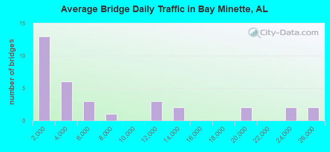
- 239,317Total average daily traffic
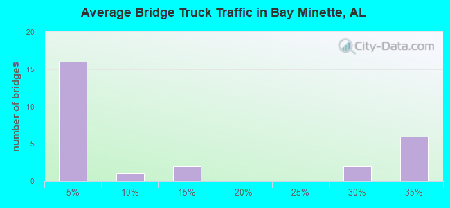
- 45,742Total average daily truck traffic
- National Bridge Inventory (NBI) Registered Bridges for Bay Minette
- No street view available for this location
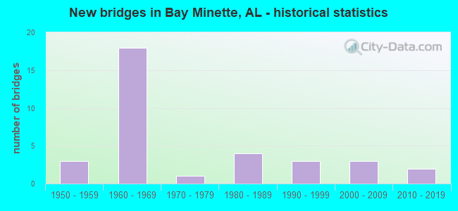
- New bridges - historical statistics
- 31950-1959
- 181960-1969
- 11970-1979
- 41980-1989
- 31990-1999
- 32000-2009
- 22010-2019
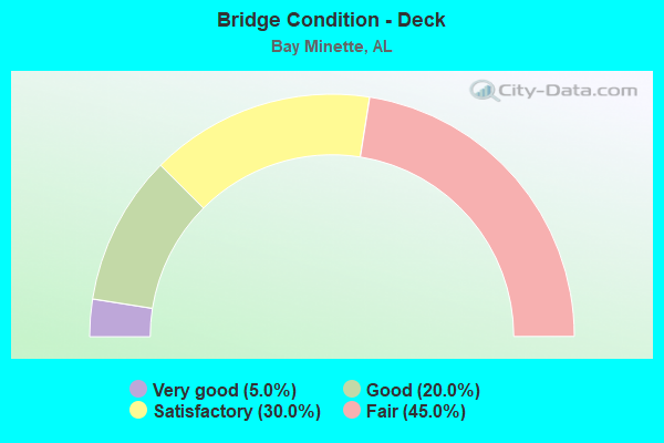
- Bridge Condition - Deck
- 5.0%Very good
- 20.0%Good
- 30.0%Satisfactory
- 45.0%Fair
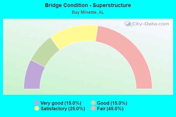
- Bridge Condition - Superstructure
- 15.0%Very good
- 15.0%Good
- 25.0%Satisfactory
- 45.0%Fair
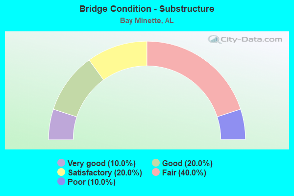
- Bridge Condition - Substructure
- 10.0%Very good
- 20.0%Good
- 20.0%Satisfactory
- 40.0%Fair
- 10.0%Poor
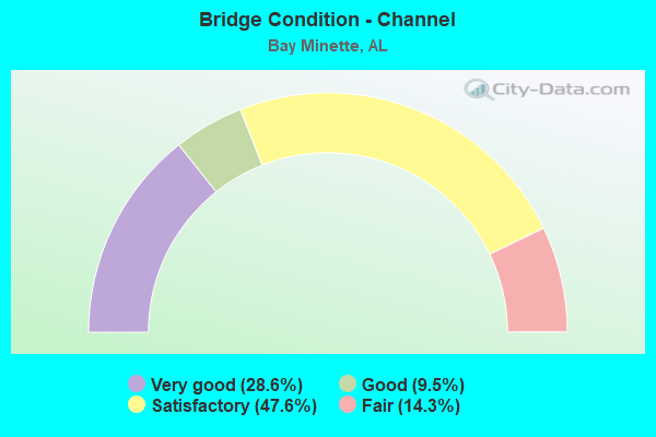
- Bridge Condition - Channel
- 28.6%Very good
- 9.5%Good
- 47.6%Satisfactory
- 14.3%Fair
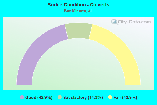
- Bridge Condition - Culverts
- 42.9%Good
- 14.3%Satisfactory
- 42.9%Fair
Find on map >> Show street view
Structure Number: 4001, Location: 3.5 MI N JCT SR 59 (Lat: 30.908942, Lng: -87.722933), Route carried "on" structure: US 31, Year Built: 1951, Status: Open, Structure Length: 4.15m (13.62ft), Average Daily Traffic: 4,242 (year 2019), Truck Traffic: 4%, Average Future Daily Traffic: 6,363 (year 2039), Design Load: HS 20, Features Intersected: MC CURTIN CREEK
Minimum Vertical Clearance: 30+ m (98+ ft), Kilometerpoint: 39.863, Lanes on structure: 2, Owner: State Highway Agency, Approaching Roadway Width: 8.5m (27.9ft), Material/Design: Concrete, Design/Construction: Tee Beam, Number Of Spans In Main Unit: 4, Length of Maximum Span: 10.4m (34.1ft), Curb-To-Curb Width: 8.5m (27.9ft), Out-to-Out Width: 10.2m (33.5ft)
Condition: Deck: Fair, Superstructure: Satisfactory, Substructure: Fair, Channel: Satisfactory, Operating Rating: 48.7 metric tons, Method Used To Determine Operating Rating: Load Factor (LF), Inventory Rating: 29.3 metric tons, Method Used To Determine Inventory Rating: Load Factor (LF), Structural Evaluation: Somewhat better than minimum adequacy, Deck Geometry: Meets minimum limits, Waterway Adequacy: Equal to present minimum criteria, Approach Roadway Alignment: Equal to present desirable criteria, Length Of Structure Improvement: 5.11m (16.77ft), Designated Inspection Frequency: Every 24 months, Underwater Inspection Frequency: Every 24 months, Inspection Date: April 2021, Underwater Inspection Date: May 2021, Bridge Improvement Cost: $1,156,000, Roadway Improvement Cost: $116,000, Total Project Cost: $1,272,000 ( Estimate for 2022), Deck Structure Type: Concrete Cast-file-Place
Find on map >> Show street view
Structure Number: 4171, Location: 1 MI N COUNTY ROAD 138 (Lat: 30.850483, Lng: -87.868142), Route carried "on" structure: State highway 225, Year Built: 1951, Status: Open, Structure Length: 0.94m (3.08ft), Average Daily Traffic: 3,313 (year 2020), Truck Traffic: 4%, Average Future Daily Traffic: 4,970 (year 2040), Design Load: HS 20, Features Intersected: STONEY RIDGE CREEK
Minimum Vertical Clearance: 30+ m (98+ ft), Kilometerpoint: 21.218, Lanes on structure: 2, Owner: State Highway Agency, Approaching Roadway Width: 8.1m (26.6ft), Material/Design: Concrete, Design/Construction: Culvert, Number Of Spans In Main Unit: 3, Length of Maximum Span: 3.0m (9.8ft)
Condition: Channel: Satisfactory, Culverts: Satisfactory, Operating Rating: 42.9 metric tons, Method Used To Determine Operating Rating: Load Factor (LF), Inventory Rating: 25.8 metric tons, Method Used To Determine Inventory Rating: Load Factor (LF), Structural Evaluation: Equal to present minimum criteria, Waterway Adequacy: Equal to present minimum criteria, Approach Roadway Alignment: Equal to present minimum criteria, Length Of Structure Improvement: 1.62m (5.31ft), Designated Inspection Frequency: Every 24 months, Underwater Inspection Frequency: Every 24 months, Inspection Date: October 2021, Underwater Inspection Date: October 2021, Bridge Improvement Cost: $262,000, Roadway Improvement Cost: $26,000, Total Project Cost: $288,000 ( Estimate for 2022)
Find on map >> Show street view
Structure Number: 5729, Location: 1.0 MI. S. OF S.R. 112 (Lat: 30.867703, Lng: -87.716972), Route carried "on" structure: County highway , Year Built: 1957, Status: Posted for load, Structure Length: 2.35m (7.71ft), Average Daily Traffic: 56 (year 2019), Average Future Daily Traffic: 76 (year 2039), Features Intersected: HOLLINGER CREEK, Facility Carried by Structure: STILL ROAD
Minimum Vertical Clearance: 30+ m (98+ ft), Kilometerpoint: 0.010, Lanes on structure: 2, Owner: County Highway Agency, Approaching Roadway Width: 9.1m (29.9ft), Material/Design: Wood or Timber, Design/Construction: Stringer/Multi-beam, Number Of Spans In Main Unit: 5, Length of Maximum Span: 4.6m (15.1ft), Curb-To-Curb Width: 6.6m (21.7ft), Out-to-Out Width: 7.2m (23.6ft)
Condition: Deck: Fair, Superstructure: Satisfactory, Substructure: Poor, Channel: Satisfactory, Operating Rating: 14.2 metric tons, Method Used To Determine Operating Rating: Allowable Stress (AS), Inventory Rating: 9.9 metric tons, Method Used To Determine Inventory Rating: Allowable Stress (AS), Structural Evaluation: High priority of replacement, Deck Geometry: Somewhat better than minimum adequacy, Waterway Adequacy: Equal to present minimum criteria, Approach Roadway Alignment: Equal to present desirable criteria, Bridge Posting: Required (Relationship of Operating Rating to Maximum Legal Load: 30.0 - 39.9% below), Length Of Structure Improvement: 3.19m (10.47ft), Designated Inspection Frequency: Every 24 months, Other Special Inspection Frequency: Every 12 months, Inspection Date: January 2022, Other Special Inspection Date: January 2022, Bridge Improvement Cost: $504,000, Roadway Improvement Cost: $50,000, Total Project Cost: $554,000 ( Estimate for 2022), Deck Structure Type: Concrete Cast-file-Place
Find on map >> Show street view
Structure Number: 856, Location: 1 MI N SR 287 (Lat: 30.969003, Lng: -87.742436), Route carried "on" structure: Interstate 65, Year Built: 1965, Status: Open, Structure Length: 1.43m (4.69ft), Average Daily Traffic: 19,401 (year 2019), Truck Traffic: 30%, Average Future Daily Traffic: 29,102 (year 2039), Design Load: HS 15, Features Intersected: WATERHOLE HOLLOW CREEK
Minimum Vertical Clearance: 30+ m (98+ ft), Kilometerpoint: 62.449, Lanes on structure: 4, Base Highway Network: Yes, Owner: State Highway Agency, Approaching Roadway Width: 24.4m (80.1ft), Skew: 13 degrees, Material/Design: Concrete, Design/Construction: Culvert, Number Of Spans In Main Unit: 4, Length of Maximum Span: 3.0m (9.8ft)
Condition: Channel: Fair, Culverts: Fair, Operating Rating: 88.9 metric tons, Method Used To Determine Operating Rating: Load Factor (LF), Inventory Rating: 88.9 metric tons, Method Used To Determine Inventory Rating: Load Factor (LF), Structural Evaluation: Somewhat better than minimum adequacy, Waterway Adequacy: Equal to present minimum criteria, Approach Roadway Alignment: Equal to present desirable criteria, Length Of Structure Improvement: 2.11m (6.92ft), Designated Inspection Frequency: Every 24 months, Inspection Date: December 2020, Bridge Improvement Cost: $3,045,000, Roadway Improvement Cost: $305,000, Total Project Cost: $3,350,000 ( Estimate for 2022)
Find on map >> Show street view
Structure Number: 8561, Location: 2 MI N SR 287 (Lat: 30.974175, Lng: -87.727283), Route carried "on" structure: Interstate 65, Year Built: 1965, Status: Open, Structure Length: 1.92m (6.30ft), Average Daily Traffic: 25,470 (year 2018), Truck Traffic: 30%, Average Future Daily Traffic: 38,205 (year 2038), Design Load: HS 20, Features Intersected: COW DEVIL CREEK
Minimum Vertical Clearance: 30+ m (98+ ft), Kilometerpoint: 63.999, Lanes on structure: 4, Base Highway Network: Yes, Owner: State Highway Agency, Approaching Roadway Width: 23.2m (76.1ft), Skew: 10 degrees, Material/Design: Concrete, Design/Construction: Culvert, Number Of Spans In Main Unit: 5, Length of Maximum Span: 3.7m (12.1ft)
Condition: Channel: Satisfactory, Culverts: Fair, Operating Rating: 85.0 metric tons, Method Used To Determine Operating Rating: Load Factor (LF), Inventory Rating: 50.9 metric tons, Method Used To Determine Inventory Rating: Load Factor (LF), Structural Evaluation: Somewhat better than minimum adequacy, Waterway Adequacy: Equal to present minimum criteria, Approach Roadway Alignment: Equal to present desirable criteria, Length Of Structure Improvement: 2.65m (8.69ft), Designated Inspection Frequency: Every 24 months, Inspection Date: July 2020, Bridge Improvement Cost: $2,221,000, Roadway Improvement Cost: $222,000, Total Project Cost: $2,443,000 ( Estimate for 2022)
Find on map >> Show street view
Structure Number: 8562, Location: 2.7 MI N SR 287 (Lat: 30.979178, Lng: -87.715328), Route carried "on" structure: Interstate 65, Year Built: 1965, Status: Open, Structure Length: 11.40m (37.40ft), Average Daily Traffic: 12,735 (year 2018), Truck Traffic: 30%, Average Future Daily Traffic: 19,103 (year 2038), Design Load: HS 20, Features Intersected: DYASS CREEK
Minimum Vertical Clearance: 30+ m (98+ ft), Kilometerpoint: 65.280, Lanes on structure: 2, Base Highway Network: Yes, Owner: State Highway Agency, Approaching Roadway Width: 12.2m (40.0ft), Skew: 10 degrees, Material/Design: Concrete, Design/Construction: Tee Beam, Number Of Spans In Main Unit: 11, Length of Maximum Span: 10.4m (34.1ft), Curb-To-Curb Width: 8.5m (27.9ft), Out-to-Out Width: 10.1m (33.1ft)
Condition: Deck: Fair, Superstructure: Fair, Substructure: Fair, Channel: Fair, Operating Rating: 47.4 metric tons, Method Used To Determine Operating Rating: Load Factor (LF), Inventory Rating: 28.5 metric tons, Method Used To Determine Inventory Rating: Load Factor (LF), Structural Evaluation: Somewhat better than minimum adequacy, Deck Geometry: High priority of corrective action, Waterway Adequacy: Better than present minimum criteria, Approach Roadway Alignment: Better than present minimum criteria, Length Of Structure Improvement: 12.27m (40.26ft), Designated Inspection Frequency: Every 24 months, Underwater Inspection Frequency: Every 24 months, Inspection Date: August 2020, Underwater Inspection Date: January 2022, Bridge Improvement Cost: $2,777,000, Roadway Improvement Cost: $278,000, Total Project Cost: $3,055,000 ( Estimate for 2022), Deck Structure Type: Concrete Cast-file-Place
Find on map >> Show street view
Structure Number: 8563, Location: 2.7 MI N SR 287 (Lat: 30.978989, Lng: -87.715189), Route carried "on" structure: Interstate 65, Year Built: 1965, Status: Open, Structure Length: 11.40m (37.40ft), Average Daily Traffic: 12,735 (year 2018), Truck Traffic: 30%, Average Future Daily Traffic: 19,103 (year 2038), Design Load: HS 20, Features Intersected: DYASS CREEK
Minimum Vertical Clearance: 30+ m (98+ ft), Kilometerpoint: 65.280, Lanes on structure: 2, Base Highway Network: Yes, Owner: State Highway Agency, Approaching Roadway Width: 12.2m (40.0ft), Skew: 10 degrees, Material/Design: Concrete, Design/Construction: Tee Beam, Number Of Spans In Main Unit: 11, Length of Maximum Span: 10.4m (34.1ft), Curb-To-Curb Width: 8.5m (27.9ft), Out-to-Out Width: 10.1m (33.1ft)
Condition: Deck: Satisfactory, Superstructure: Fair, Substructure: Fair, Channel: Satisfactory, Operating Rating: 47.4 metric tons, Method Used To Determine Operating Rating: Load Factor (LF), Inventory Rating: 28.5 metric tons, Method Used To Determine Inventory Rating: Load Factor (LF), Structural Evaluation: Somewhat better than minimum adequacy, Deck Geometry: High priority of corrective action, Waterway Adequacy: Equal to present desirable criteria, Approach Roadway Alignment: Better than present minimum criteria, Length Of Structure Improvement: 12.27m (40.26ft), Designated Inspection Frequency: Every 24 months, Underwater Inspection Frequency: Every 24 months, Inspection Date: August 2020, Underwater Inspection Date: January 2022, Bridge Improvement Cost: $2,777,000, Roadway Improvement Cost: $278,000, Total Project Cost: $3,055,000 ( Estimate for 2022), Deck Structure Type: Concrete Cast-file-Place
Find on map >> Show street view
Structure Number: 8919, Location: SR 287 @ I-65 (Lat: 30.964078, Lng: -87.759831), Route carried "on" structure: State highway 287, Year Built: 1965, Status: Open, Structure Length: 8.87m (29.10ft), Average Daily Traffic: 10,106 (year 2018), Truck Traffic: 3%, Average Future Daily Traffic: 15,159 (year 2038), Design Load: HS 20, Features Intersected: I-65 SB * NB
Minimum Vertical Clearance: 30+ m (98+ ft), Kilometerpoint: 10.013, Lanes on structure: 2, Lanes under structure: 4, Owner: State Highway Agency, Approaching Roadway Width: 7.3m (24.0ft), Skew: 2 degrees, Material/Design: Concrete continuous, Design/Construction: Tee Beam, Number Of Spans In Main Unit: 4, Length of Maximum Span: 24.4m (80.1ft), Curb-To-Curb Width: 8.5m (27.9ft), Out-to-Out Width: 10.1m (33.1ft)
Condition: Deck: Satisfactory, Superstructure: Satisfactory, Substructure: Good, Operating Rating: 37.6 metric tons, Method Used To Determine Operating Rating: Load Factor (LF), Inventory Rating: 22.6 metric tons, Method Used To Determine Inventory Rating: Load Factor (LF), Structural Evaluation: Somewhat better than minimum adequacy, Deck Geometry: Meets minimum limits, Underclear: Somewhat better than minimum adequacy, Approach Roadway Alignment: Equal to present desirable criteria, Length Of Structure Improvement: 9.85m (32.32ft), Designated Inspection Frequency: Every 24 months, Inspection Date: July 2020, Bridge Improvement Cost: $2,228,000, Roadway Improvement Cost: $223,000, Total Project Cost: $2,451,000 ( Estimate for 2022), Deck Structure Type: Concrete Cast-file-Place
Find on map >> Show street view
Structure Number: 9244, Location: I-65 @ SR 59 (Lat: 30.953736, Lng: -87.822786), Route carried "on" structure: Interstate 65, Year Built: 1967, Status: Open, Structure Length: 5.46m (17.91ft), Average Daily Traffic: 11,317 (year 2018), Truck Traffic: 28%, Average Future Daily Traffic: 16,976 (year 2038), Design Load: HS 20, Features Intersected: SR 59
Minimum Vertical Clearance: 30+ m (98+ ft), Kilometerpoint: 54.583, Lanes on structure: 2, Lanes under structure: 2, Base Highway Network: Yes, Owner: State Highway Agency, Approaching Roadway Width: 11.9m (39.0ft), Skew: 12 degrees, Material/Design: Concrete continuous, Design/Construction: Tee Beam, Number Of Spans In Main Unit: 3, Length of Maximum Span: 20.7m (67.9ft), Curb-To-Curb Width: 11.7m (38.4ft), Out-to-Out Width: 12.9m (42.3ft)
Condition: Deck: Satisfactory, Superstructure: Fair, Substructure: Satisfactory, Operating Rating: 63.8 metric tons, Method Used To Determine Operating Rating: Load Factor (LF), Inventory Rating: 38.3 metric tons, Method Used To Determine Inventory Rating: Load Factor (LF), Structural Evaluation: Somewhat better than minimum adequacy, Deck Geometry: Equal to present minimum criteria, Underclear: Superior to present desirable criteria, Approach Roadway Alignment: Equal to present desirable criteria, Length Of Structure Improvement: 6.49m (21.29ft), Designated Inspection Frequency: Every 24 months, Inspection Date: July 2020, Bridge Improvement Cost: $1,868,000, Roadway Improvement Cost: $187,000, Total Project Cost: $2,055,000 ( Estimate for 2022), Deck Structure Type: Concrete Cast-file-Place
Find on map >> Show street view
Structure Number: 9245, Location: I-65 @ SR 59 (Lat: 30.953531, Lng: -87.822694), Route carried "on" structure: Interstate 65, Year Built: 1967, Status: Open, Structure Length: 5.46m (17.91ft), Average Daily Traffic: 11,317 (year 2018), Truck Traffic: 28%, Average Future Daily Traffic: 16,976 (year 2038), Design Load: HS 20, Features Intersected: SR 59
Minimum Vertical Clearance: 30+ m (98+ ft), Kilometerpoint: 54.583, Lanes on structure: 2, Lanes under structure: 2, Base Highway Network: Yes, Owner: State Highway Agency, Approaching Roadway Width: 11.9m (39.0ft), Skew: 2 degrees, Material/Design: Concrete continuous, Design/Construction: Tee Beam, Number Of Spans In Main Unit: 3, Length of Maximum Span: 20.7m (67.9ft), Curb-To-Curb Width: 11.7m (38.4ft), Out-to-Out Width: 12.9m (42.3ft)
Condition: Deck: Fair, Superstructure: Fair, Substructure: Satisfactory, Operating Rating: 64.4 metric tons, Method Used To Determine Operating Rating: Load Factor (LF), Inventory Rating: 38.7 metric tons, Method Used To Determine Inventory Rating: Load Factor (LF), Structural Evaluation: Somewhat better than minimum adequacy, Deck Geometry: Equal to present minimum criteria, Underclear: Better than present minimum criteria, Approach Roadway Alignment: Equal to present desirable criteria, Length Of Structure Improvement: 6.49m (21.29ft), Designated Inspection Frequency: Every 24 months, Inspection Date: July 2020, Bridge Improvement Cost: $1,868,000, Roadway Improvement Cost: $187,000, Total Project Cost: $2,055,000 ( Estimate for 2022), Deck Structure Type: Concrete Cast-file-Place
Find on map >> Show street view
Structure Number: 9246, Location: 0.5 MI N SR 59 (Lat: 30.955628, Lng: -87.813808), Route carried "on" structure: Interstate 65, Year Built: 1967, Status: Open, Structure Length: 1.58m (5.18ft), Average Daily Traffic: 19,390 (year 2018), Truck Traffic: 30%, Average Future Daily Traffic: 29,085 (year 2038), Design Load: H 20, Features Intersected: GODBOLT CREEK
Minimum Vertical Clearance: 30+ m (98+ ft), Kilometerpoint: 55.427, Lanes on structure: 4, Base Highway Network: Yes, Owner: State Highway Agency, Approaching Roadway Width: 23.8m (78.1ft), Skew: 10 degrees, Material/Design: Concrete, Design/Construction: Culvert, Number Of Spans In Main Unit: 5, Length of Maximum Span: 3.0m (9.8ft)
Condition: Channel: Satisfactory, Culverts: Fair, Operating Rating: 37.6 metric tons, Method Used To Determine Operating Rating: Load Factor (LF), Inventory Rating: 22.5 metric tons, Method Used To Determine Inventory Rating: Load Factor (LF), Structural Evaluation: Somewhat better than minimum adequacy, Waterway Adequacy: Equal to present minimum criteria, Approach Roadway Alignment: Equal to present desirable criteria, Length Of Structure Improvement: 2.27m (7.45ft), Designated Inspection Frequency: Every 24 months, Inspection Date: June 2020, Bridge Improvement Cost: $2,071,000, Roadway Improvement Cost: $207,000, Total Project Cost: $2,278,000 ( Estimate for 2022)
Find on map >> Show street view
Structure Number: 9547, Location: 150FT. E. OF CO. RD. 40 (Lat: 30.851767, Lng: -87.767450), Route carried "on" structure: County highway , Year Built: 1968, Status: Posted for load, Structure Length: 0.88m (2.89ft), Average Daily Traffic: 1,562 (year 2020), Truck Traffic: 1%, Average Future Daily Traffic: 2,105 (year 2040), Features Intersected: STYX RIVER, Facility Carried by Structure: PINE GROVE RD. EXT
Minimum Vertical Clearance: 30+ m (98+ ft), Kilometerpoint: 0.010, Lanes on structure: 2, Owner: County Highway Agency, Approaching Roadway Width: 12.2m (40.0ft), Material/Design: Steel, Design/Construction: Stringer/Multi-beam, Number Of Spans In Main Unit: 2, Length of Maximum Span: 4.6m (15.1ft), Curb-To-Curb Width: 6.6m (21.7ft), Out-to-Out Width: 7.2m (23.6ft)
Condition: Deck: Fair, Superstructure: Satisfactory, Substructure: Poor, Channel: Good, Operating Rating: 16.3 metric tons, Method Used To Determine Operating Rating: Allowable Stress (AS), Inventory Rating: 11.8 metric tons, Method Used To Determine Inventory Rating: Allowable Stress (AS), Structural Evaluation: High priority of corrective action, Deck Geometry: High priority of replacement, Waterway Adequacy: Better than present minimum criteria, Approach Roadway Alignment: Equal to present minimum criteria, Bridge Posting: Required (Relationship of Operating Rating to Maximum Legal Load: > 39.9% below), Length Of Structure Improvement: 1.55m (5.09ft), Designated Inspection Frequency: Every 24 months, Other Special Inspection Frequency: Every 12 months, Inspection Date: August 2021, Other Special Inspection Date: August 2021, Bridge Improvement Cost: $244,000, Roadway Improvement Cost: $24,000, Total Project Cost: $268,000 ( Estimate for 2022), Deck Structure Type: Concrete Cast-file-Place
Find on map >> Show street view
Structure Number: 9964, Location: 0.8 MI N JCT CO RD 138 (Lat: 30.875569, Lng: -87.782836), Route carried "on" structure: US 31, Year Built: 1969, Status: Open, Structure Length: 6.00m (19.69ft), Average Daily Traffic: 22,275 (year 2019), Truck Traffic: 4%, Average Future Daily Traffic: 33,413 (year 2039), Design Load: HS 20, Features Intersected: CSX RR/BAY MINETTE
Minimum Vertical Clearance: 30+ m (98+ ft), Kilometerpoint: 32.636, Lanes on structure: 2, Lanes under structure: 4, Base Highway Network: Yes, Owner: State Highway Agency, Approaching Roadway Width: 13.1m (43.0ft), Skew: 11 degrees, Material/Design: Steel, Design/Construction: Tee Beam, Number Of Spans In Main Unit: 1, Number Of Approach Spans: 4, Length of Maximum Span: 18.6m (61.0ft), Curb-To-Curb Width: 11.9m (39.0ft), Out-to-Out Width: 13.1m (43.0ft)
Condition: Deck: Fair, Superstructure: Fair, Substructure: Fair, Operating Rating: 43.0 metric tons, Method Used To Determine Operating Rating: Load Factor (LF), Inventory Rating: 25.9 metric tons, Method Used To Determine Inventory Rating: Load Factor (LF), Structural Evaluation: Somewhat better than minimum adequacy, Deck Geometry: Better than present minimum criteria, Underclear: Somewhat better than minimum adequacy, Approach Roadway Alignment: Better than present minimum criteria, Length Of Structure Improvement: 7.04m (23.10ft), Designated Inspection Frequency: Every 24 months, Inspection Date: June 2021, Bridge Improvement Cost: $2,077,000, Roadway Improvement Cost: $208,000, Total Project Cost: $2,285,000 ( Estimate for 2022), Deck Structure Type: Concrete Cast-file-Place
Find on map >> Show street view
Structure Number: 9965, Location: 0.8 MI N JCT CO RD 138 (Lat: 30.875644, Lng: -87.782672), Route carried "on" structure: US 31, Year Built: 1969, Status: Open, Structure Length: 6.00m (19.69ft), Average Daily Traffic: 22,275 (year 2019), Truck Traffic: 4%, Average Future Daily Traffic: 33,413 (year 2039), Design Load: HS 20, Features Intersected: CSX RR/BAY MINETTE
Minimum Vertical Clearance: 30+ m (98+ ft), Kilometerpoint: 32.636, Lanes on structure: 2, Lanes under structure: 4, Base Highway Network: Yes, Owner: State Highway Agency, Approaching Roadway Width: 13.1m (43.0ft), Skew: 11 degrees, Material/Design: Steel, Design/Construction: Stringer/Multi-beam, Number Of Spans In Main Unit: 1, Number Of Approach Spans: 4, Length of Maximum Span: 18.6m (61.0ft), Curb-To-Curb Width: 11.9m (39.0ft), Out-to-Out Width: 13.1m (43.0ft)
Condition: Deck: Fair, Superstructure: Fair, Substructure: Fair, Operating Rating: 43.0 metric tons, Method Used To Determine Operating Rating: Load Factor (LF), Inventory Rating: 25.9 metric tons, Method Used To Determine Inventory Rating: Load Factor (LF), Structural Evaluation: Somewhat better than minimum adequacy, Deck Geometry: Better than present minimum criteria, Underclear: Superior to present desirable criteria, Approach Roadway Alignment: Better than present minimum criteria, Length Of Structure Improvement: 7.04m (23.10ft), Designated Inspection Frequency: Every 24 months, Inspection Date: June 2021, Bridge Improvement Cost: $2,077,000, Roadway Improvement Cost: $208,000, Total Project Cost: $2,285,000 ( Estimate for 2022), Deck Structure Type: Concrete Cast-file-Place
Find on map >> Show street view
Structure Number: 12034, Location: 0.4 MI N I-65 (Lat: 30.957778, Lng: -87.826569), Route carried "on" structure: State highway 59, Year Built: 1978, Status: Open, Structure Length: 7.28m (23.88ft), Average Daily Traffic: 1,919 (year 2019), Truck Traffic: 3%, Average Future Daily Traffic: 2,879 (year 2039), Design Load: HS 15, Features Intersected: RAINS CREEK
Minimum Vertical Clearance: 30+ m (98+ ft), Kilometerpoint: 84.621, Lanes on structure: 2, Owner: State Highway Agency, Approaching Roadway Width: 8.4m (27.6ft), Material/Design: Concrete, Design/Construction: Channel Beam, Number Of Spans In Main Unit: 7, Length of Maximum Span: 10.4m (34.1ft), Curb-To-Curb Width: 8.7m (28.5ft), Out-to-Out Width: 9.6m (31.5ft)
Condition: Deck: Satisfactory, Superstructure: Satisfactory, Substructure: Satisfactory, Channel: Satisfactory, Operating Rating: 40.5 metric tons, Method Used To Determine Operating Rating: Load Factor (LF), Inventory Rating: 24.2 metric tons, Method Used To Determine Inventory Rating: Load Factor (LF), Structural Evaluation: Equal to present minimum criteria, Deck Geometry: Somewhat better than minimum adequacy, Waterway Adequacy: Equal to present minimum criteria, Approach Roadway Alignment: Equal to present minimum criteria, Length Of Structure Improvement: 8.31m (27.26ft), Designated Inspection Frequency: Every 24 months, Inspection Date: November 2020, Bridge Improvement Cost: $1,767,000, Roadway Improvement Cost: $177,000, Total Project Cost: $1,944,000 ( Estimate for 2022), Deck Structure Type: Concrete Precast Panels, Wearing Surface/Protective System: Wearing Surface: Bituminous
Find on map >> Show street view
Structure Number: 12839, Location: 2 MI N CO RD 138 (Lat: 30.862550, Lng: -87.864969), Route carried "on" structure: State highway 225, Year Built: 1982, Status: Open, Structure Length: 3.11m (10.20ft), Average Daily Traffic: 3,456 (year 2019), Truck Traffic: 3%, Average Future Daily Traffic: 5,184 (year 2039), Design Load: HS 20, Features Intersected: HONEYCUT CREEK
Minimum Vertical Clearance: 30+ m (98+ ft), Kilometerpoint: 22.637, Lanes on structure: 2, Owner: State Highway Agency, Approaching Roadway Width: 8.5m (27.9ft), Material/Design: Concrete, Design/Construction: Tee Beam, Number Of Spans In Main Unit: 3, Length of Maximum Span: 10.4m (34.1ft), Curb-To-Curb Width: 8.4m (27.6ft), Out-to-Out Width: 10.1m (33.1ft)
Condition: Deck: Fair, Superstructure: Fair, Substructure: Satisfactory, Channel: Satisfactory, Operating Rating: 41.9 metric tons, Method Used To Determine Operating Rating: Load Factor (LF), Inventory Rating: 25.1 metric tons, Method Used To Determine Inventory Rating: Load Factor (LF), Structural Evaluation: Somewhat better than minimum adequacy, Deck Geometry: High priority of corrective action, Waterway Adequacy: Equal to present minimum criteria, Approach Roadway Alignment: Equal to present minimum criteria, Length Of Structure Improvement: 3.96m (12.99ft), Designated Inspection Frequency: Every 24 months, Underwater Inspection Frequency: Every 24 months, Inspection Date: December 2020, Underwater Inspection Date: October 2021, Bridge Improvement Cost: $896,000, Roadway Improvement Cost: $90,000, Total Project Cost: $986,000 ( Estimate for 2022), Deck Structure Type: Concrete Cast-file-Place
Find on map >> Show street view
Structure Number: 1284, Location: 3 MI N CO RD 138 (Lat: 30.880667, Lng: -87.862056), Route carried "on" structure: State highway 225, Year Built: 1982, Status: Open, Structure Length: 3.11m (10.20ft), Average Daily Traffic: 2,139 (year 2019), Truck Traffic: 3%, Average Future Daily Traffic: 3,209 (year 2039), Design Load: HS 20, Features Intersected: RED HILL CREEK
Minimum Vertical Clearance: 30+ m (98+ ft), Kilometerpoint: 24.691, Lanes on structure: 2, Owner: State Highway Agency, Approaching Roadway Width: 8.5m (27.9ft), Material/Design: Concrete, Design/Construction: Tee Beam, Number Of Spans In Main Unit: 3, Length of Maximum Span: 10.4m (34.1ft), Curb-To-Curb Width: 8.4m (27.6ft), Out-to-Out Width: 10.1m (33.1ft)
Condition: Deck: Satisfactory, Superstructure: Fair, Substructure: Fair, Channel: Fair, Operating Rating: 41.9 metric tons, Method Used To Determine Operating Rating: Load Factor (LF), Inventory Rating: 25.1 metric tons, Method Used To Determine Inventory Rating: Load Factor (LF), Structural Evaluation: Somewhat better than minimum adequacy, Deck Geometry: High priority of corrective action, Waterway Adequacy: Equal to present minimum criteria, Approach Roadway Alignment: Equal to present minimum criteria, Length Of Structure Improvement: 3.96m (12.99ft), Designated Inspection Frequency: Every 24 months, Underwater Inspection Frequency: Every 24 months, Inspection Date: December 2020, Underwater Inspection Date: October 2020, Bridge Improvement Cost: $896,000, Roadway Improvement Cost: $90,000, Total Project Cost: $986,000 ( Estimate for 2022), Deck Structure Type: Concrete Cast-file-Place
Find on map >> Show street view
Structure Number: 137, Location: 4.5 MI N CO RD 138 (Lat: 30.899806, Lng: -87.850917), Route carried "on" structure: State highway 225, Year Built: 1985, Status: Open, Structure Length: 3.05m (10.01ft), Average Daily Traffic: 2,139 (year 2019), Truck Traffic: 3%, Average Future Daily Traffic: 3,209 (year 2039), Design Load: HS 20, Features Intersected: MARTIN BRANCH
Minimum Vertical Clearance: 30+ m (98+ ft), Kilometerpoint: 27.146, Lanes on structure: 2, Owner: State Highway Agency, Approaching Roadway Width: 8.4m (27.6ft), Material/Design: Concrete, Design/Construction: Tee Beam, Number Of Spans In Main Unit: 3, Length of Maximum Span: 10.4m (34.1ft), Curb-To-Curb Width: 8.4m (27.6ft), Out-to-Out Width: 10.1m (33.1ft)
Condition: Deck: Fair, Superstructure: Fair, Substructure: Fair, Channel: Satisfactory, Operating Rating: 41.9 metric tons, Method Used To Determine Operating Rating: Load Factor (LF), Inventory Rating: 25.1 metric tons, Method Used To Determine Inventory Rating: Load Factor (LF), Structural Evaluation: Somewhat better than minimum adequacy, Deck Geometry: High priority of corrective action, Waterway Adequacy: Equal to present minimum criteria, Approach Roadway Alignment: Somewhat better than minimum adequacy, Length Of Structure Improvement: 3.89m (12.76ft), Designated Inspection Frequency: Every 24 months, Underwater Inspection Frequency: Every 24 months, Inspection Date: December 2020, Underwater Inspection Date: October 2021, Bridge Improvement Cost: $880,000, Roadway Improvement Cost: $88,000, Total Project Cost: $968,000 ( Estimate for 2022), Deck Structure Type: Concrete Cast-file-Place
Find on map >> Show street view
Structure Number: 14014, Location: 2 MI S I-65 (Lat: 30.919861, Lng: -87.853528), Route carried "on" structure: State highway 225, Year Built: 1986, Status: Open, Structure Length: 3.05m (10.01ft), Average Daily Traffic: 2,139 (year 2019), Truck Traffic: 3%, Average Future Daily Traffic: 3,209 (year 2039), Design Load: HS 20, Features Intersected: DENNIS CREEK
Minimum Vertical Clearance: 30+ m (98+ ft), Kilometerpoint: 29.412, Lanes on structure: 2, Owner: State Highway Agency, Approaching Roadway Width: 8.5m (27.9ft), Material/Design: Concrete, Design/Construction: Tee Beam, Number Of Spans In Main Unit: 3, Length of Maximum Span: 10.1m (33.1ft), Curb-To-Curb Width: 8.4m (27.6ft), Out-to-Out Width: 10.1m (33.1ft)
Condition: Deck: Satisfactory, Superstructure: Good, Substructure: Fair, Channel: Satisfactory, Operating Rating: 41.9 metric tons, Method Used To Determine Operating Rating: Load Factor (LF), Inventory Rating: 25.1 metric tons, Method Used To Determine Inventory Rating: Load Factor (LF), Structural Evaluation: Somewhat better than minimum adequacy, Deck Geometry: High priority of corrective action, Waterway Adequacy: Equal to present minimum criteria, Approach Roadway Alignment: Equal to present minimum criteria, Length Of Structure Improvement: 3.89m (12.76ft), Designated Inspection Frequency: Every 24 months, Underwater Inspection Frequency: Every 24 months, Inspection Date: December 2020, Underwater Inspection Date: October 2020, Bridge Improvement Cost: $880,000, Roadway Improvement Cost: $88,000, Total Project Cost: $968,000 ( Estimate for 2022), Deck Structure Type: Concrete Cast-file-Place
Find on map >> Show street view
Structure Number: 15567, Location: 1.5 MI. SW. OF U.S. 31 (Lat: 30.852664, Lng: -87.808453), Route carried "on" structure: County highway 138, Year Built: 1992, Status: Open, Structure Length: 1.54m (5.05ft), Average Daily Traffic: 2,667 (year 2020), Truck Traffic: 1%, Average Future Daily Traffic: 3,600 (year 2040), Design Load: HS 20, Features Intersected: WHITEHOUSE CREEK
Minimum Vertical Clearance: 30+ m (98+ ft), Kilometerpoint: 0.010, Lanes on structure: 2, Owner: County Highway Agency, Approaching Roadway Width: 12.2m (40.0ft), Skew: 1 degrees, Material/Design: Concrete continuous, Design/Construction: Culvert, Number Of Spans In Main Unit: 4, Length of Maximum Span: 3.7m (12.1ft), Out-to-Out Width: 20.3m (66.6ft)
Condition: Channel: Very good, Culverts: Good, Operating Rating: 50.6 metric tons, Method Used To Determine Operating Rating: Load Factor (LF), Inventory Rating: 30.4 metric tons, Method Used To Determine Inventory Rating: Load Factor (LF), Structural Evaluation: Better than present minimum criteria, Waterway Adequacy: Equal to present desirable criteria, Approach Roadway Alignment: Equal to present minimum criteria, Length Of Structure Improvement: 2.22m (7.28ft), Designated Inspection Frequency: Every 24 months, Inspection Date: January 2022, Bridge Improvement Cost: $844,000, Roadway Improvement Cost: $84,000, Total Project Cost: $928,000 ( Estimate for 2022), Wearing Surface/Protective System: Wearing Surface: Bituminous
Find on map >> Show street view
Structure Number: 16321, Location: 0.9 MI. N. OF I-65 (Lat: 30.976731, Lng: -87.754856), Route carried "on" structure: County highway 47, Year Built: 1996, Status: Open, Structure Length: 0.79m (2.59ft), Average Daily Traffic: 1,561 (year 2020), Truck Traffic: 4%, Average Future Daily Traffic: 2,107 (year 2040), Design Load: HS 20, Features Intersected: WATERHOLE HOLLOW
Minimum Vertical Clearance: 30+ m (98+ ft), Kilometerpoint: 0.010, Lanes on structure: 2, Owner: County Highway Agency, Approaching Roadway Width: 12.2m (40.0ft), Material/Design: Concrete continuous, Design/Construction: Culvert, Number Of Spans In Main Unit: 3, Length of Maximum Span: 2.4m (7.9ft), Curb-To-Curb Width: 10.4m (34.1ft), Out-to-Out Width: 11.3m (37.1ft)
Condition: Channel: Very good, Culverts: Good, Operating Rating: 55.7 metric tons, Method Used To Determine Operating Rating: Load Factor (LF), Inventory Rating: 33.3 metric tons, Method Used To Determine Inventory Rating: Load Factor (LF), Structural Evaluation: Better than present minimum criteria, Deck Geometry: Equal to present minimum criteria, Waterway Adequacy: Equal to present desirable criteria, Approach Roadway Alignment: Equal to present desirable criteria, Length Of Structure Improvement: 1.45m (4.76ft), Designated Inspection Frequency: Every 24 months, Inspection Date: Febuary 2022, Bridge Improvement Cost: $310,000, Roadway Improvement Cost: $31,000, Total Project Cost: $341,000 ( Estimate for 2022), Wearing Surface/Protective System: Wearing Surface: Bituminous
Find on map >> Show street view
Structure Number: 1712, Location: 0.5 MI. E. OF AL. HWY. 31 (Lat: 30.814942, Lng: -87.760889), Route carried "on" structure: County highway 57, Year Built: 1999, Status: Open, Structure Length: 3.11m (10.20ft), Average Daily Traffic: 1,697 (year 2018), Truck Traffic: 1%, Average Future Daily Traffic: 2,291 (year 2038), Design Load: HS 20, Features Intersected: STYX RIVER
Minimum Vertical Clearance: 30+ m (98+ ft), Kilometerpoint: 0.000, Lanes on structure: 2, Owner: County Highway Agency, Approaching Roadway Width: 12.2m (40.0ft), Material/Design: Concrete, Design/Construction: Channel Beam, Number Of Spans In Main Unit: 3, Length of Maximum Span: 10.4m (34.1ft), Curb-To-Curb Width: 9.4m (30.8ft), Out-to-Out Width: 10.1m (33.1ft)
Condition: Deck: Good, Superstructure: Good, Substructure: Good, Channel: Good, Operating Rating: 87.6 metric tons, Method Used To Determine Operating Rating: Load Factor (LF), Inventory Rating: 52.5 metric tons, Method Used To Determine Inventory Rating: Load Factor (LF), Structural Evaluation: Better than present minimum criteria, Deck Geometry: Somewhat better than minimum adequacy, Waterway Adequacy: Equal to present desirable criteria, Approach Roadway Alignment: Equal to present desirable criteria, Length Of Structure Improvement: 3.96m (12.99ft), Designated Inspection Frequency: Every 24 months, Underwater Inspection Frequency: Every 48 months, Inspection Date: October 2020, Underwater Inspection Date: October 2019, Bridge Improvement Cost: $896,000, Roadway Improvement Cost: $90,000, Total Project Cost: $986,000 ( Estimate for 2022), Deck Structure Type: Concrete Cast-file-Place
Find on map >> Show street view
Structure Number: 17919, Location: 1 MI N JCT SR 59 (Lat: 30.890225, Lng: -87.758644), Route carried "on" structure: US 31, Year Built: 2002, Status: Open, Structure Length: 5.13m (16.83ft), Average Daily Traffic: 7,365 (year 2019), Truck Traffic: 6%, Average Future Daily Traffic: 11,047 (year 2039), Design Load: HS 20, Features Intersected: CSX RR/BAY MINETTE
Minimum Vertical Clearance: 30+ m (98+ ft), Kilometerpoint: 35.803, Lanes on structure: 2, Owner: State Highway Agency, Approaching Roadway Width: 20.6m (67.6ft), Skew: 1 degrees, Material/Design: Prestressed concrete, Design/Construction: Stringer/Multi-beam, Number Of Spans In Main Unit: 1, Number Of Approach Spans: 2, Length of Maximum Span: 20.1m (65.9ft), Curb-To-Curb Width: 20.7m (67.9ft), Out-to-Out Width: 21.5m (70.5ft)
Condition: Deck: Good, Superstructure: Very good, Substructure: Very good, Operating Rating: 64.3 metric tons, Method Used To Determine Operating Rating: Load Factor (LF), Inventory Rating: 16.2 metric tons, Method Used To Determine Inventory Rating: Load Factor (LF), Structural Evaluation: Meets minimum limits, Deck Geometry: Superior to present desirable criteria, Underclear: High priority of corrective action, Approach Roadway Alignment: Better than present minimum criteria, Length Of Structure Improvement: 6.15m (20.18ft), Designated Inspection Frequency: Every 24 months, Inspection Date: June 2021, Bridge Improvement Cost: $2,953,000, Roadway Improvement Cost: $295,000, Total Project Cost: $3,248,000 ( Estimate for 2022), Deck Structure Type: Concrete Cast-file-Place
Find on map >> Show street view
Structure Number: 18508, Location: 0.5 MI. N. OF U.S. 31 (Lat: 30.897603, Lng: -87.759564), Route carried "on" structure: County highway 58, Year Built: 2004, Status: Open, Structure Length: 2.07m (6.79ft), Average Daily Traffic: 481 (year 2018), Truck Traffic: 1%, Average Future Daily Traffic: 650 (year 2038), Design Load: HS 20, Features Intersected: UNNAMED STREAM, Facility Carried by Structure: Rockhill Rd.
Minimum Vertical Clearance: 30+ m (98+ ft), Kilometerpoint: 0.000, Lanes on structure: 2, Owner: County Highway Agency, Approaching Roadway Width: 6.1m (20.0ft), Material/Design: Concrete, Design/Construction: Channel Beam, Number Of Spans In Main Unit: 2, Length of Maximum Span: 10.4m (34.1ft), Curb-To-Curb Width: 9.4m (30.8ft), Out-to-Out Width: 10.1m (33.1ft)
Condition: Deck: Good, Superstructure: Very good, Substructure: Good, Channel: Very good, Operating Rating: 51.5 metric tons, Method Used To Determine Operating Rating: Load Factor (LF), Inventory Rating: 30.8 metric tons, Method Used To Determine Inventory Rating: Load Factor (LF), Structural Evaluation: Better than present minimum criteria, Deck Geometry: Equal to present minimum criteria, Waterway Adequacy: Better than present minimum criteria, Approach Roadway Alignment: Equal to present desirable criteria, Length Of Structure Improvement: 2.84m (9.32ft), Designated Inspection Frequency: Every 24 months, Inspection Date: March 2020, Bridge Improvement Cost: $643,000, Roadway Improvement Cost: $64,000, Total Project Cost: $707,000 ( Estimate for 2022), Deck Structure Type: Concrete Precast Panels
Find on map >> Show street view
Structure Number: 19267, Location: 1.1. MI. E. OF U.S. 31 (Lat: 30.869617, Lng: -87.801350), Route carried "on" structure: County highway , Year Built: 2003, Status: Open, Structure Length: 2.07m (6.79ft), Average Daily Traffic: 111 (year 2020), Average Future Daily Traffic: 150 (year 2040), Design Load: HS 20, Features Intersected: WHITEHOUSE CREEK, Facility Carried by Structure: D'OLIVE ST. EXT.
Minimum Vertical Clearance: 30+ m (98+ ft), Kilometerpoint: 0.000, Lanes on structure: 2, Owner: City or Municipal Highway Agency, Approaching Roadway Width: 14.0m (45.9ft), Material/Design: Concrete, Design/Construction: Channel Beam, Number Of Spans In Main Unit: 2, Length of Maximum Span: 10.4m (34.1ft), Curb-To-Curb Width: 9.4m (30.8ft), Out-to-Out Width: 10.1m (33.1ft)
Condition: Deck: Good, Superstructure: Good, Substructure: Good, Channel: Very good, Operating Rating: 70.9 metric tons, Method Used To Determine Operating Rating: Load Factor (LF), Inventory Rating: 42.5 metric tons, Method Used To Determine Inventory Rating: Load Factor (LF), Structural Evaluation: Better than present minimum criteria, Deck Geometry: Equal to present minimum criteria, Waterway Adequacy: Better than present minimum criteria, Approach Roadway Alignment: Equal to present desirable criteria, Length Of Structure Improvement: 2.84m (9.32ft), Designated Inspection Frequency: Every 24 months, Inspection Date: March 2022, Bridge Improvement Cost: $643,000, Roadway Improvement Cost: $64,000, Total Project Cost: $707,000 ( Estimate for 2022), Deck Structure Type: Concrete Precast Panels
Find on map >> Show street view
Structure Number: 20114, Location: 1.5 MI. S. OF CO. RD. 57 (Lat: 30.804967, Lng: -87.733139), Route carried "on" structure: County highway , Year Built: 2010, Status: Open, Structure Length: 1.17m (3.84ft), Average Daily Traffic: 81 (year 2020), Average Future Daily Traffic: 109 (year 2040), Design Load: HS 20, Features Intersected: DURBIN BRANCH, Facility Carried by Structure: DURBIN FORK RD.
Minimum Vertical Clearance: 30+ m (98+ ft), Kilometerpoint: 0.000, Lanes on structure: 2, Owner: County Highway Agency, Approaching Roadway Width: 6.4m (21.0ft), Skew: 3 degrees, Material/Design: Concrete continuous, Design/Construction: Culvert, Number Of Spans In Main Unit: 3, Length of Maximum Span: 3.7m (12.1ft), Curb-To-Curb Width: 11.4m (37.4ft), Out-to-Out Width: 11.7m (38.4ft)
Condition: Channel: Very good, Culverts: Good, Operating Rating: 76.7 metric tons, Method Used To Determine Operating Rating: Load Factor (LF), Inventory Rating: 46.0 metric tons, Method Used To Determine Inventory Rating: Load Factor (LF), Structural Evaluation: Better than present minimum criteria, Deck Geometry: Superior to present desirable criteria, Waterway Adequacy: Better than present minimum criteria, Approach Roadway Alignment: Superior to present desirable criteria, Length Of Structure Improvement: 1.84m (6.04ft), Designated Inspection Frequency: Every 24 months, Inspection Date: January 2022, Bridge Improvement Cost: $404,000, Roadway Improvement Cost: $40,000, Total Project Cost: $444,000 ( Estimate for 2022)
Find on map >> Show street view
Structure Number: 20544, Location: 0.55 M. N. OF US 31 (Lat: 30.898331, Lng: -87.759550), Route carried "on" structure: County highway 58, Year Built: 2014, Status: Open, Structure Length: 2.44m (8.01ft), Average Daily Traffic: 548 (year 2020), Truck Traffic: 1%, Average Future Daily Traffic: 740 (year 2040), Design Load: HS 20, Features Intersected: TRIB. TO MCCURTIN CR., Facility Carried by Structure: ROCKHILL RD.
Minimum Vertical Clearance: 30+ m (98+ ft), Kilometerpoint: 0.010, Lanes on structure: 2, Owner: County Highway Agency, Approaching Roadway Width: 6.6m (21.7ft), Material/Design: Concrete, Design/Construction: Channel Beam, Number Of Spans In Main Unit: 2, Length of Maximum Span: 12.2m (40.0ft), Curb-To-Curb Width: 9.7m (31.8ft), Out-to-Out Width: 10.5m (34.4ft)
Condition: Deck: Very good, Superstructure: Very good, Substructure: Very good, Channel: Very good, Operating Rating: 74.4 metric tons, Method Used To Determine Operating Rating: Load Factor (LF), Inventory Rating: 44.6 metric tons, Method Used To Determine Inventory Rating: Load Factor (LF), Structural Evaluation: Equal to present desirable criteria, Deck Geometry: Equal to present minimum criteria, Waterway Adequacy: Better than present minimum criteria, Approach Roadway Alignment: Equal to present desirable criteria, Length Of Structure Improvement: 3.31m (10.86ft), Designated Inspection Frequency: Every 24 months, Inspection Date: January 2022, Bridge Improvement Cost: $771,000, Roadway Improvement Cost: $77,000, Total Project Cost: $848,000 ( Estimate for 2022), Deck Structure Type: Concrete Cast-file-Place
Find on map >> Show street view
Structure Number: 8919, Location: SR 287 @ I-65 (Lat: 30.964078, Lng: -87.759831), Route carried "under" structure: Interstate 65, Year Built: 1965, Structure Length: 0. m, Average Daily Traffic: 25,470 (year 2018), Truck Traffic: 30%, Features Intersected: I-65 SB * NB, Facility Carried by Structure: SR 287
Minimum Vertical Clearance: 5.00m (16.40ft), Kilometerpoint: 60.840, Lanes on structure: 2, Lanes under structure: 4, Material/Design: Concrete continuous, Design/Construction: Tee Beam, Length of Maximum Span: 24.4m (80.1ft)
Find on map >> Show street view
Structure Number: 9244, Location: I-65 @ SR 59 (Lat: 30.953736, Lng: -87.822786), Route carried "under" structure: US 59, Year Built: 1967, Structure Length: 0. m, Average Daily Traffic: 5,502 (year 2018), Truck Traffic: 14%, Features Intersected: SR 59, Facility Carried by Structure: I-65 SB
Minimum Vertical Clearance: 5.31m (17.42ft), Kilometerpoint: 83.977, Lanes on structure: 2, Lanes under structure: 2, Material/Design: Concrete continuous, Design/Construction: Tee Beam, Length of Maximum Span: 20.7m (67.9ft)
Find on map >> Show street view
Structure Number: 9245, Location: I-65 @ SR 59 (Lat: 30.953531, Lng: -87.822694), Route carried "under" structure: US 59, Year Built: 1967, Structure Length: 0. m, Average Daily Traffic: 5,502 (year 2018), Truck Traffic: 14%, Features Intersected: SR 59, Facility Carried by Structure: I-65 NB
Minimum Vertical Clearance: 4.96m (16.27ft), Kilometerpoint: 83.977, Lanes on structure: 2, Lanes under structure: 2, Material/Design: Concrete continuous, Design/Construction: Tee Beam, Length of Maximum Span: 20.7m (67.9ft)
Find on map >> Show street view
Structure Number: 9964, Location: 0.8 MI N JCT CO RD 138 (Lat: 30.875569, Lng: -87.782836), Route carried "under" structure: City street , Year Built: 1969, Structure Length: 0. m, Average Daily Traffic: 89 (year 2019), Features Intersected: CSX RR/BAY MINETTE, Facility Carried by Structure: US 31 SB
Minimum Vertical Clearance: 5.42m (17.78ft), Kilometerpoint: 0.000, Lanes on structure: 2, Lanes under structure: 2, Material/Design: Steel, Design/Construction: Tee Beam, Length of Maximum Span: 18.6m (61.0ft)
Find on map >> Show street view
Structure Number: 9964, Location: 0.8 MI N JCT CO RD 138 (Lat: 30.875569, Lng: -87.782836), Route carried "under" structure: City street , Year Built: 1969, Structure Length: 0. m, Average Daily Traffic: 84 (year 2019), Features Intersected: CSX RR/BAY MINETTE, Facility Carried by Structure: US 31 SB
Minimum Vertical Clearance: 5.80m (19.03ft), Kilometerpoint: 0.000, Lanes on structure: 2, Lanes under structure: 2, Material/Design: Steel, Design/Construction: Tee Beam, Length of Maximum Span: 18.6m (61.0ft)
Find on map >> Show street view
Structure Number: 9965, Location: 0.8 MI N JCT CO RD 138 (Lat: 30.875644, Lng: -87.782672), Route carried "under" structure: City street , Year Built: 1969, Structure Length: 0. m, Average Daily Traffic: 89 (year 2019), Features Intersected: CSX RR/BAY MINETTE, Facility Carried by Structure: US 31 NB
Minimum Vertical Clearance: 5.31m (17.42ft), Kilometerpoint: 0.000, Lanes on structure: 2, Lanes under structure: 2, Material/Design: Steel, Design/Construction: Stringer/Multi-beam, Length of Maximum Span: 18.6m (61.0ft)
Find on map >> Show street view
Structure Number: 9965, Location: 0.8 MI N JCT CO RD 138 (Lat: 30.875644, Lng: -87.782672), Route carried "under" structure: City street , Year Built: 1969, Structure Length: 0. m, Average Daily Traffic: 84 (year 2019), Features Intersected: CSX RR/BAY MINETTE, Facility Carried by Structure: US 31 NB
Minimum Vertical Clearance: 5.18m (16.99ft), Kilometerpoint: 0.000, Lanes on structure: 2, Lanes under structure: 2, Material/Design: Steel, Design/Construction: Stringer/Multi-beam, Length of Maximum Span: 18.6m (61.0ft)