Bridge Statistics for Beaufort, South Carolina (SC)
Condition, Traffic, Stress, Structural Evaluation, Project Costs
- National Bridge Inventory (NBI) Statistics
- 20Number of bridges
- 1,532ft / 467mTotal length
- $24,077,000Total costs
- 136,975Total average daily traffic
- 8,488Total average daily truck traffic
- 195,462Total future (year 2032) average daily traffic
- National Bridge Inventory (NBI) Registered Bridges for Beaufort
- No street view available for this location
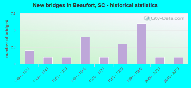
- New bridges - historical statistics
- 21930-1939
- 11940-1949
- 11950-1959
- 41960-1969
- 11970-1979
- 31980-1989
- 61990-1999
- 12000-2009
- 12010-2019


- Bridge Condition - Deck
- 11.1%Very good
- 33.3%Good
- 55.6%Satisfactory

- Bridge Condition - Superstructure
- 22.2%Very good
- 27.8%Good
- 33.3%Satisfactory
- 16.7%Fair

- Bridge Condition - Substructure
- 22.2%Very good
- 22.2%Good
- 38.9%Satisfactory
- 11.1%Fair
- 5.6%Poor

- Bridge Condition - Channel
- 10.5%Very good
- 84.2%Good
- 5.3%Satisfactory

- Bridge Condition - Culverts
- 50.0%Very good
- 50.0%Satisfactory
Find on map >> Show street view
Structure Number: 2SC03, Location: 1.1 KM S. OF MALECON DR. (Lat: 32.334556, Lng: -80.671972), Route carried "on" structure: Other road , Year Built: 1941, Status: Open, Structure Length: 10.97m (35.99ft), Average Daily Traffic: 50 (year 2013), Truck Traffic: 5%, Average Future Daily Traffic: 55 (year 2032), Design Load: HS 15, Features Intersected: BALLAST CREEK, Facility Carried by Structure: CUBA STREET
Minimum Vertical Clearance: 30+ m (98+ ft), Kilometerpoint: 0.000, Lanes on structure: 2, Owner: Navy/Marines, Approaching Roadway Width: 6.7m (22.0ft), Material/Design: Concrete, Design/Construction: Tee Beam, Number Of Spans In Main Unit: 12, Length of Maximum Span: 9.1m (29.9ft), Curb or Sidewalk Widths: Left: 0.2m (0.7ft), Right: 0.2m (0.7ft), Curb-To-Curb Width: 7.3m (24.0ft), Out-to-Out Width: 7.8m (25.6ft)
Condition: Deck: Satisfactory, Superstructure: Good, Substructure: Good, Channel: Satisfactory, Operating Rating: 45.8 metric tons, Method Used To Determine Operating Rating: Load Factor (LF), Inventory Rating: 27.1 metric tons, Method Used To Determine Inventory Rating: Load Factor (LF), Structural Evaluation: Equal to present minimum criteria, Deck Geometry: Equal to present minimum criteria, Waterway Adequacy: Superior to present desirable criteria, Approach Roadway Alignment: Equal to present desirable criteria, Length Of Structure Improvement: 10.97m (35.99ft), Designated Inspection Frequency: Every 24 months, Underwater Inspection Frequency: Every 60 months, Inspection Date: April 2021, Underwater Inspection Date: May 2019, Bridge Improvement Cost: $6,000, Roadway Improvement Cost: $1,000, Total Project Cost: $7,000 ( Estimate for 2021), Deck Structure Type: Concrete Cast-file-Place
Find on map >> Show street view
Structure Number: 2SC0896, Location: 2.0 KM NW OF WAKE BLVD. (Lat: 32.361889, Lng: -80.712944), Route carried "on" structure: Other road , Year Built: 1954, Year Reconstructed: 1989, Status: Open, Structure Length: 11.27m (36.98ft), Average Daily Traffic: 2,000 (year 2013), Truck Traffic: 10%, Average Future Daily Traffic: 2,050 (year 2032), Features Intersected: ARCHERS CREEK, Facility Carried by Structure: MALECON DR
Minimum Vertical Clearance: 30+ m (98+ ft), Kilometerpoint: 0.000, Lanes on structure: 2, Owner: Navy/Marines, Approaching Roadway Width: 7.2m (23.6ft), Navigation Control: Yes ( Vertical Clearance: 6.5m (21.3ft), Horizontal Clearance: 10.7m (35.1ft)), Material/Design: Concrete, Design/Construction: Tee Beam, Number Of Spans In Main Unit: 19, Length of Maximum Span: 11.6m (38.1ft), Curb or Sidewalk Widths: Left: 1.3m (4.3ft), Right: 1.3m (4.3ft), Curb-To-Curb Width: 8.5m (27.9ft), Out-to-Out Width: 11.1m (36.4ft)
Condition: Deck: Satisfactory, Superstructure: Satisfactory, Substructure: Satisfactory, Channel: Good, Operating Rating: 37.6 metric tons, Method Used To Determine Operating Rating: Load Factor (LF), Inventory Rating: 35.6 metric tons, Method Used To Determine Inventory Rating: Load Factor (LF), Structural Evaluation: Equal to present minimum criteria, Deck Geometry: Somewhat better than minimum adequacy, Waterway Adequacy: Superior to present desirable criteria, Approach Roadway Alignment: Equal to present desirable criteria, Length Of Structure Improvement: 11.27m (36.98ft), Designated Inspection Frequency: Every 24 months, Underwater Inspection Frequency: Every 60 months, Inspection Date: April 2021, Underwater Inspection Date: May 2019, Bridge Improvement Cost: $21,000, Roadway Improvement Cost: $105,000, Total Project Cost: $126,000 ( Estimate for 2021), Deck Structure Type: Concrete Cast-file-Place, Wearing Surface/Protective System: Wearing Surface: Bituminous
Find on map >> Show street view
Structure Number: 626, Location: 4.0 MI SE BEAUFORT (Lat: 32.397856, Lng: -80.615486), Route carried "on" structure: US 21, Year Built: 2000, Status: Open, Structure Length: 15.54m (50.98ft), Average Daily Traffic: 18,100 (year 2020), Truck Traffic: 4%, Average Future Daily Traffic: 22,444 (year 2040), Design Load: Railroad, Features Intersected: CHOWAN CREEK
Minimum Vertical Clearance: 30+ m (98+ ft), Kilometerpoint: 19.555, Lanes on structure: 2, Base Highway Network: Yes, Owner: State Highway Agency, Approaching Roadway Width: 10.0m (32.8ft), Material/Design: Concrete continuous, Design/Construction: Slab, Number Of Spans In Main Unit: 17, Length of Maximum Span: 9.1m (29.9ft), Curb-To-Curb Width: 16.5m (54.1ft), Out-to-Out Width: 17.4m (57.1ft)
Condition: Deck: Good, Superstructure: Good, Substructure: Good, Channel: Good, Operating Rating: 60.9 metric tons, Method Used To Determine Operating Rating: Load and Resistance Factor Rating (LRFR) rating reported by rating factor(RF) method using HL-93 loadings, Inventory Rating: 47.0 metric tons, Method Used To Determine Inventory Rating: Load and Resistance Factor Rating (LRFR) rating reported by rating factor(RF) method using HL-93 loadings, Structural Evaluation: Better than present minimum criteria, Deck Geometry: Superior to present desirable criteria, Waterway Adequacy: Equal to present minimum criteria, Approach Roadway Alignment: Equal to present desirable criteria, Length Of Structure Improvement: 15.54m (50.98ft), Designated Inspection Frequency: Every 24 months, Inspection Date: September 2020, Deck Structure Type: Concrete Cast-file-Place, Wearing Surface/Protective System: Wearing Surface: Monolithic Concrete
Find on map >> Show street view
Structure Number: 816, Location: 4.4 MI S SENECA (Lat: 34.616242, Lng: -82.980814), Route carried "on" structure: State highway 59, Year Built: 1937, Status: Open, Structure Length: 1.49m (4.89ft), Average Daily Traffic: 6,700 (year 2020), Truck Traffic: 6%, Average Future Daily Traffic: 10,653 (year 2040), Design Load: H 15, Features Intersected: SNOW CREEK
Minimum Vertical Clearance: 30+ m (98+ ft), Kilometerpoint: 14.458, Lanes on structure: 2, Base Highway Network: Yes, Owner: State Highway Agency, Approaching Roadway Width: 10.4m (34.1ft), Skew: 3 degrees, Material/Design: Concrete, Design/Construction: Culvert, Number Of Spans In Main Unit: 1, Length of Maximum Span: 14.9m (48.9ft), Curb-To-Curb Width: 15.8m (51.8ft), Out-to-Out Width: 16.5m (54.1ft)
Condition: Channel: Good, Culverts: Satisfactory, Operating Rating: 31.4 metric tons, Method Used To Determine Operating Rating: Load and Resistance Factor Rating (LRFR) rating reported by rating factor(RF) method using HL-93 loadings, Inventory Rating: 25.9 metric tons, Method Used To Determine Inventory Rating: Load and Resistance Factor Rating (LRFR) rating reported by rating factor(RF) method using HL-93 loadings, Structural Evaluation: Equal to present minimum criteria, Deck Geometry: Superior to present desirable criteria, Waterway Adequacy: Equal to present desirable criteria, Approach Roadway Alignment: Equal to present desirable criteria, Length Of Structure Improvement: 1.49m (4.89ft), Designated Inspection Frequency: Every 24 months, Inspection Date: May 2020, Deck Structure Type: Concrete Cast-file-Place, Wearing Surface/Protective System: Wearing Surface: Bituminous
Find on map >> Show street view
Structure Number: 901, Location: 8.9MI NE OF PICKENS (Lat: 35.000614, Lng: -82.652703), Route carried "on" structure: State highway 8, Year Built: 1938, Status: Posted for load, Structure Length: 4.57m (14.99ft), Average Daily Traffic: 3,100 (year 2020), Truck Traffic: 9%, Average Future Daily Traffic: 4,929 (year 2040), Design Load: H 15, Features Intersected: OOLENOY RIVER
Minimum Vertical Clearance: 30+ m (98+ ft), Kilometerpoint: 32.985, Lanes on structure: 2, Base Highway Network: Yes, Owner: State Highway Agency, Approaching Roadway Width: 7.0m (23.0ft), Material/Design: Steel, Design/Construction: Stringer/Multi-beam, Number Of Spans In Main Unit: 6, Length of Maximum Span: 7.6m (24.9ft), Curb-To-Curb Width: 6.8m (22.3ft), Out-to-Out Width: 7.3m (24.0ft)
Condition: Deck: Satisfactory, Superstructure: Fair, Substructure: Poor, Channel: Good, Operating Rating: 19.8 metric tons, Method Used To Determine Operating Rating: Load and Resistance Factor Rating (LRFR) rating reported by rating factor(RF) method using HL-93 loadings, Inventory Rating: 15.2 metric tons, Method Used To Determine Inventory Rating: Load and Resistance Factor Rating (LRFR) rating reported by rating factor(RF) method using HL-93 loadings, Structural Evaluation: Meets minimum limits, Deck Geometry: High priority of replacement, Waterway Adequacy: Equal to present desirable criteria, Approach Roadway Alignment: Equal to present desirable criteria, Bridge Posting: Required (Relationship of Operating Rating to Maximum Legal Load: 30.0 - 39.9% below), Length Of Structure Improvement: 5.49m (18.01ft), Designated Inspection Frequency: Every 12 months, Other Special Inspection Frequency: Every 24 months, Inspection Date: June 2021, Other Special Inspection Date: December 2021, Bridge Improvement Cost: $554,000, Roadway Improvement Cost: $139,000, Total Project Cost: $831,000 ( Estimate for 2021), Deck Structure Type: Concrete Cast-file-Place, Wearing Surface/Protective System: Wearing Surface: Bituminous
Find on map >> Show street view
Structure Number: 1861, Location: 3.5 MI NE BEAUFORT (Lat: 32.482783, Lng: -80.654900), Route carried "on" structure: State highway 72, Year Built: 1996, Status: Open, Structure Length: 2.74m (8.99ft), Average Daily Traffic: 2,400 (year 2020), Truck Traffic: 5%, Average Future Daily Traffic: 2,976 (year 2040), Design Load: HS 25 or greater, Features Intersected: BROOMFIELD CREEK
Minimum Vertical Clearance: 30+ m (98+ ft), Kilometerpoint: 6.013, Lanes on structure: 2, Base Highway Network: Yes, Owner: State Highway Agency, Approaching Roadway Width: 6.3m (20.7ft), Material/Design: Concrete continuous, Design/Construction: Slab, Number Of Spans In Main Unit: 3, Length of Maximum Span: 9.1m (29.9ft), Curb-To-Curb Width: 11.0m (36.1ft), Out-to-Out Width: 11.9m (39.0ft)
Condition: Deck: Good, Superstructure: Good, Substructure: Good, Channel: Good, Operating Rating: 47.0 metric tons, Method Used To Determine Operating Rating: Load and Resistance Factor Rating (LRFR) rating reported by rating factor(RF) method using HL-93 loadings, Inventory Rating: 36.3 metric tons, Method Used To Determine Inventory Rating: Load and Resistance Factor Rating (LRFR) rating reported by rating factor(RF) method using HL-93 loadings, Structural Evaluation: Better than present minimum criteria, Deck Geometry: Somewhat better than minimum adequacy, Waterway Adequacy: Equal to present minimum criteria, Approach Roadway Alignment: Equal to present desirable criteria, Length Of Structure Improvement: 2.74m (8.99ft), Designated Inspection Frequency: Every 24 months, Inspection Date: August 2021, Deck Structure Type: Concrete Cast-file-Place, Wearing Surface/Protective System: Wearing Surface: Monolithic Concrete
Find on map >> Show street view
Structure Number: 3186, Location: IN TOWN OF BEAUFORT (Lat: 32.427725, Lng: -80.669228), Route carried "on" structure: Business US 21, Year Built: 1960, Status: Posted for load-capacity, Structure Length: 69.80m (229.00ft), Average Daily Traffic: 13,400 (year 2020), Truck Traffic: 3%, Average Future Daily Traffic: 15,008 (year 2040), Design Load: HS 15, Features Intersected: BEAUFORT RIVER
Minimum Vertical Clearance: 4.57m (14.99ft), Kilometerpoint: 2.026, Lanes on structure: 2, Owner: State Highway Agency, Approaching Roadway Width: 12.2m (40.0ft), Navigation Control: Yes ( Vertical Clearance: 9.1m (29.9ft), Horizontal Clearance: 27.1m (88.9ft)), Material/Design: Steel, Design/Construction: Movable - Swing, Number Of Spans In Main Unit: 1, Number Of Approach Spans: 36, Length of Maximum Span: 74.7m (245.1ft), Curb or Sidewalk Widths: Left: 1.2m (3.9ft), Right: 0.6m (2.0ft), Curb-To-Curb Width: 7.5m (24.6ft), Out-to-Out Width: 10.2m (33.5ft)
Condition: Deck: Good, Superstructure: Fair, Substructure: Good, Channel: Good, Operating Rating: 28.8 metric tons, Method Used To Determine Operating Rating: Load and Resistance Factor Rating (LRFR) rating reported by rating factor(RF) method using HL-93 loadings, Inventory Rating: 21.7 metric tons, Method Used To Determine Inventory Rating: Load and Resistance Factor Rating (LRFR) rating reported by rating factor(RF) method using HL-93 loadings, Structural Evaluation: Somewhat better than minimum adequacy, Deck Geometry: High priority of replacement, Waterway Adequacy: Equal to present minimum criteria, Approach Roadway Alignment: Equal to present desirable criteria, Bridge Posting: Required (Relationship of Operating Rating to Maximum Legal Load: 0.1 - 9.9% below), Length Of Structure Improvement: 69.80m (229.00ft), Designated Inspection Frequency: Every 24 months, Critical Feature Inspection Frequency: Every 24 months, Underwater Inspection Frequency: Every 60 months, Inspection Date: November 2020, Critical Feature Inspection Date: November 2020, Underwater Inspection Date: Febuary 2019, Bridge Improvement Cost: $8,831,000, Roadway Improvement Cost: $2,208,000, Total Project Cost: $13,247,000 ( Estimate for 2021), Deck Structure Type: Concrete Cast-file-Place, Wearing Surface/Protective System: Wearing Surface: Monolithic Concrete
Find on map >> Show street view
Structure Number: 4764, Location: 4.8 MI NE ST GEORGE (Lat: 33.211556, Lng: -80.492375), Route carried "on" structure: State highway 378, Year Built: 1966, Status: Open, Structure Length: 0.91m (2.99ft), Average Daily Traffic: 400 (year 2020), Truck Traffic: 8%, Average Future Daily Traffic: 584 (year 2040), Design Load: H 15, Features Intersected: BIG BRANCH
Minimum Vertical Clearance: 30+ m (98+ ft), Kilometerpoint: 2.997, Lanes on structure: 2, Owner: State Highway Agency, Approaching Roadway Width: 5.8m (19.0ft), Material/Design: Concrete, Design/Construction: Slab, Number Of Spans In Main Unit: 2, Length of Maximum Span: 4.6m (15.1ft), Curb or Sidewalk Widths: Left: 0.2m (0.7ft), Right: 0.2m (0.7ft), Curb-To-Curb Width: 7.9m (25.9ft), Out-to-Out Width: 8.4m (27.6ft)
Condition: Deck: Good, Superstructure: Good, Substructure: Fair, Channel: Good, Operating Rating: 32.1 metric tons, Method Used To Determine Operating Rating: Load and Resistance Factor Rating (LRFR) rating reported by rating factor(RF) method using HL-93 loadings, Inventory Rating: 24.6 metric tons, Method Used To Determine Inventory Rating: Load and Resistance Factor Rating (LRFR) rating reported by rating factor(RF) method using HL-93 loadings, Structural Evaluation: Somewhat better than minimum adequacy, Deck Geometry: Somewhat better than minimum adequacy, Waterway Adequacy: Equal to present minimum criteria, Approach Roadway Alignment: Equal to present desirable criteria, Length Of Structure Improvement: 0.91m (2.99ft), Designated Inspection Frequency: Every 24 months, Inspection Date: May 2021, Deck Structure Type: Concrete Precast Panels, Wearing Surface/Protective System: Wearing Surface: Bituminous
Find on map >> Show street view
Structure Number: 4938, Location: 1.3 MI SW BEAUFORT (Lat: 32.431294, Lng: -80.708350), Route carried "on" structure: State highway 457, Year Built: 1967, Status: Open, Structure Length: 1.37m (4.49ft), Average Daily Traffic: 2,300 (year 2020), Truck Traffic: 5%, Average Future Daily Traffic: 2,944 (year 2040), Design Load: H 15, Features Intersected: TRIB TO BATTERY CREEK
Minimum Vertical Clearance: 30+ m (98+ ft), Kilometerpoint: 0.097, Lanes on structure: 2, Owner: State Highway Agency, Approaching Roadway Width: 6.1m (20.0ft), Material/Design: Concrete, Design/Construction: Slab, Number Of Spans In Main Unit: 3, Length of Maximum Span: 4.6m (15.1ft), Curb or Sidewalk Widths: Left: 0.2m (0.7ft), Right: 0.2m (0.7ft), Curb-To-Curb Width: 7.9m (25.9ft), Out-to-Out Width: 8.4m (27.6ft)
Condition: Deck: Good, Superstructure: Good, Substructure: Satisfactory, Channel: Good, Operating Rating: 29.2 metric tons, Method Used To Determine Operating Rating: Load and Resistance Factor Rating (LRFR) rating reported by rating factor(RF) method using HL-93 loadings, Inventory Rating: 22.4 metric tons, Method Used To Determine Inventory Rating: Load and Resistance Factor Rating (LRFR) rating reported by rating factor(RF) method using HL-93 loadings, Structural Evaluation: Somewhat better than minimum adequacy, Deck Geometry: High priority of corrective action, Waterway Adequacy: Equal to present minimum criteria, Approach Roadway Alignment: Equal to present desirable criteria, Length Of Structure Improvement: 2.06m (6.76ft), Designated Inspection Frequency: Every 24 months, Inspection Date: August 2021, Bridge Improvement Cost: $94,000, Roadway Improvement Cost: $24,000, Total Project Cost: $141,000 ( Estimate for 2021), Deck Structure Type: Concrete Precast Panels, Wearing Surface/Protective System: Wearing Surface: Bituminous
Find on map >> Show street view
Structure Number: 5219, Location: 8.7 MI NW OF BEAUFORT (Lat: 32.541022, Lng: -80.745461), Route carried "on" structure: US 21, Year Built: 1968, Status: Open, Structure Length: 28.96m (95.01ft), Average Daily Traffic: 6,750 (year 2020), Truck Traffic: 9%, Average Future Daily Traffic: 16,673 (year 2040), Design Load: HS 20, Features Intersected: WHALE BRANCH
Minimum Vertical Clearance: 30+ m (98+ ft), Kilometerpoint: 52.664, Lanes on structure: 2, Base Highway Network: Yes, Owner: State Highway Agency, Approaching Roadway Width: 9.1m (29.9ft), Navigation Control: Yes ( Vertical Clearance: 6.1m (20.0ft), Horizontal Clearance: 21.3m (69.9ft)), Material/Design: Steel, Design/Construction: Stringer/Multi-beam, Number Of Spans In Main Unit: 4, Number Of Approach Spans: 11, Length of Maximum Span: 30.5m (100.1ft), Curb or Sidewalk Widths: Left: 0.6m (2.0ft), Right: 0.6m (2.0ft), Curb-To-Curb Width: 9.1m (29.9ft), Out-to-Out Width: 10.7m (35.1ft)
Condition: Deck: Satisfactory, Superstructure: Fair, Substructure: Satisfactory, Channel: Good, Operating Rating: 45.0 metric tons, Method Used To Determine Operating Rating: Load and Resistance Factor Rating (LRFR) rating reported by rating factor(RF) method using HL-93 loadings, Inventory Rating: 31.8 metric tons, Method Used To Determine Inventory Rating: Load and Resistance Factor Rating (LRFR) rating reported by rating factor(RF) method using HL-93 loadings, Structural Evaluation: Somewhat better than minimum adequacy, Deck Geometry: Meets minimum limits, Waterway Adequacy: Equal to present minimum criteria, Approach Roadway Alignment: Equal to present desirable criteria, Length Of Structure Improvement: 28.96m (95.01ft), Designated Inspection Frequency: Every 24 months, Underwater Inspection Frequency: Every 60 months, Inspection Date: September 2020, Underwater Inspection Date: January 2019, Deck Structure Type: Concrete Cast-file-Place, Wearing Surface/Protective System: Wearing Surface: Monolithic Concrete
Find on map >> Show street view
Structure Number: 6428, Location: 7.2 MI SE BEAUFORT (Lat: 32.391894, Lng: -80.576306), Route carried "on" structure: State highway 45, Year Built: 1974, Status: Open, Structure Length: 1.37m (4.49ft), Average Daily Traffic: 5,800 (year 2020), Truck Traffic: 4%, Average Future Daily Traffic: 8,468 (year 2040), Design Load: H 15, Features Intersected: TRIB TO CAPERS CREEK
Minimum Vertical Clearance: 30+ m (98+ ft), Kilometerpoint: 13.910, Lanes on structure: 2, Owner: State Highway Agency, Approaching Roadway Width: 6.0m (19.7ft), Material/Design: Concrete, Design/Construction: Slab, Number Of Spans In Main Unit: 3, Length of Maximum Span: 4.6m (15.1ft), Curb-To-Curb Width: 8.8m (28.9ft), Out-to-Out Width: 10.1m (33.1ft)
Condition: Deck: Satisfactory, Superstructure: Satisfactory, Substructure: Satisfactory, Channel: Good, Operating Rating: 29.8 metric tons, Method Used To Determine Operating Rating: Load and Resistance Factor Rating (LRFR) rating reported by rating factor(RF) method using HL-93 loadings, Inventory Rating: 23.0 metric tons, Method Used To Determine Inventory Rating: Load and Resistance Factor Rating (LRFR) rating reported by rating factor(RF) method using HL-93 loadings, Structural Evaluation: Somewhat better than minimum adequacy, Deck Geometry: High priority of replacement, Waterway Adequacy: Equal to present minimum criteria, Approach Roadway Alignment: Equal to present minimum criteria, Length Of Structure Improvement: 2.06m (6.76ft), Designated Inspection Frequency: Every 24 months, Inspection Date: August 2021, Bridge Improvement Cost: $99,000, Roadway Improvement Cost: $25,000, Total Project Cost: $149,000 ( Estimate for 2021), Deck Structure Type: Concrete Precast Panels, Wearing Surface/Protective System: Wearing Surface: Bituminous
Find on map >> Show street view
Structure Number: 7425, Location: SOUTHEAST OF BEAUFORT (Lat: 32.393922, Lng: -80.675394), Route carried "on" structure: US 21, Year Built: 1981, Status: Open, Structure Length: 128.32m (421.00ft), Average Daily Traffic: 11,800 (year 2020), Truck Traffic: 4%, Average Future Daily Traffic: 13,216 (year 2040), Design Load: HS 20, Features Intersected: BEAUFORT RIVER
Minimum Vertical Clearance: 30+ m (98+ ft), Kilometerpoint: 26.139, Lanes on structure: 2, Owner: State Highway Agency, Approaching Roadway Width: 11.0m (36.1ft), Navigation Control: Yes ( Vertical Clearance: 19.8m (65.0ft), Horizontal Clearance: 33.5m (109.9ft)), Material/Design: Steel continuous, Design/Construction: Stringer/Multi-beam, Number Of Spans In Main Unit: 15, Number Of Approach Spans: 53, Length of Maximum Span: 51.8m (169.9ft), Curb-To-Curb Width: 11.0m (36.1ft), Out-to-Out Width: 12.1m (39.7ft)
Condition: Deck: Satisfactory, Superstructure: Satisfactory, Substructure: Fair, Channel: Good, Operating Rating: 19.8 metric tons, Method Used To Determine Operating Rating: Load and Resistance Factor Rating (LRFR) rating reported by rating factor(RF) method using HL-93 loadings, Inventory Rating: 15.2 metric tons, Method Used To Determine Inventory Rating: Load and Resistance Factor Rating (LRFR) rating reported by rating factor(RF) method using HL-93 loadings, Structural Evaluation: High priority of corrective action, Deck Geometry: Meets minimum limits, Waterway Adequacy: Equal to present desirable criteria, Approach Roadway Alignment: Equal to present desirable criteria, Length Of Structure Improvement: 128.32m (421.00ft), Designated Inspection Frequency: Every 24 months, Underwater Inspection Frequency: Every 60 months, Inspection Date: September 2020, Underwater Inspection Date: Febuary 2021, Bridge Improvement Cost: $6,384,000, Roadway Improvement Cost: $1,596,000, Total Project Cost: $9,576,000 ( Estimate for 2021), Deck Structure Type: Concrete Cast-file-Place, Wearing Surface/Protective System: Wearing Surface: Monolithic Concrete
Find on map >> Show street view
Structure Number: 7631, Location: 11MI N KINGSTREE (Lat: 33.848617, Lng: -79.847228), Route carried "on" structure: State highway 33, Year Built: 1982, Status: Open, Structure Length: 1.37m (4.49ft), Average Daily Traffic: 1,450 (year 2020), Truck Traffic: 9%, Average Future Daily Traffic: 2,117 (year 2040), Design Load: H 15, Features Intersected: KINGSTREE SWAMP CANAL
Minimum Vertical Clearance: 30+ m (98+ ft), Kilometerpoint: 3.148, Lanes on structure: 2, Owner: State Highway Agency, Approaching Roadway Width: 6.7m (22.0ft), Material/Design: Concrete, Design/Construction: Slab, Number Of Spans In Main Unit: 3, Length of Maximum Span: 4.6m (15.1ft), Curb-To-Curb Width: 9.6m (31.5ft), Out-to-Out Width: 10.1m (33.1ft)
Condition: Deck: Satisfactory, Superstructure: Satisfactory, Substructure: Satisfactory, Channel: Good, Operating Rating: 25.9 metric tons, Method Used To Determine Operating Rating: Load and Resistance Factor Rating (LRFR) rating reported by rating factor(RF) method using HL-93 loadings, Inventory Rating: 19.8 metric tons, Method Used To Determine Inventory Rating: Load and Resistance Factor Rating (LRFR) rating reported by rating factor(RF) method using HL-93 loadings, Structural Evaluation: Somewhat better than minimum adequacy, Deck Geometry: Somewhat better than minimum adequacy, Waterway Adequacy: Equal to present minimum criteria, Approach Roadway Alignment: Equal to present desirable criteria, Bridge Posting: Required (Relationship of Operating Rating to Maximum Legal Load: 10.0 - 19.9% below), Length Of Structure Improvement: 1.37m (4.49ft), Designated Inspection Frequency: Every 24 months, Inspection Date: September 2021, Deck Structure Type: Concrete Precast Panels, Wearing Surface/Protective System: Wearing Surface: Bituminous
Find on map >> Show street view
Structure Number: 8027, Location: 12.5 MI NE WALHALLA (Lat: 34.902903, Lng: -82.929003), Route carried "on" structure: State highway 44, Year Built: 1986, Status: Open, Structure Length: 0.82m (2.69ft), Average Daily Traffic: 225 (year 2020), Truck Traffic: 5%, Average Future Daily Traffic: 288 (year 2040), Design Load: H 20, Features Intersected: FALL CREEK
Minimum Vertical Clearance: 30+ m (98+ ft), Kilometerpoint: 3.751, Lanes on structure: 2, Owner: State Highway Agency, Approaching Roadway Width: 6.4m (21.0ft), Skew: 4 degrees, Material/Design: Concrete, Design/Construction: Culvert, Number Of Spans In Main Unit: 2, Length of Maximum Span: 3.7m (12.1ft), Curb-To-Curb Width: 12.2m (40.0ft), Out-to-Out Width: 25.9m (85.0ft)
Condition: Channel: Good, Culverts: Very good, Operating Rating: 63.2 metric tons, Method Used To Determine Operating Rating: Load and Resistance Factor Rating (LRFR) rating reported by rating factor(RF) method using HL-93 loadings, Inventory Rating: 48.6 metric tons, Method Used To Determine Inventory Rating: Load and Resistance Factor Rating (LRFR) rating reported by rating factor(RF) method using HL-93 loadings, Structural Evaluation: Equal to present desirable criteria, Deck Geometry: Superior to present desirable criteria, Waterway Adequacy: Equal to present desirable criteria, Approach Roadway Alignment: Equal to present desirable criteria, Length Of Structure Improvement: 0.82m (2.69ft), Designated Inspection Frequency: Every 24 months, Inspection Date: March 2021
Find on map >> Show street view
Structure Number: 8413, Location: 8.7 MI NW OF BEAUFORT (Lat: 32.540614, Lng: -80.745122), Route carried "on" structure: US 21, Year Built: 1991, Status: Open, Structure Length: 39.62m (129.99ft), Average Daily Traffic: 6,750 (year 2020), Truck Traffic: 9%, Average Future Daily Traffic: 16,673 (year 2040), Design Load: HS 20+Mod, Features Intersected: WHALE BRANCH
Minimum Vertical Clearance: 30+ m (98+ ft), Kilometerpoint: 52.579, Lanes on structure: 2, Base Highway Network: Yes, Owner: State Highway Agency, Approaching Roadway Width: 9.8m (32.2ft), Skew: 10 degrees, Navigation Control: Yes ( Vertical Clearance: 6.1m (20.0ft), Horizontal Clearance: 18.3m (60.0ft)), Material/Design: Prestressed concrete, Design/Construction: Stringer/Multi-beam, Number Of Spans In Main Unit: 4, Number Of Approach Spans: 30, Length of Maximum Span: 30.5m (100.1ft), Curb-To-Curb Width: 12.2m (40.0ft), Out-to-Out Width: 13.1m (43.0ft)
Condition: Deck: Satisfactory, Superstructure: Satisfactory, Substructure: Satisfactory, Channel: Good, Operating Rating: 35.3 metric tons, Method Used To Determine Operating Rating: Load and Resistance Factor Rating (LRFR) rating reported by rating factor(RF) method using HL-93 loadings, Inventory Rating: 16.8 metric tons, Method Used To Determine Inventory Rating: Load and Resistance Factor Rating (LRFR) rating reported by rating factor(RF) method using HL-93 loadings, Structural Evaluation: Meets minimum limits, Deck Geometry: Better than present minimum criteria, Waterway Adequacy: Equal to present minimum criteria, Approach Roadway Alignment: Equal to present desirable criteria, Length Of Structure Improvement: 39.62m (129.99ft), Designated Inspection Frequency: Every 24 months, Underwater Inspection Frequency: Every 60 months, Inspection Date: September 2020, Underwater Inspection Date: January 2019, Deck Structure Type: Concrete Cast-file-Place, Wearing Surface/Protective System: Wearing Surface: Monolithic Concrete
Find on map >> Show street view
Structure Number: 9011, Location: 4.2 MI SW OF GREENVILLE (Lat: 34.791383, Lng: -82.424850), Route carried "on" structure: Interstate 85, Year Built: 1996, Status: Open, Structure Length: 9.75m (31.99ft), Average Daily Traffic: 38,950 (year 2020), Truck Traffic: 9%, Average Future Daily Traffic: 55,699 (year 2040), Design Load: HS 20, Features Intersected: SC 20, S-245, NS RR
Minimum Vertical Clearance: 30+ m (98+ ft), Kilometerpoint: 68.743, Lanes on structure: 4, Lanes under structure: 6, Base Highway Network: Yes, Owner: State Highway Agency, Approaching Roadway Width: 21.3m (69.9ft), Material/Design: Steel continuous, Design/Construction: Stringer/Multi-beam, Number Of Spans In Main Unit: 4, Length of Maximum Span: 31.4m (103.0ft), Curb-To-Curb Width: 21.2m (69.6ft), Out-to-Out Width: 22.1m (72.5ft)
Condition: Deck: Good, Superstructure: Very good, Substructure: Very good, Operating Rating: 34.3 metric tons, Method Used To Determine Operating Rating: Load and Resistance Factor Rating (LRFR) rating reported by rating factor(RF) method using HL-93 loadings, Inventory Rating: 26.2 metric tons, Method Used To Determine Inventory Rating: Load and Resistance Factor Rating (LRFR) rating reported by rating factor(RF) method using HL-93 loadings, Structural Evaluation: Equal to present minimum criteria, Deck Geometry: Better than present minimum criteria, Underclear: Equal to present minimum criteria, Approach Roadway Alignment: Equal to present desirable criteria, Length Of Structure Improvement: 9.75m (31.99ft), Designated Inspection Frequency: Every 24 months, Inspection Date: August 2020, Deck Structure Type: Concrete Cast-file-Place, Wearing Surface/Protective System: Wearing Surface: Monolithic Concrete
Find on map >> Show street view
Structure Number: 9012, Location: 2.0 MI E SIMPSONVILLE (Lat: 34.728906, Lng: -82.221617), Route carried "on" structure: State highway 160, Year Built: 1996, Status: Open, Structure Length: 2.41m (7.91ft), Average Daily Traffic: 4,100 (year 2020), Truck Traffic: 3%, Average Future Daily Traffic: 6,273 (year 2040), Design Load: HS 20, Features Intersected: BIG DURBIN CREEK
Minimum Vertical Clearance: 30+ m (98+ ft), Kilometerpoint: 3.275, Lanes on structure: 2, Owner: State Highway Agency, Approaching Roadway Width: 6.7m (22.0ft), Material/Design: Concrete continuous, Design/Construction: Slab, Number Of Spans In Main Unit: 3, Length of Maximum Span: 10.1m (33.1ft), Curb-To-Curb Width: 10.2m (33.5ft), Out-to-Out Width: 11.1m (36.4ft)
Condition: Deck: Very good, Superstructure: Very good, Substructure: Very good, Channel: Very good, Operating Rating: 60.9 metric tons, Method Used To Determine Operating Rating: Load and Resistance Factor Rating (LRFR) rating reported by rating factor(RF) method using HL-93 loadings, Inventory Rating: 47.3 metric tons, Method Used To Determine Inventory Rating: Load and Resistance Factor Rating (LRFR) rating reported by rating factor(RF) method using HL-93 loadings, Structural Evaluation: Equal to present desirable criteria, Deck Geometry: Meets minimum limits, Waterway Adequacy: Equal to present desirable criteria, Approach Roadway Alignment: Equal to present desirable criteria, Length Of Structure Improvement: 2.41m (7.91ft), Designated Inspection Frequency: Every 24 months, Inspection Date: July 2021, Deck Structure Type: Concrete Cast-file-Place, Wearing Surface/Protective System: Wearing Surface: Monolithic Concrete
Find on map >> Show street view
Structure Number: 9013, Location: 5.6MI N TRAVELERS REST (Lat: 35.044144, Lng: -82.473975), Route carried "on" structure: State highway 178, Year Built: 1996, Status: Open, Structure Length: 4.27m (14.01ft), Average Daily Traffic: 500 (year 2020), Truck Traffic: 5%, Average Future Daily Traffic: 640 (year 2040), Design Load: HS 25 or greater, Features Intersected: NORTH SALUDA RIVER
Minimum Vertical Clearance: 30+ m (98+ ft), Kilometerpoint: 2.181, Lanes on structure: 2, Owner: State Highway Agency, Approaching Roadway Width: 6.9m (22.6ft), Material/Design: Prestressed concrete, Design/Construction: Stringer/Multi-beam, Number Of Spans In Main Unit: 3, Length of Maximum Span: 18.3m (60.0ft), Curb-To-Curb Width: 10.4m (34.1ft), Out-to-Out Width: 11.3m (37.1ft)
Condition: Deck: Very good, Superstructure: Very good, Substructure: Very good, Channel: Good, Operating Rating: 56.7 metric tons, Method Used To Determine Operating Rating: Load and Resistance Factor Rating (LRFR) rating reported by rating factor(RF) method using HL-93 loadings, Inventory Rating: 30.8 metric tons, Method Used To Determine Inventory Rating: Load and Resistance Factor Rating (LRFR) rating reported by rating factor(RF) method using HL-93 loadings, Structural Evaluation: Better than present minimum criteria, Deck Geometry: Equal to present minimum criteria, Waterway Adequacy: Equal to present desirable criteria, Approach Roadway Alignment: Equal to present minimum criteria, Length Of Structure Improvement: 4.27m (14.01ft), Designated Inspection Frequency: Every 24 months, Inspection Date: May 2021, Deck Structure Type: Concrete Cast-file-Place, Wearing Surface/Protective System: Wearing Surface: Monolithic Concrete
Find on map >> Show street view
Structure Number: 9133, Location: 11 MI NW BEAUFORT (Lat: 32.572506, Lng: -80.787067), Route carried "on" structure: State highway 59, Year Built: 1997, Status: Open, Structure Length: 2.74m (8.99ft), Average Daily Traffic: 400 (year 2020), Truck Traffic: 7%, Average Future Daily Traffic: 556 (year 2040), Design Load: HS 25 or greater, Features Intersected: FIELD CREEK
Minimum Vertical Clearance: 30+ m (98+ ft), Kilometerpoint: 3.737, Lanes on structure: 2, Owner: State Highway Agency, Approaching Roadway Width: 6.4m (21.0ft), Material/Design: Concrete continuous, Design/Construction: Slab, Number Of Spans In Main Unit: 3, Length of Maximum Span: 9.1m (29.9ft), Curb-To-Curb Width: 10.4m (34.1ft), Out-to-Out Width: 11.3m (37.1ft)
Condition: Deck: Satisfactory, Superstructure: Satisfactory, Substructure: Satisfactory, Channel: Good, Operating Rating: 55.1 metric tons, Method Used To Determine Operating Rating: Load and Resistance Factor Rating (LRFR) rating reported by rating factor(RF) method using HL-93 loadings, Inventory Rating: 42.4 metric tons, Method Used To Determine Inventory Rating: Load and Resistance Factor Rating (LRFR) rating reported by rating factor(RF) method using HL-93 loadings, Structural Evaluation: Equal to present minimum criteria, Deck Geometry: Better than present minimum criteria, Waterway Adequacy: Equal to present minimum criteria, Approach Roadway Alignment: Better than present minimum criteria, Length Of Structure Improvement: 2.74m (8.99ft), Designated Inspection Frequency: Every 24 months, Inspection Date: August 2021, Deck Structure Type: Concrete Cast-file-Place, Wearing Surface/Protective System: Wearing Surface: Monolithic Concrete
Find on map >> Show street view
Structure Number: 9957, Location: SOUTHEAST OF BEAUFORT (Lat: 32.393767, Lng: -80.675408), Route carried "on" structure: US 21, Year Built: 2012, Status: Open, Structure Length: 128.32m (421.00ft), Average Daily Traffic: 11,800 (year 2020), Truck Traffic: 4%, Average Future Daily Traffic: 13,216 (year 2040), Design Load: HL 93, Features Intersected: BEAUFORT RIVER
Minimum Vertical Clearance: 30+ m (98+ ft), Kilometerpoint: 26.139, Lanes on structure: 2, Owner: State Highway Agency, Approaching Roadway Width: 9.1m (29.9ft), Navigation Control: Yes ( Vertical Clearance: 19.8m (65.0ft), Horizontal Clearance: 33.5m (109.9ft)), Material/Design: Prestressed concrete continuous, Design/Construction: Stringer/Multi-beam, Number Of Spans In Main Unit: 23, Number Of Approach Spans: 35, Length of Maximum Span: 51.8m (169.9ft), Curb or Sidewalk Widths: Left: 0.0m, Right: 1.5m (4.9ft), Curb-To-Curb Width: 11.6m (38.1ft), Out-to-Out Width: 13.7m (44.9ft)
Condition: Deck: Satisfactory, Superstructure: Very good, Substructure: Very good, Channel: Very good, Operating Rating: 33.4 metric tons, Method Used To Determine Operating Rating: Load and Resistance Factor Rating (LRFR) rating reported by rating factor(RF) method using HL-93 loadings, Inventory Rating: 25.6 metric tons, Method Used To Determine Inventory Rating: Load and Resistance Factor Rating (LRFR) rating reported by rating factor(RF) method using HL-93 loadings, Structural Evaluation: Equal to present minimum criteria, Deck Geometry: Somewhat better than minimum adequacy, Waterway Adequacy: Equal to present desirable criteria, Approach Roadway Alignment: Equal to present desirable criteria, Length Of Structure Improvement: 128.32m (421.00ft), Designated Inspection Frequency: Every 24 months, Underwater Inspection Frequency: Every 60 months, Inspection Date: September 2020, Underwater Inspection Date: January 2018, Deck Structure Type: Concrete Cast-file-Place, Wearing Surface/Protective System: Wearing Surface: Monolithic Concrete