Bridge Statistics for Beaver Falls, Pennsylvania (PA)
Condition, Traffic, Stress, Structural Evaluation, Project Costs
- National Bridge Inventory (NBI) Statistics
- 13Number of bridges
- 427ft / 130mTotal length
- $3,904,000Total costs
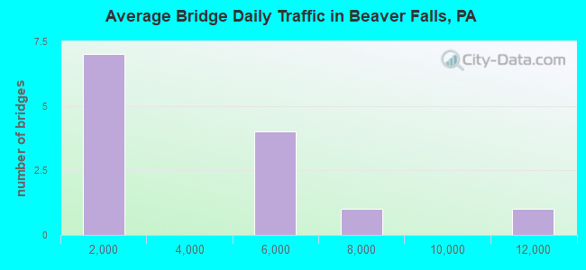
- 39,918Total average daily traffic
- 2,485Total average daily truck traffic
- National Bridge Inventory (NBI) Registered Bridges for Beaver Falls
- No street view available for this location

- New bridges - historical statistics
- 1Before 1900
- 31950-1959
- 11960-1969
- 11970-1979
- 61980-1989
- 12010-2019
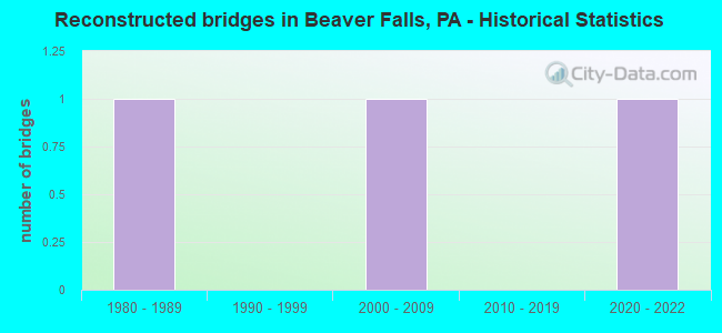
- Reconstructed bridges - Historical Statistics
- 11980-1989
- 01990-1999
- 12000-2009
- 02010-2019
- 12020-2022
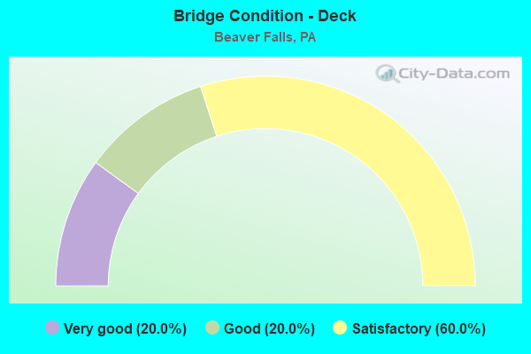
- Bridge Condition - Deck
- 20.0%Very good
- 20.0%Good
- 60.0%Satisfactory
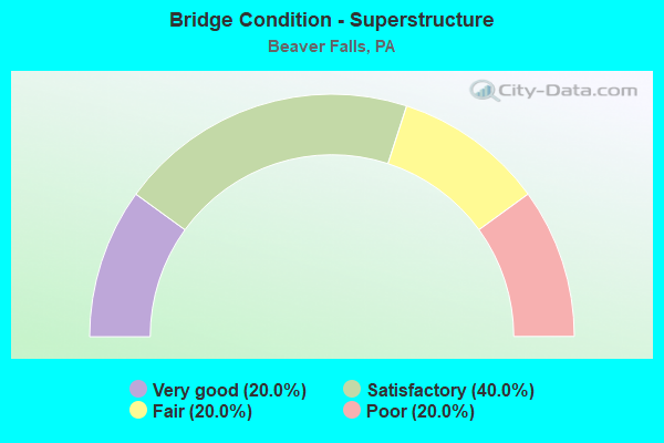
- Bridge Condition - Superstructure
- 20.0%Very good
- 40.0%Satisfactory
- 20.0%Fair
- 20.0%Poor
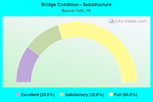
- Bridge Condition - Substructure
- 20.0%Excellent
- 20.0%Satisfactory
- 60.0%Fair
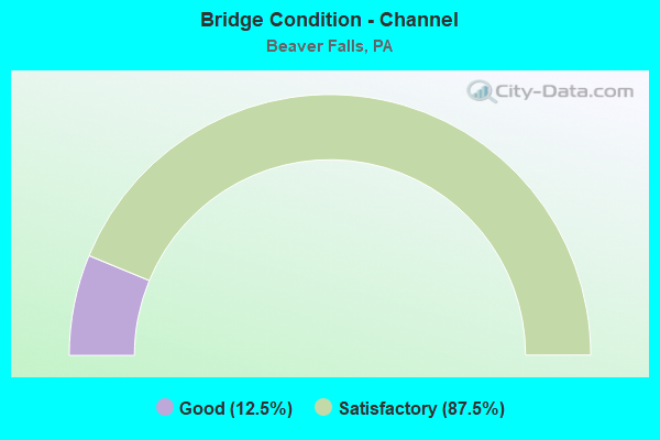
- Bridge Condition - Channel
- 12.5%Good
- 87.5%Satisfactory
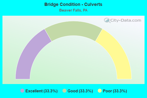
- Bridge Condition - Culverts
- 33.3%Excellent
- 33.3%Good
- 33.3%Poor
Find on map >> Show street view
Structure Number: 3449, Location: 0.2 MI NW OF 5TH AVE (Lat: 40.741122, Lng: -80.319744), Route carried "on" structure: State highway 18, Year Built: 1986, Status: Open, Structure Length: 39.93m (131.00ft), Average Daily Traffic: 5,045 (year 2020), Truck Traffic: 5%, Average Future Daily Traffic: 5,827 (year 2032), Design Load: HS 20+Mod, Features Intersected: NSRC, CSX, BEAVER RIVER
Minimum Vertical Clearance: 30+ m (98+ ft), Kilometerpoint: 40.032, Lanes on structure: 2, Lanes under structure: 4, Base Highway Network: Yes, Owner: State Highway Agency, Approaching Roadway Width: 9.8m (32.2ft), Skew: 9 degrees, Material/Design: Prestressed concrete, Design/Construction: Stringer/Multi-beam, Number Of Spans In Main Unit: 6, Number Of Approach Spans: 5, Length of Maximum Span: 45.7m (149.9ft), Curb or Sidewalk Widths: Left: 0.2m (0.7ft), Right: 0.2m (0.7ft), Curb-To-Curb Width: 9.8m (32.2ft), Out-to-Out Width: 10.8m (35.4ft)
Condition: Deck: Satisfactory, Superstructure: Poor, Substructure: Fair, Channel: Satisfactory, Operating Rating: 66.2 metric tons, Method Used To Determine Operating Rating: Load Factor (LF), Inventory Rating: 27.2 metric tons, Method Used To Determine Inventory Rating: Load Factor (LF), Structural Evaluation: Meets minimum limits, Deck Geometry: Meets minimum limits, Underclear: Better than present minimum criteria, Waterway Adequacy: Superior to present desirable criteria, Approach Roadway Alignment: Equal to present desirable criteria, Length Of Structure Improvement: 40.50m (132.87ft), Designated Inspection Frequency: Every 24 months, Underwater Inspection Frequency: Every 60 months, Inspection Date: September 2020, Underwater Inspection Date: August 2018, Bridge Improvement Cost: $54,000, Roadway Improvement Cost: $159,000, Total Project Cost: $729,000, Deck Structure Type: Concrete Cast-file-Place, Wearing Surface/Protective System: Wearing Surface: Monolithic Concrete, Deck Protection: Epoxy Coated Reinforcing
Find on map >> Show street view
Structure Number: 345, Location: 0.2 MI NW OF 5TH AVE (Lat: 40.741050, Lng: -80.319803), Route carried "on" structure: State highway 18, Year Built: 1987, Status: Open, Structure Length: 39.93m (131.00ft), Average Daily Traffic: 4,998 (year 2020), Truck Traffic: 6%, Average Future Daily Traffic: 5,387 (year 2032), Design Load: HS 20+Mod, Features Intersected: NSRC, CSX, BEAVER RIV
Minimum Vertical Clearance: 30+ m (98+ ft), Kilometerpoint: 40.039, Lanes on structure: 2, Lanes under structure: 8, Base Highway Network: Yes, Owner: State Highway Agency, Approaching Roadway Width: 9.8m (32.2ft), Material/Design: Prestressed concrete, Design/Construction: Stringer/Multi-beam, Number Of Spans In Main Unit: 6, Number Of Approach Spans: 5, Length of Maximum Span: 41.1m (134.8ft), Curb or Sidewalk Widths: Left: 1.5m (4.9ft), Right: 0.2m (0.7ft), Curb-To-Curb Width: 9.8m (32.2ft), Out-to-Out Width: 12.6m (41.3ft)
Condition: Deck: Satisfactory, Superstructure: Fair, Substructure: Fair, Channel: Satisfactory, Operating Rating: 54.4 metric tons, Method Used To Determine Operating Rating: Load Factor (LF), Inventory Rating: 32.7 metric tons, Method Used To Determine Inventory Rating: Load Factor (LF), Structural Evaluation: Somewhat better than minimum adequacy, Deck Geometry: Meets minimum limits, Underclear: Equal to present minimum criteria, Waterway Adequacy: Superior to present desirable criteria, Approach Roadway Alignment: Equal to present desirable criteria, Length Of Structure Improvement: 39.90m (130.91ft), Designated Inspection Frequency: Every 24 months, Critical Feature Inspection Frequency: Every 24 months, Underwater Inspection Frequency: Every 60 months, Inspection Date: September 2020, Critical Feature Inspection Date: September 2020, Underwater Inspection Date: August 2018, Bridge Improvement Cost: $46,000, Roadway Improvement Cost: $145,000, Total Project Cost: $624,000, Deck Structure Type: Concrete Cast-file-Place, Wearing Surface/Protective System: Wearing Surface: Monolithic Concrete, Deck Protection: Epoxy Coated Reinforcing
Find on map >> Show street view
Structure Number: 3454, Location: 0.1 MI N OF SR 551 (Lat: 40.789244, Lng: -80.333714), Route carried "on" structure: State highway 18, Year Built: 1951, Year Reconstructed: 2009, Status: Open, Structure Length: 16.61m (54.49ft), Average Daily Traffic: 10,717 (year 2021), Truck Traffic: 7%, Average Future Daily Traffic: 13,112 (year 2032), Design Load: HS 20, Features Intersected: SERVICE RD, WALLACE RUN, Facility Carried by Structure: BIG BEAVER BLVD
Minimum Vertical Clearance: 30+ m (98+ ft), Kilometerpoint: 45.993, Lanes on structure: 4, Lanes under structure: 2, Base Highway Network: Yes, Owner: State Highway Agency, Approaching Roadway Width: 18.0m (59.1ft), Skew: 20 degrees, Material/Design: Steel, Design/Construction: Stringer/Multi-beam, Number Of Spans In Main Unit: 7, Length of Maximum Span: 24.1m (79.1ft), Curb or Sidewalk Widths: Left: 0.2m (0.7ft), Right: 1.1m (3.6ft), Curb-To-Curb Width: 18.3m (60.0ft), Out-to-Out Width: 20.7m (67.9ft)
Condition: Deck: Satisfactory, Superstructure: Satisfactory, Substructure: Fair, Channel: Satisfactory, Inventory Rating: 53.5 metric tons, Method Used To Determine Inventory Rating: Load Factor (LF), Structural Evaluation: Somewhat better than minimum adequacy, Deck Geometry: Somewhat better than minimum adequacy, Underclear: Superior to present desirable criteria, Waterway Adequacy: Superior to present desirable criteria, Approach Roadway Alignment: Equal to present desirable criteria, Length Of Structure Improvement: 16.60m (54.46ft), Designated Inspection Frequency: Every 24 months, Inspection Date: September 2020, Deck Structure Type: Concrete Cast-file-Place, Wearing Surface/Protective System: Wearing Surface: Monolithic Concrete, Deck Protection: Epoxy Coated Reinforcing
Find on map >> Show street view
Structure Number: 363, Location: EASTVALE BRIDGE (Lat: 40.766242, Lng: -80.317386), Route carried "on" structure: State highway 588, Year Built: 1961, Year Reconstructed: 1994, Status: Open, Structure Length: 25.60m (83.99ft), Average Daily Traffic: 5,744 (year 2021), Truck Traffic: 9%, Average Future Daily Traffic: 6,184 (year 2032), Design Load: HS 20+Mod, Features Intersected: BEAVER R,CSX RR, N-S RR, Facility Carried by Structure: EASTVALE BRIDGE
Minimum Vertical Clearance: 4.82m (15.81ft), Kilometerpoint: 5.037, Lanes on structure: 4, Owner: State Highway Agency, Approaching Roadway Width: 18.9m (62.0ft), Skew: 30 degrees, Material/Design: Steel continuous, Design/Construction: Truss - Thru, Number Of Spans In Main Unit: 3, Length of Maximum Span: 109.7m (359.9ft), Curb or Sidewalk Widths: Left: 0.3m (1.0ft), Right: 1.5m (4.9ft), Curb-To-Curb Width: 15.8m (51.8ft), Out-to-Out Width: 19.7m (64.6ft)
Condition: Deck: Good, Superstructure: Satisfactory, Substructure: Satisfactory, Channel: Satisfactory, Operating Rating: 69.9 metric tons, Method Used To Determine Operating Rating: Load Factor (LF), Inventory Rating: 41.7 metric tons, Method Used To Determine Inventory Rating: Load Factor (LF), Structural Evaluation: Equal to present minimum criteria, Deck Geometry: Meets minimum limits, Underclear: High priority of corrective action, Waterway Adequacy: Superior to present desirable criteria, Approach Roadway Alignment: Equal to present desirable criteria, Length Of Structure Improvement: 25.60m (83.99ft), Designated Inspection Frequency: Every 24 months, Critical Feature Inspection Frequency: Every 24 months, Underwater Inspection Frequency: Every 60 months, Inspection Date: June 2021, Critical Feature Inspection Date: June 2021, Underwater Inspection Date: October 2018, Bridge Improvement Cost: $159,000, Roadway Improvement Cost: $467,000, Total Project Cost: $2,142,000, Deck Structure Type: Concrete Cast-file-Place, Wearing Surface/Protective System: Wearing Surface: Monolithic Concrete, Deck Protection: Epoxy Coated Reinforcing
Find on map >> Show street view
Structure Number: 3631, Location: @ INTERSECTION W/SR 1001 (Lat: 40.780003, Lng: -80.312339), Route carried "on" structure: State highway 588, Year Built: 1954, Status: Open, Structure Length: 0.91m (2.99ft), Average Daily Traffic: 5,743 (year 2021), Truck Traffic: 9%, Average Future Daily Traffic: 6,181 (year 2032), Design Load: HS 20, Features Intersected: BENNETT RUN, Facility Carried by Structure: BENNETT RUN RD
Minimum Vertical Clearance: 30+ m (98+ ft), Kilometerpoint: 6.220, Lanes on structure: 2, Base Highway Network: Yes, Owner: State Highway Agency, Approaching Roadway Width: 9.1m (29.9ft), Skew: 4 degrees, Material/Design: Concrete, Design/Construction: Culvert, Number Of Spans In Main Unit: 1, Length of Maximum Span: 7.0m (23.0ft)
Condition: Channel: Satisfactory, Culverts: Poor, Operating Rating: 49.0 metric tons, Method Used To Determine Operating Rating: Field evaluation and documented engineering judgment, Inventory Rating: 32.7 metric tons, Method Used To Determine Inventory Rating: Field evaluation and documented engineering judgment, Structural Evaluation: Meets minimum limits, Waterway Adequacy: Superior to present desirable criteria, Approach Roadway Alignment: Equal to present desirable criteria, Length Of Structure Improvement: 0.90m (2.95ft), Designated Inspection Frequency: Every 24 months, Inspection Date: July 2020, Bridge Improvement Cost: $17,000, Roadway Improvement Cost: $50,000, Total Project Cost: $231,000
Find on map >> Show street view
Structure Number: 3889, Location: 301002 25TH ST BRIDGE (Lat: 40.765069, Lng: -80.323317), Route carried "on" structure: City street , Year Built: 1978, Status: Open, Structure Length: 0.76m (2.49ft), Average Daily Traffic: 200 (year 2020), Truck Traffic: 5%, Average Future Daily Traffic: 250 (year 2042), Design Load: H 20, Features Intersected: WALNUT BOTTOM RUN, Facility Carried by Structure: TWENTYFIFTH ST
Minimum Vertical Clearance: 30+ m (98+ ft), Kilometerpoint: 0.000, Lanes on structure: 2, Owner: City or Municipal Highway Agency, Approaching Roadway Width: 7.9m (25.9ft), Skew: 3 degrees, Material/Design: Concrete, Design/Construction: Culvert, Number Of Spans In Main Unit: 1, Length of Maximum Span: 6.1m (20.0ft), Curb or Sidewalk Widths: Left: 1.7m (5.6ft), Right: 1.7m (5.6ft), Curb-To-Curb Width: 7.9m (25.9ft), Out-to-Out Width: 13.7m (44.9ft)
Condition: Channel: Satisfactory, Culverts: Good, Operating Rating: 65.3 metric tons, Method Used To Determine Operating Rating: Allowable Stress (AS), Inventory Rating: 39.0 metric tons, Method Used To Determine Inventory Rating: Allowable Stress (AS), Structural Evaluation: Better than present minimum criteria, Deck Geometry: Somewhat better than minimum adequacy, Waterway Adequacy: Meets minimum limits, Approach Roadway Alignment: Equal to present desirable criteria, Length Of Structure Improvement: 0.80m (2.62ft), Designated Inspection Frequency: Every 24 months, Inspection Date: August 2020, Deck Structure Type: Concrete Cast-file-Place, Wearing Surface/Protective System: Wearing Surface: Bituminous
Find on map >> Show street view
Structure Number: 5363, Location: DREIBELBIS STATION BRIDGE (Lat: 40.554719, Lng: -75.879778), Route carried "on" structure: City street , Year Built: 1869, Year Reconstructed: 2020, Status: Posted for load, Structure Length: 5.33m (17.49ft), Average Daily Traffic: 252 (year 2019), Average Future Daily Traffic: 259 (year 2024), Design Load: H 20, Features Intersected: MAIDEN CREEK, Facility Carried by Structure: COVERED BRIDGE RD
Minimum Vertical Clearance: 30+ m (98+ ft), Kilometerpoint: 0.000, Lanes on structure: 1, Owner: County Highway Agency, Approaching Roadway Width: 4.3m (14.1ft), Material/Design: Steel, Design/Construction: Stringer/Multi-beam, Number Of Spans In Main Unit: 1, Length of Maximum Span: 51.8m (169.9ft), Curb or Sidewalk Widths: Left: 0.2m (0.7ft), Right: 0.2m (0.7ft), Curb-To-Curb Width: 4.3m (14.1ft), Out-to-Out Width: 4.8m (15.7ft)
Condition: Deck: Very good, Superstructure: Very good, Substructure: Excellent, Channel: Satisfactory, Operating Rating: 48.1 metric tons, Method Used To Determine Operating Rating: Load and Resistance Factor (LRFR), Inventory Rating: 29.0 metric tons, Method Used To Determine Inventory Rating: Load and Resistance Factor (LRFR), Structural Evaluation: Better than present minimum criteria, Deck Geometry: High priority of replacement, Waterway Adequacy: Equal to present minimum criteria, Approach Roadway Alignment: Meets minimum limits, Length Of Structure Improvement: 6.10m (20.01ft), Designated Inspection Frequency: Every 24 months, Other Special Inspection Frequency: Every 12 months, Inspection Date: August 2020, Other Special Inspection Date: August 2021, Bridge Improvement Cost: $13,000, Roadway Improvement Cost: $39,000, Total Project Cost: $178,000, Deck Structure Type: Wood or Timber, Wearing Surface/Protective System: Wearing Surface: Wood or Timber
Find on map >> Show street view
Structure Number: 5363, Location: 849' WEST OF SR 0018 (Lat: 40.764133, Lng: -80.323139), Route carried "on" structure: Spur State highway 588, Year Built: 2017, Status: Open, Structure Length: 0.67m (2.20ft), Average Daily Traffic: 7,053 (year 2022), Truck Traffic: 2%, Average Future Daily Traffic: 10,898 (year 2032), Design Load: HL 93, Features Intersected: WALNUT BOTTOM RUN, Facility Carried by Structure: STEFFEN HILL ROAD
Minimum Vertical Clearance: 30.18m (99.02ft), Kilometerpoint: 4.505, Lanes on structure: 2, Owner: State Highway Agency, Approaching Roadway Width: 18.9m (62.0ft), Skew: 3 degrees, Material/Design: Concrete, Design/Construction: Culvert, Number Of Spans In Main Unit: 1, Length of Maximum Span: 6.1m (20.0ft), Curb or Sidewalk Widths: Left: 2.4m (7.9ft), Right: 2.4m (7.9ft), Curb-To-Curb Width: 18.7m (61.4ft), Out-to-Out Width: 25.4m (83.3ft)
Condition: Channel: Good, Culverts: Excellent, Operating Rating: 60.6 metric tons, Method Used To Determine Operating Rating: Assigned ratings based on Load and Resistance Factor Design (LRFD) reported by rating factor (RF) using HL93 loadings, Inventory Rating: 38.2 metric tons, Method Used To Determine Inventory Rating: Assigned ratings based on Load and Resistance Factor Design (LRFD) reported by rating factor (RF) using HL93 loadings, Structural Evaluation: Superior to present desirable criteria, Deck Geometry: Superior to present desirable criteria, Waterway Adequacy: Better than present minimum criteria, Approach Roadway Alignment: Equal to present desirable criteria, Designated Inspection Frequency: Every 24 months, Inspection Date: July 2020, Wearing Surface/Protective System: Wearing Surface: Bituminous, Membrane: Preformed Fabric
Find on map >> Show street view
Structure Number: 3449, Location: 0.2 MI NW OF 5TH AVE (Lat: 40.741122, Lng: -80.319744), Route carried "under" structure: City street , Year Built: 1986, Structure Length: 0. m, Average Daily Traffic: 50 (year 2005), Truck Traffic: 1%, Features Intersected: NSRC, CSX, BEAVER RIVER, Facility Carried by Structure: SR 18 (7th Ave) NB
Minimum Vertical Clearance: 4.82m (15.81ft), Kilometerpoint: 0.000, Lanes on structure: 2, Lanes under structure: 2, Material/Design: Prestressed concrete, Design/Construction: Stringer/Multi-beam, Length of Maximum Span: 45.7m (149.9ft)
Find on map >> Show street view
Structure Number: 3449, Location: 0.2 MI NW OF 5TH AVE (Lat: 40.741122, Lng: -80.319744), Route carried "under" structure: City street , Year Built: 1986, Structure Length: 0. m, Average Daily Traffic: 1 (year 2005), Truck Traffic: 1%, Features Intersected: NSRC, CSX, BEAVER RIVER, Facility Carried by Structure: SR 18 (7th Ave) NB
Minimum Vertical Clearance: 4.82m (15.81ft), Kilometerpoint: 0.000, Lanes on structure: 2, Lanes under structure: 2, Material/Design: Prestressed concrete, Design/Construction: Stringer/Multi-beam, Length of Maximum Span: 45.7m (149.9ft)
Find on map >> Show street view
Structure Number: 345, Location: 0.2 MI NW OF 5TH AVE (Lat: 40.741050, Lng: -80.319803), Route carried "under" structure: City street , Year Built: 1987, Structure Length: 0. m, Average Daily Traffic: 100 (year 1997), Truck Traffic: 1%, Features Intersected: NSRC, CSX, BEAVER RIV, Facility Carried by Structure: SR 18 (7th Ave)
Minimum Vertical Clearance: 4.44m (14.57ft), Kilometerpoint: 0.000, Lanes on structure: 2, Lanes under structure: 4, Material/Design: Prestressed concrete, Design/Construction: Stringer/Multi-beam, Length of Maximum Span: 41.1m (134.8ft)
Find on map >> Show street view
Structure Number: 345, Location: 0.2 MI NW OF 5TH AVE (Lat: 40.741050, Lng: -80.319803), Route carried "under" structure: Other road , Year Built: 1987, Structure Length: 0. m, Average Daily Traffic: 10 (year 1997), Truck Traffic: 1%, Features Intersected: NSRC, CSX, BEAVER RIV, Facility Carried by Structure: SR 18 (7th Ave)
Minimum Vertical Clearance: 5.59m (18.34ft), Kilometerpoint: 0.000, Lanes on structure: 2, Lanes under structure: 4, Material/Design: Prestressed concrete, Design/Construction: Stringer/Multi-beam, Length of Maximum Span: 41.1m (134.8ft)
Find on map >> Show street view
Structure Number: 3454, Location: 0.1 MI N OF SR 551 (Lat: 40.789244, Lng: -80.333714), Route carried "under" structure: ServiceOther road , Year Built: 1951, Structure Length: 0. m, Average Daily Traffic: 5 (year 2005), Truck Traffic: 1%, Features Intersected: SERVICE RD, WALLACE RUN, Facility Carried by Structure: BIG BEAVER BLVD
Minimum Vertical Clearance: 7.62m (25.00ft), Kilometerpoint: 0.000, Lanes on structure: 4, Lanes under structure: 2, Material/Design: Steel, Design/Construction: Stringer/Multi-beam, Length of Maximum Span: 24.1m (79.1ft)