Bridge Statistics for Beaver, Utah (UT)
Condition, Traffic, Stress, Structural Evaluation, Project Costs
- National Bridge Inventory (NBI) Statistics
- 41Number of bridges
- 223ft / 68.0mTotal length
- 414,592Total average daily traffic
- 126,439Total average daily truck traffic
- National Bridge Inventory (NBI) Registered Bridges for Beaver
- No street view available for this location
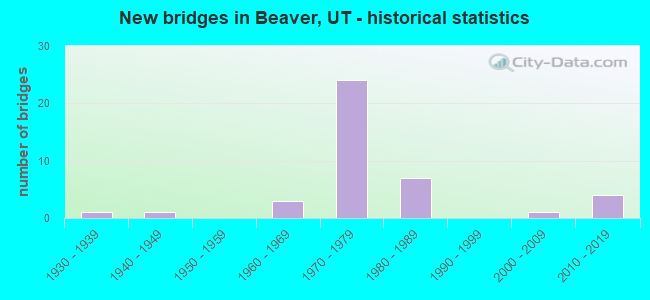
- New bridges - historical statistics
- 11930-1939
- 11940-1949
- 31960-1969
- 241970-1979
- 71980-1989
- 12000-2009
- 42010-2019

- Reconstructed bridges - Historical Statistics
- 11960-1969
- 11970-1979
- 01980-1989
- 01990-1999
- 02000-2009
- 12010-2019


- Bridge Condition - Deck
- 4.3%Very good
- 21.7%Good
- 65.2%Satisfactory
- 4.3%Fair
- 4.3%Poor

- Bridge Condition - Superstructure
- 13.0%Very good
- 39.1%Good
- 39.1%Satisfactory
- 8.7%Fair

- Bridge Condition - Substructure
- 34.8%Good
- 60.9%Satisfactory
- 4.3%Fair

- Bridge Condition - Channel
- 15.4%Very good
- 38.5%Good
- 30.8%Satisfactory
- 15.4%Fair

- Bridge Condition - Culverts
- 60.0%Satisfactory
- 40.0%Fair
Find on map >> Show street view
Structure Number: 1001C, Location: 0.25 MILES SE. OF BEAVER (Lat: 38.266308, Lng: -112.632678), Route carried "on" structure: County highway , Year Built: 1945, Status: Open, Structure Length: 0.91m (2.99ft), Average Daily Traffic: 30 (year 2020), Average Future Daily Traffic: 40 (year 2040), Design Load: H 20, Features Intersected: BEAVER RIVER, Facility Carried by Structure: COUNTY ROAD
Minimum Vertical Clearance: 30+ m (98+ ft), Kilometerpoint: 0.199, Lanes on structure: 1, Owner: County Highway Agency, Approaching Roadway Width: 4.8m (15.7ft), Skew: 1 degrees, Material/Design: Steel, Design/Construction: Stringer/Multi-beam, Number Of Spans In Main Unit: 1, Length of Maximum Span: 7.3m (24.0ft), Curb-To-Curb Width: 4.8m (15.7ft), Out-to-Out Width: 4.8m (15.7ft)
Condition: Deck: Fair, Superstructure: Fair, Substructure: Satisfactory, Channel: Satisfactory, Operating Rating: 36.9 metric tons, Method Used To Determine Operating Rating: Load Factor (LF) rating reported by rating factor (RF) method using MS18 loading, Inventory Rating: 19.4 metric tons, Method Used To Determine Inventory Rating: Load and Resistance Factor Rating (LRFR) rating reported by rating factor(RF) method using HL-93 loadings, Structural Evaluation: Somewhat better than minimum adequacy, Deck Geometry: Equal to present desirable criteria, Waterway Adequacy: Meets minimum limits, Approach Roadway Alignment: Equal to present minimum criteria, Length Of Structure Improvement: 0.03m (0.10ft), Designated Inspection Frequency: Every 24 months, Inspection Date: March 2020, Deck Structure Type: Corrugated Steel, Wearing Surface/Protective System: Wearing Surface: Bituminous
Find on map >> Show street view
Structure Number: 1002F, Location: 1.5 MILES SE. OF BEAVER (Lat: 38.272300, Lng: -112.613600), Route carried "on" structure: County highway , Year Built: 1985, Status: Open, Structure Length: 0.82m (2.69ft), Average Daily Traffic: 50 (year 2020), Average Future Daily Traffic: 61 (year 2040), Design Load: HS 20+Mod, Features Intersected: BEAVER RIVER, Facility Carried by Structure: HOLDAWAY LANE
Minimum Vertical Clearance: 30+ m (98+ ft), Kilometerpoint: 0.067, Lanes on structure: 2, Owner: City or Municipal Highway Agency, Approaching Roadway Width: 5.2m (17.1ft), Material/Design: Prestressed concrete, Design/Construction: Tee Beam, Number Of Spans In Main Unit: 1, Length of Maximum Span: 7.3m (24.0ft), Curb-To-Curb Width: 5.2m (17.1ft), Out-to-Out Width: 6.1m (20.0ft)
Condition: Deck: Good, Superstructure: Good, Substructure: Good, Channel: Very good, Operating Rating: 32.4 metric tons, Method Used To Determine Operating Rating: Load and Resistance Factor Rating (LRFR) rating reported by rating factor(RF) method using HL-93 loadings, Inventory Rating: 20.1 metric tons, Method Used To Determine Inventory Rating: Load and Resistance Factor Rating (LRFR) rating reported by rating factor(RF) method using HL-93 loadings, Structural Evaluation: Somewhat better than minimum adequacy, Waterway Adequacy: Equal to present minimum criteria, Approach Roadway Alignment: Equal to present minimum criteria, Designated Inspection Frequency: Every 24 months, Inspection Date: March 2020, Deck Structure Type: Concrete Precast Panels, Wearing Surface/Protective System: Wearing Surface: Gravel
Find on map >> Show street view
Structure Number: 1005F, Location: 0.5 MILE S. OF GREENVILLE (Lat: 38.250919, Lng: -112.713683), Route carried "on" structure: County highway 1006, Year Built: 1985, Status: Open, Structure Length: 1.14m (3.74ft), Average Daily Traffic: 350 (year 2020), Average Future Daily Traffic: 438 (year 2040), Design Load: HS 20+Mod, Features Intersected: BEAVER RIVER, Facility Carried by Structure: COUNTY ROAD
Minimum Vertical Clearance: 30+ m (98+ ft), Kilometerpoint: 9.185, Lanes on structure: 1, Owner: County Highway Agency, Approaching Roadway Width: 5.4m (17.7ft), Material/Design: Prestressed concrete, Design/Construction: Tee Beam, Number Of Spans In Main Unit: 1, Length of Maximum Span: 11.0m (36.1ft), Curb-To-Curb Width: 5.4m (17.7ft), Out-to-Out Width: 6.0m (19.7ft)
Condition: Deck: Good, Superstructure: Good, Substructure: Good, Channel: Good, Operating Rating: 32.4 metric tons, Method Used To Determine Operating Rating: Load and Resistance Factor Rating (LRFR) rating reported by rating factor(RF) method using HL-93 loadings, Inventory Rating: 21.7 metric tons, Method Used To Determine Inventory Rating: Load and Resistance Factor Rating (LRFR) rating reported by rating factor(RF) method using HL-93 loadings, Structural Evaluation: Equal to present minimum criteria, Deck Geometry: High priority of replacement, Waterway Adequacy: Equal to present minimum criteria, Approach Roadway Alignment: Better than present minimum criteria, Designated Inspection Frequency: Every 24 months, Inspection Date: March 2020, Deck Structure Type: Other, Wearing Surface/Protective System: Wearing Surface: Monolithic Concrete
Find on map >> Show street view
Structure Number: 1009E, Location: NORTH SIDE OF BEAVER (Lat: 38.297600, Lng: -112.648500), Route carried "on" structure: City street 1014, Year Built: 1982, Status: Open, Structure Length: 0.90m (2.95ft), Average Daily Traffic: 350 (year 2020), Average Future Daily Traffic: 438 (year 2040), Design Load: HS 20, Features Intersected: NORTH CREEK, Facility Carried by Structure: 400 WEST
Minimum Vertical Clearance: 30+ m (98+ ft), Kilometerpoint: 0.577, Lanes on structure: 2, Owner: City or Municipal Highway Agency, Approaching Roadway Width: 9.1m (29.9ft), Skew: 4 degrees, Material/Design: Concrete continuous, Design/Construction: Culvert, Number Of Spans In Main Unit: 2, Length of Maximum Span: 4.7m (15.4ft), Curb-To-Curb Width: 9.1m (29.9ft), Out-to-Out Width: 14.1m (46.3ft)
Condition: Channel: Good, Culverts: Fair, Operating Rating: 33.4 metric tons, Method Used To Determine Operating Rating: Load and Resistance Factor Rating (LRFR) rating reported by rating factor(RF) method using HL-93 loadings, Inventory Rating: 23.3 metric tons, Method Used To Determine Inventory Rating: Load and Resistance Factor Rating (LRFR) rating reported by rating factor(RF) method using HL-93 loadings, Structural Evaluation: Somewhat better than minimum adequacy, Deck Geometry: Equal to present minimum criteria, Waterway Adequacy: Somewhat better than minimum adequacy, Approach Roadway Alignment: Equal to present desirable criteria, Designated Inspection Frequency: Every 24 months, Inspection Date: March 2020
Find on map >> Show street view
Structure Number: 1010C, Location: 0.5 MILE SW. OF BEAVER GC (Lat: 38.276061, Lng: -112.601497), Route carried "on" structure: City street , Year Built: 1935, Status: Posted for load, Structure Length: 0.89m (2.92ft), Average Daily Traffic: 100 (year 2020), Average Future Daily Traffic: 120 (year 2040), Design Load: HS 15, Features Intersected: BEAVER RIVER, Facility Carried by Structure: NAVAJO TRAIL
Minimum Vertical Clearance: 30+ m (98+ ft), Kilometerpoint: 0.266, Lanes on structure: 1, Owner: County Highway Agency, Approaching Roadway Width: 4.7m (15.4ft), Material/Design: Steel, Design/Construction: Stringer/Multi-beam, Number Of Spans In Main Unit: 1, Length of Maximum Span: 8.6m (28.2ft), Curb-To-Curb Width: 4.7m (15.4ft), Out-to-Out Width: 4.9m (16.1ft)
Condition: Deck: Poor, Superstructure: Fair, Substructure: Satisfactory, Channel: Good, Operating Rating: 2.9 metric tons, Method Used To Determine Operating Rating: Load Factor (LF) rating reported by rating factor (RF) method using MS18 loading, Inventory Rating: 1.9 metric tons, Method Used To Determine Inventory Rating: Load Factor (LF) rating reported by rating factor (RF) method using MS18 loading, Structural Evaluation: High priority of replacement, Deck Geometry: Better than present minimum criteria, Waterway Adequacy: Equal to present minimum criteria, Approach Roadway Alignment: Meets minimum limits, Bridge Posting: Required (Relationship of Operating Rating to Maximum Legal Load: > 39.9% below), Designated Inspection Frequency: Every 24 months, Inspection Date: March 2020, Deck Structure Type: Wood or Timber, Wearing Surface/Protective System: Wearing Surface: Wood or Timber
Find on map >> Show street view
Structure Number: 1011E, Location: 1 MILE NORTH OF BEAVER (Lat: 38.306300, Lng: -112.639000), Route carried "on" structure: County highway 1016, Year Built: 1985, Status: Open, Structure Length: 0.97m (3.18ft), Average Daily Traffic: 1,652 (year 2020), Average Future Daily Traffic: 2,065 (year 2040), Design Load: HS 20+Mod, Features Intersected: NORTH CREEK, Facility Carried by Structure: COUNTY ROAD FA#357
Minimum Vertical Clearance: 30+ m (98+ ft), Kilometerpoint: 1.902, Lanes on structure: 2, Owner: County Highway Agency, Approaching Roadway Width: 7.3m (24.0ft), Skew: 6 degrees, Material/Design: Concrete, Design/Construction: Culvert, Number Of Spans In Main Unit: 1, Length of Maximum Span: 6.4m (21.0ft), Curb-To-Curb Width: 7.3m (24.0ft), Out-to-Out Width: 11.0m (36.1ft)
Condition: Channel: Good, Culverts: Satisfactory, Operating Rating: 32.4 metric tons, Method Used To Determine Operating Rating: Load and Resistance Factor Rating (LRFR) rating reported by rating factor(RF) method using HL-93 loadings, Inventory Rating: 19.4 metric tons, Method Used To Determine Inventory Rating: Load and Resistance Factor Rating (LRFR) rating reported by rating factor(RF) method using HL-93 loadings, Structural Evaluation: Somewhat better than minimum adequacy, Deck Geometry: Meets minimum limits, Waterway Adequacy: Better than present minimum criteria, Approach Roadway Alignment: Equal to present desirable criteria, Designated Inspection Frequency: Every 24 months, Inspection Date: March 2020, Deck Structure Type: Concrete Cast-file-Place, Wearing Surface/Protective System: Wearing Surface: Bituminous
Find on map >> Show street view
Structure Number: 1012V, Location: 1 MILE EAST OF GREENVILLE (Lat: 38.254561, Lng: -112.701394), Route carried "on" structure: County highway 1004, Year Built: 1985, Status: Open, Structure Length: 0.68m (2.23ft), Average Daily Traffic: 350 (year 2020), Average Future Daily Traffic: 438 (year 2040), Design Load: HL 93, Features Intersected: NORTH CREEK, Facility Carried by Structure: CO.-CREEK BED ROAD
Minimum Vertical Clearance: 30+ m (98+ ft), Kilometerpoint: 4.927, Lanes on structure: 1, Owner: County Highway Agency, Approaching Roadway Width: 4.3m (14.1ft), Skew: 3 degrees, Material/Design: Steel, Design/Construction: Culvert, Number Of Spans In Main Unit: 2, Length of Maximum Span: 4.1m (13.5ft)
Condition: Channel: Fair, Culverts: Fair, Operating Rating: 60.3 metric tons, Method Used To Determine Operating Rating: Load and Resistance Factor Rating (LRFR) rating reported by rating factor(RF) method using HL-93 loadings, Inventory Rating: 46.3 metric tons, Method Used To Determine Inventory Rating: Load and Resistance Factor Rating (LRFR) rating reported by rating factor(RF) method using HL-93 loadings, Structural Evaluation: Somewhat better than minimum adequacy, Waterway Adequacy: Meets minimum limits, Approach Roadway Alignment: Equal to present minimum criteria, Designated Inspection Frequency: Every 24 months, Inspection Date: March 2020
Find on map >> Show street view
Structure Number: C 571, Location: 2.2 MI.NO.SO.BEAVER INT. (Lat: 38.266497, Lng: -112.650761), Route carried "on" structure: County highway 1004, Year Built: 1970, Status: Open, Structure Length: 6.86m (22.51ft), Average Daily Traffic: 350 (year 2020), Truck Traffic: 27%, Average Future Daily Traffic: 438 (year 2040), Design Load: HS 20+Mod, Features Intersected: I-15 (SR-15) NB and SB, Facility Carried by Structure: 600 S. STREET
Minimum Vertical Clearance: 30+ m (98+ ft), Kilometerpoint: 10.028, Lanes on structure: 2, Lanes under structure: 4, Owner: State Highway Agency, Approaching Roadway Width: 8.5m (27.9ft), Material/Design: Steel continuous, Design/Construction: Stringer/Multi-beam, Number Of Spans In Main Unit: 2, Length of Maximum Span: 34.0m (111.5ft), Curb-To-Curb Width: 8.5m (27.9ft), Out-to-Out Width: 9.6m (31.5ft)
Condition: Deck: Satisfactory, Superstructure: Satisfactory, Substructure: Satisfactory, Operating Rating: 49.6 metric tons, Method Used To Determine Operating Rating: Load and Resistance Factor Rating (LRFR) rating reported by rating factor(RF) method using HL-93 loadings, Inventory Rating: 40.5 metric tons, Method Used To Determine Inventory Rating: Load Factor (LF) rating reported by rating factor (RF) method using MS18 loading, Structural Evaluation: Equal to present minimum criteria, Deck Geometry: Equal to present minimum criteria, Underclear: Equal to present minimum criteria, Approach Roadway Alignment: Equal to present minimum criteria, Designated Inspection Frequency: Every 24 months, Inspection Date: Febuary 2021, Deck Structure Type: Concrete Cast-file-Place, Wearing Surface/Protective System: Wearing Surface: Monolithic Concrete
Find on map >> Show street view
Structure Number: C 572, Location: SOUTH BEAVER INTERCHANGE (Lat: 38.249272, Lng: -112.650539), Route carried "on" structure: State highway 160, Year Built: 1970, Status: Open, Structure Length: 7.25m (23.79ft), Average Daily Traffic: 3,742 (year 2020), Truck Traffic: 30%, Average Future Daily Traffic: 4,678 (year 2040), Design Load: HS 20+Mod, Features Intersected: I-15 (SR-15) NBL & S
Minimum Vertical Clearance: 30+ m (98+ ft), Kilometerpoint: 0.130, Lanes on structure: 2, Lanes under structure: 4, Owner: State Highway Agency, Approaching Roadway Width: 12.2m (40.0ft), Material/Design: Steel continuous, Design/Construction: Stringer/Multi-beam, Number Of Spans In Main Unit: 2, Length of Maximum Span: 35.7m (117.1ft), Curb-To-Curb Width: 12.2m (40.0ft), Out-to-Out Width: 13.2m (43.3ft)
Condition: Deck: Satisfactory, Superstructure: Satisfactory, Substructure: Satisfactory, Operating Rating: 46.3 metric tons, Method Used To Determine Operating Rating: Load and Resistance Factor Rating (LRFR) rating reported by rating factor(RF) method using HL-93 loadings, Inventory Rating: 34.7 metric tons, Method Used To Determine Inventory Rating: Load Factor (LF) rating reported by rating factor (RF) method using MS18 loading, Structural Evaluation: Equal to present minimum criteria, Deck Geometry: Equal to present minimum criteria, Underclear: Equal to present minimum criteria, Approach Roadway Alignment: Equal to present desirable criteria, Designated Inspection Frequency: Every 24 months, Inspection Date: Febuary 2021, Deck Structure Type: Concrete Cast-file-Place, Wearing Surface/Protective System: Wearing Surface: Bituminous, Membrane: Preformed Fabric
Find on map >> Show street view
Structure Number: D 733, Location: 0.8 MI.NO.NO.BEAVER INTER (Lat: 38.304850, Lng: -112.652997), Route carried "on" structure: County highway 1014, Year Built: 1965, Status: Open, Structure Length: 6.32m (20.73ft), Average Daily Traffic: 350 (year 2020), Average Future Daily Traffic: 438 (year 2040), Design Load: HS 20+Mod, Features Intersected: I-15 (SR-15) N&SBL, Facility Carried by Structure: CO.RD.NO.OF BEAVER
Minimum Vertical Clearance: 30+ m (98+ ft), Kilometerpoint: 1.731, Lanes on structure: 2, Lanes under structure: 4, Owner: State Highway Agency, Approaching Roadway Width: 7.3m (24.0ft), Material/Design: Concrete continuous, Design/Construction: Tee Beam, Number Of Spans In Main Unit: 4, Length of Maximum Span: 21.4m (70.2ft), Curb or Sidewalk Widths: Left: 0.6m (2.0ft), Right: 0.6m (2.0ft), Curb-To-Curb Width: 7.3m (24.0ft), Out-to-Out Width: 9.1m (29.9ft)
Condition: Deck: Satisfactory, Superstructure: Good, Substructure: Satisfactory, Operating Rating: 56.7 metric tons, Method Used To Determine Operating Rating: Load and Resistance Factor Rating (LRFR) rating reported by rating factor(RF) method using HL-93 loadings, Inventory Rating: 51.5 metric tons, Method Used To Determine Inventory Rating: Load Factor (LF) rating reported by rating factor (RF) method using MS18 loading, Structural Evaluation: Equal to present minimum criteria, Deck Geometry: Somewhat better than minimum adequacy, Underclear: Somewhat better than minimum adequacy, Approach Roadway Alignment: Equal to present desirable criteria, Designated Inspection Frequency: Every 24 months, Inspection Date: Febuary 2021, Deck Structure Type: Concrete Cast-file-Place, Wearing Surface/Protective System: Wearing Surface: Monolithic Concrete
Find on map >> Show street view
Structure Number: E1785, Location: AT NO.BEAVER INTERCHANGE (Lat: 38.296228, Lng: -112.651150), Route carried "on" structure: Interstate 15, Year Built: 1964, Year Reconstructed: 1974, Status: Open, Structure Length: 0.69m (2.26ft), Average Daily Traffic: 20,576 (year 2020), Truck Traffic: 30%, Average Future Daily Traffic: 25,720 (year 2040), Design Load: HS 20+Mod, Features Intersected: NORTH WASH
Minimum Vertical Clearance: 30+ m (98+ ft), Kilometerpoint: 180.679, Lanes on structure: 6, Base Highway Network: Yes, Owner: State Highway Agency, Approaching Roadway Width: 12.3m (40.4ft), Skew: 22 degrees, Material/Design: Concrete continuous, Design/Construction: Culvert, Number Of Spans In Main Unit: 2, Length of Maximum Span: 3.4m (11.2ft), Curb-To-Curb Width: 43.0m (141.1ft), Out-to-Out Width: 81.7m (268.0ft)
Condition: Channel: Fair, Culverts: Satisfactory, Operating Rating: 32.4 metric tons, Method Used To Determine Operating Rating: Load Factor (LF) rating reported by rating factor (RF) method using MS18 loading, Inventory Rating: 15.6 metric tons, Method Used To Determine Inventory Rating: Load Factor (LF) rating reported by rating factor (RF) method using MS18 loading, Structural Evaluation: High priority of corrective action, Deck Geometry: Superior to present desirable criteria, Waterway Adequacy: Equal to present minimum criteria, Approach Roadway Alignment: Equal to present desirable criteria, Designated Inspection Frequency: Every 24 months, Inspection Date: Febuary 2021
Find on map >> Show street view
Structure Number: F 519, Location: 4.7 MILES EAST OF BEAVER (Lat: 38.277656, Lng: -112.559761), Route carried "on" structure: State highway 153, Year Built: 1984, Status: Open, Structure Length: 0.97m (3.18ft), Average Daily Traffic: 260 (year 2020), Truck Traffic: 33%, Average Future Daily Traffic: 325 (year 2040), Design Load: HS 20+Mod, Features Intersected: BEAVER RIVER
Minimum Vertical Clearance: 30+ m (98+ ft), Kilometerpoint: 7.631, Lanes on structure: 2, Owner: State Highway Agency, Approaching Roadway Width: 10.0m (32.8ft), Skew: 6 degrees, Material/Design: Prestressed concrete, Design/Construction: Tee Beam, Number Of Spans In Main Unit: 1, Length of Maximum Span: 9.7m (31.8ft), Curb-To-Curb Width: 10.0m (32.8ft), Out-to-Out Width: 11.1m (36.4ft)
Condition: Deck: Satisfactory, Superstructure: Good, Substructure: Satisfactory, Channel: Satisfactory, Operating Rating: 49.2 metric tons, Method Used To Determine Operating Rating: Load and Resistance Factor Rating (LRFR) rating reported by rating factor(RF) method using HL-93 loadings, Inventory Rating: 33.0 metric tons, Method Used To Determine Inventory Rating: Load Factor (LF) rating reported by rating factor (RF) method using MS18 loading, Structural Evaluation: Equal to present minimum criteria, Deck Geometry: Better than present minimum criteria, Waterway Adequacy: Equal to present minimum criteria, Approach Roadway Alignment: Equal to present desirable criteria, Designated Inspection Frequency: Every 24 months, Inspection Date: Febuary 2021, Deck Structure Type: Concrete Precast Panels, Wearing Surface/Protective System: Wearing Surface: Bituminous, Membrane: Preformed Fabric
Find on map >> Show street view
Structure Number: F 732, Location: South Side of Beaver (Lat: 38.264531, Lng: -112.644614), Route carried "on" structure: State highway 160, Year Built: 2005, Status: Open, Structure Length: 1.95m (6.40ft), Average Daily Traffic: 3,742 (year 2020), Truck Traffic: 30%, Average Future Daily Traffic: 4,678 (year 2040), Design Load: HL 93, Features Intersected: BEAVER RIVER
Minimum Vertical Clearance: 30+ m (98+ ft), Kilometerpoint: 2.075, Lanes on structure: 2, Owner: State Highway Agency, Approaching Roadway Width: 13.4m (44.0ft), Material/Design: Prestressed concrete, Design/Construction: Stringer/Multi-beam, Number Of Spans In Main Unit: 1, Length of Maximum Span: 18.4m (60.4ft), Curb-To-Curb Width: 13.4m (44.0ft), Out-to-Out Width: 14.3m (46.9ft)
Condition: Deck: Satisfactory, Superstructure: Good, Substructure: Satisfactory, Channel: Good, Operating Rating: 38.2 metric tons, Method Used To Determine Operating Rating: Load and Resistance Factor Rating (LRFR) rating reported by rating factor(RF) method using HL-93 loadings, Inventory Rating: 37.9 metric tons, Method Used To Determine Inventory Rating: Load and Resistance Factor Rating (LRFR) rating reported by rating factor(RF) method using HL-93 loadings, Structural Evaluation: Equal to present minimum criteria, Deck Geometry: Better than present minimum criteria, Waterway Adequacy: Better than present minimum criteria, Approach Roadway Alignment: Equal to present desirable criteria, Designated Inspection Frequency: Every 24 months, Inspection Date: Febuary 2021, Deck Structure Type: Concrete Cast-file-Place, Wearing Surface/Protective System: Wearing Surface: Monolithic Concrete, Deck Protection: Epoxy Coated Reinforcing
Find on map >> Show street view
Structure Number: 1D 767, Location: WEST SIDE OF BEAVER (Lat: 38.273975, Lng: -112.650253), Route carried "on" structure: Interstate 15, Year Built: 1970, Status: Open, Structure Length: 3.21m (10.53ft), Average Daily Traffic: 19,656 (year 2020), Truck Traffic: 31%, Average Future Daily Traffic: 24,570 (year 2040), Design Load: HS 20+Mod, Features Intersected: SR-21 BEAVER CENTER ST.
Minimum Vertical Clearance: 30+ m (98+ ft), Kilometerpoint: 178.206, Lanes on structure: 2, Lanes under structure: 2, Base Highway Network: Yes, Owner: State Highway Agency, Approaching Roadway Width: 11.5m (37.7ft), Material/Design: Concrete continuous, Design/Construction: Tee Beam, Number Of Spans In Main Unit: 3, Length of Maximum Span: 12.3m (40.4ft), Curb-To-Curb Width: 11.5m (37.7ft), Out-to-Out Width: 12.5m (41.0ft)
Condition: Deck: Satisfactory, Superstructure: Satisfactory, Substructure: Fair, Operating Rating: 34.7 metric tons, Method Used To Determine Operating Rating: Load and Resistance Factor Rating (LRFR) rating reported by rating factor(RF) method using HL-93 loadings, Inventory Rating: 27.2 metric tons, Method Used To Determine Inventory Rating: Load Factor (LF) rating reported by rating factor (RF) method using MS18 loading, Structural Evaluation: Somewhat better than minimum adequacy, Deck Geometry: Somewhat better than minimum adequacy, Underclear: Meets minimum limits, Approach Roadway Alignment: Equal to present desirable criteria, Designated Inspection Frequency: Every 24 months, Inspection Date: Febuary 2021, Deck Structure Type: Concrete Cast-file-Place, Wearing Surface/Protective System: Wearing Surface: Bituminous, Membrane: Preformed Fabric
Find on map >> Show street view
Structure Number: 1F 132, Location: NORTH BEAVER INTERCHANGE (Lat: 38.293386, Lng: -112.650767), Route carried "on" structure: Interstate 15, Year Built: 1970, Status: Open, Structure Length: 3.19m (10.47ft), Average Daily Traffic: 20,576 (year 2020), Truck Traffic: 30%, Average Future Daily Traffic: 25,720 (year 2040), Design Load: HS 20+Mod, Features Intersected: SR-160
Minimum Vertical Clearance: 30+ m (98+ ft), Kilometerpoint: 180.361, Lanes on structure: 2, Lanes under structure: 2, Base Highway Network: Yes, Owner: State Highway Agency, Approaching Roadway Width: 12.8m (42.0ft), Material/Design: Prestressed concrete, Design/Construction: Stringer/Multi-beam, Number Of Spans In Main Unit: 1, Length of Maximum Span: 30.6m (100.4ft), Curb-To-Curb Width: 12.8m (42.0ft), Out-to-Out Width: 13.5m (44.3ft)
Condition: Deck: Satisfactory, Superstructure: Good, Substructure: Satisfactory, Operating Rating: 52.2 metric tons, Method Used To Determine Operating Rating: Load and Resistance Factor Rating (LRFR) rating reported by rating factor(RF) method using HL-93 loadings, Inventory Rating: 27.9 metric tons, Method Used To Determine Inventory Rating: Load Factor (LF) rating reported by rating factor (RF) method using MS18 loading, Structural Evaluation: Equal to present minimum criteria, Deck Geometry: Equal to present desirable criteria, Underclear: Somewhat better than minimum adequacy, Approach Roadway Alignment: Equal to present desirable criteria, Designated Inspection Frequency: Every 24 months, Inspection Date: Febuary 2021, Deck Structure Type: Concrete Cast-file-Place, Wearing Surface/Protective System: Wearing Surface: Bituminous, Membrane: Preformed Fabric
Find on map >> Show street view
Structure Number: 1F 176, Location: WEST SIDE OF BEAVER (Lat: 38.281719, Lng: -112.650386), Route carried "on" structure: Interstate 15, Year Built: 1970, Status: Open, Structure Length: 2.60m (8.53ft), Average Daily Traffic: 19,656 (year 2020), Truck Traffic: 31%, Average Future Daily Traffic: 24,570 (year 2040), Design Load: HS 20+Mod, Features Intersected: 600 NORTH STREET-BEAVER
Minimum Vertical Clearance: 30+ m (98+ ft), Kilometerpoint: 179.066, Lanes on structure: 2, Lanes under structure: 2, Base Highway Network: Yes, Owner: State Highway Agency, Approaching Roadway Width: 11.5m (37.7ft), Material/Design: Prestressed concrete, Design/Construction: Stringer/Multi-beam, Number Of Spans In Main Unit: 1, Length of Maximum Span: 24.8m (81.4ft), Curb-To-Curb Width: 11.5m (37.7ft), Out-to-Out Width: 12.5m (41.0ft)
Condition: Deck: Satisfactory, Superstructure: Good, Substructure: Satisfactory, Operating Rating: 42.8 metric tons, Method Used To Determine Operating Rating: Load Factor (LF) rating reported by rating factor (RF) method using MS18 loading, Inventory Rating: 35.3 metric tons, Method Used To Determine Inventory Rating: Load Factor (LF) rating reported by rating factor (RF) method using MS18 loading, Structural Evaluation: Equal to present minimum criteria, Deck Geometry: Somewhat better than minimum adequacy, Underclear: Meets minimum limits, Approach Roadway Alignment: Equal to present desirable criteria, Designated Inspection Frequency: Every 24 months, Inspection Date: Febuary 2021, Deck Structure Type: Concrete Cast-file-Place, Wearing Surface/Protective System: Wearing Surface: Bituminous, Membrane: Preformed Fabric
Find on map >> Show street view
Structure Number: 1F 18, Location: 1.1 MI.NO.SO.BEAVER INTER (Lat: 38.264939, Lng: -112.650128), Route carried "on" structure: Interstate 15, Year Built: 1970, Status: Open, Structure Length: 1.76m (5.77ft), Average Daily Traffic: 19,656 (year 2020), Truck Traffic: 31%, Average Future Daily Traffic: 24,570 (year 2040), Design Load: HS 20+Mod, Features Intersected: BEAVER RIVER
Minimum Vertical Clearance: 30+ m (98+ ft), Kilometerpoint: 177.203, Lanes on structure: 2, Base Highway Network: Yes, Owner: State Highway Agency, Approaching Roadway Width: 11.5m (37.7ft), Material/Design: Prestressed concrete, Design/Construction: Stringer/Multi-beam, Number Of Spans In Main Unit: 1, Length of Maximum Span: 16.5m (54.1ft), Curb-To-Curb Width: 11.5m (37.7ft), Out-to-Out Width: 12.5m (41.0ft)
Condition: Deck: Satisfactory, Superstructure: Satisfactory, Substructure: Good, Channel: Satisfactory, Operating Rating: 35.6 metric tons, Method Used To Determine Operating Rating: Load and Resistance Factor Rating (LRFR) rating reported by rating factor(RF) method using HL-93 loadings, Inventory Rating: 23.0 metric tons, Method Used To Determine Inventory Rating: Load Factor (LF) rating reported by rating factor (RF) method using MS18 loading, Structural Evaluation: Somewhat better than minimum adequacy, Deck Geometry: Somewhat better than minimum adequacy, Waterway Adequacy: Equal to present minimum criteria, Approach Roadway Alignment: Equal to present desirable criteria, Designated Inspection Frequency: Every 24 months, Inspection Date: Febuary 2021, Deck Structure Type: Concrete Cast-file-Place, Wearing Surface/Protective System: Wearing Surface: Bituminous, Membrane: Preformed Fabric
Find on map >> Show street view
Structure Number: 1F 363N, Location: 7.9 MI.NO.BEAR VALLEY INT (Lat: 38.171219, Lng: -112.622564), Route carried "on" structure: Interstate 15, Year Built: 1975, Status: Open, Structure Length: 2.34m (7.68ft), Average Daily Traffic: 21,718 (year 2020), Truck Traffic: 32%, Average Future Daily Traffic: 27,148 (year 2040), Design Load: HS 20+Mod, Features Intersected: DEER CROSSING
Minimum Vertical Clearance: 30+ m (98+ ft), Kilometerpoint: 166.149, Lanes on structure: 2, Base Highway Network: Yes, Owner: State Highway Agency, Approaching Roadway Width: 12.5m (41.0ft), Material/Design: Prestressed concrete, Design/Construction: Stringer/Multi-beam, Number Of Spans In Main Unit: 1, Length of Maximum Span: 22.1m (72.5ft), Curb-To-Curb Width: 12.5m (41.0ft), Out-to-Out Width: 13.5m (44.3ft)
Condition: Deck: Satisfactory, Superstructure: Satisfactory, Substructure: Good, Operating Rating: 65.1 metric tons, Method Used To Determine Operating Rating: Load and Resistance Factor Rating (LRFR) rating reported by rating factor(RF) method using HL-93 loadings, Inventory Rating: 38.2 metric tons, Method Used To Determine Inventory Rating: Load Factor (LF) rating reported by rating factor (RF) method using MS18 loading, Structural Evaluation: Equal to present minimum criteria, Deck Geometry: Better than present minimum criteria, Approach Roadway Alignment: Equal to present desirable criteria, Designated Inspection Frequency: Every 24 months, Inspection Date: Febuary 2021, Deck Structure Type: Concrete Cast-file-Place, Wearing Surface/Protective System: Wearing Surface: Bituminous, Membrane: Preformed Fabric
Find on map >> Show street view
Structure Number: 1F 397, Location: 5 MI. S. of Beaver (Lat: 38.187372, Lng: -112.637633), Route carried "on" structure: Interstate 15, Year Built: 1975, Status: Open, Structure Length: 3.00m (9.84ft), Average Daily Traffic: 21,718 (year 2020), Truck Traffic: 32%, Average Future Daily Traffic: 27,148 (year 2040), Design Load: HS 20+Mod, Features Intersected: COUNTY ACCESS ROAD
Minimum Vertical Clearance: 30+ m (98+ ft), Kilometerpoint: 168.386, Lanes on structure: 2, Lanes under structure: 1, Base Highway Network: Yes, Owner: State Highway Agency, Approaching Roadway Width: 12.3m (40.4ft), Skew: 3 degrees, Material/Design: Prestressed concrete, Design/Construction: Stringer/Multi-beam, Number Of Spans In Main Unit: 1, Length of Maximum Span: 28.9m (94.8ft), Curb-To-Curb Width: 12.3m (40.4ft), Out-to-Out Width: 13.4m (44.0ft)
Condition: Deck: Good, Superstructure: Satisfactory, Substructure: Satisfactory, Operating Rating: 73.5 metric tons, Method Used To Determine Operating Rating: Load and Resistance Factor Rating (LRFR) rating reported by rating factor(RF) method using HL-93 loadings, Inventory Rating: 39.9 metric tons, Method Used To Determine Inventory Rating: Load Factor (LF) rating reported by rating factor (RF) method using MS18 loading, Structural Evaluation: Equal to present minimum criteria, Deck Geometry: Better than present minimum criteria, Underclear: High priority of corrective action, Approach Roadway Alignment: Equal to present desirable criteria, Designated Inspection Frequency: Every 24 months, Inspection Date: Febuary 2021, Deck Structure Type: Concrete Cast-file-Place, Wearing Surface/Protective System: Wearing Surface: Bituminous, Membrane: Preformed Fabric
Find on map >> Show street view
Structure Number: 1F 853, Location: 4.6 mi. N. of Beaver (Lat: 38.359311, Lng: -112.661194), Route carried "on" structure: Interstate 15, Year Built: 2013, Status: Open, Structure Length: 2.38m (7.81ft), Average Daily Traffic: 20,576 (year 2020), Truck Traffic: 30%, Average Future Daily Traffic: 25,720 (year 2040), Design Load: HL 93, Features Intersected: Co.Rd. W of MANDERFIELD
Minimum Vertical Clearance: 30+ m (98+ ft), Kilometerpoint: 187.735, Lanes on structure: 2, Lanes under structure: 2, Base Highway Network: Yes, Owner: State Highway Agency, Approaching Roadway Width: 12.8m (42.0ft), Material/Design: Prestressed concrete, Design/Construction: Stringer/Multi-beam, Number Of Spans In Main Unit: 1, Length of Maximum Span: 22.6m (74.1ft), Curb-To-Curb Width: 12.8m (42.0ft), Out-to-Out Width: 13.7m (44.9ft)
Condition: Deck: Very good, Superstructure: Very good, Substructure: Good, Operating Rating: 58.6 metric tons, Method Used To Determine Operating Rating: Load and Resistance Factor Rating (LRFR) rating reported by rating factor(RF) method using HL-93 loadings, Inventory Rating: 37.9 metric tons, Method Used To Determine Inventory Rating: Load and Resistance Factor Rating (LRFR) rating reported by rating factor(RF) method using HL-93 loadings, Structural Evaluation: Better than present minimum criteria, Deck Geometry: Equal to present desirable criteria, Underclear: High priority of corrective action, Approach Roadway Alignment: Equal to present desirable criteria, Designated Inspection Frequency: Every 24 months, Inspection Date: Febuary 2021, Deck Structure Type: Concrete Cast-file-Place, Wearing Surface/Protective System: Wearing Surface: Monolithic Concrete, Deck Protection: Epoxy Coated Reinforcing
Find on map >> Show street view
Structure Number: 3D 767, Location: WEST SIDE OF BEAVER (Lat: 38.274297, Lng: -112.650569), Route carried "on" structure: Interstate 15, Year Built: 1970, Status: Open, Structure Length: 3.21m (10.53ft), Average Daily Traffic: 19,656 (year 2020), Truck Traffic: 31%, Average Future Daily Traffic: 24,570 (year 2040), Design Load: HS 20+Mod, Features Intersected: SR-21 BEAVER CENTER ST.
Minimum Vertical Clearance: 30.18m (99.02ft), Kilometerpoint: 178.050, Lanes on structure: 2, Lanes under structure: 2, Base Highway Network: Yes, Owner: State Highway Agency, Approaching Roadway Width: 11.5m (37.7ft), Material/Design: Concrete continuous, Design/Construction: Tee Beam, Number Of Spans In Main Unit: 3, Length of Maximum Span: 12.3m (40.4ft), Curb-To-Curb Width: 11.5m (37.7ft), Out-to-Out Width: 12.6m (41.3ft)
Condition: Deck: Satisfactory, Superstructure: Satisfactory, Substructure: Satisfactory, Operating Rating: 34.7 metric tons, Method Used To Determine Operating Rating: Load and Resistance Factor Rating (LRFR) rating reported by rating factor(RF) method using HL-93 loadings, Inventory Rating: 27.2 metric tons, Method Used To Determine Inventory Rating: Load Factor (LF) rating reported by rating factor (RF) method using MS18 loading, Structural Evaluation: Equal to present minimum criteria, Deck Geometry: Somewhat better than minimum adequacy, Underclear: Meets minimum limits, Approach Roadway Alignment: Equal to present desirable criteria, Designated Inspection Frequency: Every 24 months, Inspection Date: Febuary 2021, Deck Structure Type: Concrete Cast-file-Place, Wearing Surface/Protective System: Wearing Surface: Bituminous, Membrane: Preformed Fabric
Find on map >> Show street view
Structure Number: 3E1973, Location: 1 Mi. S. of Beaver (Lat: 38.214450, Lng: -112.648419), Route carried "on" structure: Interstate 15, Year Built: 1975, Status: Open, Structure Length: 0.70m (2.30ft), Average Daily Traffic: 21,718 (year 2020), Truck Traffic: 32%, Average Future Daily Traffic: 27,148 (year 2040), Design Load: HS 20+Mod, Features Intersected: NEVERSHINE HOLLOW WASH
Minimum Vertical Clearance: 30+ m (98+ ft), Kilometerpoint: 171.402, Lanes on structure: 2, Base Highway Network: Yes, Owner: State Highway Agency, Approaching Roadway Width: 12.8m (42.0ft), Skew: 3 degrees, Material/Design: Concrete continuous, Design/Construction: Culvert, Number Of Spans In Main Unit: 2, Length of Maximum Span: 3.0m (9.8ft)
Condition: Channel: Very good, Culverts: Satisfactory, Operating Rating: 32.4 metric tons, Method Used To Determine Operating Rating: Load and Resistance Factor Rating (LRFR) rating reported by rating factor(RF) method using HL-93 loadings, Inventory Rating: 32.1 metric tons, Method Used To Determine Inventory Rating: Load Factor (LF) rating reported by rating factor (RF) method using MS18 loading, Structural Evaluation: Equal to present minimum criteria, Waterway Adequacy: Equal to present minimum criteria, Approach Roadway Alignment: Equal to present desirable criteria, Designated Inspection Frequency: Every 24 months, Inspection Date: Febuary 2021
Find on map >> Show street view
Structure Number: 3F 132, Location: NORTH BEAVER INTERCHANGE (Lat: 38.293733, Lng: -112.651128), Route carried "on" structure: Interstate 15, Year Built: 1970, Year Reconstructed: 1984, Status: Open, Structure Length: 3.19m (10.47ft), Average Daily Traffic: 19,656 (year 2020), Truck Traffic: 31%, Average Future Daily Traffic: 24,570 (year 2040), Design Load: HS 20+Mod, Features Intersected: SR-160, INTCHG. X-ROAD
Minimum Vertical Clearance: 30+ m (98+ ft), Kilometerpoint: 180.209, Lanes on structure: 2, Lanes under structure: 2, Base Highway Network: Yes, Owner: State Highway Agency, Approaching Roadway Width: 12.8m (42.0ft), Skew: 10 degrees, Material/Design: Prestressed concrete, Design/Construction: Stringer/Multi-beam, Number Of Spans In Main Unit: 1, Length of Maximum Span: 30.6m (100.4ft), Curb-To-Curb Width: 12.8m (42.0ft), Out-to-Out Width: 13.5m (44.3ft)
Condition: Deck: Good, Superstructure: Satisfactory, Substructure: Satisfactory, Operating Rating: 52.2 metric tons, Method Used To Determine Operating Rating: Load and Resistance Factor Rating (LRFR) rating reported by rating factor(RF) method using HL-93 loadings, Inventory Rating: 18.8 metric tons, Method Used To Determine Inventory Rating: Load Factor (LF) rating reported by rating factor (RF) method using MS18 loading, Structural Evaluation: Meets minimum limits, Deck Geometry: Equal to present desirable criteria, Underclear: Somewhat better than minimum adequacy, Approach Roadway Alignment: Equal to present desirable criteria, Designated Inspection Frequency: Every 24 months, Inspection Date: Febuary 2021, Deck Structure Type: Concrete Cast-file-Place, Wearing Surface/Protective System: Wearing Surface: Bituminous, Membrane: Preformed Fabric
Find on map >> Show street view
Structure Number: 3F 176, Location: WEST SIDE OF BEAVER (Lat: 38.281978, Lng: -112.650708), Route carried "on" structure: Interstate 15, Year Built: 1970, Status: Open, Structure Length: 2.60m (8.53ft), Average Daily Traffic: 19,656 (year 2020), Truck Traffic: 31%, Average Future Daily Traffic: 24,570 (year 2040), Design Load: HS 20+Mod, Features Intersected: 600 NORTH STREET-BEAVER
Minimum Vertical Clearance: 30+ m (98+ ft), Kilometerpoint: 178.903, Lanes on structure: 2, Lanes under structure: 2, Base Highway Network: Yes, Owner: State Highway Agency, Approaching Roadway Width: 11.5m (37.7ft), Skew: 10 degrees, Material/Design: Prestressed concrete, Design/Construction: Stringer/Multi-beam, Number Of Spans In Main Unit: 1, Length of Maximum Span: 24.8m (81.4ft), Curb-To-Curb Width: 11.5m (37.7ft), Out-to-Out Width: 12.5m (41.0ft)
Condition: Deck: Satisfactory, Superstructure: Good, Substructure: Good, Operating Rating: 42.8 metric tons, Method Used To Determine Operating Rating: Load Factor (LF) rating reported by rating factor (RF) method using MS18 loading, Inventory Rating: 35.3 metric tons, Method Used To Determine Inventory Rating: Load Factor (LF) rating reported by rating factor (RF) method using MS18 loading, Structural Evaluation: Better than present minimum criteria, Deck Geometry: Somewhat better than minimum adequacy, Underclear: Meets minimum limits, Approach Roadway Alignment: Equal to present desirable criteria, Designated Inspection Frequency: Every 24 months, Inspection Date: Febuary 2021, Deck Structure Type: Concrete Cast-file-Place, Wearing Surface/Protective System: Wearing Surface: Bituminous, Membrane: Preformed Fabric
Find on map >> Show street view
Structure Number: 3F 18, Location: 1.1 MI.NO.SO.BEAVER INTER (Lat: 38.265128, Lng: -112.650433), Route carried "on" structure: Interstate 15, Year Built: 1970, Status: Open, Structure Length: 1.76m (5.77ft), Average Daily Traffic: 19,656 (year 2020), Truck Traffic: 31%, Average Future Daily Traffic: 24,570 (year 2040), Design Load: HS 20+Mod, Features Intersected: BEAVER RIVER
Minimum Vertical Clearance: 30+ m (98+ ft), Kilometerpoint: 177.033, Lanes on structure: 2, Base Highway Network: Yes, Owner: State Highway Agency, Approaching Roadway Width: 11.5m (37.7ft), Material/Design: Prestressed concrete, Design/Construction: Stringer/Multi-beam, Number Of Spans In Main Unit: 1, Length of Maximum Span: 16.5m (54.1ft), Curb-To-Curb Width: 11.5m (37.7ft), Out-to-Out Width: 12.5m (41.0ft)
Condition: Deck: Satisfactory, Superstructure: Satisfactory, Substructure: Good, Channel: Satisfactory, Operating Rating: 35.6 metric tons, Method Used To Determine Operating Rating: Load and Resistance Factor Rating (LRFR) rating reported by rating factor(RF) method using HL-93 loadings, Inventory Rating: 35.3 metric tons, Method Used To Determine Inventory Rating: Load and Resistance Factor Rating (LRFR) rating reported by rating factor(RF) method using HL-93 loadings, Structural Evaluation: Equal to present minimum criteria, Deck Geometry: Somewhat better than minimum adequacy, Waterway Adequacy: Equal to present minimum criteria, Approach Roadway Alignment: Equal to present desirable criteria, Designated Inspection Frequency: Every 24 months, Inspection Date: Febuary 2021, Deck Structure Type: Concrete Cast-file-Place, Wearing Surface/Protective System: Wearing Surface: Bituminous, Membrane: Preformed Fabric
Find on map >> Show street view
Structure Number: 3F 363S, Location: 7.9 MI.NO.BEAR VALLEY INT (Lat: 38.171242, Lng: -112.623197), Route carried "on" structure: Interstate 15, Year Built: 1984, Year Reconstructed: 2015, Status: Open, Structure Length: 2.29m (7.51ft), Average Daily Traffic: 21,718 (year 2020), Truck Traffic: 32%, Average Future Daily Traffic: 27,148 (year 2040), Design Load: HL 93, Features Intersected: DEER CROSSING
Minimum Vertical Clearance: 30+ m (98+ ft), Kilometerpoint: 165.908, Lanes on structure: 3, Base Highway Network: Yes, Owner: State Highway Agency, Approaching Roadway Width: 18.2m (59.7ft), Skew: 1 degrees, Material/Design: Prestressed concrete, Design/Construction: Stringer/Multi-beam, Number Of Spans In Main Unit: 1, Length of Maximum Span: 22.1m (72.5ft), Curb-To-Curb Width: 18.2m (59.7ft), Out-to-Out Width: 19.1m (62.7ft)
Condition: Deck: Satisfactory, Superstructure: Good, Substructure: Satisfactory, Operating Rating: 40.5 metric tons, Method Used To Determine Operating Rating: Load and Resistance Factor Rating (LRFR) rating reported by rating factor(RF) method using HL-93 loadings, Inventory Rating: 36.9 metric tons, Method Used To Determine Inventory Rating: Load Factor (LF) rating reported by rating factor (RF) method using MS18 loading, Structural Evaluation: Equal to present minimum criteria, Deck Geometry: Better than present minimum criteria, Approach Roadway Alignment: Equal to present desirable criteria, Designated Inspection Frequency: Every 24 months, Inspection Date: Febuary 2021, Deck Structure Type: Concrete Cast-file-Place, Wearing Surface/Protective System: Wearing Surface: Bituminous, Membrane: Preformed Fabric, Deck Protection: Epoxy Coated Reinforcing
Find on map >> Show street view
Structure Number: 3F 397, Location: 5 MI.SO.SO.BEAVER INTCHG. (Lat: 38.187575, Lng: -112.638444), Route carried "on" structure: Interstate 15, Year Built: 1975, Status: Open, Structure Length: 3.00m (9.84ft), Average Daily Traffic: 21,718 (year 2020), Truck Traffic: 32%, Average Future Daily Traffic: 27,148 (year 2040), Design Load: HS 20+Mod, Features Intersected: COUNTY ACCESS ROAD
Minimum Vertical Clearance: 30+ m (98+ ft), Kilometerpoint: 168.170, Lanes on structure: 2, Lanes under structure: 2, Base Highway Network: Yes, Owner: State Highway Agency, Approaching Roadway Width: 12.3m (40.4ft), Skew: 3 degrees, Material/Design: Prestressed concrete, Design/Construction: Stringer/Multi-beam, Number Of Spans In Main Unit: 1, Length of Maximum Span: 28.9m (94.8ft), Curb-To-Curb Width: 12.3m (40.4ft), Out-to-Out Width: 13.4m (44.0ft)
Condition: Deck: Satisfactory, Superstructure: Very good, Substructure: Satisfactory, Operating Rating: 36.3 metric tons, Method Used To Determine Operating Rating: Load and Resistance Factor Rating (LRFR) rating reported by rating factor(RF) method using HL-93 loadings, Inventory Rating: 34.3 metric tons, Method Used To Determine Inventory Rating: Load and Resistance Factor Rating (LRFR) rating reported by rating factor(RF) method using HL-93 loadings, Structural Evaluation: Equal to present minimum criteria, Deck Geometry: Better than present minimum criteria, Underclear: High priority of corrective action, Approach Roadway Alignment: Equal to present desirable criteria, Designated Inspection Frequency: Every 24 months, Inspection Date: Febuary 2021, Deck Structure Type: Concrete Cast-file-Place, Wearing Surface/Protective System: Wearing Surface: Bituminous, Membrane: Preformed Fabric
Find on map >> Show street view
Structure Number: 3F 853, Location: 4.6 mi. north of Beaver (Lat: 38.359686, Lng: -112.661581), Route carried "on" structure: Interstate 15, Year Built: 2013, Status: Open, Structure Length: 2.38m (7.81ft), Average Daily Traffic: 20,576 (year 2020), Truck Traffic: 30%, Average Future Daily Traffic: 25,720 (year 2040), Design Load: HL 93, Features Intersected: CO.RD.W.from MANDERFIELD
Minimum Vertical Clearance: 30+ m (98+ ft), Kilometerpoint: 187.586, Lanes on structure: 2, Lanes under structure: 2, Base Highway Network: Yes, Owner: State Highway Agency, Approaching Roadway Width: 12.8m (42.0ft), Skew: 10 degrees, Material/Design: Prestressed concrete, Design/Construction: Stringer/Multi-beam, Number Of Spans In Main Unit: 1, Length of Maximum Span: 22.6m (74.1ft), Curb-To-Curb Width: 12.8m (42.0ft), Out-to-Out Width: 13.7m (44.9ft)
Condition: Deck: Good, Superstructure: Very good, Substructure: Good, Operating Rating: 57.3 metric tons, Method Used To Determine Operating Rating: Load and Resistance Factor Rating (LRFR) rating reported by rating factor(RF) method using HL-93 loadings, Inventory Rating: 32.4 metric tons, Method Used To Determine Inventory Rating: Load and Resistance Factor Rating (LRFR) rating reported by rating factor(RF) method using HL-93 loadings, Structural Evaluation: Better than present minimum criteria, Deck Geometry: Equal to present desirable criteria, Underclear: High priority of corrective action, Approach Roadway Alignment: Equal to present desirable criteria, Designated Inspection Frequency: Every 24 months, Inspection Date: Febuary 2021, Deck Structure Type: Concrete Cast-file-Place, Wearing Surface/Protective System: Wearing Surface: Latex Concrete, Deck Protection: Epoxy Coated Reinforcing
Find on map >> Show street view
Structure Number: C 571, Location: 2.2 MI.NO.SO.BEAVER INT. (Lat: 38.266497, Lng: -112.650761), Route carried "under" structure: Interstate 15, Year Built: 1970, Structure Length: 0. m, Average Daily Traffic: 19,656 (year 2020), Truck Traffic: 31%, Features Intersected: I-15 (SR-15) NB and SB, Facility Carried by Structure: 600 S. STREET
Minimum Vertical Clearance: 5.09m (16.70ft), Kilometerpoint: 176.912, Lanes on structure: 2, Lanes under structure: 4, Material/Design: Steel continuous, Design/Construction: Stringer/Multi-beam, Length of Maximum Span: 34.0m (111.5ft)
Find on map >> Show street view
Structure Number: C 572, Location: SOUTH BEAVER INTERCHANGE (Lat: 38.249272, Lng: -112.650539), Route carried "under" structure: Interstate 15, Year Built: 1970, Structure Length: 0. m, Average Daily Traffic: 21,718 (year 2020), Truck Traffic: 32%, Features Intersected: I-15 (SR-15) NBL & S, Facility Carried by Structure: SR-160
Minimum Vertical Clearance: 5.03m (16.50ft), Kilometerpoint: 175.008, Lanes on structure: 2, Lanes under structure: 4, Material/Design: Steel continuous, Design/Construction: Stringer/Multi-beam, Length of Maximum Span: 35.7m (117.1ft)
Find on map >> Show street view
Structure Number: D 733, Location: 0.8 MI.NO.NO.BEAVER INTER (Lat: 38.304850, Lng: -112.652997), Route carried "under" structure: Interstate 15, Year Built: 1965, Structure Length: 0. m, Average Daily Traffic: 20,576 (year 2020), Truck Traffic: 30%, Features Intersected: I-15 (SR-15) N&SBL, Facility Carried by Structure: CO.RD.NO.OF BEAVER
Minimum Vertical Clearance: 5.15m (16.90ft), Kilometerpoint: 181.170, Lanes on structure: 2, Lanes under structure: 4, Material/Design: Concrete continuous, Design/Construction: Tee Beam, Length of Maximum Span: 21.4m (70.2ft)
Find on map >> Show street view
Structure Number: 1D 767, Location: WEST SIDE OF BEAVER (Lat: 38.273975, Lng: -112.650253), Route carried "under" structure: State highway 21, Year Built: 1970, Structure Length: 0. m, Average Daily Traffic: 1,709 (year 2020), Truck Traffic: 8%, Features Intersected: SR-21 BEAVER CENTER ST., Facility Carried by Structure: I-15 (SR-15) NBL
Minimum Vertical Clearance: 4.72m (15.49ft), Kilometerpoint: 172.348, Lanes on structure: 2, Lanes under structure: 2, Material/Design: Concrete continuous, Design/Construction: Tee Beam, Length of Maximum Span: 12.3m (40.4ft)
Find on map >> Show street view
Structure Number: 1F 132, Location: NORTH BEAVER INTERCHANGE (Lat: 38.293386, Lng: -112.650767), Route carried "under" structure: State highway 160, Year Built: 1970, Structure Length: 0. m, Average Daily Traffic: 4,531 (year 2020), Truck Traffic: 27%, Features Intersected: SR-160, Facility Carried by Structure: I-15 (SR-15) NBL
Minimum Vertical Clearance: 5.07m (16.63ft), Kilometerpoint: 6.014, Lanes on structure: 2, Lanes under structure: 2, Material/Design: Prestressed concrete, Design/Construction: Stringer/Multi-beam, Length of Maximum Span: 30.6m (100.4ft)
Find on map >> Show street view
Structure Number: 1F 176, Location: WEST SIDE OF BEAVER (Lat: 38.281719, Lng: -112.650386), Route carried "under" structure: County highway , Year Built: 1970, Structure Length: 0. m, Features Intersected: 600 NORTH STREET-BEAVER, Facility Carried by Structure: I-15 (SR-15) NBL
Minimum Vertical Clearance: 4.74m (15.55ft), Kilometerpoint: 0.000, Lanes on structure: 2, Lanes under structure: 2, Material/Design: Prestressed concrete, Design/Construction: Stringer/Multi-beam, Length of Maximum Span: 24.8m (81.4ft)
Find on map >> Show street view
Structure Number: 1F 397, Location: 5 MI. S. of Beaver (Lat: 38.187372, Lng: -112.637633), Route carried "under" structure: County highway , Year Built: 1975, Structure Length: 0. m, Features Intersected: COUNTY ACCESS ROAD, Facility Carried by Structure: I-15 (SR-15) NBL
Minimum Vertical Clearance: 4.22m (13.85ft), Kilometerpoint: 0.000, Lanes on structure: 2, Lanes under structure: 1, Material/Design: Prestressed concrete, Design/Construction: Stringer/Multi-beam, Length of Maximum Span: 28.9m (94.8ft)
Find on map >> Show street view
Structure Number: 1F 853, Location: 4.6 mi. N. of Beaver (Lat: 38.359311, Lng: -112.661194), Route carried "under" structure: County highway , Year Built: 2013, Structure Length: 0. m, Average Daily Traffic: 350 (year 2020), Features Intersected: Co.Rd. W of MANDERFIELD, Facility Carried by Structure: I-15NB (SR-15)
Minimum Vertical Clearance: 5.50m (18.04ft), Kilometerpoint: 0.000, Lanes on structure: 2, Lanes under structure: 2, Material/Design: Prestressed concrete, Design/Construction: Stringer/Multi-beam, Length of Maximum Span: 22.6m (74.1ft)
Find on map >> Show street view
Structure Number: 3D 767, Location: WEST SIDE OF BEAVER (Lat: 38.274297, Lng: -112.650569), Route carried "under" structure: State highway 21, Year Built: 1970, Structure Length: 0. m, Average Daily Traffic: 1,709 (year 2020), Truck Traffic: 8%, Features Intersected: SR-21 BEAVER CENTER ST., Facility Carried by Structure: I-15 (SR-15) SBL
Minimum Vertical Clearance: 4.80m (15.75ft), Kilometerpoint: 172.319, Lanes on structure: 2, Lanes under structure: 2, Material/Design: Concrete continuous, Design/Construction: Tee Beam, Length of Maximum Span: 12.3m (40.4ft)
Find on map >> Show street view
Structure Number: 3F 132, Location: NORTH BEAVER INTERCHANGE (Lat: 38.293733, Lng: -112.651128), Route carried "under" structure: Interstate 160, Year Built: 1970, Structure Length: 0. m, Average Daily Traffic: 4,531 (year 2020), Truck Traffic: 27%, Features Intersected: SR-160, INTCHG. X-ROAD, Facility Carried by Structure: I-15 (SR-15) SBL
Minimum Vertical Clearance: 4.77m (15.65ft), Kilometerpoint: 6.045, Lanes on structure: 2, Lanes under structure: 2, Material/Design: Prestressed concrete, Design/Construction: Stringer/Multi-beam, Length of Maximum Span: 30.6m (100.4ft)
Find on map >> Show street view
Structure Number: 3F 176, Location: WEST SIDE OF BEAVER (Lat: 38.281978, Lng: -112.650708), Route carried "under" structure: County highway , Year Built: 1970, Structure Length: 0. m, Features Intersected: 600 NORTH STREET-BEAVER, Facility Carried by Structure: I-15 (SR-15) SBL
Minimum Vertical Clearance: 4.84m (15.88ft), Kilometerpoint: 0.000, Lanes on structure: 2, Lanes under structure: 2, Material/Design: Prestressed concrete, Design/Construction: Stringer/Multi-beam, Length of Maximum Span: 24.8m (81.4ft)
Find on map >> Show street view
Structure Number: 3F 397, Location: 5 MI.SO.SO.BEAVER INTCHG. (Lat: 38.187575, Lng: -112.638444), Route carried "under" structure: County highway , Year Built: 1975, Structure Length: 0. m, Features Intersected: COUNTY ACCESS ROAD, Facility Carried by Structure: I-15 (SR-15) SBL
Minimum Vertical Clearance: 4.58m (15.03ft), Kilometerpoint: 0.000, Lanes on structure: 2, Lanes under structure: 1, Material/Design: Prestressed concrete, Design/Construction: Stringer/Multi-beam, Length of Maximum Span: 28.9m (94.8ft)
Find on map >> Show street view
Structure Number: 3F 853, Location: 4.6 mi. north of Beaver (Lat: 38.359686, Lng: -112.661581), Route carried "under" structure: County highway , Year Built: 2013, Structure Length: 0. m, Features Intersected: CO.RD.W.from MANDERFIELD, Facility Carried by Structure: I-15SB (SR-15)
Minimum Vertical Clearance: 4.90m (16.08ft), Kilometerpoint: 0.000, Lanes on structure: 2, Lanes under structure: 2, Material/Design: Prestressed concrete, Design/Construction: Stringer/Multi-beam, Length of Maximum Span: 22.6m (74.1ft)