Bridge Statistics for Beckley, West Virginia (WV)
Condition, Traffic, Stress, Structural Evaluation, Project Costs
- National Bridge Inventory (NBI) Statistics
- 38Number of bridges
- 692ft / 211mTotal length
- $17,600,000Total costs
- 441,757Total average daily traffic
- 54,709Total average daily truck traffic
- National Bridge Inventory (NBI) Registered Bridges for Beckley
- No street view available for this location
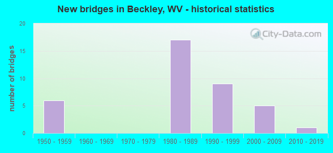
- New bridges - historical statistics
- 61950-1959
- 171980-1989
- 91990-1999
- 52000-2009
- 12010-2019
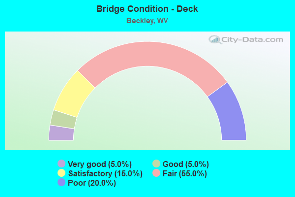
- Bridge Condition - Deck
- 5.0%Very good
- 5.0%Good
- 15.0%Satisfactory
- 55.0%Fair
- 20.0%Poor
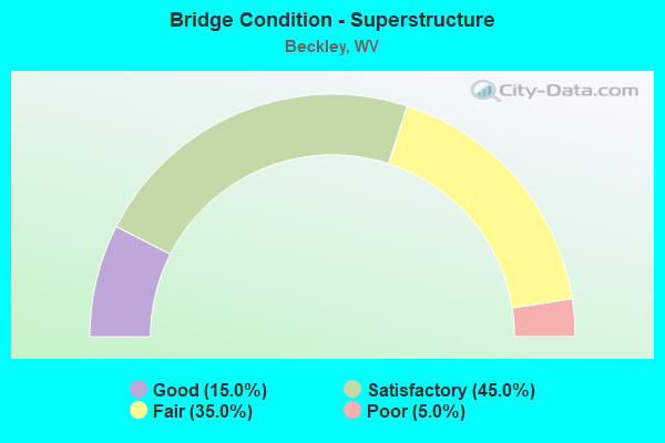
- Bridge Condition - Superstructure
- 15.0%Good
- 45.0%Satisfactory
- 35.0%Fair
- 5.0%Poor
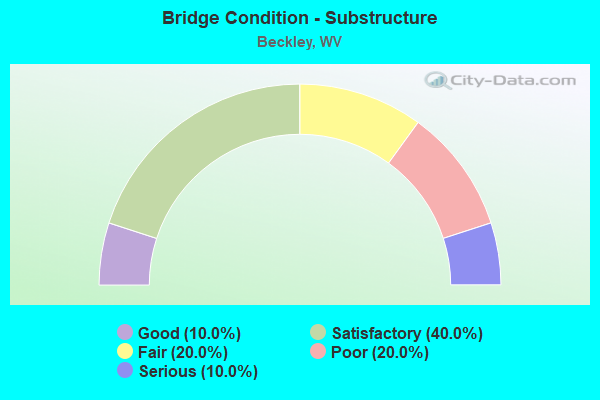
- Bridge Condition - Substructure
- 10.0%Good
- 40.0%Satisfactory
- 20.0%Fair
- 20.0%Poor
- 10.0%Serious
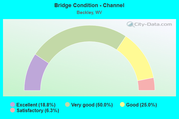
- Bridge Condition - Channel
- 18.8%Excellent
- 50.0%Very good
- 25.0%Good
- 6.3%Satisfactory
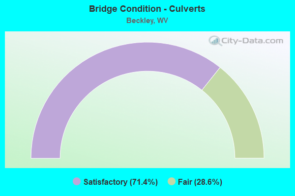
- Bridge Condition - Culverts
- 71.4%Satisfactory
- 28.6%Fair
Find on map >> Show street view
Structure Number: 41A027, Location: 0.13 MI E OF CR 3/49 (Lat: 37.793281, Lng: -81.216850), Route carried "on" structure: State highway 300, Year Built: 1983, Status: Open, Structure Length: 6.10m (20.01ft), Average Daily Traffic: 8,700 (year 2019), Truck Traffic: 5%, Average Future Daily Traffic: 10,962 (year 2039), Design Load: HS 20, Features Intersected: I-77/64 TPK, Facility Carried by Structure: WV RT 3
Minimum Vertical Clearance: 30+ m (98+ ft), Kilometerpoint: 57.872, Lanes on structure: 6, Lanes under structure: 4, Toll: On toll road, Owner: State Highway Agency, Approaching Roadway Width: 9.1m (29.9ft), Skew: 1 degrees, Material/Design: Steel continuous, Design/Construction: Stringer/Multi-beam, Number Of Spans In Main Unit: 2, Length of Maximum Span: 29.9m (98.1ft), Curb-To-Curb Width: 27.1m (88.9ft), Out-to-Out Width: 28.2m (92.5ft)
Condition: Deck: Fair, Superstructure: Fair, Substructure: Serious, Operating Rating: 59.9 metric tons, Method Used To Determine Operating Rating: Load Factor (LF), Inventory Rating: 35.4 metric tons, Method Used To Determine Inventory Rating: Load Factor (LF), Structural Evaluation: High priority of corrective action, Deck Geometry: Better than present minimum criteria, Underclear: Somewhat better than minimum adequacy, Approach Roadway Alignment: Better than present minimum criteria, Length Of Structure Improvement: 5.97m (19.59ft), Designated Inspection Frequency: Every 24 months, Inspection Date: April 2021, Bridge Improvement Cost: $1,500,000, Total Project Cost: $1,500,000 ( Estimate for 2019), Deck Structure Type: Concrete Cast-file-Place, Wearing Surface/Protective System: Wearing Surface: Integral Concrete, Deck Protection: Epoxy Coated Reinforcing
Find on map >> Show street view
Structure Number: 41A073, Location: 0.38 MI. N. OF CR 16/6 (Lat: 37.765531, Lng: -81.201339), Route carried "on" structure: State highway 1600, Year Built: 1958, Status: Posted for load, Structure Length: 3.96m (12.99ft), Average Daily Traffic: 16,200 (year 2019), Truck Traffic: 7%, Average Future Daily Traffic: 17,010 (year 2039), Design Load: H 20, Features Intersected: Cova Street, Facility Carried by Structure: WV. 16
Minimum Vertical Clearance: 30+ m (98+ ft), Kilometerpoint: 26.538, Lanes on structure: 5, Lanes under structure: 2, Owner: State Highway Agency, Approaching Roadway Width: 21.3m (69.9ft), Skew: 22 degrees, Material/Design: Steel continuous, Design/Construction: Stringer/Multi-beam, Number Of Spans In Main Unit: 1, Number Of Approach Spans: 2, Length of Maximum Span: 14.6m (47.9ft), Curb-To-Curb Width: 20.1m (65.9ft), Out-to-Out Width: 22.3m (73.2ft)
Condition: Deck: Poor, Superstructure: Fair, Substructure: Poor, Operating Rating: 26.3 metric tons, Method Used To Determine Operating Rating: Load Factor (LF), Inventory Rating: 15.4 metric tons, Method Used To Determine Inventory Rating: Load Factor (LF), Structural Evaluation: High priority of replacement, Deck Geometry: Somewhat better than minimum adequacy, Underclear: Meets minimum limits, Approach Roadway Alignment: Equal to present desirable criteria, Bridge Posting: Required (Relationship of Operating Rating to Maximum Legal Load: 10.0 - 19.9% below), Length Of Structure Improvement: 3.96m (12.99ft), Designated Inspection Frequency: Every 24 months, Inspection Date: September 2021, Bridge Improvement Cost: $3,500,000, Roadway Improvement Cost: $500,000, Total Project Cost: $4,000,000 ( Estimate for 2021), Deck Structure Type: Concrete Cast-file-Place, Wearing Surface/Protective System: Wearing Surface: Bituminous
Find on map >> Show street view
Structure Number: 41A074, Location: 0.09 MI. N. OF WV. 3 (Lat: 37.773850, Lng: -81.194789), Route carried "on" structure: State highway 1600, Year Built: 1959, Status: Open, Structure Length: 2.29m (7.51ft), Average Daily Traffic: 16,000 (year 2018), Truck Traffic: 5%, Average Future Daily Traffic: 20,160 (year 2038), Design Load: H 20, Features Intersected: BECKLEY BIKE & PED TRAIL, Facility Carried by Structure: WV. RTE. 16
Minimum Vertical Clearance: 30+ m (98+ ft), Kilometerpoint: 27.809, Lanes on structure: 5, Owner: State Highway Agency, Approaching Roadway Width: 9.1m (29.9ft), Skew: 6 degrees, Material/Design: Prestressed concrete, Design/Construction: Slab, Number Of Spans In Main Unit: 1, Length of Maximum Span: 22.2m (72.8ft), Curb or Sidewalk Widths: Left: 1.5m (4.9ft), Right: 1.5m (4.9ft), Curb-To-Curb Width: 18.3m (60.0ft), Out-to-Out Width: 21.3m (69.9ft)
Condition: Deck: Poor, Superstructure: Poor, Substructure: Poor, Operating Rating: 46.3 metric tons, Method Used To Determine Operating Rating: Field evaluation and documented engineering judgment, Inventory Rating: 18.1 metric tons, Method Used To Determine Inventory Rating: Field evaluation and documented engineering judgment, Structural Evaluation: Meets minimum limits, Deck Geometry: High priority of replacement, Approach Roadway Alignment: Better than present minimum criteria, Length Of Structure Improvement: 0.98m (3.22ft), Designated Inspection Frequency: Every 24 months, Inspection Date: June 2020, Bridge Improvement Cost: $750,000, Roadway Improvement Cost: $500,000, Total Project Cost: $1,250,000 ( Estimate for 2020), Deck Structure Type: Other, Wearing Surface/Protective System: Wearing Surface: Bituminous
Find on map >> Show street view
Structure Number: 41A082, Location: 0.01 MI N OF CR 19/42 (Lat: 37.757111, Lng: -81.156739), Route carried "on" structure: US 1900, Year Built: 1954, Status: Posted for load, Structure Length: 3.19m (10.47ft), Average Daily Traffic: 15,100 (year 2018), Truck Traffic: 7%, Average Future Daily Traffic: 19,026 (year 2038), Design Load: HS 15, Features Intersected: PINEY CREEK, Facility Carried by Structure: US 19 & WV 3
Minimum Vertical Clearance: 30+ m (98+ ft), Kilometerpoint: 23.094, Lanes on structure: 2, Base Highway Network: Yes, Owner: State Highway Agency, Approaching Roadway Width: 11.6m (38.1ft), Material/Design: Steel continuous, Design/Construction: Stringer/Multi-beam, Number Of Spans In Main Unit: 2, Length of Maximum Span: 15.3m (50.2ft), Curb or Sidewalk Widths: Left: 0.9m (3.0ft), Right: 0.9m (3.0ft), Curb-To-Curb Width: 8.6m (28.2ft), Out-to-Out Width: 11.0m (36.1ft)
Condition: Deck: Poor, Superstructure: Fair, Substructure: Poor, Channel: Satisfactory, Operating Rating: 41.7 metric tons, Method Used To Determine Operating Rating: Load Factor (LF), Inventory Rating: 24.5 metric tons, Method Used To Determine Inventory Rating: Load Factor (LF), Structural Evaluation: Meets minimum limits, Deck Geometry: High priority of replacement, Waterway Adequacy: Equal to present desirable criteria, Approach Roadway Alignment: Equal to present minimum criteria, Length Of Structure Improvement: 3.20m (10.50ft), Designated Inspection Frequency: Every 24 months, Inspection Date: August 2020, Bridge Improvement Cost: $3,500,000, Roadway Improvement Cost: $100,000, Total Project Cost: $3,600,000 ( Estimate for 2020), Deck Structure Type: Concrete Cast-file-Place, Wearing Surface/Protective System: Wearing Surface: Bituminous
Find on map >> Show street view
Structure Number: 41A086, Location: 0.07 MI. E. OF CR. 21/3 (Lat: 37.793619, Lng: -81.174681), Route carried "on" structure: County highway 1908, Year Built: 1955, Status: Posted for load, Structure Length: 4.00m (13.12ft), Average Daily Traffic: 9,000 (year 2019), Truck Traffic: 6%, Average Future Daily Traffic: 16,560 (year 2039), Design Load: HS 15, Features Intersected: Rails to Trails, Facility Carried by Structure: COUNTY ROUTE 19/8
Minimum Vertical Clearance: 30+ m (98+ ft), Kilometerpoint: 0.982, Lanes on structure: 2, Owner: State Highway Agency, Approaching Roadway Width: 7.9m (25.9ft), Skew: 3 degrees, Material/Design: Steel, Design/Construction: Stringer/Multi-beam, Number Of Spans In Main Unit: 1, Number Of Approach Spans: 2, Length of Maximum Span: 17.8m (58.4ft), Curb or Sidewalk Widths: Left: 1.0m (3.3ft), Right: 1.0m (3.3ft), Curb-To-Curb Width: 7.9m (25.9ft), Out-to-Out Width: 10.4m (34.1ft)
Condition: Deck: Poor, Superstructure: Fair, Substructure: Serious, Operating Rating: 37.2 metric tons, Method Used To Determine Operating Rating: Load Factor (LF), Inventory Rating: 22.7 metric tons, Method Used To Determine Inventory Rating: Load Factor (LF), Structural Evaluation: High priority of corrective action, Deck Geometry: High priority of replacement, Approach Roadway Alignment: Equal to present minimum criteria, Length Of Structure Improvement: 3.99m (13.09ft), Designated Inspection Frequency: Every 24 months, Other Special Inspection Frequency: Every 12 months, Inspection Date: June 2021, Other Special Inspection Date: June 2021, Bridge Improvement Cost: $2,500,000, Roadway Improvement Cost: $500,000, Total Project Cost: $3,000,000 ( Estimate for 2019), Deck Structure Type: Concrete Cast-file-Place, Wearing Surface/Protective System: Wearing Surface: Bituminous
Find on map >> Show street view
Structure Number: 41A162, Location: 0.24 MI E OF US 19 (Lat: 37.767750, Lng: -81.156600), Route carried "on" structure: US 1900, Year Built: 1988, Status: Posted for load, Structure Length: 53.94m (176.97ft), Average Daily Traffic: 4,700 (year 2019), Truck Traffic: 7%, Average Future Daily Traffic: 5,922 (year 2039), Design Load: HS 20, Features Intersected: PINEY CREEK, Facility Carried by Structure: US 19 CONNECTOR
Minimum Vertical Clearance: 30+ m (98+ ft), Kilometerpoint: 0.386, Lanes on structure: 4, Base Highway Network: Yes, Owner: State Highway Agency, Approaching Roadway Width: 12.2m (40.0ft), Skew: 30 degrees, Material/Design: Steel continuous, Design/Construction: Girder and Floorbeam System, Number Of Spans In Main Unit: 3, Number Of Approach Spans: 5, Length of Maximum Span: 79.2m (259.8ft), Curb-To-Curb Width: 21.2m (69.6ft), Out-to-Out Width: 22.9m (75.1ft)
Condition: Deck: Fair, Superstructure: Fair, Substructure: Poor, Channel: Very good, Operating Rating: 50.8 metric tons, Method Used To Determine Operating Rating: Load Factor (LF), Inventory Rating: 29.9 metric tons, Method Used To Determine Inventory Rating: Load Factor (LF), Structural Evaluation: Meets minimum limits, Deck Geometry: Superior to present desirable criteria, Underclear: Superior to present desirable criteria, Waterway Adequacy: Superior to present desirable criteria, Approach Roadway Alignment: Equal to present desirable criteria, Designated Inspection Frequency: Every 24 months, Critical Feature Inspection Frequency: Every 24 months, Inspection Date: April 2021, Critical Feature Inspection Date: April 2021, Deck Structure Type: Concrete Cast-file-Place, Wearing Surface/Protective System: Wearing Surface: Monolithic Concrete, Deck Protection: Epoxy Coated Reinforcing
Find on map >> Show street view
Structure Number: 41A172, Location: 0.03 MI.W.OF US 19 (Lat: 37.761831, Lng: -81.146650), Route carried "on" structure: Interstate 6400, Year Built: 1985, Status: Open, Structure Length: 4.75m (15.58ft), Average Daily Traffic: 8,650 (year 2018), Truck Traffic: 27%, Average Future Daily Traffic: 10,899 (year 2038), Design Load: HS 20+Mod, Features Intersected: US 19 Connector, Facility Carried by Structure: I-64
Minimum Vertical Clearance: 30+ m (98+ ft), Kilometerpoint: 198.915, Lanes on structure: 4, Lanes under structure: 3, Base Highway Network: Yes, Owner: State Highway Agency, Approaching Roadway Width: 13.4m (44.0ft), Skew: 10 degrees, Material/Design: Steel continuous, Design/Construction: Stringer/Multi-beam, Number Of Spans In Main Unit: 1, Number Of Approach Spans: 1, Length of Maximum Span: 24.1m (79.1ft), Curb-To-Curb Width: 21.6m (70.9ft), Out-to-Out Width: 22.6m (74.1ft)
Condition: Deck: Satisfactory, Superstructure: Good, Substructure: Fair, Operating Rating: 58.0 metric tons, Method Used To Determine Operating Rating: Load Factor (LF), Inventory Rating: 34.5 metric tons, Method Used To Determine Inventory Rating: Load Factor (LF), Structural Evaluation: Somewhat better than minimum adequacy, Deck Geometry: Better than present minimum criteria, Underclear: Meets minimum limits, Approach Roadway Alignment: Equal to present desirable criteria, Designated Inspection Frequency: Every 24 months, Inspection Date: October 2020, Deck Structure Type: Concrete Cast-file-Place, Wearing Surface/Protective System: Wearing Surface: Monolithic Concrete, Deck Protection: Epoxy Coated Reinforcing
Find on map >> Show street view
Structure Number: 41A188, Location: 0.03 MI.W.OF US 19 (Lat: 37.761969, Lng: -81.146919), Route carried "on" structure: Interstate 6400, Year Built: 1985, Status: Open, Structure Length: 4.75m (15.58ft), Average Daily Traffic: 8,650 (year 2018), Truck Traffic: 27%, Average Future Daily Traffic: 10,899 (year 2038), Design Load: HS 20, Features Intersected: US 19 Connector, Facility Carried by Structure: I-64 WB
Minimum Vertical Clearance: 30+ m (98+ ft), Kilometerpoint: 198.915, Lanes on structure: 2, Lanes under structure: 3, Base Highway Network: Yes, Owner: State Highway Agency, Approaching Roadway Width: 13.4m (44.0ft), Skew: 10 degrees, Material/Design: Steel continuous, Design/Construction: Stringer/Multi-beam, Number Of Spans In Main Unit: 1, Number Of Approach Spans: 1, Length of Maximum Span: 24.1m (79.1ft), Curb-To-Curb Width: 12.4m (40.7ft), Out-to-Out Width: 13.5m (44.3ft)
Condition: Deck: Satisfactory, Superstructure: Satisfactory, Substructure: Fair, Operating Rating: 57.1 metric tons, Method Used To Determine Operating Rating: Load Factor (LF), Inventory Rating: 34.5 metric tons, Method Used To Determine Inventory Rating: Load Factor (LF), Structural Evaluation: Somewhat better than minimum adequacy, Deck Geometry: Better than present minimum criteria, Underclear: Meets minimum limits, Approach Roadway Alignment: Equal to present desirable criteria, Designated Inspection Frequency: Every 24 months, Inspection Date: September 2020, Deck Structure Type: Concrete Cast-file-Place, Wearing Surface/Protective System: Wearing Surface: Monolithic Concrete, Deck Protection: Epoxy Coated Reinforcing
Find on map >> Show street view
Structure Number: 41A198, Location: 0.01 Mi. S. Of CR. 16/19 (Lat: 37.789200, Lng: -81.185300), Route carried "on" structure: State highway 1600, Year Built: 1988, Status: Open, Structure Length: 1.27m (4.17ft), Average Daily Traffic: 23,900 (year 2018), Truck Traffic: 5%, Average Future Daily Traffic: 30,114 (year 2038), Design Load: HS 20, Features Intersected: LITTLE WHITESTICK CREEK, Facility Carried by Structure: WV RT 16
Minimum Vertical Clearance: 30+ m (98+ ft), Kilometerpoint: 29.918, Lanes on structure: 5, Owner: State Highway Agency, Approaching Roadway Width: 21.9m (71.9ft), Skew: 1 degrees, Material/Design: Prestressed concrete, Design/Construction: Box Beam or Girders - Multiple, Number Of Spans In Main Unit: 1, Length of Maximum Span: 11.6m (38.1ft), Curb or Sidewalk Widths: Left: 1.6m (5.2ft), Right: 1.5m (4.9ft), Curb-To-Curb Width: 20.3m (66.6ft), Out-to-Out Width: 24.0m (78.7ft)
Condition: Deck: Fair, Superstructure: Fair, Substructure: Satisfactory, Channel: Very good, Operating Rating: 83.4 metric tons, Method Used To Determine Operating Rating: Load Factor (LF), Inventory Rating: 49.9 metric tons, Method Used To Determine Inventory Rating: Load Factor (LF), Structural Evaluation: Somewhat better than minimum adequacy, Deck Geometry: Somewhat better than minimum adequacy, Waterway Adequacy: Equal to present desirable criteria, Approach Roadway Alignment: Better than present minimum criteria, Length Of Structure Improvement: 1.27m (4.17ft), Designated Inspection Frequency: Every 24 months, Inspection Date: December 2020, Bridge Improvement Cost: $1,500,000, Roadway Improvement Cost: $250,000, Total Project Cost: $1,750,000 ( Estimate for 2021), Deck Structure Type: Other, Wearing Surface/Protective System: Wearing Surface: Bituminous, Deck Protection: Epoxy Coated Reinforcing
Find on map >> Show street view
Structure Number: 41A219, Location: 0.99 MI. N. OF WV. 3 (Lat: 37.780400, Lng: -81.220861), Route carried "on" structure: Interstate 7700, Year Built: 1984, Status: Open, Structure Length: 15.76m (51.71ft), Average Daily Traffic: 21,801 (year 2018), Truck Traffic: 17%, Average Future Daily Traffic: 43,820 (year 2038), Design Load: HS 20+Mod, Features Intersected: Cabell Rd, CSX RR, Facility Carried by Structure: I-77 N
Minimum Vertical Clearance: 30+ m (98+ ft), Kilometerpoint: 70.151, Lanes on structure: 2, Lanes under structure: 2, Base Highway Network: Yes, Toll: On Interstate toll segment, Owner: State Toll Authority, Approaching Roadway Width: 11.3m (37.1ft), Skew: 2 degrees, Material/Design: Steel continuous, Design/Construction: Stringer/Multi-beam, Number Of Spans In Main Unit: 1, Number Of Approach Spans: 4, Length of Maximum Span: 35.8m (117.5ft), Curb-To-Curb Width: 12.4m (40.7ft), Out-to-Out Width: 13.5m (44.3ft)
Condition: Deck: Fair, Superstructure: Satisfactory, Substructure: Fair, Operating Rating: 68.0 metric tons, Method Used To Determine Operating Rating: Load Factor (LF), Inventory Rating: 40.8 metric tons, Method Used To Determine Inventory Rating: Load Factor (LF), Structural Evaluation: Somewhat better than minimum adequacy, Deck Geometry: Better than present minimum criteria, Underclear: Superior to present desirable criteria, Waterway Adequacy: Superior to present desirable criteria, Approach Roadway Alignment: Equal to present desirable criteria, Designated Inspection Frequency: Every 24 months, Other Special Inspection Frequency: Every 12 months, Inspection Date: June 2020, Other Special Inspection Date: September 2021, Deck Structure Type: Concrete Cast-file-Place, Wearing Surface/Protective System: Wearing Surface: Monolithic Concrete, Deck Protection: Epoxy Coated Reinforcing
Find on map >> Show street view
Structure Number: 41A22, Location: WV ROUTE 16 (Lat: 37.758569, Lng: -81.212669), Route carried "on" structure: Interstate 7700, Year Built: 1984, Status: Open, Structure Length: 10.54m (34.58ft), Average Daily Traffic: 13,195 (year 2019), Truck Traffic: 17%, Average Future Daily Traffic: 27,709 (year 2039), Design Load: HS 20+Mod, Features Intersected: PEMBERTON ROAD AND RT 16, Facility Carried by Structure: I-77 NB.
Minimum Vertical Clearance: 30+ m (98+ ft), Kilometerpoint: 67.592, Lanes on structure: 3, Lanes under structure: 2, Base Highway Network: Yes, Toll: On Interstate toll segment, Owner: State Toll Authority, Approaching Roadway Width: 15.5m (50.9ft), Skew: 2 degrees, Material/Design: Steel continuous, Design/Construction: Stringer/Multi-beam, Number Of Spans In Main Unit: 1, Number Of Approach Spans: 4, Length of Maximum Span: 27.3m (89.6ft), Curb-To-Curb Width: 16.4m (53.8ft), Out-to-Out Width: 17.5m (57.4ft)
Condition: Deck: Fair, Superstructure: Satisfactory, Substructure: Satisfactory, Operating Rating: 57.1 metric tons, Method Used To Determine Operating Rating: Load Factor (LF), Inventory Rating: 34.5 metric tons, Method Used To Determine Inventory Rating: Load Factor (LF), Structural Evaluation: Equal to present minimum criteria, Deck Geometry: Equal to present minimum criteria, Underclear: Meets minimum limits, Approach Roadway Alignment: Equal to present desirable criteria, Designated Inspection Frequency: Every 24 months, Inspection Date: June 2020, Deck Structure Type: Concrete Cast-file-Place, Wearing Surface/Protective System: Wearing Surface: Monolithic Concrete, Deck Protection: Epoxy Coated Reinforcing
Find on map >> Show street view
Structure Number: 41A226, Location: 0.30 MI. N. WV. 16 (Lat: 37.762411, Lng: -81.214469), Route carried "on" structure: Interstate 7700, Year Built: 1984, Status: Open, Structure Length: 10.54m (34.58ft), Average Daily Traffic: 18,517 (year 2013), Truck Traffic: 17%, Average Future Daily Traffic: 38,886 (year 2033), Design Load: HS 20+Mod, Features Intersected: ROUTE 16 CONNECTOR, Facility Carried by Structure: I-77 N
Minimum Vertical Clearance: 30+ m (98+ ft), Kilometerpoint: 68.075, Lanes on structure: 2, Lanes under structure: 3, Base Highway Network: Yes, Toll: On Interstate toll segment, Owner: State Toll Authority, Approaching Roadway Width: 11.3m (37.1ft), Skew: 2 degrees, Material/Design: Steel continuous, Design/Construction: Stringer/Multi-beam, Number Of Spans In Main Unit: 1, Number Of Approach Spans: 1, Length of Maximum Span: 29.3m (96.1ft), Curb-To-Curb Width: 16.4m (53.8ft), Out-to-Out Width: 17.5m (57.4ft)
Condition: Deck: Fair, Superstructure: Satisfactory, Substructure: Satisfactory, Operating Rating: 56.2 metric tons, Method Used To Determine Operating Rating: Load Factor (LF), Inventory Rating: 33.6 metric tons, Method Used To Determine Inventory Rating: Load Factor (LF), Structural Evaluation: Equal to present minimum criteria, Deck Geometry: Superior to present desirable criteria, Underclear: Somewhat better than minimum adequacy, Approach Roadway Alignment: Equal to present desirable criteria, Designated Inspection Frequency: Every 24 months, Inspection Date: June 2020, Deck Structure Type: Concrete Cast-file-Place, Wearing Surface/Protective System: Wearing Surface: Monolithic Concrete, Deck Protection: Epoxy Coated Reinforcing
Find on map >> Show street view
Structure Number: 41A228, Location: 1.11 MI N OF I-64 (Lat: 37.743311, Lng: -81.208231), Route carried "on" structure: Interstate 7700, Year Built: 1985, Status: Open, Structure Length: 11.39m (37.37ft), Average Daily Traffic: 44,828 (year 2015), Truck Traffic: 30%, Average Future Daily Traffic: 49,352 (year 2035), Design Load: HS 20+Mod, Features Intersected: PINEY CREEK & CSX RR, Facility Carried by Structure: I-77 SB
Minimum Vertical Clearance: 30+ m (98+ ft), Kilometerpoint: 65.710, Lanes on structure: 3, Base Highway Network: Yes, Toll: On Interstate toll segment, Owner: State Toll Authority, Approaching Roadway Width: 19.2m (63.0ft), Skew: 11 degrees, Material/Design: Steel continuous, Design/Construction: Stringer/Multi-beam, Number Of Spans In Main Unit: 1, Number Of Approach Spans: 2, Length of Maximum Span: 45.9m (150.6ft), Curb-To-Curb Width: 19.0m (62.3ft), Out-to-Out Width: 20.0m (65.6ft)
Condition: Deck: Fair, Superstructure: Satisfactory, Substructure: Satisfactory, Channel: Very good, Operating Rating: 65.3 metric tons, Method Used To Determine Operating Rating: Load Factor (LF), Inventory Rating: 39.0 metric tons, Method Used To Determine Inventory Rating: Load Factor (LF), Structural Evaluation: Equal to present minimum criteria, Deck Geometry: Superior to present desirable criteria, Underclear: Equal to present desirable criteria, Waterway Adequacy: Superior to present desirable criteria, Approach Roadway Alignment: Equal to present desirable criteria, Designated Inspection Frequency: Every 24 months, Inspection Date: October 2020, Deck Structure Type: Concrete Cast-file-Place, Wearing Surface/Protective System: Wearing Surface: Monolithic Concrete, Deck Protection: Epoxy Coated Reinforcing
Find on map >> Show street view
Structure Number: 41A229, Location: 0.99 MI S OF RT 3 I/C (Lat: 37.780469, Lng: -81.221211), Route carried "on" structure: Interstate 7700, Year Built: 1985, Status: Open, Structure Length: 16.70m (54.79ft), Average Daily Traffic: 21,801 (year 2018), Truck Traffic: 17%, Average Future Daily Traffic: 43,602 (year 2038), Design Load: HS 20+Mod, Features Intersected: WHITESTICK CRK/CABELL RD, Facility Carried by Structure: I-77 SB
Minimum Vertical Clearance: 30+ m (98+ ft), Kilometerpoint: 70.151, Lanes on structure: 2, Lanes under structure: 2, Base Highway Network: Yes, Toll: On Interstate toll segment, Owner: State Toll Authority, Approaching Roadway Width: 11.3m (37.1ft), Skew: 2 degrees, Material/Design: Steel continuous, Design/Construction: Stringer/Multi-beam, Number Of Spans In Main Unit: 1, Number Of Approach Spans: 4, Length of Maximum Span: 37.8m (124.0ft), Curb-To-Curb Width: 12.4m (40.7ft), Out-to-Out Width: 13.5m (44.3ft)
Condition: Deck: Very good, Superstructure: Satisfactory, Substructure: Satisfactory, Channel: Very good, Operating Rating: 63.5 metric tons, Method Used To Determine Operating Rating: Load Factor (LF), Inventory Rating: 38.1 metric tons, Method Used To Determine Inventory Rating: Load Factor (LF), Structural Evaluation: Equal to present minimum criteria, Deck Geometry: Better than present minimum criteria, Underclear: Equal to present minimum criteria, Waterway Adequacy: Equal to present desirable criteria, Approach Roadway Alignment: Equal to present desirable criteria, Designated Inspection Frequency: Every 24 months, Other Special Inspection Frequency: Every 12 months, Inspection Date: September 2021, Other Special Inspection Date: September 2021, Deck Structure Type: Concrete Cast-file-Place, Wearing Surface/Protective System: Wearing Surface: Epoxy Overlay, Membrane: Epoxy, Deck Protection: Epoxy Coated Reinforcing
Find on map >> Show street view
Structure Number: 41A237, Location: 1.38 MI N OF WV RT 3 (Lat: 37.810311, Lng: -81.212469), Route carried "on" structure: Ramp Interstate 7700, Year Built: 1996, Status: Open, Structure Length: 7.73m (25.36ft), Average Daily Traffic: 2,644 (year 2018), Truck Traffic: 17%, Average Future Daily Traffic: 5,552 (year 2038), Design Load: HS 25 or greater, Features Intersected: I77 EXIT 45 ACCESS RD 8, Facility Carried by Structure: ACCESS RD 8
Minimum Vertical Clearance: 30+ m (98+ ft), Kilometerpoint: 73.724, Lanes on structure: 2, Lanes under structure: 6, Toll: On Interstate toll segment, Owner: State Toll Authority, Approaching Roadway Width: 19.5m (64.0ft), Material/Design: Steel continuous, Design/Construction: Stringer/Multi-beam, Number Of Spans In Main Unit: 2, Length of Maximum Span: 39.8m (130.6ft), Curb-To-Curb Width: 20.7m (67.9ft), Out-to-Out Width: 21.8m (71.5ft)
Condition: Deck: Satisfactory, Superstructure: Satisfactory, Substructure: Satisfactory, Operating Rating: 68.0 metric tons, Method Used To Determine Operating Rating: Load Factor (LF), Inventory Rating: 40.8 metric tons, Method Used To Determine Inventory Rating: Load Factor (LF), Structural Evaluation: Equal to present minimum criteria, Deck Geometry: Superior to present desirable criteria, Underclear: Equal to present minimum criteria, Approach Roadway Alignment: Equal to present desirable criteria, Designated Inspection Frequency: Every 24 months, Inspection Date: May 2021, Deck Structure Type: Concrete Cast-file-Place, Wearing Surface/Protective System: Wearing Surface: Monolithic Concrete, Deck Protection: Epoxy Coated Reinforcing
Find on map >> Show street view
Structure Number: 41A238, Location: 1.02 MI N OF WV RT 3 (Lat: 37.804881, Lng: -81.213339), Route carried "on" structure: Ramp Interstate 7700, Year Built: 1996, Status: Open, Structure Length: 2.81m (9.22ft), Average Daily Traffic: 2,500 (year 2012), Truck Traffic: 17%, Average Future Daily Traffic: 5,250 (year 2031), Design Load: HS 25 or greater, Features Intersected: ACC RD 2,I77,BECKLEY I/C, Facility Carried by Structure: ACCESS RD 2
Minimum Vertical Clearance: 30+ m (98+ ft), Kilometerpoint: 73.563, Lanes on structure: 1, Lanes under structure: 1, Toll: On Interstate toll segment, Owner: State Toll Authority, Approaching Roadway Width: 6.7m (22.0ft), Skew: 4 degrees, Material/Design: Steel continuous, Design/Construction: Stringer/Multi-beam, Number Of Spans In Main Unit: 1, Length of Maximum Span: 26.2m (86.0ft), Curb-To-Curb Width: 8.5m (27.9ft), Out-to-Out Width: 9.6m (31.5ft)
Condition: Deck: Good, Superstructure: Satisfactory, Substructure: Satisfactory, Operating Rating: 89.8 metric tons, Method Used To Determine Operating Rating: Load Factor (LF), Inventory Rating: 54.4 metric tons, Method Used To Determine Inventory Rating: Load Factor (LF), Structural Evaluation: Equal to present minimum criteria, Deck Geometry: Superior to present desirable criteria, Underclear: Equal to present desirable criteria, Approach Roadway Alignment: Equal to present desirable criteria, Designated Inspection Frequency: Every 24 months, Inspection Date: May 2021, Deck Structure Type: Concrete Cast-file-Place, Wearing Surface/Protective System: Wearing Surface: Monolithic Concrete, Deck Protection: Epoxy Coated Reinforcing
Find on map >> Show street view
Structure Number: 41A265, Location: 0.10 MI. EAST OF US 19 (Lat: 37.806289, Lng: -81.182811), Route carried "on" structure: County highway 800, Year Built: 1996, Status: Open, Structure Length: 2.17m (7.12ft), Average Daily Traffic: 5,800 (year 2018), Truck Traffic: 5%, Average Future Daily Traffic: 7,308 (year 2038), Design Load: HS 25 or greater, Features Intersected: CRANBERRY CREEK, Facility Carried by Structure: CO 8
Minimum Vertical Clearance: 30+ m (98+ ft), Kilometerpoint: 0.161, Lanes on structure: 2, Owner: State Highway Agency, Approaching Roadway Width: 7.3m (24.0ft), Skew: 1 degrees, Material/Design: Prestressed concrete, Design/Construction: Stringer/Multi-beam, Number Of Spans In Main Unit: 1, Length of Maximum Span: 20.7m (67.9ft), Curb-To-Curb Width: 9.2m (30.2ft), Out-to-Out Width: 10.2m (33.5ft)
Condition: Deck: Fair, Superstructure: Satisfactory, Substructure: Good, Channel: Good, Operating Rating: 78.0 metric tons, Method Used To Determine Operating Rating: Load Factor (LF), Inventory Rating: 47.2 metric tons, Method Used To Determine Inventory Rating: Load Factor (LF), Structural Evaluation: Equal to present minimum criteria, Deck Geometry: High priority of corrective action, Waterway Adequacy: Superior to present desirable criteria, Approach Roadway Alignment: Equal to present desirable criteria, Length Of Structure Improvement: 2.16m (7.09ft), Designated Inspection Frequency: Every 24 months, Inspection Date: December 2020, Bridge Improvement Cost: $750,000, Roadway Improvement Cost: $250,000, Total Project Cost: $1,000,000 ( Estimate for 2021), Deck Structure Type: Concrete Cast-file-Place, Wearing Surface/Protective System: Wearing Surface: Monolithic Concrete, Deck Protection: Epoxy Coated Reinforcing
Find on map >> Show street view
Structure Number: 41A266, Location: 0.11 MI NORTH OF US 19 (Lat: 37.794981, Lng: -81.172539), Route carried "on" structure: State highway 4100, Year Built: 1996, Status: Open, Structure Length: 2.57m (8.43ft), Average Daily Traffic: 8,200 (year 2018), Truck Traffic: 5%, Average Future Daily Traffic: 10,332 (year 2038), Design Load: HS 25 or greater, Features Intersected: CRANBERRY CREEK, Facility Carried by Structure: WV 41
Minimum Vertical Clearance: 30+ m (98+ ft), Kilometerpoint: 2.897, Lanes on structure: 2, Base Highway Network: Yes, Owner: State Highway Agency, Approaching Roadway Width: 9.1m (29.9ft), Skew: 1 degrees, Material/Design: Prestressed concrete, Design/Construction: Stringer/Multi-beam, Number Of Spans In Main Unit: 1, Length of Maximum Span: 24.4m (80.1ft), Curb-To-Curb Width: 9.1m (29.9ft), Out-to-Out Width: 10.2m (33.5ft)
Condition: Deck: Fair, Superstructure: Good, Substructure: Good, Channel: Excellent, Operating Rating: 68.9 metric tons, Method Used To Determine Operating Rating: Load Factor (LF), Inventory Rating: 40.8 metric tons, Method Used To Determine Inventory Rating: Load Factor (LF), Structural Evaluation: Better than present minimum criteria, Deck Geometry: High priority of corrective action, Waterway Adequacy: Superior to present desirable criteria, Approach Roadway Alignment: Better than present minimum criteria, Length Of Structure Improvement: 2.56m (8.40ft), Designated Inspection Frequency: Every 24 months, Inspection Date: December 2020, Bridge Improvement Cost: $1,250,000, Roadway Improvement Cost: $250,000, Total Project Cost: $1,500,000 ( Estimate for 2021), Deck Structure Type: Concrete Cast-file-Place, Wearing Surface/Protective System: Wearing Surface: Monolithic Concrete, Deck Protection: Epoxy Coated Reinforcing
Find on map >> Show street view
Structure Number: 41A303, Location: 0.04 MI WEST OF CO 19/67 (Lat: 37.788350, Lng: -81.183211), Route carried "on" structure: County highway 1602, Year Built: 2004, Status: Open, Structure Length: 1.77m (5.81ft), Average Daily Traffic: 500 (year 2019), Truck Traffic: 6%, Average Future Daily Traffic: 920 (year 2039), Design Load: HS 20, Features Intersected: LITTLE WHITESTICK CREEK, Facility Carried by Structure: CO 16/2
Minimum Vertical Clearance: 30+ m (98+ ft), Kilometerpoint: 0.322, Lanes on structure: 2, Owner: State Highway Agency, Approaching Roadway Width: 5.5m (18.0ft), Skew: 5 degrees, Material/Design: Concrete continuous, Design/Construction: Culvert, Number Of Spans In Main Unit: 3, Length of Maximum Span: 5.1m (16.7ft), Curb-To-Curb Width: 7.3m (24.0ft), Out-to-Out Width: 7.8m (25.6ft)
Condition: Channel: Excellent, Culverts: Satisfactory, Operating Rating: 71.7 metric tons, Method Used To Determine Operating Rating: Field evaluation and documented engineering judgment, Inventory Rating: 32.7 metric tons, Method Used To Determine Inventory Rating: Field evaluation and documented engineering judgment, Structural Evaluation: Equal to present minimum criteria, Deck Geometry: Meets minimum limits, Waterway Adequacy: Equal to present desirable criteria, Approach Roadway Alignment: Better than present minimum criteria, Designated Inspection Frequency: Every 24 months, Inspection Date: August 2021, Deck Structure Type: Concrete Cast-file-Place, Wearing Surface/Protective System: Deck Protection: Epoxy Coated Reinforcing
Find on map >> Show street view
Structure Number: 41A304, Location: 0.03 MI NORTH OF CO 16/2 (Lat: 37.789000, Lng: -81.184069), Route carried "on" structure: County highway 1966, Year Built: 2003, Status: Open, Structure Length: 0.90m (2.95ft), Average Daily Traffic: 20 (year 2019), Truck Traffic: 6%, Average Future Daily Traffic: 37 (year 2039), Design Load: HS 20, Features Intersected: LITTLE WHITESTICK CREEK, Facility Carried by Structure: CO 19/66
Minimum Vertical Clearance: 30+ m (98+ ft), Kilometerpoint: 0.113, Lanes on structure: 2, Owner: State Highway Agency, Approaching Roadway Width: 5.5m (18.0ft), Skew: 2 degrees, Material/Design: Concrete continuous, Design/Construction: Culvert, Number Of Spans In Main Unit: 2, Length of Maximum Span: 4.0m (13.1ft), Curb-To-Curb Width: 7.3m (24.0ft), Out-to-Out Width: 8.0m (26.2ft)
Condition: Channel: Good, Culverts: Satisfactory, Operating Rating: 71.7 metric tons, Method Used To Determine Operating Rating: Field evaluation and documented engineering judgment, Inventory Rating: 32.7 metric tons, Method Used To Determine Inventory Rating: Field evaluation and documented engineering judgment, Structural Evaluation: Equal to present minimum criteria, Deck Geometry: Equal to present minimum criteria, Waterway Adequacy: Equal to present desirable criteria, Approach Roadway Alignment: Better than present minimum criteria, Designated Inspection Frequency: Every 24 months, Inspection Date: August 2021, Deck Structure Type: Concrete Cast-file-Place
Find on map >> Show street view
Structure Number: 41A305, Location: 0.03 Mi South of Co 16/2 (Lat: 37.787869, Lng: -81.182689), Route carried "on" structure: County highway 1967, Year Built: 2004, Status: Open, Structure Length: 1.53m (5.02ft), Average Daily Traffic: 10 (year 2019), Truck Traffic: 6%, Average Future Daily Traffic: 18 (year 2039), Design Load: HS 20, Features Intersected: Little Whitestick Creek, Facility Carried by Structure: Co. 19/67
Minimum Vertical Clearance: 30+ m (98+ ft), Kilometerpoint: 0.225, Lanes on structure: 2, Owner: State Highway Agency, Approaching Roadway Width: 4.3m (14.1ft), Skew: 4 degrees, Material/Design: Concrete continuous, Design/Construction: Culvert, Number Of Spans In Main Unit: 3, Length of Maximum Span: 4.5m (14.8ft), Curb-To-Curb Width: 8.6m (28.2ft), Out-to-Out Width: 9.2m (30.2ft)
Condition: Channel: Excellent, Culverts: Fair, Operating Rating: 71.7 metric tons, Method Used To Determine Operating Rating: Field evaluation and documented engineering judgment, Inventory Rating: 32.7 metric tons, Method Used To Determine Inventory Rating: Field evaluation and documented engineering judgment, Structural Evaluation: Somewhat better than minimum adequacy, Deck Geometry: Better than present minimum criteria, Waterway Adequacy: Equal to present desirable criteria, Approach Roadway Alignment: Better than present minimum criteria, Designated Inspection Frequency: Every 24 months, Inspection Date: August 2021, Deck Structure Type: Concrete Cast-file-Place, Wearing Surface/Protective System: Deck Protection: Epoxy Coated Reinforcing
Find on map >> Show street view
Structure Number: 41A306, Location: 0.01 MI N OF CR 19/88 (Lat: 37.787439, Lng: -81.180711), Route carried "on" structure: County highway 1945, Year Built: 2000, Status: Open, Structure Length: 1.30m (4.27ft), Average Daily Traffic: 150 (year 2019), Truck Traffic: 6%, Average Future Daily Traffic: 276 (year 2039), Design Load: HS 25 or greater, Features Intersected: WHITESTICK CREEK, Facility Carried by Structure: COUNTY ROUTE 19/45
Minimum Vertical Clearance: 30+ m (98+ ft), Kilometerpoint: 0.628, Lanes on structure: 2, Owner: State Highway Agency, Approaching Roadway Width: 3.7m (12.1ft), Material/Design: Concrete, Design/Construction: Frame, Number Of Spans In Main Unit: 1, Number Of Approach Spans: 2, Length of Maximum Span: 3.7m (12.1ft), Curb-To-Curb Width: 6.5m (21.3ft), Out-to-Out Width: 7.7m (25.3ft)
Condition: Deck: Fair, Superstructure: Fair, Substructure: Satisfactory, Channel: Good, Operating Rating: 88.9 metric tons, Method Used To Determine Operating Rating: Field evaluation and documented engineering judgment, Inventory Rating: 40.8 metric tons, Method Used To Determine Inventory Rating: Field evaluation and documented engineering judgment, Structural Evaluation: Somewhat better than minimum adequacy, Deck Geometry: Meets minimum limits, Waterway Adequacy: Equal to present desirable criteria, Approach Roadway Alignment: Equal to present desirable criteria, Designated Inspection Frequency: Every 24 months, Inspection Date: December 2021, Deck Structure Type: Concrete Precast Panels, Wearing Surface/Protective System: Wearing Surface: Bituminous
Find on map >> Show street view
Structure Number: 41A307, Location: 0.02 MI W OF CR 19/45 (Lat: 37.787039, Lng: -81.181019), Route carried "on" structure: County highway 1987, Year Built: 2000, Status: Open, Structure Length: 1.30m (4.27ft), Average Daily Traffic: 80 (year 2019), Truck Traffic: 6%, Average Future Daily Traffic: 147 (year 2039), Design Load: HS 25 or greater, Features Intersected: Whitestick Creek, Facility Carried by Structure: COUNTY ROUTE 19/87
Minimum Vertical Clearance: 30+ m (98+ ft), Kilometerpoint: 0.032, Lanes on structure: 2, Owner: State Highway Agency, Approaching Roadway Width: 5.5m (18.0ft), Material/Design: Concrete continuous, Design/Construction: Culvert, Number Of Spans In Main Unit: 1, Number Of Approach Spans: 2, Length of Maximum Span: 3.7m (12.1ft), Curb-To-Curb Width: 11.3m (37.1ft), Out-to-Out Width: 12.2m (40.0ft)
Condition: Channel: Good, Culverts: Satisfactory, Operating Rating: 88.9 metric tons, Method Used To Determine Operating Rating: Field evaluation and documented engineering judgment, Inventory Rating: 40.8 metric tons, Method Used To Determine Inventory Rating: Field evaluation and documented engineering judgment, Structural Evaluation: Equal to present minimum criteria, Deck Geometry: Superior to present desirable criteria, Waterway Adequacy: Equal to present desirable criteria, Approach Roadway Alignment: Equal to present desirable criteria, Designated Inspection Frequency: Every 24 months, Inspection Date: December 2021, Deck Structure Type: Concrete Precast Panels, Wearing Surface/Protective System: Wearing Surface: Bituminous
Find on map >> Show street view
Structure Number: 41A308, Location: 0.04 Mi. N. of Co. 119/12 (Lat: 37.789331, Lng: -81.172489), Route carried "on" structure: US 1900, Year Built: 1999, Status: Open, Structure Length: 0.86m (2.82ft), Average Daily Traffic: 18,000 (year 2019), Truck Traffic: 8%, Average Future Daily Traffic: 21,600 (year 2039), Design Load: HS 25 or greater, Features Intersected: Whitestick Creek, Facility Carried by Structure: US 19
Minimum Vertical Clearance: 30+ m (98+ ft), Kilometerpoint: 26.570, Lanes on structure: 3, Base Highway Network: Yes, Owner: State Highway Agency, Approaching Roadway Width: 9.8m (32.2ft), Skew: 2 degrees, Material/Design: Concrete, Design/Construction: Culvert, Number Of Spans In Main Unit: 2, Length of Maximum Span: 3.7m (12.1ft)
Condition: Channel: Very good, Culverts: Satisfactory, Operating Rating: 88.9 metric tons, Method Used To Determine Operating Rating: Field evaluation and documented engineering judgment, Inventory Rating: 40.8 metric tons, Method Used To Determine Inventory Rating: Field evaluation and documented engineering judgment, Structural Evaluation: Equal to present minimum criteria, Waterway Adequacy: Equal to present desirable criteria, Approach Roadway Alignment: Equal to present desirable criteria, Designated Inspection Frequency: Every 24 months, Inspection Date: August 2021
Find on map >> Show street view
Structure Number: 41A309, Location: 0.06 MI EAST OF US 19 (Lat: 37.810669, Lng: -81.184269), Route carried "on" structure: County highway 2101, Year Built: 1995, Status: Open, Structure Length: 1.17m (3.84ft), Average Daily Traffic: 100 (year 2019), Truck Traffic: 6%, Average Future Daily Traffic: 184 (year 2039), Design Load: HS 25 or greater, Features Intersected: WHITESTICK CREEK, Facility Carried by Structure: COUNTY ROUTE 21/1
Minimum Vertical Clearance: 30+ m (98+ ft), Kilometerpoint: 0.097, Lanes on structure: 2, Owner: State Highway Agency, Approaching Roadway Width: 8.5m (27.9ft), Skew: 6 degrees, Material/Design: Concrete, Design/Construction: Culvert, Number Of Spans In Main Unit: 1, Length of Maximum Span: 11.0m (36.1ft), Out-to-Out Width: 23.9m (78.4ft)
Condition: Channel: Very good, Culverts: Fair, Operating Rating: 88.9 metric tons, Method Used To Determine Operating Rating: Field evaluation and documented engineering judgment, Inventory Rating: 40.8 metric tons, Method Used To Determine Inventory Rating: Field evaluation and documented engineering judgment, Structural Evaluation: Somewhat better than minimum adequacy, Waterway Adequacy: Superior to present desirable criteria, Approach Roadway Alignment: Equal to present desirable criteria, Designated Inspection Frequency: Every 24 months, Inspection Date: August 2021, Deck Structure Type: Concrete Precast Panels, Wearing Surface/Protective System: Wearing Surface: Bituminous
Find on map >> Show street view
Structure Number: 41A312, Location: 0.4 Miles South Of WV 41 (Lat: 37.790269, Lng: -81.162961), Route carried "on" structure: US 1900, Year Built: 2011, Status: Open, Structure Length: 36.82m (120.80ft), Average Daily Traffic: 15,100 (year 2018), Truck Traffic: 7%, Average Future Daily Traffic: 19,026 (year 2038), Design Load: HL 93, Features Intersected: Cranberry Creek, Facility Carried by Structure: US 19
Minimum Vertical Clearance: 30+ m (98+ ft), Kilometerpoint: 23.287, Lanes on structure: 5, Base Highway Network: Yes, Owner: State Highway Agency, Approaching Roadway Width: 11.6m (38.1ft), Material/Design: Steel continuous, Design/Construction: Stringer/Multi-beam, Number Of Spans In Main Unit: 3, Number Of Approach Spans: 2, Length of Maximum Span: 85.3m (279.9ft), Curb or Sidewalk Widths: Left: 1.6m (5.2ft), Right: 1.6m (5.2ft), Curb-To-Curb Width: 23.8m (78.1ft), Out-to-Out Width: 27.4m (89.9ft)
Condition: Deck: Fair, Superstructure: Good, Substructure: Fair, Channel: Very good, Operating Rating: 47.2 metric tons, Method Used To Determine Operating Rating: Load and Resistance Factor (LRFR), Inventory Rating: 36.3 metric tons, Method Used To Determine Inventory Rating: Load and Resistance Factor (LRFR), Structural Evaluation: Somewhat better than minimum adequacy, Deck Geometry: Better than present minimum criteria, Waterway Adequacy: Superior to present desirable criteria, Approach Roadway Alignment: Equal to present desirable criteria, Designated Inspection Frequency: Every 24 months, Inspection Date: July 2020, Deck Structure Type: Concrete Cast-file-Place, Wearing Surface/Protective System: Wearing Surface: Monolithic Concrete, Deck Protection: Epoxy Coated Reinforcing
Find on map >> Show street view
Structure Number: 41A318, Location: 0.05 Mi. N. of US 19 (Lat: 37.789611, Lng: -81.173400), Route carried "on" structure: County highway 11912, Year Built: 1999, Status: Open, Structure Length: 0.73m (2.40ft), Average Daily Traffic: 80 (year 2019), Truck Traffic: 6%, Average Future Daily Traffic: 147 (year 2039), Design Load: HS 25 or greater, Features Intersected: Whitestick Creek, Facility Carried by Structure: CO 119/12
Minimum Vertical Clearance: 30+ m (98+ ft), Kilometerpoint: 0.080, Lanes on structure: 1, Owner: State Highway Agency, Approaching Roadway Width: 4.9m (16.1ft), Skew: 2 degrees, Material/Design: Concrete, Design/Construction: Culvert, Number Of Spans In Main Unit: 2, Length of Maximum Span: 3.7m (12.1ft)
Condition: Channel: Very good, Culverts: Satisfactory, Operating Rating: 88.9 metric tons, Method Used To Determine Operating Rating: Field evaluation and documented engineering judgment, Inventory Rating: 40.8 metric tons, Method Used To Determine Inventory Rating: Field evaluation and documented engineering judgment, Structural Evaluation: Equal to present minimum criteria, Waterway Adequacy: Equal to present desirable criteria, Approach Roadway Alignment: Equal to present desirable criteria, Designated Inspection Frequency: Every 24 months, Inspection Date: August 2021, Deck Structure Type: Concrete Precast Panels
Find on map >> Show street view
Structure Number: 41A027, Location: 0.13 MI E OF CR 3/49 (Lat: 37.793100, Lng: -81.216511), Route carried "under" structure: Interstate 7700, Year Built: 1983, Structure Length: 0. m, Average Daily Traffic: 38,000 (year 0009), Truck Traffic: 17%, Features Intersected: I-77/64 TPK, Facility Carried by Structure: WV RT 3
Minimum Vertical Clearance: 4.95m (16.24ft), Kilometerpoint: 71.728, Lanes on structure: 6, Lanes under structure: 4, Toll: On toll road, Length of Maximum Span: 29.9m (98.1ft)
Find on map >> Show street view
Structure Number: 41A073, Location: 0.38 MI. N. OF CR 16/6 (Lat: 37.765531, Lng: -81.201339), Route carried "under" structure: City street , Year Built: 1958, Structure Length: 0. m, Average Daily Traffic: 100 (year 0009), Features Intersected: Cova Street, Facility Carried by Structure: WV. 16
Minimum Vertical Clearance: 4.42m (14.50ft), Kilometerpoint: 0.000, Lanes on structure: 5, Lanes under structure: 2, Length of Maximum Span: 14.6m (47.9ft)
Find on map >> Show street view
Structure Number: 41A075, Location: 0.03 MI S OF CR 3/71 (Lat: 37.786200, Lng: -81.189000), Route carried "under" structure: State highway 1600, Year Built: 1950, Structure Length: 0. m, Average Daily Traffic: 19,000 (year 2018), Truck Traffic: 5%, Features Intersected: WV16, Facility Carried by Structure: BECKLEY BIKE TRAIL
Minimum Vertical Clearance: 4.39m (14.40ft), Kilometerpoint: 29.403, Lanes under structure: 3, Material/Design: Steel, Design/Construction: Girder and Floorbeam System, Length of Maximum Span: 26.7m (87.6ft)
Find on map >> Show street view
Structure Number: 41A172, Location: 0.03 MI.W.OF US 19 (Lat: 37.761819, Lng: -81.146639), Route carried "under" structure: Ramp US 1900, Year Built: 1985, Structure Length: 0. m, Average Daily Traffic: 12,000 (year 0009), Truck Traffic: 8%, Features Intersected: US 19 Connector, Facility Carried by Structure: I-64
Minimum Vertical Clearance: 5.26m (17.26ft), Kilometerpoint: 1.432, Lanes on structure: 4, Lanes under structure: 3, Length of Maximum Span: 24.1m (79.1ft)
Find on map >> Show street view
Structure Number: 41A188, Location: 0.03 MI.W.OF US 19 (Lat: 37.761969, Lng: -81.146919), Route carried "under" structure: Ramp US 1900, Year Built: 1985, Structure Length: 0. m, Average Daily Traffic: 12,000 (year 0009), Truck Traffic: 8%, Features Intersected: US 19 Connector, Facility Carried by Structure: I-64 WB
Minimum Vertical Clearance: 7.04m (23.10ft), Kilometerpoint: 1.432, Lanes on structure: 2, Lanes under structure: 3, Length of Maximum Span: 24.1m (79.1ft)
Structure Number: 41A219, Location: 0.99 MI. N. OF WV. 3, Route carried "under" structure: County highway 1801, Year Built: 1984, Structure Length: 0. m, Average Daily Traffic: 100 (year 0006), Features Intersected: Cabell Rd, CSX RR, Facility Carried by Structure: I-77 N
Minimum Vertical Clearance: 7.44m (24.41ft), Kilometerpoint: 1.336, Lanes on structure: 2, Lanes under structure: 2, Toll: On Interstate toll segment, Length of Maximum Span: 35.8m (117.5ft)
Minimum Vertical Clearance: 7.44m (24.41ft), Kilometerpoint: 1.336, Lanes on structure: 2, Lanes under structure: 2, Toll: On Interstate toll segment, Length of Maximum Span: 35.8m (117.5ft)
Structure Number: 41A22, Location: WV ROUTE 16, Route carried "under" structure: State highway 1600, Year Built: 1984, Structure Length: 0. m, Average Daily Traffic: 17,500 (year 0006), Truck Traffic: 6%, Features Intersected: PEMBERTON ROAD AND RT 16, Facility Carried by Structure: I-77 NB.
Minimum Vertical Clearance: 5.49m (18.01ft), Kilometerpoint: 25.138, Lanes on structure: 3, Lanes under structure: 6, Toll: On Interstate toll segment, Length of Maximum Span: 27.3m (89.6ft)
Minimum Vertical Clearance: 5.49m (18.01ft), Kilometerpoint: 25.138, Lanes on structure: 3, Lanes under structure: 6, Toll: On Interstate toll segment, Length of Maximum Span: 27.3m (89.6ft)
Structure Number: 41A22, Location: WV ROUTE 16, Route carried "under" structure: ServiceOther road 1616, Year Built: 1984, Structure Length: 0. m, Average Daily Traffic: 100 (year 0006), Features Intersected: PEMBERTON ROAD AND RT 16, Facility Carried by Structure: I-77 NB.
Minimum Vertical Clearance: 6.10m (20.01ft), Kilometerpoint: 0.000, Lanes on structure: 3, Lanes under structure: 2, Toll: On Interstate toll segment, Length of Maximum Span: 27.3m (89.6ft)
Minimum Vertical Clearance: 6.10m (20.01ft), Kilometerpoint: 0.000, Lanes on structure: 3, Lanes under structure: 2, Toll: On Interstate toll segment, Length of Maximum Span: 27.3m (89.6ft)
Structure Number: 41A226, Location: 0.30 MI. N. WV. 16, Route carried "under" structure: Ramp State highway 1600, Year Built: 1984, Structure Length: 0. m, Average Daily Traffic: 17,500 (year 0006), Truck Traffic: 2%, Features Intersected: ROUTE 16 CONNECTOR, Facility Carried by Structure: I-77 N
Minimum Vertical Clearance: 6.10m (20.01ft), Kilometerpoint: 0.000, Lanes on structure: 2, Lanes under structure: 3, Toll: On Interstate toll segment, Length of Maximum Span: 29.3m (96.1ft)
Minimum Vertical Clearance: 6.10m (20.01ft), Kilometerpoint: 0.000, Lanes on structure: 2, Lanes under structure: 3, Toll: On Interstate toll segment, Length of Maximum Span: 29.3m (96.1ft)
Find on map >> Show street view
Structure Number: 41A237, Location: 1.38 MI N OF WV RT 3 (Lat: 37.810311, Lng: -81.212469), Route carried "under" structure: Interstate 7700, Year Built: 1996, Structure Length: 0. m, Average Daily Traffic: 38,100 (year 0006), Truck Traffic: 6%, Features Intersected: I77 EXIT 45 ACCESS RD 8, Facility Carried by Structure: ACCESS RD 8
Minimum Vertical Clearance: 5.54m (18.18ft), Kilometerpoint: 73.724, Lanes on structure: 2, Lanes under structure: 6, Toll: On Interstate toll segment, Length of Maximum Span: 39.8m (130.6ft)
Find on map >> Show street view
Structure Number: 41A238, Location: 1.02 MI N OF WV RT 3 (Lat: 37.804881, Lng: -81.213339), Route carried "under" structure: Ramp Interstate 7700, Year Built: 1996, Structure Length: 0. m, Average Daily Traffic: 3,131 (year 0006), Truck Traffic: 37%, Features Intersected: ACC RD 2,I77,BECKLEY I/C, Facility Carried by Structure: ACCESS RD 2
Minimum Vertical Clearance: 5.31m (17.42ft), Kilometerpoint: 72.968, Lanes on structure: 1, Lanes under structure: 1, Toll: On Interstate toll segment, Length of Maximum Span: 26.2m (86.0ft)