Bridge Statistics for Bedford, Virginia (VA)
Condition, Traffic, Stress, Structural Evaluation, Project Costs
- National Bridge Inventory (NBI) Statistics
- 38Number of bridges
- 315ft / 96.1mTotal length
- $50,352,000Total costs
- 139,143Total average daily traffic
- 8,315Total average daily truck traffic
- National Bridge Inventory (NBI) Registered Bridges for Bedford
- No street view available for this location

- New bridges - historical statistics
- 11900-1909
- 51930-1939
- 21950-1959
- 21960-1969
- 151970-1979
- 31980-1989
- 41990-1999
- 12000-2009
- 32010-2019
- 22020-2022
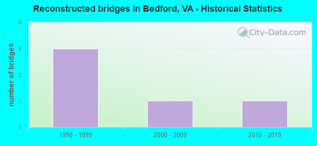
- Reconstructed bridges - Historical Statistics
- 31990-1999
- 12000-2009
- 12010-2019
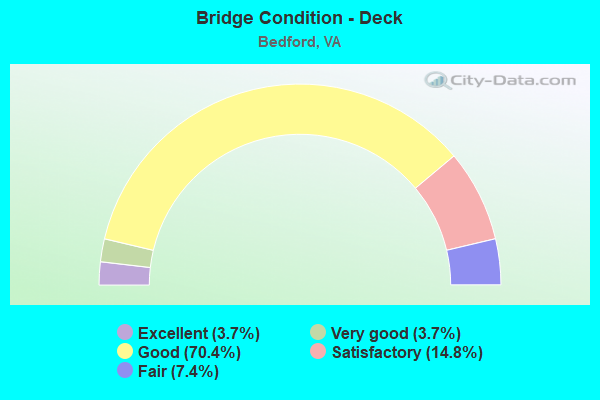
- Bridge Condition - Deck
- 3.7%Excellent
- 3.7%Very good
- 70.4%Good
- 14.8%Satisfactory
- 7.4%Fair

- Bridge Condition - Superstructure
- 7.4%Excellent
- 14.8%Very good
- 40.7%Good
- 18.5%Satisfactory
- 18.5%Fair
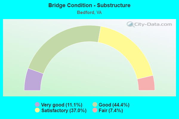
- Bridge Condition - Substructure
- 11.1%Very good
- 44.4%Good
- 37.0%Satisfactory
- 7.4%Fair
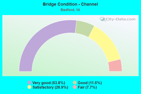
- Bridge Condition - Channel
- 53.8%Very good
- 11.5%Good
- 26.9%Satisfactory
- 7.7%Fair
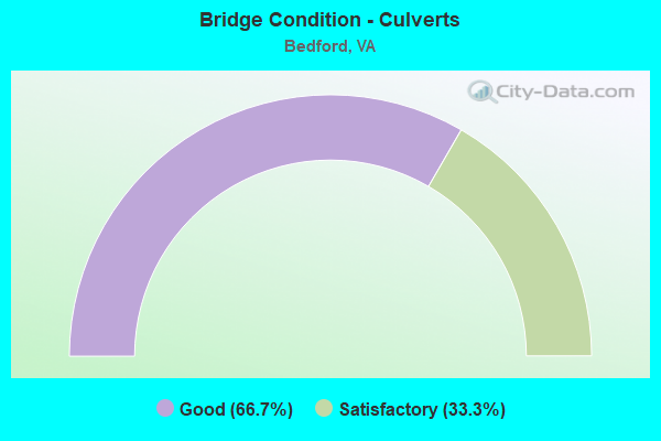
- Bridge Condition - Culverts
- 66.7%Good
- 33.3%Satisfactory
Find on map >> Show street view
Structure Number: 2592, Location: 0.20-RT 667; 0.50-RT 724 (Lat: 37.262061, Lng: -79.487181), Route carried "on" structure: State highway 43, Year Built: 1975, Status: Open, Structure Length: 2.41m (7.91ft), Average Daily Traffic: 1,534 (year 2020), Truck Traffic: 2%, Average Future Daily Traffic: 1,967 (year 2040), Design Load: HS 20+Mod, Features Intersected: MACHINE CREEK
Minimum Vertical Clearance: 30+ m (98+ ft), Kilometerpoint: 36.460, Lanes on structure: 2, Owner: State Highway Agency, Approaching Roadway Width: 11.6m (38.1ft), Skew: 1 degrees, Material/Design: Steel, Design/Construction: Stringer/Multi-beam, Number Of Spans In Main Unit: 1, Length of Maximum Span: 24.1m (79.1ft), Curb-To-Curb Width: 11.6m (38.1ft), Out-to-Out Width: 12.8m (42.0ft)
Condition: Deck: Satisfactory, Superstructure: Good, Substructure: Good, Channel: Good, Operating Rating: 79.8 metric tons, Method Used To Determine Operating Rating: Load and Resistance Factor (LRFR), Inventory Rating: 61.7 metric tons, Method Used To Determine Inventory Rating: Load and Resistance Factor (LRFR), Structural Evaluation: Better than present minimum criteria, Deck Geometry: Equal to present minimum criteria, Waterway Adequacy: Better than present minimum criteria, Approach Roadway Alignment: Better than present minimum criteria, Designated Inspection Frequency: Every 24 months, Inspection Date: June 2021, Deck Structure Type: Concrete Cast-file-Place
Find on map >> Show street view
Structure Number: 2593, Location: 0.18 Rt 724; 0.62 Rt 723 (Lat: 37.274017, Lng: -79.491494), Route carried "on" structure: State highway 43, Year Built: 1974, Status: Open, Structure Length: 0.64m (2.10ft), Average Daily Traffic: 1,534 (year 2020), Truck Traffic: 2%, Average Future Daily Traffic: 1,967 (year 2040), Design Load: HS 20+Mod, Features Intersected: Ninninger Creek
Minimum Vertical Clearance: 30+ m (98+ ft), Kilometerpoint: 37.828, Lanes on structure: 2, Owner: State Highway Agency, Approaching Roadway Width: 6.1m (20.0ft), Skew: 2 degrees, Material/Design: Concrete, Design/Construction: Culvert, Number Of Spans In Main Unit: 2, Length of Maximum Span: 3.0m (9.8ft)
Condition: Channel: Satisfactory, Culverts: Satisfactory, Operating Rating: 89.8 metric tons, Method Used To Determine Operating Rating: Field evaluation and documented engineering judgment, Inventory Rating: 89.8 metric tons, Method Used To Determine Inventory Rating: Field evaluation and documented engineering judgment, Structural Evaluation: Equal to present minimum criteria, Waterway Adequacy: Better than present minimum criteria, Approach Roadway Alignment: Equal to present desirable criteria, Length Of Structure Improvement: 0.64m (2.10ft), Designated Inspection Frequency: Every 24 months, Inspection Date: March 2021, Bridge Improvement Cost: $302,000, Roadway Improvement Cost: $106,000, Total Project Cost: $1,012,000 ( Estimate for 2021)
Find on map >> Show street view
Structure Number: 2603, Location: 0.91 Rt 644; 0.40 Bedfd. (Lat: 37.361286, Lng: -79.500639), Route carried "on" structure: State highway 122, Year Built: 1937, Status: Open, Structure Length: 2.99m (9.81ft), Average Daily Traffic: 2,694 (year 2020), Truck Traffic: 6%, Average Future Daily Traffic: 3,563 (year 2040), Design Load: H 15, Features Intersected: Little Otter River
Minimum Vertical Clearance: 30+ m (98+ ft), Kilometerpoint: 62.239, Lanes on structure: 2, Base Highway Network: Yes, Owner: State Highway Agency, Approaching Roadway Width: 6.1m (20.0ft), Material/Design: Concrete, Design/Construction: Tee Beam, Number Of Spans In Main Unit: 3, Length of Maximum Span: 10.1m (33.1ft), Curb or Sidewalk Widths: Left: 0.2m (0.7ft), Right: 0.2m (0.7ft), Curb-To-Curb Width: 7.0m (23.0ft), Out-to-Out Width: 7.9m (25.9ft)
Condition: Deck: Satisfactory, Superstructure: Satisfactory, Substructure: Satisfactory, Channel: Very good, Operating Rating: 40.8 metric tons, Method Used To Determine Operating Rating: Load and Resistance Factor (LRFR), Inventory Rating: 30.8 metric tons, Method Used To Determine Inventory Rating: Load and Resistance Factor (LRFR), Structural Evaluation: Equal to present minimum criteria, Deck Geometry: High priority of replacement, Waterway Adequacy: Equal to present minimum criteria, Approach Roadway Alignment: Equal to present desirable criteria, Length Of Structure Improvement: 2.99m (9.81ft), Designated Inspection Frequency: Every 24 months, Inspection Date: April 2020, Bridge Improvement Cost: $1,393,000, Roadway Improvement Cost: $488,000, Total Project Cost: $4,527,000 ( Estimate for 2018), Deck Structure Type: Concrete Cast-file-Place, Wearing Surface/Protective System: Wearing Surface: Bituminous
Find on map >> Show street view
Structure Number: 2622, Location: 0.92-RT 799;1.11-RT 671 (Lat: 37.351736, Lng: -79.475522), Route carried "on" structure: US 221, Year Built: 1953, Year Reconstructed: 2004, Status: Posted for load, Structure Length: 4.63m (15.19ft), Average Daily Traffic: 5,105 (year 2020), Truck Traffic: 4%, Average Future Daily Traffic: 5,616 (year 2040), Design Load: HS 20, Features Intersected: LITTLE OTTER RIVER, Facility Carried by Structure: FOREST RD.
Minimum Vertical Clearance: 30+ m (98+ ft), Kilometerpoint: 209.540, Lanes on structure: 2, Base Highway Network: Yes, Owner: State Highway Agency, Approaching Roadway Width: 7.3m (24.0ft), Skew: 1 degrees, Material/Design: Steel, Design/Construction: Stringer/Multi-beam, Number Of Spans In Main Unit: 1, Number Of Approach Spans: 2, Length of Maximum Span: 21.3m (69.9ft), Curb or Sidewalk Widths: Left: 0.5m (1.6ft), Right: 0.5m (1.6ft), Curb-To-Curb Width: 8.5m (27.9ft), Out-to-Out Width: 10.1m (33.1ft)
Condition: Deck: Fair, Superstructure: Fair, Substructure: Satisfactory, Channel: Fair, Operating Rating: 39.0 metric tons, Method Used To Determine Operating Rating: Load and Resistance Factor (LRFR), Inventory Rating: 29.9 metric tons, Method Used To Determine Inventory Rating: Load and Resistance Factor (LRFR), Structural Evaluation: Somewhat better than minimum adequacy, Deck Geometry: High priority of replacement, Waterway Adequacy: Better than present minimum criteria, Approach Roadway Alignment: Equal to present minimum criteria, Length Of Structure Improvement: 5.49m (18.01ft), Designated Inspection Frequency: Every 24 months, Inspection Date: August 2020, Bridge Improvement Cost: $3,451,000, Roadway Improvement Cost: $1,208,000, Total Project Cost: $11,561,000 ( Estimate for 2019), Deck Structure Type: Concrete Cast-file-Place, Wearing Surface/Protective System: Wearing Surface: Latex Concrete
Find on map >> Show street view
Structure Number: 2652, Location: 8.88 CAMPB;3.40 RT 460BUS (Lat: 37.317778, Lng: -79.444186), Route carried "on" structure: US 460, Year Built: 1971, Status: Open, Structure Length: 3.95m (12.96ft), Average Daily Traffic: 7,135 (year 2020), Truck Traffic: 9%, Average Future Daily Traffic: 9,989 (year 2040), Design Load: HS 20+Mod, Features Intersected: LITTLE OTTER RIVER
Minimum Vertical Clearance: 30+ m (98+ ft), Kilometerpoint: 300.474, Lanes on structure: 2, Base Highway Network: Yes, Owner: State Highway Agency, Approaching Roadway Width: 7.9m (25.9ft), Material/Design: Steel, Design/Construction: Stringer/Multi-beam, Number Of Spans In Main Unit: 3, Length of Maximum Span: 13.4m (44.0ft), Curb-To-Curb Width: 11.6m (38.1ft), Out-to-Out Width: 12.8m (42.0ft)
Condition: Deck: Satisfactory, Superstructure: Good, Substructure: Satisfactory, Channel: Good, Operating Rating: 57.2 metric tons, Method Used To Determine Operating Rating: Load and Resistance Factor (LRFR), Inventory Rating: 43.5 metric tons, Method Used To Determine Inventory Rating: Load and Resistance Factor (LRFR), Structural Evaluation: Equal to present minimum criteria, Deck Geometry: Better than present minimum criteria, Waterway Adequacy: Equal to present desirable criteria, Approach Roadway Alignment: Equal to present desirable criteria, Designated Inspection Frequency: Every 24 months, Inspection Date: January 2022, Deck Structure Type: Concrete Cast-file-Place, Wearing Surface/Protective System: Wearing Surface: Latex Concrete
Find on map >> Show street view
Structure Number: 2735, Location: 0.40 Rt 122; 1.00 Rt 682 (Lat: 37.392733, Lng: -79.510950), Route carried "on" structure: County highway 640, Year Built: 1932, Status: Open, Structure Length: 0.98m (3.22ft), Average Daily Traffic: 541 (year 2016), Average Future Daily Traffic: 679 (year 2040), Design Load: HL 93, Features Intersected: Br. of Big Otter River
Minimum Vertical Clearance: 30+ m (98+ ft), Kilometerpoint: 0.634, Lanes on structure: 1, Owner: State Highway Agency, Approaching Roadway Width: 4.9m (16.1ft), Material/Design: Concrete, Design/Construction: Slab, Number Of Spans In Main Unit: 1, Length of Maximum Span: 9.2m (30.2ft), Curb or Sidewalk Widths: Left: 0.1m (0.3ft), Right: 0.1m (0.3ft), Curb-To-Curb Width: 4.7m (15.4ft), Out-to-Out Width: 4.9m (16.1ft)
Condition: Deck: Good, Superstructure: Good, Substructure: Good, Channel: Very good, Operating Rating: 80.7 metric tons, Method Used To Determine Operating Rating: Load and Resistance Factor (LRFR), Inventory Rating: 62.6 metric tons, Method Used To Determine Inventory Rating: Load and Resistance Factor (LRFR), Structural Evaluation: Better than present minimum criteria, Deck Geometry: High priority of replacement, Waterway Adequacy: Better than present minimum criteria, Approach Roadway Alignment: High priority of corrective action, Designated Inspection Frequency: Every 24 months, Inspection Date: August 2021, Deck Structure Type: Other, Wearing Surface/Protective System: Wearing Surface: Bituminous, Membrane: Epoxy
Find on map >> Show street view
Structure Number: 274, Location: 0.40 Rt 640; 0.10 Rt 43 (Lat: 37.403728, Lng: -79.553897), Route carried "on" structure: County highway 643, Year Built: 1932, Status: Posted for load, Structure Length: 1.26m (4.13ft), Average Daily Traffic: 753 (year 2020), Truck Traffic: 1%, Average Future Daily Traffic: 1,054 (year 2040), Features Intersected: Stony Ceek
Minimum Vertical Clearance: 30+ m (98+ ft), Kilometerpoint: 0.483, Lanes on structure: 2, Owner: State Highway Agency, Approaching Roadway Width: 5.4m (17.7ft), Material/Design: Concrete, Design/Construction: Slab, Number Of Spans In Main Unit: 3, Length of Maximum Span: 4.3m (14.1ft), Curb or Sidewalk Widths: Left: 0.1m (0.3ft), Right: 0.1m (0.3ft), Curb-To-Curb Width: 5.4m (17.7ft), Out-to-Out Width: 6.1m (20.0ft)
Condition: Deck: Good, Superstructure: Satisfactory, Substructure: Satisfactory, Channel: Fair, Operating Rating: 10.9 metric tons, Method Used To Determine Operating Rating: Load Factor (LF), Inventory Rating: 6.4 metric tons, Method Used To Determine Inventory Rating: Load Factor (LF), Structural Evaluation: High priority of corrective action, Deck Geometry: High priority of replacement, Waterway Adequacy: Equal to present minimum criteria, Approach Roadway Alignment: High priority of corrective action, Bridge Posting: Required (Relationship of Operating Rating to Maximum Legal Load: > 39.9% below), Length Of Structure Improvement: 1.28m (4.20ft), Designated Inspection Frequency: Every 12 months, Inspection Date: Febuary 2022, Bridge Improvement Cost: $420,000, Roadway Improvement Cost: $147,000, Total Project Cost: $1,365,000 ( Estimate for 2020), Deck Structure Type: Concrete Cast-file-Place, Wearing Surface/Protective System: Wearing Surface: Bituminous
Find on map >> Show street view
Structure Number: 2796, Location: 0.75 Rt 682; 0.70 Rt 681 (Lat: 37.381231, Lng: -79.601686), Route carried "on" structure: County highway 680, Year Built: 1976, Status: Open, Structure Length: 5.12m (16.80ft), Average Daily Traffic: 267 (year 2019), Average Future Daily Traffic: 317 (year 2040), Features Intersected: Big Otter River
Minimum Vertical Clearance: 30+ m (98+ ft), Kilometerpoint: 13.258, Lanes on structure: 2, Owner: State Highway Agency, Approaching Roadway Width: 5.5m (18.0ft), Skew: 1 degrees, Material/Design: Steel, Design/Construction: Stringer/Multi-beam, Number Of Spans In Main Unit: 3, Length of Maximum Span: 17.1m (56.1ft), Curb-To-Curb Width: 7.9m (25.9ft), Out-to-Out Width: 9.1m (29.9ft)
Condition: Deck: Good, Superstructure: Good, Substructure: Satisfactory, Channel: Satisfactory, Operating Rating: 61.7 metric tons, Method Used To Determine Operating Rating: Load and Resistance Factor (LRFR), Inventory Rating: 47.2 metric tons, Method Used To Determine Inventory Rating: Load and Resistance Factor (LRFR), Structural Evaluation: Equal to present minimum criteria, Deck Geometry: Somewhat better than minimum adequacy, Waterway Adequacy: Better than present minimum criteria, Approach Roadway Alignment: Equal to present desirable criteria, Designated Inspection Frequency: Every 24 months, Inspection Date: January 2021, Deck Structure Type: Concrete Cast-file-Place, Wearing Surface/Protective System: Wearing Surface: Epoxy Overlay
Find on map >> Show street view
Structure Number: 2799, Location: 0.10 Rt 460; 2.90 Rt 681 (Lat: 37.344817, Lng: -79.565397), Route carried "on" structure: County highway 680, Year Built: 1972, Status: Open, Structure Length: 0.85m (2.79ft), Average Daily Traffic: 504 (year 2016), Average Future Daily Traffic: 564 (year 2040), Design Load: H 20, Features Intersected: Br of Little Otter River
Minimum Vertical Clearance: 30+ m (98+ ft), Kilometerpoint: 7.466, Lanes on structure: 2, Owner: State Highway Agency, Approaching Roadway Width: 5.5m (18.0ft), Skew: 9 degrees, Material/Design: Steel, Design/Construction: Culvert, Number Of Spans In Main Unit: 2, Length of Maximum Span: 2.7m (8.9ft)
Condition: Channel: Very good, Culverts: Good, Operating Rating: 44.5 metric tons, Method Used To Determine Operating Rating: Field evaluation and documented engineering judgment, Inventory Rating: 32.7 metric tons, Method Used To Determine Inventory Rating: Field evaluation and documented engineering judgment, Structural Evaluation: Better than present minimum criteria, Waterway Adequacy: Equal to present minimum criteria, Approach Roadway Alignment: Equal to present minimum criteria, Length Of Structure Improvement: 0.85m (2.79ft), Designated Inspection Frequency: Every 24 months, Inspection Date: August 2021, Bridge Improvement Cost: $402,000, Roadway Improvement Cost: $100,000, Total Project Cost: $1,285,000 ( Estimate for 2021)
Find on map >> Show street view
Structure Number: 281, Location: 2.70 Rt 691; 0.30 Rt 681 (Lat: 37.329178, Lng: -79.613944), Route carried "on" structure: County highway 684, Year Built: 1932, Status: Open, Structure Length: 0.73m (2.40ft), Average Daily Traffic: 454 (year 2019), Average Future Daily Traffic: 502 (year 2040), Features Intersected: Branch of Wolf Creek
Minimum Vertical Clearance: 30+ m (98+ ft), Kilometerpoint: 11.514, Lanes on structure: 2, Owner: State Highway Agency, Approaching Roadway Width: 5.5m (18.0ft), Skew: 3 degrees, Material/Design: Steel, Design/Construction: Stringer/Multi-beam, Number Of Spans In Main Unit: 1, Length of Maximum Span: 7.3m (24.0ft), Curb or Sidewalk Widths: Left: 0.2m (0.7ft), Right: 0.2m (0.7ft), Curb-To-Curb Width: 7.0m (23.0ft), Out-to-Out Width: 7.3m (24.0ft)
Condition: Deck: Good, Superstructure: Very good, Substructure: Good, Channel: Satisfactory, Operating Rating: 53.5 metric tons, Method Used To Determine Operating Rating: Load Factor (LF), Inventory Rating: 31.8 metric tons, Method Used To Determine Inventory Rating: Load Factor (LF), Structural Evaluation: Better than present minimum criteria, Deck Geometry: Meets minimum limits, Waterway Adequacy: Somewhat better than minimum adequacy, Approach Roadway Alignment: Equal to present minimum criteria, Designated Inspection Frequency: Every 24 months, Inspection Date: April 2020, Deck Structure Type: Wood or Timber, Wearing Surface/Protective System: Wearing Surface: Bituminous
Find on map >> Show street view
Structure Number: 2842, Location: 0.90 RT 813; 0.30 RT 715 (Lat: 37.278272, Lng: -79.446506), Route carried "on" structure: County highway 714, Year Built: 1989, Status: Open, Structure Length: 4.63m (15.19ft), Average Daily Traffic: 587 (year 2020), Truck Traffic: 5%, Average Future Daily Traffic: 673 (year 2040), Features Intersected: MACHINE CREEK
Minimum Vertical Clearance: 30+ m (98+ ft), Kilometerpoint: 7.208, Lanes on structure: 2, Owner: State Highway Agency, Approaching Roadway Width: 6.7m (22.0ft), Skew: 2 degrees, Material/Design: Steel, Design/Construction: Stringer/Multi-beam, Number Of Spans In Main Unit: 3, Length of Maximum Span: 15.5m (50.9ft), Curb-To-Curb Width: 9.0m (29.5ft), Out-to-Out Width: 10.0m (32.8ft)
Condition: Deck: Good, Superstructure: Good, Substructure: Good, Channel: Satisfactory, Operating Rating: 65.3 metric tons, Method Used To Determine Operating Rating: Load and Resistance Factor (LRFR), Inventory Rating: 49.9 metric tons, Method Used To Determine Inventory Rating: Load and Resistance Factor (LRFR), Structural Evaluation: Better than present minimum criteria, Deck Geometry: Somewhat better than minimum adequacy, Waterway Adequacy: Equal to present desirable criteria, Approach Roadway Alignment: Equal to present desirable criteria, Designated Inspection Frequency: Every 24 months, Inspection Date: May 2021, Deck Structure Type: Concrete Cast-file-Place, Wearing Surface/Protective System: Deck Protection: Epoxy Coated Reinforcing
Find on map >> Show street view
Structure Number: 2846, Location: 0.80-RTE 671;1.40-RTE 890 (Lat: 37.333319, Lng: -79.464661), Route carried "on" structure: County highway 718, Year Built: 1967, Year Reconstructed: 1998, Status: Open, Structure Length: 1.37m (4.49ft), Average Daily Traffic: 302 (year 2010), Average Future Daily Traffic: 317 (year 2040), Design Load: HS 20, Features Intersected: Little Otter River
Minimum Vertical Clearance: 30+ m (98+ ft), Kilometerpoint: 3.057, Lanes on structure: 2, Owner: State Highway Agency, Approaching Roadway Width: 5.2m (17.1ft), Skew: 1 degrees, Material/Design: Steel, Design/Construction: Stringer/Multi-beam, Number Of Spans In Main Unit: 1, Length of Maximum Span: 12.5m (41.0ft), Curb or Sidewalk Widths: Left: 0.3m (1.0ft), Right: 0.3m (1.0ft), Curb-To-Curb Width: 5.4m (17.7ft), Out-to-Out Width: 6.0m (19.7ft)
Condition: Deck: Good, Superstructure: Good, Substructure: Satisfactory, Channel: Very good, Operating Rating: 46.3 metric tons, Method Used To Determine Operating Rating: Load and Resistance Factor (LRFR), Inventory Rating: 35.4 metric tons, Method Used To Determine Inventory Rating: Load and Resistance Factor (LRFR), Structural Evaluation: Equal to present minimum criteria, Deck Geometry: High priority of replacement, Waterway Adequacy: Equal to present minimum criteria, Approach Roadway Alignment: High priority of corrective action, Length Of Structure Improvement: 1.37m (4.49ft), Designated Inspection Frequency: Every 24 months, Inspection Date: January 2022, Bridge Improvement Cost: $422,000, Roadway Improvement Cost: $148,000, Total Project Cost: $1,373,000 ( Estimate for 2016), Deck Structure Type: Wood or Timber, Wearing Surface/Protective System: Wearing Surface: Bituminous
Find on map >> Show street view
Structure Number: 2851, Location: 0.75 RT 714; 0.35 RT 43 (Lat: 37.287728, Lng: -79.485458), Route carried "on" structure: County highway 723, Year Built: 1989, Status: Open, Structure Length: 0.68m (2.23ft), Average Daily Traffic: 812 (year 2016), Average Future Daily Traffic: 1,202 (year 2040), Design Load: H 20, Features Intersected: Skinnells Creek
Minimum Vertical Clearance: 30+ m (98+ ft), Kilometerpoint: 6.372, Lanes on structure: 2, Owner: State Highway Agency, Approaching Roadway Width: 6.4m (21.0ft), Material/Design: Steel, Design/Construction: Culvert, Number Of Spans In Main Unit: 2, Length of Maximum Span: 3.2m (10.5ft)
Condition: Channel: Very good, Culverts: Good, Operating Rating: 89.8 metric tons, Method Used To Determine Operating Rating: Field evaluation and documented engineering judgment, Inventory Rating: 89.8 metric tons, Method Used To Determine Inventory Rating: Field evaluation and documented engineering judgment, Structural Evaluation: Better than present minimum criteria, Waterway Adequacy: Better than present minimum criteria, Approach Roadway Alignment: Better than present minimum criteria, Designated Inspection Frequency: Every 24 months, Inspection Date: January 2021
Find on map >> Show street view
Structure Number: 2916, Location: 0.50 Rt 714; 2.10 Rt 715 (Lat: 37.293439, Lng: -79.456267), Route carried "on" structure: County highway 784, Year Built: 1960, Status: Posted for load, Structure Length: 4.36m (14.30ft), Average Daily Traffic: 336 (year 2016), Average Future Daily Traffic: 425 (year 2040), Design Load: H 15, Features Intersected: Little Otter River, Facility Carried by Structure: Nicopolis Road
Minimum Vertical Clearance: 30+ m (98+ ft), Kilometerpoint: 0.761, Lanes on structure: 1, Owner: State Highway Agency, Approaching Roadway Width: 4.6m (15.1ft), Material/Design: Steel, Design/Construction: Truss - Thru, Number Of Spans In Main Unit: 1, Number Of Approach Spans: 1, Length of Maximum Span: 27.4m (89.9ft), Curb or Sidewalk Widths: Left: 0.2m (0.7ft), Right: 0.2m (0.7ft), Curb-To-Curb Width: 4.3m (14.1ft), Out-to-Out Width: 4.6m (15.1ft)
Condition: Deck: Satisfactory, Superstructure: Fair, Substructure: Good, Channel: Satisfactory, Operating Rating: 27.2 metric tons, Method Used To Determine Operating Rating: Load Factor (LF), Inventory Rating: 16.3 metric tons, Method Used To Determine Inventory Rating: Load Factor (LF), Structural Evaluation: Somewhat better than minimum adequacy, Deck Geometry: High priority of replacement, Waterway Adequacy: Equal to present minimum criteria, Approach Roadway Alignment: Equal to present minimum criteria, Length Of Structure Improvement: 4.36m (14.30ft), Designated Inspection Frequency: Every 12 months, Critical Feature Inspection Frequency: Every 12 months, Inspection Date: March 2021, Critical Feature Inspection Date: March 2021, Bridge Improvement Cost: $399,000, Roadway Improvement Cost: $100,000, Total Project Cost: $1,276,000 ( Estimate for 2019), Deck Structure Type: Concrete Cast-file-Place, Wearing Surface/Protective System: Wearing Surface: Latex Concrete
Find on map >> Show street view
Structure Number: 2918, Location: 1.75 Rt 714; 0.45 D End (Lat: 37.274406, Lng: -79.469733), Route carried "on" structure: County highway 804, Year Built: 1932, Status: Posted for load, Structure Length: 1.04m (3.41ft), Average Daily Traffic: 50 (year 2019), Average Future Daily Traffic: 71 (year 2040), Features Intersected: Nininger Creek
Minimum Vertical Clearance: 30+ m (98+ ft), Kilometerpoint: 0.714, Lanes on structure: 2, Owner: State Highway Agency, Approaching Roadway Width: 3.7m (12.1ft), Material/Design: Steel, Design/Construction: Stringer/Multi-beam, Number Of Spans In Main Unit: 1, Length of Maximum Span: 10.4m (34.1ft), Curb or Sidewalk Widths: Left: 0.2m (0.7ft), Right: 0.2m (0.7ft), Curb-To-Curb Width: 4.9m (16.1ft), Out-to-Out Width: 6.2m (20.3ft)
Condition: Deck: Good, Superstructure: Fair, Substructure: Satisfactory, Channel: Very good, Operating Rating: 35.4 metric tons, Method Used To Determine Operating Rating: Load Factor (LF), Inventory Rating: 20.9 metric tons, Method Used To Determine Inventory Rating: Load Factor (LF), Structural Evaluation: Somewhat better than minimum adequacy, Deck Geometry: High priority of corrective action, Waterway Adequacy: Equal to present minimum criteria, Approach Roadway Alignment: Equal to present minimum criteria, Length Of Structure Improvement: 1.22m (4.00ft), Designated Inspection Frequency: Every 24 months, Inspection Date: May 2021, Bridge Improvement Cost: $321,000, Roadway Improvement Cost: $112,000, Total Project Cost: $1,042,000 ( Estimate for 2015), Deck Structure Type: Wood or Timber
Find on map >> Show street view
Structure Number: 2919, Location: 1.90-RT 714;0.30-DEAD END (Lat: 37.272825, Lng: -79.468092), Route carried "on" structure: County highway 804, Year Built: 1987, Year Reconstructed: 2019, Status: Open, Structure Length: 1.55m (5.09ft), Average Daily Traffic: 50 (year 2019), Average Future Daily Traffic: 71 (year 2040), Design Load: HS 20, Features Intersected: Nininger Creek
Minimum Vertical Clearance: 30+ m (98+ ft), Kilometerpoint: 0.468, Lanes on structure: 1, Owner: State Highway Agency, Approaching Roadway Width: 3.0m (9.8ft), Material/Design: Steel, Design/Construction: Stringer/Multi-beam, Number Of Spans In Main Unit: 1, Length of Maximum Span: 15.5m (50.9ft), Curb or Sidewalk Widths: Left: 0.2m (0.7ft), Right: 0.2m (0.7ft), Curb-To-Curb Width: 4.8m (15.7ft), Out-to-Out Width: 5.2m (17.1ft)
Condition: Deck: Good, Superstructure: Excellent, Substructure: Good, Channel: Very good, Operating Rating: 78.0 metric tons, Method Used To Determine Operating Rating: Load and Resistance Factor (LRFR), Inventory Rating: 59.9 metric tons, Method Used To Determine Inventory Rating: Load and Resistance Factor (LRFR), Structural Evaluation: Better than present minimum criteria, Deck Geometry: Equal to present desirable criteria, Waterway Adequacy: Somewhat better than minimum adequacy, Approach Roadway Alignment: Equal to present minimum criteria, Designated Inspection Frequency: Every 24 months, Inspection Date: May 2021, Deck Structure Type: Wood or Timber
Find on map >> Show street view
Structure Number: 22404, Location: 0016122 0011122 (Lat: 37.335894, Lng: -79.522936), Route carried "on" structure: US 43, Year Built: 1907, Status: Open, Structure Length: 4.85m (15.91ft), Average Daily Traffic: 4,699 (year 2020), Truck Traffic: 2%, Average Future Daily Traffic: 5,169 (year 2040), Features Intersected: NS RAILWAY, Facility Carried by Structure: N BRIDGE STREET
Minimum Vertical Clearance: 30+ m (98+ ft), Kilometerpoint: 32.244, Lanes on structure: 2, Owner: Railroad, Maintenance Responsibility: Town or Township Highway Agency, Approaching Roadway Width: 13.4m (44.0ft), Material/Design: Concrete, Design/Construction: Arch - Deck, Number Of Spans In Main Unit: 1, Length of Maximum Span: 17.4m (57.1ft), Curb or Sidewalk Widths: Left: 1.8m (5.9ft), Right: 1.8m (5.9ft), Curb-To-Curb Width: 9.1m (29.9ft), Out-to-Out Width: 13.4m (44.0ft)
Condition: Deck: Good, Superstructure: Fair, Substructure: Satisfactory, Operating Rating: 38.1 metric tons, Method Used To Determine Operating Rating: Field evaluation and documented engineering judgment, Inventory Rating: 22.7 metric tons, Method Used To Determine Inventory Rating: Field evaluation and documented engineering judgment, Structural Evaluation: Somewhat better than minimum adequacy, Deck Geometry: Meets minimum limits, Underclear: Better than present minimum criteria, Approach Roadway Alignment: Equal to present minimum criteria, Designated Inspection Frequency: Every 24 months, Inspection Date: September 2021, Deck Structure Type: Other, Wearing Surface/Protective System: Wearing Surface: Bituminous
Find on map >> Show street view
Structure Number: 22405, Location: 0.16 Bedfrd; 1.00 Rt 460 (Lat: 37.322842, Lng: -79.515761), Route carried "on" structure: State highway 43, Year Built: 1970, Status: Open, Structure Length: 5.84m (19.16ft), Average Daily Traffic: 1,486 (year 2020), Truck Traffic: 2%, Average Future Daily Traffic: 1,681 (year 2040), Design Load: HS 20+Mod, Features Intersected: 460 & 122 Bypass
Minimum Vertical Clearance: 30+ m (98+ ft), Kilometerpoint: 45.052, Lanes on structure: 2, Lanes under structure: 4, Owner: State Highway Agency, Approaching Roadway Width: 7.3m (24.0ft), Material/Design: Steel continuous, Design/Construction: Stringer/Multi-beam, Number Of Spans In Main Unit: 2, Length of Maximum Span: 29.2m (95.8ft), Curb or Sidewalk Widths: Left: 1.5m (4.9ft), Right: 0.5m (1.6ft), Curb-To-Curb Width: 8.5m (27.9ft), Out-to-Out Width: 11.1m (36.4ft)
Condition: Deck: Good, Superstructure: Good, Substructure: Good, Operating Rating: 46.3 metric tons, Method Used To Determine Operating Rating: Load and Resistance Factor (LRFR), Inventory Rating: 35.4 metric tons, Method Used To Determine Inventory Rating: Load and Resistance Factor (LRFR), Structural Evaluation: Better than present minimum criteria, Deck Geometry: Somewhat better than minimum adequacy, Underclear: Somewhat better than minimum adequacy, Approach Roadway Alignment: Equal to present desirable criteria, Designated Inspection Frequency: Every 24 months, Inspection Date: August 2021, Deck Structure Type: Concrete Cast-file-Place, Wearing Surface/Protective System: Wearing Surface: Epoxy Overlay
Find on map >> Show street view
Structure Number: 22407, Location: 0.00NCL BEDF;0.00 BEDFO C (Lat: 37.355778, Lng: -79.535361), Route carried "on" structure: State highway 43, Year Built: 1952, Status: Open, Structure Length: 1.13m (3.71ft), Average Daily Traffic: 2,139 (year 2020), Truck Traffic: 1%, Average Future Daily Traffic: 2,984 (year 2040), Design Load: HS 15, Features Intersected: LITTLE OTTER RIVER
Minimum Vertical Clearance: 30+ m (98+ ft), Kilometerpoint: 49.734, Lanes on structure: 2, Owner: State Highway Agency, Approaching Roadway Width: 7.0m (23.0ft), Material/Design: Concrete, Design/Construction: Tee Beam, Number Of Spans In Main Unit: 1, Length of Maximum Span: 11.3m (37.1ft), Curb or Sidewalk Widths: Left: 0.5m (1.6ft), Right: 0.5m (1.6ft), Curb-To-Curb Width: 7.3m (24.0ft), Out-to-Out Width: 8.9m (29.2ft)
Condition: Deck: Fair, Superstructure: Fair, Substructure: Fair, Channel: Good, Operating Rating: 44.5 metric tons, Method Used To Determine Operating Rating: Load Factor (LF), Inventory Rating: 26.3 metric tons, Method Used To Determine Inventory Rating: Load Factor (LF), Structural Evaluation: Somewhat better than minimum adequacy, Deck Geometry: High priority of replacement, Waterway Adequacy: Equal to present minimum criteria, Approach Roadway Alignment: Equal to present minimum criteria, Length Of Structure Improvement: 1.77m (5.81ft), Designated Inspection Frequency: Every 24 months, Inspection Date: August 2021, Bridge Improvement Cost: $771,000, Roadway Improvement Cost: $270,000, Total Project Cost: $2,583,000 ( Estimate for 2021), Deck Structure Type: Concrete Cast-file-Place, Wearing Surface/Protective System: Wearing Surface: Bituminous
Find on map >> Show street view
Structure Number: 22408, Location: 0.50 Bedfrd; 0.91 Rt 221 (Lat: 37.323636, Lng: -79.532644), Route carried "on" structure: State highway 122, Year Built: 1970, Status: Open, Structure Length: 5.49m (18.01ft), Average Daily Traffic: 3,803 (year 2020), Truck Traffic: 4%, Average Future Daily Traffic: 3,960 (year 2040), Design Load: HS 20+Mod, Features Intersected: 460 Bypass
Minimum Vertical Clearance: 30+ m (98+ ft), Kilometerpoint: 54.449, Lanes on structure: 4, Lanes under structure: 4, Owner: State Highway Agency, Approaching Roadway Width: 15.8m (51.8ft), Skew: 22 degrees, Material/Design: Steel, Design/Construction: Stringer/Multi-beam, Number Of Spans In Main Unit: 2, Length of Maximum Span: 27.7m (90.9ft), Curb or Sidewalk Widths: Left: 1.5m (4.9ft), Right: 1.5m (4.9ft), Curb-To-Curb Width: 14.6m (47.9ft), Out-to-Out Width: 19.5m (64.0ft)
Condition: Deck: Good, Superstructure: Satisfactory, Substructure: Good, Operating Rating: 68.9 metric tons, Method Used To Determine Operating Rating: Load and Resistance Factor (LRFR), Inventory Rating: 53.5 metric tons, Method Used To Determine Inventory Rating: Load and Resistance Factor (LRFR), Structural Evaluation: Equal to present minimum criteria, Deck Geometry: High priority of replacement, Underclear: Somewhat better than minimum adequacy, Approach Roadway Alignment: Equal to present desirable criteria, Length Of Structure Improvement: 5.49m (18.01ft), Designated Inspection Frequency: Every 24 months, Inspection Date: July 2021, Bridge Improvement Cost: $5,396,000, Roadway Improvement Cost: $1,619,000, Total Project Cost: $17,267,000 ( Estimate for 2018), Deck Structure Type: Concrete Cast-file-Place, Wearing Surface/Protective System: Wearing Surface: Bituminous
Find on map >> Show street view
Structure Number: 22412, Location: 1.10-Rt 122; 0.12-Rt 221W (Lat: 37.335517, Lng: -79.544131), Route carried "on" structure: Bypass US 460, Year Built: 1970, Year Reconstructed: 2000, Status: Open, Structure Length: 4.53m (14.86ft), Average Daily Traffic: 6,859 (year 2020), Truck Traffic: 9%, Average Future Daily Traffic: 9,604 (year 2040), Design Load: HS 20+Mod, Features Intersected: 221 NBL; 460 BUS. EBL
Minimum Vertical Clearance: 30+ m (98+ ft), Kilometerpoint: 290.071, Lanes on structure: 2, Lanes under structure: 2, Base Highway Network: Yes, Owner: State Highway Agency, Approaching Roadway Width: 11.9m (39.0ft), Skew: 4 degrees, Material/Design: Steel, Design/Construction: Stringer/Multi-beam, Number Of Spans In Main Unit: 3, Length of Maximum Span: 17.7m (58.1ft), Curb or Sidewalk Widths: Left: 0.2m (0.7ft), Right: 0.2m (0.7ft), Curb-To-Curb Width: 12.0m (39.4ft), Out-to-Out Width: 13.0m (42.7ft)
Condition: Deck: Good, Superstructure: Good, Substructure: Satisfactory, Operating Rating: 69.9 metric tons, Method Used To Determine Operating Rating: Load and Resistance Factor (LRFR), Inventory Rating: 53.5 metric tons, Method Used To Determine Inventory Rating: Load and Resistance Factor (LRFR), Structural Evaluation: Equal to present minimum criteria, Deck Geometry: Better than present minimum criteria, Approach Roadway Alignment: Equal to present minimum criteria, Designated Inspection Frequency: Every 24 months, Inspection Date: July 2021, Deck Structure Type: Concrete Cast-file-Place, Wearing Surface/Protective System: Wearing Surface: Latex Concrete
Find on map >> Show street view
Structure Number: 22414, Location: 0.22-BEDFORD L;0.71-RT 43 (Lat: 37.324881, Lng: -79.503322), Route carried "on" structure: Bypass US 460, Year Built: 1970, Status: Open, Structure Length: 4.32m (14.17ft), Average Daily Traffic: 7,135 (year 2020), Truck Traffic: 11%, Average Future Daily Traffic: 9,989 (year 2040), Design Load: HS 20+Mod, Features Intersected: 460 BUS
Minimum Vertical Clearance: 30+ m (98+ ft), Kilometerpoint: 294.688, Lanes on structure: 2, Lanes under structure: 4, Base Highway Network: Yes, Owner: State Highway Agency, Approaching Roadway Width: 7.3m (24.0ft), Skew: 1 degrees, Material/Design: Steel, Design/Construction: Stringer/Multi-beam, Number Of Spans In Main Unit: 3, Length of Maximum Span: 21.2m (69.6ft), Curb-To-Curb Width: 11.9m (39.0ft), Out-to-Out Width: 13.1m (43.0ft)
Condition: Deck: Good, Superstructure: Satisfactory, Substructure: Satisfactory, Operating Rating: 67.1 metric tons, Method Used To Determine Operating Rating: Load and Resistance Factor (LRFR), Inventory Rating: 51.7 metric tons, Method Used To Determine Inventory Rating: Load and Resistance Factor (LRFR), Structural Evaluation: Equal to present minimum criteria, Deck Geometry: Better than present minimum criteria, Approach Roadway Alignment: Equal to present desirable criteria, Designated Inspection Frequency: Every 24 months, Inspection Date: August 2021, Deck Structure Type: Concrete Cast-file-Place, Wearing Surface/Protective System: Wearing Surface: Latex Concrete
Find on map >> Show street view
Structure Number: 22416, Location: 0.22-BEDFORD L;0.71-RT 43 (Lat: 37.324706, Lng: -79.503297), Route carried "on" structure: Bypass US 460, Year Built: 1970, Year Reconstructed: 2003, Status: Open, Structure Length: 4.32m (14.17ft), Average Daily Traffic: 7,135 (year 2020), Truck Traffic: 9%, Average Future Daily Traffic: 9,989 (year 2040), Design Load: HS 20+Mod, Features Intersected: 460 Business
Minimum Vertical Clearance: 30+ m (98+ ft), Kilometerpoint: 294.688, Lanes on structure: 2, Lanes under structure: 2, Base Highway Network: Yes, Owner: State Highway Agency, Approaching Roadway Width: 11.9m (39.0ft), Skew: 1 degrees, Material/Design: Steel, Design/Construction: Stringer/Multi-beam, Number Of Spans In Main Unit: 3, Length of Maximum Span: 21.2m (69.6ft), Curb-To-Curb Width: 11.9m (39.0ft), Out-to-Out Width: 13.1m (43.0ft)
Condition: Deck: Good, Superstructure: Satisfactory, Substructure: Fair, Operating Rating: 67.1 metric tons, Method Used To Determine Operating Rating: Load and Resistance Factor (LRFR), Inventory Rating: 51.7 metric tons, Method Used To Determine Inventory Rating: Load and Resistance Factor (LRFR), Structural Evaluation: Somewhat better than minimum adequacy, Deck Geometry: Equal to present minimum criteria, Approach Roadway Alignment: Equal to present desirable criteria, Length Of Structure Improvement: 4.33m (14.21ft), Designated Inspection Frequency: Every 24 months, Inspection Date: July 2021, Bridge Improvement Cost: $1,847,000, Roadway Improvement Cost: $646,000, Total Project Cost: $6,002,000 ( Estimate for 2015), Deck Structure Type: Concrete Cast-file-Place, Wearing Surface/Protective System: Wearing Surface: Latex Concrete
Find on map >> Show street view
Structure Number: 24352, Location: 0.87 RT.460;0.91 RT. 221 (Lat: 37.337233, Lng: -79.496425), Route carried "on" structure: Bypass State highway 122, Year Built: 1990, Status: Open, Structure Length: 1.49m (4.89ft), Average Daily Traffic: 10,044 (year 2020), Truck Traffic: 5%, Average Future Daily Traffic: 14,062 (year 2040), Design Load: HS 20+Mod, Features Intersected: RT.122 OVER JOHNS CREEK
Minimum Vertical Clearance: 30+ m (98+ ft), Kilometerpoint: 0.000, Lanes on structure: 2, Owner: Town or Township Highway Agency, Approaching Roadway Width: 15.8m (51.8ft), Skew: 3 degrees, Material/Design: Concrete, Design/Construction: Culvert, Number Of Spans In Main Unit: 4, Length of Maximum Span: 3.0m (9.8ft), Curb-To-Curb Width: 15.8m (51.8ft), Out-to-Out Width: 15.9m (52.2ft)
Condition: Channel: Satisfactory, Culverts: Satisfactory, Operating Rating: 54.4 metric tons, Method Used To Determine Operating Rating: Field evaluation and documented engineering judgment, Inventory Rating: 32.7 metric tons, Method Used To Determine Inventory Rating: Field evaluation and documented engineering judgment, Structural Evaluation: Equal to present minimum criteria, Deck Geometry: Superior to present desirable criteria, Waterway Adequacy: Equal to present desirable criteria, Approach Roadway Alignment: Equal to present desirable criteria, Designated Inspection Frequency: Every 24 months, Inspection Date: September 2021
Find on map >> Show street view
Structure Number: 24353, Location: 1.31 MI; 460BUS;0.47MI221 (Lat: 37.342469, Lng: -79.500753), Route carried "on" structure: Bypass State highway 122, Year Built: 1990, Status: Open, Structure Length: 0.64m (2.10ft), Average Daily Traffic: 8,598 (year 2020), Truck Traffic: 5%, Average Future Daily Traffic: 12,037 (year 2040), Design Load: HS 20+Mod, Features Intersected: RTE.122 OVER STREAM
Minimum Vertical Clearance: 30+ m (98+ ft), Kilometerpoint: 0.000, Lanes on structure: 2, Owner: Town or Township Highway Agency, Approaching Roadway Width: 7.6m (24.9ft), Material/Design: Concrete, Design/Construction: Culvert, Number Of Spans In Main Unit: 2, Length of Maximum Span: 3.0m (9.8ft)
Condition: Channel: Satisfactory, Culverts: Good, Operating Rating: 89.8 metric tons, Method Used To Determine Operating Rating: Field evaluation and documented engineering judgment, Inventory Rating: 89.8 metric tons, Method Used To Determine Inventory Rating: Field evaluation and documented engineering judgment, Structural Evaluation: Better than present minimum criteria, Waterway Adequacy: Equal to present desirable criteria, Approach Roadway Alignment: Equal to present desirable criteria, Designated Inspection Frequency: Every 24 months, Inspection Date: September 2021
Find on map >> Show street view
Structure Number: 24725, Location: 0.90 Rt 786; 0.40 Rt 718 (Lat: 37.346208, Lng: -79.455814), Route carried "on" structure: County highway 671, Year Built: 1996, Status: Open, Structure Length: 4.85m (15.91ft), Average Daily Traffic: 1,088 (year 2020), Truck Traffic: 4%, Average Future Daily Traffic: 1,523 (year 2040), Features Intersected: Norfolk Southern RR
Minimum Vertical Clearance: 30+ m (98+ ft), Kilometerpoint: 5.541, Lanes on structure: 2, Owner: State Highway Agency, Approaching Roadway Width: 7.9m (25.9ft), Skew: 2 degrees, Material/Design: Steel, Design/Construction: Stringer/Multi-beam, Number Of Spans In Main Unit: 1, Length of Maximum Span: 48.5m (159.1ft), Curb-To-Curb Width: 8.5m (27.9ft), Out-to-Out Width: 9.5m (31.2ft)
Condition: Deck: Good, Superstructure: Good, Substructure: Good, Operating Rating: 82.6 metric tons, Method Used To Determine Operating Rating: Load and Resistance Factor (LRFR), Inventory Rating: 63.5 metric tons, Method Used To Determine Inventory Rating: Load and Resistance Factor (LRFR), Structural Evaluation: Better than present minimum criteria, Deck Geometry: Somewhat better than minimum adequacy, Underclear: Meets minimum limits, Approach Roadway Alignment: Equal to present desirable criteria, Designated Inspection Frequency: Every 24 months, Inspection Date: October 2020, Deck Structure Type: Concrete Cast-file-Place, Wearing Surface/Protective System: Deck Protection: Epoxy Coated Reinforcing
Find on map >> Show street view
Structure Number: 25433, Location: 1.7 Rt 825; .60 Rt 715 (Lat: 37.317972, Lng: -79.444258), Route carried "on" structure: US 460, Year Built: 1998, Status: Open, Structure Length: 4.36m (14.30ft), Average Daily Traffic: 7,135 (year 2020), Truck Traffic: 8%, Average Future Daily Traffic: 9,989 (year 2040), Design Load: HS 20+Mod, Features Intersected: LITTLE OTTER RIVER
Minimum Vertical Clearance: 30+ m (98+ ft), Kilometerpoint: 299.338, Lanes on structure: 2, Base Highway Network: Yes, Owner: State Highway Agency, Approaching Roadway Width: 9.1m (29.9ft), Material/Design: Steel continuous, Design/Construction: Stringer/Multi-beam, Number Of Spans In Main Unit: 3, Length of Maximum Span: 18.6m (61.0ft), Curb-To-Curb Width: 12.0m (39.4ft), Out-to-Out Width: 12.6m (41.3ft)
Condition: Deck: Good, Superstructure: Very good, Substructure: Good, Channel: Very good, Operating Rating: 73.5 metric tons, Method Used To Determine Operating Rating: Load and Resistance Factor (LRFR), Inventory Rating: 56.2 metric tons, Method Used To Determine Inventory Rating: Load and Resistance Factor (LRFR), Structural Evaluation: Better than present minimum criteria, Deck Geometry: Better than present minimum criteria, Waterway Adequacy: Equal to present desirable criteria, Approach Roadway Alignment: Equal to present desirable criteria, Designated Inspection Frequency: Every 24 months, Inspection Date: July 2020, Deck Structure Type: Concrete Cast-file-Place, Wearing Surface/Protective System: Deck Protection: Epoxy Coated Reinforcing
Find on map >> Show street view
Structure Number: 27837, Location: .14 Rte 43; 1.42 Rte 722 (Lat: 37.282200, Lng: -79.496367), Route carried "on" structure: County highway 723, Year Built: 2008, Status: Open, Structure Length: 1.22m (4.00ft), Average Daily Traffic: 58 (year 2019), Average Future Daily Traffic: 82 (year 2040), Design Load: HS 20+Mod, Features Intersected: Nininger Creek
Minimum Vertical Clearance: 30+ m (98+ ft), Kilometerpoint: 5.020, Lanes on structure: 2, Owner: State Highway Agency, Approaching Roadway Width: 6.7m (22.0ft), Material/Design: Concrete, Design/Construction: Slab, Number Of Spans In Main Unit: 1, Length of Maximum Span: 11.3m (37.1ft), Curb-To-Curb Width: 6.7m (22.0ft), Out-to-Out Width: 7.7m (25.3ft)
Condition: Deck: Good, Superstructure: Good, Substructure: Very good, Channel: Very good, Operating Rating: 89.8 metric tons, Method Used To Determine Operating Rating: Load and Resistance Factor (LRFR), Inventory Rating: 70.8 metric tons, Method Used To Determine Inventory Rating: Load and Resistance Factor (LRFR), Structural Evaluation: Better than present minimum criteria, Deck Geometry: Somewhat better than minimum adequacy, Waterway Adequacy: Better than present minimum criteria, Approach Roadway Alignment: Equal to present desirable criteria, Designated Inspection Frequency: Every 24 months, Inspection Date: October 2020, Deck Structure Type: Concrete Cast-file-Place, Wearing Surface/Protective System: Deck Protection: Epoxy Coated Reinforcing
Find on map >> Show street view
Structure Number: 29543, Location: 0.10 Rte 640; 2.68 NCL BD (Lat: 37.392744, Lng: -79.504633), Route carried "on" structure: State highway 122, Year Built: 2021, Status: Open, Structure Length: 7.12m (23.36ft), Average Daily Traffic: 2,694 (year 2020), Truck Traffic: 6%, Average Future Daily Traffic: 3,563 (year 2040), Design Load: HL 93, Features Intersected: Big Otter River, Facility Carried by Structure: Big Island Hwy
Minimum Vertical Clearance: 30+ m (98+ ft), Kilometerpoint: 65.903, Lanes on structure: 2, Base Highway Network: Yes, Owner: State Highway Agency, Approaching Roadway Width: 6.9m (22.6ft), Material/Design: Steel continuous, Design/Construction: Stringer/Multi-beam, Number Of Spans In Main Unit: 3, Length of Maximum Span: 30.0m (98.4ft), Curb or Sidewalk Widths: Left: 0.4m (1.3ft), Right: 0.4m (1.3ft), Curb-To-Curb Width: 11.0m (36.1ft), Out-to-Out Width: 11.7m (38.4ft)
Condition: Deck: Excellent, Superstructure: Excellent, Substructure: Good, Channel: Very good, Operating Rating: 82.6 metric tons, Method Used To Determine Operating Rating: Load and Resistance Factor (LRFR), Inventory Rating: 63.5 metric tons, Method Used To Determine Inventory Rating: Load and Resistance Factor (LRFR), Structural Evaluation: Better than present minimum criteria, Deck Geometry: Somewhat better than minimum adequacy, Waterway Adequacy: Equal to present desirable criteria, Approach Roadway Alignment: Equal to present desirable criteria, Designated Inspection Frequency: Every 24 months, Inspection Date: December 2021, Deck Structure Type: Concrete Cast-file-Place, Wearing Surface/Protective System: Wearing Surface: Monolithic Concrete, Deck Protection: Other
Find on map >> Show street view
Structure Number: 29545, Location: 2.69 Bdfd; 0.00 Rte 682S (Lat: 37.389578, Lng: -79.551214), Route carried "on" structure: State highway 43, Year Built: 2018, Status: Open, Structure Length: 3.66m (12.01ft), Average Daily Traffic: 900 (year 2020), Average Future Daily Traffic: 1,260 (year 2040), Design Load: HL 93, Features Intersected: Big Otter River
Minimum Vertical Clearance: 30+ m (98+ ft), Kilometerpoint: 54.062, Lanes on structure: 1, Owner: State Highway Agency, Approaching Roadway Width: 12.1m (39.7ft), Skew: 1 degrees, Material/Design: Prestressed concrete, Design/Construction: Slab, Number Of Spans In Main Unit: 3, Length of Maximum Span: 12.2m (40.0ft), Curb or Sidewalk Widths: Left: 0.4m (1.3ft), Right: 0.4m (1.3ft), Curb-To-Curb Width: 12.1m (39.7ft), Out-to-Out Width: 12.8m (42.0ft)
Condition: Deck: Good, Superstructure: Very good, Substructure: Very good, Channel: Very good, Operating Rating: 63.5 metric tons, Method Used To Determine Operating Rating: Load and Resistance Factor (LRFR), Inventory Rating: 49.0 metric tons, Method Used To Determine Inventory Rating: Load and Resistance Factor (LRFR), Structural Evaluation: Equal to present desirable criteria, Deck Geometry: Better than present minimum criteria, Waterway Adequacy: Better than present minimum criteria, Approach Roadway Alignment: Equal to present minimum criteria, Designated Inspection Frequency: Every 24 months, Inspection Date: May 2020, Deck Structure Type: Concrete Cast-file-Place, Wearing Surface/Protective System: Wearing Surface: Monolithic Concrete, Deck Protection: Other
Find on map >> Show street view
Structure Number: 29549, Location: 0.30 Rt 682S;0.27 Rt 682N (Lat: 37.392808, Lng: -79.555125), Route carried "on" structure: State highway 43, Year Built: 2019, Status: Open, Structure Length: 1.68m (5.51ft), Average Daily Traffic: 1,800 (year 2020), Truck Traffic: 1%, Average Future Daily Traffic: 2,520 (year 2040), Design Load: HL 93, Features Intersected: Stoney Creek
Minimum Vertical Clearance: 30.45m (99.90ft), Kilometerpoint: 0.000, Lanes on structure: 2, Owner: State Highway Agency, Approaching Roadway Width: 8.0m (26.2ft), Skew: 3 degrees, Material/Design: Prestressed concrete, Design/Construction: Box Beam or Girders - Multiple, Number Of Spans In Main Unit: 1, Length of Maximum Span: 15.3m (50.2ft), Curb or Sidewalk Widths: Left: 0.5m (1.6ft), Right: 0.5m (1.6ft), Curb-To-Curb Width: 11.9m (39.0ft), Out-to-Out Width: 12.8m (42.0ft)
Condition: Deck: Very good, Superstructure: Very good, Substructure: Very good, Channel: Very good, Operating Rating: 89.8 metric tons, Method Used To Determine Operating Rating: Load and Resistance Factor (LRFR), Inventory Rating: 67.1 metric tons, Method Used To Determine Inventory Rating: Load and Resistance Factor (LRFR), Structural Evaluation: Equal to present desirable criteria, Deck Geometry: Equal to present minimum criteria, Waterway Adequacy: Somewhat better than minimum adequacy, Approach Roadway Alignment: Equal to present minimum criteria, Designated Inspection Frequency: Every 24 months, Inspection Date: November 2021, Deck Structure Type: Concrete Cast-file-Place, Wearing Surface/Protective System: Wearing Surface: Monolithic Concrete, Deck Protection: Other Coated Reinforcing
Find on map >> Show street view
Structure Number: 2955, Location: 0.01-Rte 673;0.50-Rte 675 (Lat: 37.386628, Lng: -79.465361), Route carried "on" structure: Alternate County highway 644, Year Built: 2021, Status: Open, Structure Length: 2.74m (8.99ft), Average Daily Traffic: 144 (year 2020), Truck Traffic: 3%, Average Future Daily Traffic: 280 (year 2038), Design Load: HL 93, Features Intersected: Big Otter River
Minimum Vertical Clearance: 30+ m (98+ ft), Kilometerpoint: 8.351, Lanes on structure: 2, Owner: State Highway Agency, Approaching Roadway Width: 6.5m (21.3ft), Material/Design: Steel continuous, Design/Construction: Stringer/Multi-beam, Number Of Spans In Main Unit: 1, Length of Maximum Span: 26.8m (87.9ft), Curb or Sidewalk Widths: Left: 0.4m (1.3ft), Right: 0.4m (1.3ft), Curb-To-Curb Width: 6.6m (21.7ft), Out-to-Out Width: 7.4m (24.3ft)
Condition: Deck: Good, Superstructure: Good, Substructure: Good, Channel: Very good, Operating Rating: 67.1 metric tons, Method Used To Determine Operating Rating: Load and Resistance Factor (LRFR), Inventory Rating: 51.7 metric tons, Method Used To Determine Inventory Rating: Load and Resistance Factor (LRFR), Structural Evaluation: Better than present minimum criteria, Deck Geometry: Meets minimum limits, Waterway Adequacy: Equal to present desirable criteria, Approach Roadway Alignment: Meets minimum limits, Designated Inspection Frequency: Every 24 months, Inspection Date: July 2021, Deck Structure Type: Concrete Cast-file-Place, Wearing Surface/Protective System: Wearing Surface: Monolithic Concrete, Deck Protection: Other
Find on map >> Show street view
Structure Number: 29615, Location: 1.0 RTE746;1.1 RTE747 (Lat: 37.285017, Lng: -79.566333), Route carried "on" structure: State highway 745, Year Built: 2011, Status: Open, Structure Length: 0.67m (2.20ft), Average Daily Traffic: 68 (year 2019), Average Future Daily Traffic: 97 (year 2040), Design Load: HS 20+Mod, Features Intersected: Mooman Creek, Facility Carried by Structure: Mt. Olivet. Road
Minimum Vertical Clearance: 30+ m (98+ ft), Kilometerpoint: 0.000, Lanes on structure: 2, Owner: State Highway Agency, Approaching Roadway Width: 6.4m (21.0ft), Material/Design: Concrete, Design/Construction: Culvert, Number Of Spans In Main Unit: 2, Length of Maximum Span: 6.5m (21.3ft), Curb-To-Curb Width: 6.4m (21.0ft), Out-to-Out Width: 6.4m (21.0ft)
Condition: Channel: Very good, Culverts: Good, Operating Rating: 73.5 metric tons, Method Used To Determine Operating Rating: Load Factor (LF), Inventory Rating: 43.5 metric tons, Method Used To Determine Inventory Rating: Load Factor (LF), Structural Evaluation: Better than present minimum criteria, Deck Geometry: Somewhat better than minimum adequacy, Approach Roadway Alignment: Equal to present desirable criteria, Length Of Structure Improvement: 0.64m (2.10ft), Designated Inspection Frequency: Every 24 months, Inspection Date: July 2021, Bridge Improvement Cost: $331,000, Roadway Improvement Cost: $83,000, Total Project Cost: $1,059,000 ( Estimate for 2020)
Find on map >> Show street view
Structure Number: 22405, Location: 0.16 Bedfrd; 1.00 Rt 460 (Lat: 37.322842, Lng: -79.515761), Route carried "under" structure: Bypass US 460, Year Built: 1970, Structure Length: 0. m, Average Daily Traffic: 14,000 (year 2020), Truck Traffic: 9%, Features Intersected: 460 & 122 Bypass, Facility Carried by Structure: South Street 43
Minimum Vertical Clearance: 6.15m (20.18ft), Kilometerpoint: 294.318, Lanes on structure: 2, Lanes under structure: 4, Material/Design: Steel continuous, Design/Construction: Stringer/Multi-beam, Length of Maximum Span: 29.2m (95.8ft)
Find on map >> Show street view
Structure Number: 22408, Location: 0.50 Bedfrd; 0.91 Rt 221 (Lat: 37.323636, Lng: -79.532644), Route carried "under" structure: Bypass US 460, Year Built: 1970, Structure Length: 0. m, Average Daily Traffic: 19,000 (year 2020), Truck Traffic: 9%, Features Intersected: 460 Bypass, Facility Carried by Structure: Burks Hill Rd 122
Minimum Vertical Clearance: 5.06m (16.60ft), Kilometerpoint: 292.870, Lanes on structure: 4, Lanes under structure: 4, Material/Design: Steel, Design/Construction: Stringer/Multi-beam, Length of Maximum Span: 27.7m (90.9ft)
Find on map >> Show street view
Structure Number: 22412, Location: 1.10-Rt 122; 0.12-Rt 221W (Lat: 37.335517, Lng: -79.544131), Route carried "under" structure: US 221, Year Built: 1970, Structure Length: 0. m, Average Daily Traffic: 4,700 (year 2020), Truck Traffic: 1%, Features Intersected: 221 NBL; 460 BUS. EBL, Facility Carried by Structure: 460 WBL
Minimum Vertical Clearance: 5.39m (17.68ft), Kilometerpoint: 31.890, Lanes on structure: 2, Lanes under structure: 2, Material/Design: Steel, Design/Construction: Stringer/Multi-beam, Length of Maximum Span: 17.7m (58.1ft)
Find on map >> Show street view
Structure Number: 22414, Location: 0.22-BEDFORD L;0.71-RT 43 (Lat: 37.324881, Lng: -79.503322), Route carried "under" structure: Business US 460, Year Built: 1970, Structure Length: 0. m, Average Daily Traffic: 6,500 (year 2018), Truck Traffic: 1%, Features Intersected: 460 BUS
Minimum Vertical Clearance: 4.95m (16.24ft), Kilometerpoint: 4.264, Lanes on structure: 2, Lanes under structure: 4, Material/Design: Steel, Design/Construction: Stringer/Multi-beam, Length of Maximum Span: 21.2m (69.6ft)
Find on map >> Show street view
Structure Number: 22416, Location: 0.22-BEDFORD L;0.71-RT 43 (Lat: 37.324706, Lng: -79.503297), Route carried "under" structure: Business US 460, Year Built: 1970, Structure Length: 0. m, Average Daily Traffic: 6,500 (year 2018), Truck Traffic: 1%, Features Intersected: 460 Business
Minimum Vertical Clearance: 5.14m (16.86ft), Kilometerpoint: 4.071, Lanes on structure: 2, Lanes under structure: 2, Material/Design: Steel, Design/Construction: Stringer/Multi-beam, Length of Maximum Span: 21.2m (69.6ft)