Bridge Statistics for Beech Mountain Lakes, Pennsylvania (PA)
Condition, Traffic, Stress, Structural Evaluation, Project Costs
- National Bridge Inventory (NBI) Statistics
- 15Number of bridges
- 89ft / 27.2mTotal length
- $2,744,000Total costs
- 108,980Total average daily traffic
- 33,653Total average daily truck traffic
- National Bridge Inventory (NBI) Registered Bridges for Beech Mountain Lakes
- No street view available for this location
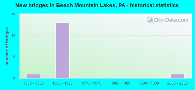
- New bridges - historical statistics
- 11950-1959
- 131960-1969
- 12000-2009


- Bridge Condition - Deck
- 20.0%Satisfactory
- 40.0%Fair
- 40.0%Poor

- Bridge Condition - Superstructure
- 20.0%Good
- 40.0%Satisfactory
- 20.0%Fair
- 20.0%Poor

- Bridge Condition - Substructure
- 20.0%Satisfactory
- 80.0%Fair

- Bridge Condition - Channel
- 60.0%Good
- 20.0%Satisfactory
- 20.0%Fair

- Bridge Condition - Culverts
- 50.0%Good
- 50.0%Satisfactory
Find on map >> Show street view
Structure Number: 23666, Location: BUTLER TWP OVER PA 309 (Lat: 41.053381, Lng: -75.959792), Route carried "on" structure: Interstate 80, Year Built: 1966, Year Reconstructed: 1989, Status: Open, Structure Length: 4.33m (14.21ft), Average Daily Traffic: 12,168 (year 2021), Truck Traffic: 40%, Average Future Daily Traffic: 12,496 (year 2032), Design Load: HS 20+Mod, Features Intersected: PA 309
Minimum Vertical Clearance: 30+ m (98+ ft), Kilometerpoint: 24.505, Lanes on structure: 2, Lanes under structure: 4, Base Highway Network: Yes, Owner: State Highway Agency, Approaching Roadway Width: 11.9m (39.0ft), Skew: 10 degrees, Material/Design: Prestressed concrete, Design/Construction: Box Beam or Girders - Single/Spread, Number Of Spans In Main Unit: 3, Length of Maximum Span: 20.7m (67.9ft), Curb or Sidewalk Widths: Left: 0.2m (0.7ft), Right: 0.2m (0.7ft), Curb-To-Curb Width: 12.4m (40.7ft), Out-to-Out Width: 13.9m (45.6ft)
Condition: Deck: Poor, Superstructure: Fair, Substructure: Fair, Operating Rating: 44.5 metric tons, Method Used To Determine Operating Rating: Load Factor (LF), Inventory Rating: 25.4 metric tons, Method Used To Determine Inventory Rating: Load Factor (LF), Structural Evaluation: Somewhat better than minimum adequacy, Deck Geometry: Better than present minimum criteria, Underclear: Meets minimum limits, Approach Roadway Alignment: Equal to present desirable criteria, Length Of Structure Improvement: 5.21m (17.09ft), Designated Inspection Frequency: Every 24 months, Inspection Date: September 2021, Deck Structure Type: Concrete Cast-file-Place, Wearing Surface/Protective System: Wearing Surface: Latex Concrete
Find on map >> Show street view
Structure Number: 23669, Location: BUTLER TWP 1.6 M E TR 309 (Lat: 41.058839, Lng: -75.931167), Route carried "on" structure: Interstate 80, Year Built: 1966, Year Reconstructed: 1989, Status: Open, Structure Length: 5.73m (18.80ft), Average Daily Traffic: 12,168 (year 2021), Truck Traffic: 40%, Average Future Daily Traffic: 12,496 (year 2032), Design Load: HS 20+Mod, Features Intersected: HONEY HOLE & NESCOPECK
Minimum Vertical Clearance: 30+ m (98+ ft), Kilometerpoint: 26.913, Lanes on structure: 2, Lanes under structure: 2, Base Highway Network: Yes, Owner: State Highway Agency, Approaching Roadway Width: 11.6m (38.1ft), Skew: 11 degrees, Material/Design: Prestressed concrete, Design/Construction: Box Beam or Girders - Single/Spread, Number Of Spans In Main Unit: 3, Length of Maximum Span: 21.9m (71.9ft), Curb or Sidewalk Widths: Left: 0.2m (0.7ft), Right: 0.2m (0.7ft), Curb-To-Curb Width: 10.0m (32.8ft), Out-to-Out Width: 11.4m (37.4ft)
Condition: Deck: Fair, Superstructure: Satisfactory, Substructure: Fair, Channel: Good, Operating Rating: 67.1 metric tons, Method Used To Determine Operating Rating: Load Factor (LF), Inventory Rating: 29.9 metric tons, Method Used To Determine Inventory Rating: Load Factor (LF), Structural Evaluation: Somewhat better than minimum adequacy, Deck Geometry: High priority of replacement, Underclear: Meets minimum limits, Waterway Adequacy: Superior to present desirable criteria, Approach Roadway Alignment: Equal to present desirable criteria, Length Of Structure Improvement: 5.70m (18.70ft), Designated Inspection Frequency: Every 24 months, Inspection Date: September 2021, Bridge Improvement Cost: $59,000, Roadway Improvement Cost: $175,000, Total Project Cost: $801,000, Deck Structure Type: Concrete Cast-file-Place, Wearing Surface/Protective System: Wearing Surface: Latex Concrete
Find on map >> Show street view
Structure Number: 2367, Location: BUTLER TWP 1.6 M E TR 309 (Lat: 41.059353, Lng: -75.930956), Route carried "on" structure: Interstate 80, Year Built: 1966, Year Reconstructed: 1989, Status: Open, Structure Length: 5.73m (18.80ft), Average Daily Traffic: 12,150 (year 2021), Truck Traffic: 41%, Average Future Daily Traffic: 12,854 (year 2032), Design Load: HS 20+Mod, Features Intersected: HONEY HOLE RD, NESCOPECK
Minimum Vertical Clearance: 30+ m (98+ ft), Kilometerpoint: 26.918, Lanes on structure: 2, Lanes under structure: 2, Base Highway Network: Yes, Owner: State Highway Agency, Approaching Roadway Width: 11.6m (38.1ft), Skew: 11 degrees, Material/Design: Prestressed concrete, Design/Construction: Box Beam or Girders - Single/Spread, Number Of Spans In Main Unit: 3, Length of Maximum Span: 21.6m (70.9ft), Curb or Sidewalk Widths: Left: 0.2m (0.7ft), Right: 0.2m (0.7ft), Curb-To-Curb Width: 10.0m (32.8ft), Out-to-Out Width: 11.4m (37.4ft)
Condition: Deck: Fair, Superstructure: Good, Substructure: Fair, Channel: Good, Operating Rating: 67.1 metric tons, Method Used To Determine Operating Rating: Load Factor (LF), Inventory Rating: 29.0 metric tons, Method Used To Determine Inventory Rating: Load Factor (LF), Structural Evaluation: Somewhat better than minimum adequacy, Deck Geometry: High priority of replacement, Underclear: Meets minimum limits, Waterway Adequacy: Superior to present desirable criteria, Approach Roadway Alignment: Equal to present desirable criteria, Length Of Structure Improvement: 5.70m (18.70ft), Designated Inspection Frequency: Every 24 months, Inspection Date: September 2021, Bridge Improvement Cost: $59,000, Roadway Improvement Cost: $175,000, Total Project Cost: $801,000, Deck Structure Type: Concrete Cast-file-Place, Wearing Surface/Protective System: Wearing Surface: Latex Concrete
Find on map >> Show street view
Structure Number: 23671, Location: DENNISON TWP 3.4M E TR309 (Lat: 41.058722, Lng: -75.897683), Route carried "on" structure: Interstate 80, Year Built: 1966, Status: Open, Structure Length: 0.76m (2.49ft), Average Daily Traffic: 12,168 (year 2021), Truck Traffic: 40%, Average Future Daily Traffic: 12,496 (year 2032), Design Load: HS 20+Mod, Features Intersected: OLEY CREEK
Minimum Vertical Clearance: 30+ m (98+ ft), Kilometerpoint: 29.208, Lanes on structure: 2, Base Highway Network: Yes, Owner: State Highway Agency, Approaching Roadway Width: 11.6m (38.1ft), Skew: 23 degrees, Material/Design: Concrete, Design/Construction: Culvert, Number Of Spans In Main Unit: 1, Length of Maximum Span: 7.6m (24.9ft)
Condition: Channel: Fair, Culverts: Satisfactory, Operating Rating: 49.0 metric tons, Method Used To Determine Operating Rating: Field evaluation and documented engineering judgment, Inventory Rating: 32.7 metric tons, Method Used To Determine Inventory Rating: Field evaluation and documented engineering judgment, Structural Evaluation: Equal to present minimum criteria, Waterway Adequacy: Superior to present desirable criteria, Approach Roadway Alignment: Equal to present desirable criteria, Length Of Structure Improvement: 1.50m (4.92ft), Designated Inspection Frequency: Every 48 months, Inspection Date: September 2019
Find on map >> Show street view
Structure Number: 23851, Location: BUTLER TWP .2 M S SR 3040 (Lat: 41.037244, Lng: -75.953239), Route carried "on" structure: State highway 309, Year Built: 1956, Status: Open, Structure Length: 3.54m (11.61ft), Average Daily Traffic: 12,113 (year 2021), Truck Traffic: 5%, Average Future Daily Traffic: 14,322 (year 2032), Design Load: HS 20, Features Intersected: NESCOPECK CREEK
Minimum Vertical Clearance: 30+ m (98+ ft), Kilometerpoint: 15.393, Lanes on structure: 2, Owner: State Highway Agency, Approaching Roadway Width: 17.7m (58.1ft), Skew: 3 degrees, Material/Design: Steel, Design/Construction: Stringer/Multi-beam, Number Of Spans In Main Unit: 2, Length of Maximum Span: 17.1m (56.1ft), Curb or Sidewalk Widths: Left: 0.1m (0.3ft), Right: 0.1m (0.3ft), Curb-To-Curb Width: 17.7m (58.1ft), Out-to-Out Width: 18.7m (61.4ft)
Condition: Deck: Poor, Superstructure: Poor, Substructure: Fair, Channel: Satisfactory, Operating Rating: 58.1 metric tons, Method Used To Determine Operating Rating: Load Factor (LF), Inventory Rating: 34.5 metric tons, Method Used To Determine Inventory Rating: Load Factor (LF), Structural Evaluation: Meets minimum limits, Deck Geometry: Superior to present desirable criteria, Waterway Adequacy: Equal to present minimum criteria, Approach Roadway Alignment: Equal to present desirable criteria, Length Of Structure Improvement: 3.50m (11.48ft), Designated Inspection Frequency: Every 24 months, Inspection Date: January 2021, Bridge Improvement Cost: $60,000, Roadway Improvement Cost: $178,000, Total Project Cost: $813,000, Deck Structure Type: Concrete Cast-file-Place, Wearing Surface/Protective System: Wearing Surface: Bituminous
Find on map >> Show street view
Structure Number: 24235, Location: BUTLER TWP OVER I-80 (Lat: 41.051419, Lng: -75.969989), Route carried "on" structure: State highway , Year Built: 1965, Year Reconstructed: 1988, Status: Open, Structure Length: 6.40m (21.00ft), Average Daily Traffic: 2,250 (year 2021), Truck Traffic: 4%, Average Future Daily Traffic: 1,488 (year 2033), Design Load: HS 20+Mod, Features Intersected: SR 0080 I-80 EB & WB, Facility Carried by Structure: SR3021 TURNPIKE RD
Minimum Vertical Clearance: 30+ m (98+ ft), Kilometerpoint: 5.325, Lanes on structure: 2, Lanes under structure: 4, Owner: State Highway Agency, Approaching Roadway Width: 5.8m (19.0ft), Skew: 1 degrees, Material/Design: Prestressed concrete, Design/Construction: Box Beam or Girders - Multiple, Number Of Spans In Main Unit: 4, Length of Maximum Span: 20.4m (66.9ft), Curb or Sidewalk Widths: Left: 0.2m (0.7ft), Right: 0.2m (0.7ft), Curb-To-Curb Width: 8.7m (28.5ft), Out-to-Out Width: 10.2m (33.5ft)
Condition: Deck: Satisfactory, Superstructure: Satisfactory, Substructure: Satisfactory, Operating Rating: 57.2 metric tons, Method Used To Determine Operating Rating: Load Factor (LF), Inventory Rating: 34.5 metric tons, Method Used To Determine Inventory Rating: Load Factor (LF), Structural Evaluation: Equal to present minimum criteria, Deck Geometry: Meets minimum limits, Underclear: High priority of corrective action, Approach Roadway Alignment: Better than present minimum criteria, Length Of Structure Improvement: 6.40m (21.00ft), Designated Inspection Frequency: Every 24 months, Inspection Date: January 2021, Bridge Improvement Cost: $24,000, Roadway Improvement Cost: $100,000, Total Project Cost: $329,000, Deck Structure Type: Concrete Cast-file-Place, Wearing Surface/Protective System: Wearing Surface: Latex Concrete
Find on map >> Show street view
Structure Number: 57606, Location: 3/4 MI OFF OF RT 309 (Lat: 41.044325, Lng: -75.965058), Route carried "on" structure: City street , Year Built: 2000, Status: Open, Structure Length: 0.73m (2.40ft), Average Daily Traffic: 150 (year 2020), Average Future Daily Traffic: 300 (year 2040), Features Intersected: TRIBUTARY TO NESCOPECK C, Facility Carried by Structure: CORPORATE DR
Minimum Vertical Clearance: 30+ m (98+ ft), Kilometerpoint: 0.000, Lanes on structure: 2, Owner: Town or Township Highway Agency, Approaching Roadway Width: 9.8m (32.2ft), Skew: 9 degrees, Material/Design: Concrete, Design/Construction: Culvert, Number Of Spans In Main Unit: 1, Length of Maximum Span: 0.3m (1.0ft), Curb-To-Curb Width: 9.8m (32.2ft), Out-to-Out Width: 24.5m (80.4ft)
Condition: Channel: Good, Culverts: Good, Operating Rating: 86.2 metric tons, Method Used To Determine Operating Rating: Field evaluation and documented engineering judgment, Inventory Rating: 51.7 metric tons, Method Used To Determine Inventory Rating: Field evaluation and documented engineering judgment, Structural Evaluation: Better than present minimum criteria, Deck Geometry: Better than present minimum criteria, Waterway Adequacy: Better than present minimum criteria, Approach Roadway Alignment: Equal to present desirable criteria, Designated Inspection Frequency: Every 24 months, Inspection Date: October 2020
Find on map >> Show street view
Structure Number: 23666, Location: BUTLER TWP OVER PA 309 (Lat: 41.053381, Lng: -75.959792), Route carried "under" structure: State highway 309, Year Built: 1966, Structure Length: 0. m, Average Daily Traffic: 5,689 (year 2020), Truck Traffic: 11%, Features Intersected: PA 309, Facility Carried by Structure: I-80 EB
Minimum Vertical Clearance: 4.88m (16.01ft), Kilometerpoint: 17.086, Lanes on structure: 2, Lanes under structure: 2, Material/Design: Prestressed concrete, Design/Construction: Box Beam or Girders - Single/Spread, Length of Maximum Span: 20.7m (67.9ft)
Find on map >> Show street view
Structure Number: 23666, Location: BUTLER TWP OVER PA 309 (Lat: 41.053381, Lng: -75.959792), Route carried "under" structure: State highway 309, Year Built: 1966, Structure Length: 0. m, Average Daily Traffic: 5,689 (year 2020), Truck Traffic: 11%, Features Intersected: PA 309, Facility Carried by Structure: I-80 EB
Minimum Vertical Clearance: 4.85m (15.91ft), Kilometerpoint: 17.107, Lanes on structure: 2, Lanes under structure: 2, Material/Design: Prestressed concrete, Design/Construction: Box Beam or Girders - Single/Spread, Length of Maximum Span: 20.7m (67.9ft)
Find on map >> Show street view
Structure Number: 23667, Location: BUTLER TWP OVER PA 309 (Lat: 41.053614, Lng: -75.959897), Route carried "under" structure: State highway 309, Year Built: 1966, Structure Length: 0. m, Average Daily Traffic: 5,689 (year 2020), Truck Traffic: 11%, Features Intersected: SR 0309, Facility Carried by Structure: SR 0080 I-80 WB
Minimum Vertical Clearance: 4.39m (14.40ft), Kilometerpoint: 17.086, Lanes on structure: 2, Lanes under structure: 2, Material/Design: Prestressed concrete, Design/Construction: Box Beam or Girders - Single/Spread, Length of Maximum Span: 20.7m (67.9ft)
Find on map >> Show street view
Structure Number: 23667, Location: BUTLER TWP OVER PA 309 (Lat: 41.053614, Lng: -75.959897), Route carried "under" structure: State highway 309, Year Built: 1966, Structure Length: 0. m, Average Daily Traffic: 5,689 (year 2020), Truck Traffic: 11%, Features Intersected: SR 0309, Facility Carried by Structure: SR 0080 I-80 WB
Minimum Vertical Clearance: 4.37m (14.34ft), Kilometerpoint: 17.107, Lanes on structure: 2, Lanes under structure: 2, Material/Design: Prestressed concrete, Design/Construction: Box Beam or Girders - Single/Spread, Length of Maximum Span: 20.7m (67.9ft)
Find on map >> Show street view
Structure Number: 23669, Location: BUTLER TWP 1.6 M E TR 309 (Lat: 41.058839, Lng: -75.931167), Route carried "under" structure: County highway , Year Built: 1966, Structure Length: 0. m, Average Daily Traffic: 200 (year 1992), Truck Traffic: 1%, Features Intersected: HONEY HOLE & NESCOPECK, Facility Carried by Structure: I-80 EB
Minimum Vertical Clearance: 4.54m (14.90ft), Kilometerpoint: 0.000, Lanes on structure: 2, Lanes under structure: 2, Material/Design: Prestressed concrete, Design/Construction: Box Beam or Girders - Single/Spread, Length of Maximum Span: 21.9m (71.9ft)
Find on map >> Show street view
Structure Number: 2367, Location: BUTLER TWP 1.6 M E TR 309 (Lat: 41.059353, Lng: -75.930956), Route carried "under" structure: County highway , Year Built: 1966, Structure Length: 0. m, Average Daily Traffic: 200 (year 1992), Truck Traffic: 1%, Features Intersected: HONEY HOLE RD, NESCOPECK, Facility Carried by Structure: I-80 WB
Minimum Vertical Clearance: 4.60m (15.09ft), Kilometerpoint: 0.000, Lanes on structure: 2, Lanes under structure: 2, Material/Design: Prestressed concrete, Design/Construction: Box Beam or Girders - Single/Spread, Length of Maximum Span: 21.6m (70.9ft)
Find on map >> Show street view
Structure Number: 24235, Location: BUTLER TWP OVER I-80 (Lat: 41.051419, Lng: -75.969989), Route carried "under" structure: Interstate 80, Year Built: 1965, Structure Length: 0. m, Average Daily Traffic: 11,427 (year 2021), Truck Traffic: 47%, Features Intersected: SR 0080 I-80 EB & WB, Facility Carried by Structure: SR3021 TURNPIKE RD
Minimum Vertical Clearance: 5.41m (17.75ft), Kilometerpoint: 23.701, Lanes on structure: 2, Lanes under structure: 2, Material/Design: Prestressed concrete, Design/Construction: Box Beam or Girders - Multiple, Length of Maximum Span: 20.4m (66.9ft)
Find on map >> Show street view
Structure Number: 24235, Location: BUTLER TWP OVER I-80 (Lat: 41.051419, Lng: -75.969989), Route carried "under" structure: Interstate 80, Year Built: 1965, Structure Length: 0. m, Average Daily Traffic: 11,230 (year 2021), Truck Traffic: 49%, Features Intersected: SR 0080 I-80 EB & WB, Facility Carried by Structure: SR3021 TURNPIKE RD
Minimum Vertical Clearance: 5.28m (17.32ft), Kilometerpoint: 23.683, Lanes on structure: 2, Lanes under structure: 2, Material/Design: Prestressed concrete, Design/Construction: Box Beam or Girders - Multiple, Length of Maximum Span: 20.4m (66.9ft)