Bridge Statistics for Bel-Ridge, Missouri (MO)
Condition, Traffic, Stress, Structural Evaluation, Project Costs
- National Bridge Inventory (NBI) Statistics
- 14Number of bridges
- 89ft / 26.9mTotal length
- 336,610Total average daily traffic
- 36,779Total average daily truck traffic
- National Bridge Inventory (NBI) Registered Bridges for Bel-Ridge
- No street view available for this location
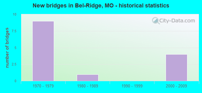
- New bridges - historical statistics
- 91970-1979
- 11980-1989
- 42000-2009


- Bridge Condition - Deck
- 20.0%Good
- 60.0%Satisfactory
- 20.0%Fair

- Bridge Condition - Superstructure
- 40.0%Good
- 40.0%Satisfactory
- 20.0%Fair

- Bridge Condition - Substructure
- 60.0%Good
- 40.0%Satisfactory

- Bridge Condition - Channel
- 33.3%Satisfactory
- 33.3%Fair
- 33.3%Poor

- Bridge Condition - Culverts
- 33.3%Satisfactory
- 66.7%Fair
Find on map >> Show street view
Structure Number: 12026, Location: S 24 T 46 N R 6 E (Lat: 38.710975, Lng: -90.285753), Route carried "on" structure: State highway U, Year Built: 2001, Status: Open, Structure Length: 5.82m (19.09ft), Average Daily Traffic: 22,297 (year 2021), Truck Traffic: 6%, Average Future Daily Traffic: 31,216 (year 2041), Design Load: HS 25 or greater, Features Intersected: IS 70
Minimum Vertical Clearance: 30+ m (98+ ft), Kilometerpoint: 1.833, Lanes on structure: 6, Lanes under structure: 8, Base Highway Network: Yes, Owner: State Highway Agency, Approaching Roadway Width: 21.3m (69.9ft), Material/Design: Steel continuous, Design/Construction: Stringer/Multi-beam, Number Of Spans In Main Unit: 2, Length of Maximum Span: 29.1m (95.5ft), Curb-To-Curb Width: 29.3m (96.1ft), Out-to-Out Width: 30.1m (98.8ft)
Condition: Deck: Satisfactory, Superstructure: Good, Substructure: Good, Operating Rating: 72.0 metric tons, Method Used To Determine Operating Rating: Load Factor (LF), Inventory Rating: 43.2 metric tons, Method Used To Determine Inventory Rating: Load Factor (LF), Structural Evaluation: Better than present minimum criteria, Deck Geometry: Superior to present desirable criteria, Underclear: Meets minimum limits, Approach Roadway Alignment: Equal to present desirable criteria, Designated Inspection Frequency: Every 24 months, Inspection Date: September 2020, Deck Structure Type: Concrete Cast-file-Place, Wearing Surface/Protective System: Wearing Surface: Epoxy Overlay, Deck Protection: Epoxy Coated Reinforcing
Find on map >> Show street view
Structure Number: 2578, Location: S 48 T 46 N R 6 E (Lat: 38.719972, Lng: -90.332206), Route carried "on" structure: Interstate 170, Year Built: 1979, Status: Open, Structure Length: 7.04m (23.10ft), Average Daily Traffic: 51,510 (year 2021), Truck Traffic: 4%, Average Future Daily Traffic: 64,388 (year 2041), Design Load: HS 20, Features Intersected: MO 115
Minimum Vertical Clearance: 30+ m (98+ ft), Kilometerpoint: 6.536, Lanes on structure: 4, Lanes under structure: 6, Base Highway Network: Yes, Owner: State Highway Agency, Approaching Roadway Width: 21.0m (68.9ft), Skew: 24 degrees, Material/Design: Steel continuous, Design/Construction: Stringer/Multi-beam, Number Of Spans In Main Unit: 4, Length of Maximum Span: 23.5m (77.1ft), Curb or Sidewalk Widths: Left: 0.2m (0.7ft), Right: 0.2m (0.7ft), Curb-To-Curb Width: 20.6m (67.6ft), Out-to-Out Width: 21.3m (69.9ft)
Condition: Deck: Satisfactory, Superstructure: Fair, Substructure: Satisfactory, Operating Rating: 55.8 metric tons, Method Used To Determine Operating Rating: Load Factor (LF), Inventory Rating: 33.3 metric tons, Method Used To Determine Inventory Rating: Load Factor (LF), Structural Evaluation: Somewhat better than minimum adequacy, Deck Geometry: Equal to present minimum criteria, Underclear: Equal to present minimum criteria, Approach Roadway Alignment: Equal to present desirable criteria, Designated Inspection Frequency: Every 24 months, Inspection Date: September 2020, Deck Structure Type: Concrete Cast-file-Place, Wearing Surface/Protective System: Wearing Surface: Epoxy Overlay, Deck Protection: Epoxy Coated Reinforcing
Find on map >> Show street view
Structure Number: 2579, Location: S 48 T 46 N R 6 E (Lat: 38.719753, Lng: -90.331986), Route carried "on" structure: Interstate 170, Year Built: 1979, Status: Open, Structure Length: 7.04m (23.10ft), Average Daily Traffic: 53,786 (year 2021), Truck Traffic: 6%, Average Future Daily Traffic: 67,233 (year 2041), Design Load: HS 20, Features Intersected: MO 115
Minimum Vertical Clearance: 30+ m (98+ ft), Kilometerpoint: 11.293, Lanes on structure: 4, Lanes under structure: 6, Base Highway Network: Yes, Owner: State Highway Agency, Approaching Roadway Width: 21.0m (68.9ft), Skew: 24 degrees, Material/Design: Steel continuous, Design/Construction: Stringer/Multi-beam, Number Of Spans In Main Unit: 4, Length of Maximum Span: 23.5m (77.1ft), Curb or Sidewalk Widths: Left: 0.2m (0.7ft), Right: 0.2m (0.7ft), Curb-To-Curb Width: 20.6m (67.6ft), Out-to-Out Width: 21.3m (69.9ft)
Condition: Deck: Satisfactory, Superstructure: Satisfactory, Substructure: Satisfactory, Operating Rating: 55.8 metric tons, Method Used To Determine Operating Rating: Load Factor (LF), Inventory Rating: 33.3 metric tons, Method Used To Determine Inventory Rating: Load Factor (LF), Structural Evaluation: Equal to present minimum criteria, Deck Geometry: Equal to present minimum criteria, Underclear: Equal to present minimum criteria, Approach Roadway Alignment: Equal to present desirable criteria, Designated Inspection Frequency: Every 24 months, Inspection Date: September 2020, Deck Structure Type: Concrete Cast-file-Place, Wearing Surface/Protective System: Wearing Surface: Epoxy Overlay, Deck Protection: Epoxy Coated Reinforcing
Find on map >> Show street view
Structure Number: 258, Location: S 48 T 46 N R 6 E (Lat: 38.719019, Lng: -90.331231), Route carried "on" structure: State highway 115, Year Built: 1979, Status: Open, Structure Length: 0.94m (3.08ft), Average Daily Traffic: 9,496 (year 2021), Truck Traffic: 3%, Average Future Daily Traffic: 13,294 (year 2041), Design Load: HS 20, Features Intersected: MALINE CR
Minimum Vertical Clearance: 30+ m (98+ ft), Kilometerpoint: 2.380, Lanes on structure: 6, Base Highway Network: Yes, Owner: State Highway Agency, Approaching Roadway Width: 31.7m (104.0ft), Skew: 22 degrees, Material/Design: Concrete continuous, Design/Construction: Culvert, Number Of Spans In Main Unit: 3, Length of Maximum Span: 2.7m (8.9ft)
Condition: Channel: Fair, Culverts: Fair, Operating Rating: 87.3 metric tons, Method Used To Determine Operating Rating: Field evaluation and documented engineering judgment, Inventory Rating: 52.2 metric tons, Method Used To Determine Inventory Rating: Field evaluation and documented engineering judgment, Structural Evaluation: Somewhat better than minimum adequacy, Waterway Adequacy: Equal to present desirable criteria, Approach Roadway Alignment: Equal to present desirable criteria, Designated Inspection Frequency: Every 24 months, Inspection Date: November 2021
Find on map >> Show street view
Structure Number: 2586, Location: S 48 T 46 N R 6 E (Lat: 38.716706, Lng: -90.331864), Route carried "on" structure: Ramp State highway , Year Built: 1979, Status: Open, Structure Length: 1.01m (3.31ft), Average Daily Traffic: 2,794 (year 2021), Truck Traffic: 18%, Average Future Daily Traffic: 3,493 (year 2041), Design Load: HS 20, Features Intersected: MALINE CR, Facility Carried by Structure: RP MO115N TO IS170
Minimum Vertical Clearance: 30+ m (98+ ft), Kilometerpoint: 0.341, Lanes on structure: 1, Base Highway Network: Yes, Owner: State Highway Agency, Approaching Roadway Width: 11.0m (36.1ft), Skew: 2 degrees, Material/Design: Concrete continuous, Design/Construction: Culvert, Number Of Spans In Main Unit: 3, Length of Maximum Span: 2.7m (8.9ft)
Condition: Channel: Satisfactory, Culverts: Satisfactory, Operating Rating: 87.3 metric tons, Method Used To Determine Operating Rating: Field evaluation and documented engineering judgment, Inventory Rating: 52.2 metric tons, Method Used To Determine Inventory Rating: Field evaluation and documented engineering judgment, Structural Evaluation: Equal to present minimum criteria, Waterway Adequacy: Equal to present desirable criteria, Approach Roadway Alignment: Equal to present desirable criteria, Designated Inspection Frequency: Every 24 months, Inspection Date: November 2021
Find on map >> Show street view
Structure Number: 30141, Location: S 23 T 46 N R 6 E (Lat: 38.707000, Lng: -90.305369), Route carried "on" structure: State highway 115, Year Built: 2004, Status: Open, Structure Length: 2.82m (9.25ft), Average Daily Traffic: 6,111 (year 2021), Truck Traffic: 10%, Average Future Daily Traffic: 8,555 (year 2041), Design Load: HS 20+Mod, Features Intersected: METROLINK WB, METROLINK
Minimum Vertical Clearance: 30+ m (98+ ft), Kilometerpoint: 5.164, Lanes on structure: 3, Base Highway Network: Yes, Owner: State Highway Agency, Approaching Roadway Width: 20.7m (67.9ft), Skew: 1 degrees, Material/Design: Prestressed concrete, Design/Construction: Box Beam or Girders - Multiple, Number Of Spans In Main Unit: 1, Length of Maximum Span: 20.9m (68.6ft), Curb or Sidewalk Widths: Left: 4.3m (14.1ft), Right: 4.3m (14.1ft), Curb-To-Curb Width: 20.7m (67.9ft), Out-to-Out Width: 25.3m (83.0ft)
Condition: Deck: Good, Superstructure: Good, Substructure: Good, Operating Rating: 72.9 metric tons, Method Used To Determine Operating Rating: Load Factor (LF), Inventory Rating: 44.1 metric tons, Method Used To Determine Inventory Rating: Load Factor (LF), Structural Evaluation: Better than present minimum criteria, Deck Geometry: Superior to present desirable criteria, Underclear: Meets minimum limits, Approach Roadway Alignment: Equal to present desirable criteria, Designated Inspection Frequency: Every 24 months, Inspection Date: September 2020, Deck Structure Type: Concrete Cast-file-Place, Wearing Surface/Protective System: Wearing Surface: Epoxy Overlay, Deck Protection: Epoxy Coated Reinforcing
Find on map >> Show street view
Structure Number: 3217, Location: S 34 T 46 N R 6 E (Lat: 38.681525, Lng: -90.325144), Route carried "on" structure: State highway D, Year Built: 1983, Status: Open, Structure Length: 1.37m (4.49ft), Average Daily Traffic: 15,815 (year 2021), Truck Traffic: 5%, Average Future Daily Traffic: 22,141 (year 2041), Design Load: HS 20+Mod, Features Intersected: UP RR
Minimum Vertical Clearance: 30+ m (98+ ft), Kilometerpoint: 11.750, Lanes on structure: 5, Base Highway Network: Yes, Owner: State Highway Agency, Approaching Roadway Width: 20.7m (67.9ft), Skew: 3 degrees, Material/Design: Concrete, Design/Construction: Frame, Number Of Spans In Main Unit: 1, Length of Maximum Span: 9.6m (31.5ft), Curb-To-Curb Width: 20.7m (67.9ft), Out-to-Out Width: 21.3m (69.9ft)
Condition: Deck: Fair, Superstructure: Satisfactory, Substructure: Good, Operating Rating: 72.9 metric tons, Method Used To Determine Operating Rating: Load Factor (LF), Inventory Rating: 44.1 metric tons, Method Used To Determine Inventory Rating: Load Factor (LF), Structural Evaluation: Equal to present minimum criteria, Deck Geometry: Somewhat better than minimum adequacy, Underclear: Meets minimum limits, Approach Roadway Alignment: Equal to present desirable criteria, Designated Inspection Frequency: Every 24 months, Inspection Date: September 2020
Find on map >> Show street view
Structure Number: 3307, Location: S 48 T 46 N R 6 E (Lat: 38.715442, Lng: -90.332472), Route carried "on" structure: Ramp State highway , Year Built: 1979, Status: Open, Structure Length: 0.81m (2.66ft), Average Daily Traffic: 4,125 (year 2021), Truck Traffic: 3%, Average Future Daily Traffic: 5,156 (year 2041), Design Load: HS 20, Features Intersected: MALINE CR, Facility Carried by Structure: RP IS170W TO MO115
Minimum Vertical Clearance: 30+ m (98+ ft), Kilometerpoint: 0.098, Lanes on structure: 1, Base Highway Network: Yes, Owner: State Highway Agency, Approaching Roadway Width: 9.1m (29.9ft), Skew: 4 degrees, Material/Design: Concrete continuous, Design/Construction: Culvert, Number Of Spans In Main Unit: 2, Length of Maximum Span: 2.7m (8.9ft)
Condition: Channel: Poor, Culverts: Fair, Operating Rating: 78.3 metric tons, Method Used To Determine Operating Rating: Load Factor (LF), Inventory Rating: 46.8 metric tons, Method Used To Determine Inventory Rating: Load Factor (LF), Structural Evaluation: Somewhat better than minimum adequacy, Waterway Adequacy: Equal to present desirable criteria, Approach Roadway Alignment: Equal to present desirable criteria, Designated Inspection Frequency: Every 24 months, Inspection Date: November 2021
Find on map >> Show street view
Structure Number: 12026, Location: S 24 T 46 N R 6 E (Lat: 38.710975, Lng: -90.285753), Route carried "under" structure: Interstate 70, Year Built: 2001, Structure Length: 0. m, Average Daily Traffic: 85,046 (year 2021), Truck Traffic: 18%, Features Intersected: IS 70, Facility Carried by Structure: RT U S
Minimum Vertical Clearance: 4.88m (16.01ft), Kilometerpoint: 389.135, Lanes on structure: 6, Lanes under structure: 4, Material/Design: Steel continuous, Design/Construction: Stringer/Multi-beam, Length of Maximum Span: 29.1m (95.5ft)
Find on map >> Show street view
Structure Number: 12026, Location: S 24 T 46 N R 6 E (Lat: 38.710975, Lng: -90.285753), Route carried "under" structure: Interstate 70, Year Built: 2001, Structure Length: 0. m, Average Daily Traffic: 65,446 (year 2021), Truck Traffic: 18%, Features Intersected: IS 70, Facility Carried by Structure: RT U S
Minimum Vertical Clearance: 4.90m (16.08ft), Kilometerpoint: 13.395, Lanes on structure: 6, Lanes under structure: 4, Material/Design: Steel continuous, Design/Construction: Stringer/Multi-beam, Length of Maximum Span: 29.1m (95.5ft)
Find on map >> Show street view
Structure Number: 2578, Location: S 48 T 46 N R 6 E (Lat: 38.719972, Lng: -90.332206), Route carried "under" structure: State highway 115, Year Built: 1979, Structure Length: 0. m, Average Daily Traffic: 5,041 (year 2021), Truck Traffic: 4%, Features Intersected: MO 115, Facility Carried by Structure: IS 170 E
Minimum Vertical Clearance: 5.15m (16.90ft), Kilometerpoint: 2.264, Lanes on structure: 4, Lanes under structure: 3, Material/Design: Steel continuous, Design/Construction: Stringer/Multi-beam, Length of Maximum Span: 23.5m (77.1ft)
Find on map >> Show street view
Structure Number: 2578, Location: S 48 T 46 N R 6 E (Lat: 38.719972, Lng: -90.332206), Route carried "under" structure: State highway 115, Year Built: 1979, Structure Length: 0. m, Average Daily Traffic: 5,268 (year 2021), Truck Traffic: 4%, Features Intersected: MO 115, Facility Carried by Structure: IS 170 E
Minimum Vertical Clearance: 5.15m (16.90ft), Kilometerpoint: 14.220, Lanes on structure: 4, Lanes under structure: 3, Material/Design: Steel continuous, Design/Construction: Stringer/Multi-beam, Length of Maximum Span: 23.5m (77.1ft)
Find on map >> Show street view
Structure Number: 2579, Location: S 48 T 46 N R 6 E (Lat: 38.719753, Lng: -90.331986), Route carried "under" structure: State highway 115, Year Built: 1979, Structure Length: 0. m, Average Daily Traffic: 5,041 (year 2021), Truck Traffic: 4%, Features Intersected: MO 115, Facility Carried by Structure: IS 170 W
Minimum Vertical Clearance: 5.13m (16.83ft), Kilometerpoint: 2.295, Lanes on structure: 4, Lanes under structure: 3, Material/Design: Steel continuous, Design/Construction: Stringer/Multi-beam, Length of Maximum Span: 23.5m (77.1ft)
Find on map >> Show street view
Structure Number: 2579, Location: S 48 T 46 N R 6 E (Lat: 38.719753, Lng: -90.331986), Route carried "under" structure: State highway 115, Year Built: 1979, Structure Length: 0. m, Average Daily Traffic: 4,834 (year 2021), Truck Traffic: 3%, Features Intersected: MO 115, Facility Carried by Structure: IS 170 W
Minimum Vertical Clearance: 5.15m (16.90ft), Kilometerpoint: 14.190, Lanes on structure: 4, Lanes under structure: 3, Material/Design: Steel continuous, Design/Construction: Stringer/Multi-beam, Length of Maximum Span: 23.5m (77.1ft)