Bridge Statistics for Belle Haven, Virginia (VA)
Condition, Traffic, Stress, Structural Evaluation, Project Costs
- National Bridge Inventory (NBI) Statistics
- 12Number of bridges
- 279ft / 85.4mTotal length
- $11,265,000Total costs
- 533,878Total average daily traffic
- 2,924Total average daily truck traffic
- National Bridge Inventory (NBI) Registered Bridges for Belle Haven
- No street view available for this location
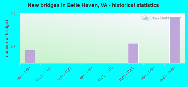
- New bridges - historical statistics
- 21930-1939
- 31980-1989
- 72000-2009


- Bridge Condition - Deck
- 66.7%Good
- 33.3%Satisfactory

- Bridge Condition - Superstructure
- 50.0%Good
- 25.0%Satisfactory
- 25.0%Fair

- Bridge Condition - Substructure
- 50.0%Good
- 25.0%Satisfactory
- 25.0%Poor

- Bridge Condition - Channel
- 28.6%Very good
- 57.1%Satisfactory
- 14.3%Fair

- Bridge Condition - Culverts
- 33.3%Good
- 66.7%Satisfactory
Find on map >> Show street view
Structure Number: 356, Location: 1.16 FR BLHAV/1.48 TO 613 (Lat: 37.557114, Lng: -75.841150), Route carried "on" structure: State highway 178, Year Built: 1933, Status: Posted for load, Structure Length: 2.97m (9.74ft), Average Daily Traffic: 1,794 (year 2020), Truck Traffic: 3%, Average Future Daily Traffic: 1,973 (year 2040), Design Load: HS 20+Mod, Features Intersected: Occohannock Creek, Facility Carried by Structure: Shields Bridge Rd
Minimum Vertical Clearance: 30+ m (98+ ft), Kilometerpoint: 4.232, Lanes on structure: 2, Owner: State Highway Agency, Approaching Roadway Width: 5.8m (19.0ft), Material/Design: Steel, Design/Construction: Stringer/Multi-beam, Number Of Spans In Main Unit: 3, Length of Maximum Span: 9.9m (32.5ft), Curb-To-Curb Width: 7.0m (23.0ft), Out-to-Out Width: 7.6m (24.9ft)
Condition: Deck: Satisfactory, Superstructure: Fair, Substructure: Poor, Channel: Satisfactory, Operating Rating: 33.0 metric tons, Method Used To Determine Operating Rating: Load and Resistance Factor (LRFR), Inventory Rating: 25.5 metric tons, Method Used To Determine Inventory Rating: Load and Resistance Factor (LRFR), Structural Evaluation: Meets minimum limits, Deck Geometry: High priority of corrective action, Waterway Adequacy: Better than present minimum criteria, Approach Roadway Alignment: Equal to present desirable criteria, Length Of Structure Improvement: 4.39m (14.40ft), Designated Inspection Frequency: Every 12 months, Underwater Inspection Frequency: Every 60 months, Inspection Date: June 2021, Underwater Inspection Date: November 2020, Bridge Improvement Cost: $408,000, Roadway Improvement Cost: $41,000, Total Project Cost: $612,000 ( Estimate for 2016), Deck Structure Type: Concrete Cast-file-Place, Wearing Surface/Protective System: Wearing Surface: Epoxy Overlay, Membrane: Epoxy
Find on map >> Show street view
Structure Number: 6934, Location: 00.02FR1/00.15TO629 (Lat: 38.789369, Lng: -77.063236), Route carried "on" structure: County highway 1332, Year Built: 1984, Status: Open, Structure Length: 1.83m (6.00ft), Average Daily Traffic: 12,128 (year 2020), Truck Traffic: 1%, Average Future Daily Traffic: 13,341 (year 2040), Design Load: HS 20, Features Intersected: BRANCH OF HUNTING CREEK, Facility Carried by Structure: HUNTINGTON AVENUE
Minimum Vertical Clearance: 30+ m (98+ ft), Kilometerpoint: 0.097, Lanes on structure: 5, Owner: State Highway Agency, Approaching Roadway Width: 18.6m (61.0ft), Skew: 4 degrees, Material/Design: Concrete, Design/Construction: Culvert, Number Of Spans In Main Unit: 4, Length of Maximum Span: 4.6m (15.1ft)
Condition: Channel: Satisfactory, Culverts: Satisfactory, Operating Rating: 89.8 metric tons, Method Used To Determine Operating Rating: Load Factor (LF), Inventory Rating: 59.0 metric tons, Method Used To Determine Inventory Rating: Load Factor (LF), Structural Evaluation: Equal to present minimum criteria, Waterway Adequacy: Equal to present minimum criteria, Approach Roadway Alignment: Better than present minimum criteria, Length Of Structure Improvement: 3.72m (12.20ft), Designated Inspection Frequency: Every 24 months, Inspection Date: June 2020, Bridge Improvement Cost: $39,000, Roadway Improvement Cost: $79,000, Total Project Cost: $150,000
Find on map >> Show street view
Structure Number: 6938, Location: 00.02FR1503/00.02TO1509 (Lat: 38.775083, Lng: -77.055200), Route carried "on" structure: County highway 1510, Year Built: 1982, Status: Open, Structure Length: 0.67m (2.20ft), Average Daily Traffic: 5,993 (year 2020), Truck Traffic: 3%, Average Future Daily Traffic: 8,390 (year 2040), Design Load: HS 20, Features Intersected: TRIB. POTOMAC RIVER, Facility Carried by Structure: BELLE VIEW ROAD
Minimum Vertical Clearance: 30+ m (98+ ft), Kilometerpoint: 2.574, Lanes on structure: 2, Owner: State Highway Agency, Approaching Roadway Width: 11.0m (36.1ft), Material/Design: Steel, Design/Construction: Culvert, Number Of Spans In Main Unit: 1, Length of Maximum Span: 6.7m (22.0ft), Curb or Sidewalk Widths: Left: 1.5m (4.9ft), Right: 1.5m (4.9ft)
Condition: Channel: Fair, Culverts: Good, Operating Rating: 44.5 metric tons, Method Used To Determine Operating Rating: Load Factor (LF), Inventory Rating: 32.7 metric tons, Method Used To Determine Inventory Rating: Load Factor (LF), Structural Evaluation: Better than present minimum criteria, Waterway Adequacy: Equal to present minimum criteria, Approach Roadway Alignment: Equal to present desirable criteria, Designated Inspection Frequency: Every 24 months, Inspection Date: Febuary 2021
Find on map >> Show street view
Structure Number: 6939, Location: 00.07FR.1501/00.07TO1503 (Lat: 38.776533, Lng: -77.055531), Route carried "on" structure: Alternate County highway 1512, Year Built: 1984, Status: Open, Structure Length: 0.61m (2.00ft), Average Daily Traffic: 209 (year 2016), Average Future Daily Traffic: 211 (year 2040), Design Load: HS 20, Features Intersected: TRIBUTARY OF POTOMAC RIV, Facility Carried by Structure: I STREET
Minimum Vertical Clearance: 30+ m (98+ ft), Kilometerpoint: 0.113, Lanes on structure: 2, Owner: State Highway Agency, Approaching Roadway Width: 9.1m (29.9ft), Material/Design: Steel, Design/Construction: Culvert, Number Of Spans In Main Unit: 3, Length of Maximum Span: 1.6m (5.2ft)
Condition: Channel: Satisfactory, Culverts: Satisfactory, Operating Rating: 44.5 metric tons, Method Used To Determine Operating Rating: Load Factor (LF), Inventory Rating: 32.7 metric tons, Method Used To Determine Inventory Rating: Load Factor (LF), Structural Evaluation: Equal to present minimum criteria, Waterway Adequacy: Better than present minimum criteria, Approach Roadway Alignment: Equal to present desirable criteria, Designated Inspection Frequency: Every 24 months, Inspection Date: August 2020
Find on map >> Show street view
Structure Number: 27084, Location: 00.02FR 1/00.12TO 95 (Lat: 38.792028, Lng: -77.057317), Route carried "on" structure: Ramp Interstate 1, Year Built: 2005, Status: Open, Structure Length: 24.20m (79.40ft), Average Daily Traffic: 12,890 (year 2020), Truck Traffic: 3%, Average Future Daily Traffic: 18,046 (year 2040), Design Load: HS 20, Features Intersected: CAMERON RUN
Minimum Vertical Clearance: 6.27m (20.57ft), Kilometerpoint: 0.000, Lanes on structure: 2, Base Highway Network: Yes, Owner: State Highway Agency, Approaching Roadway Width: 11.6m (38.1ft), Skew: 4 degrees, Material/Design: Prestressed concrete continuous, Design/Construction: Stringer/Multi-beam, Number Of Spans In Main Unit: 11, Length of Maximum Span: 27.4m (89.9ft), Curb or Sidewalk Widths: Left: 0.0m, Right: 3.7m (12.1ft), Curb-To-Curb Width: 11.6m (38.1ft), Out-to-Out Width: 16.7m (54.8ft)
Condition: Deck: Good, Superstructure: Good, Substructure: Good, Channel: Very good, Operating Rating: 89.8 metric tons, Method Used To Determine Operating Rating: Load and Resistance Factor (LRFR), Inventory Rating: 71.9 metric tons, Method Used To Determine Inventory Rating: Load and Resistance Factor (LRFR), Structural Evaluation: Better than present minimum criteria, Deck Geometry: Superior to present desirable criteria, Waterway Adequacy: Equal to present desirable criteria, Approach Roadway Alignment: Equal to present desirable criteria, Designated Inspection Frequency: Every 24 months, Underwater Inspection Frequency: Every 60 months, Inspection Date: April 2021, Underwater Inspection Date: July 2021, Deck Structure Type: Concrete Cast-file-Place, Wearing Surface/Protective System: Wearing Surface: Monolithic Concrete, Membrane: Built-up, Deck Protection: Epoxy Coated Reinforcing
Find on map >> Show street view
Structure Number: 27104, Location: 00.20FR629/00.25TO236 (Lat: 38.791758, Lng: -77.058181), Route carried "on" structure: Interstate 1, Year Built: 2007, Status: Open, Structure Length: 50.93m (167.09ft), Average Daily Traffic: 63,864 (year 2020), Truck Traffic: 3%, Average Future Daily Traffic: 89,410 (year 2040), Design Load: HL 93, Features Intersected: RAMPG;F;I95N&S CAMERONRN
Minimum Vertical Clearance: 30+ m (98+ ft), Kilometerpoint: 308.558, Lanes on structure: 9, Lanes under structure: 80, Base Highway Network: Yes, Owner: State Highway Agency, Approaching Roadway Width: 14.9m (48.9ft), Skew: 22 degrees, Material/Design: Steel, Design/Construction: Stringer/Multi-beam, Number Of Spans In Main Unit: 23, Number Of Approach Spans: 11, Length of Maximum Span: 50.6m (166.0ft), Curb-To-Curb Width: 28.0m (91.9ft), Out-to-Out Width: 45.7m (149.9ft)
Condition: Deck: Good, Superstructure: Good, Substructure: Good, Channel: Very good, Operating Rating: 41.5 metric tons, Method Used To Determine Operating Rating: Load and Resistance Factor (LRFR), Inventory Rating: 32.0 metric tons, Method Used To Determine Inventory Rating: Load and Resistance Factor (LRFR), Structural Evaluation: Better than present minimum criteria, Deck Geometry: High priority of replacement, Underclear: High priority of corrective action, Waterway Adequacy: Equal to present desirable criteria, Approach Roadway Alignment: Equal to present desirable criteria, Length Of Structure Improvement: 0.03m (0.10ft), Designated Inspection Frequency: Every 24 months, Underwater Inspection Frequency: Every 60 months, Inspection Date: May 2020, Underwater Inspection Date: April 2017, Bridge Improvement Cost: $1,000, Roadway Improvement Cost: $1,000, Total Project Cost: $3,000, Deck Structure Type: Concrete Cast-file-Place, Wearing Surface/Protective System: Wearing Surface: Monolithic Concrete, Deck Protection: Epoxy Coated Reinforcing
Find on map >> Show street view
Structure Number: 3300023P, Location: 0.3 MILES SOUTH OF I-95/4 (Lat: 38.789556, Lng: -77.050889), Route carried "on" structure: Federal lands road 3, Year Built: 1932, Year Reconstructed: 1975, Status: Open, Structure Length: 4.21m (13.81ft), Average Daily Traffic: 27,000 (year 2013), Truck Traffic: 1%, Average Future Daily Traffic: 29,700 (year 2033), Design Load: H 15, Features Intersected: HUNTING CREEK, Facility Carried by Structure: GEORGE WASHINGTON
Minimum Vertical Clearance: 30+ m (98+ ft), Kilometerpoint: 0.000, Lanes on structure: 4, Owner: National Park Service, Approaching Roadway Width: 12.2m (40.0ft), Material/Design: Concrete, Design/Construction: Arch - Deck, Number Of Spans In Main Unit: 3, Length of Maximum Span: 13.4m (44.0ft), Curb or Sidewalk Widths: Left: 3.0m (9.8ft), Right: 0.0m, Curb-To-Curb Width: 20.0m (65.6ft), Out-to-Out Width: 21.1m (69.2ft)
Condition: Superstructure: Satisfactory, Substructure: Satisfactory, Channel: Satisfactory, Operating Rating: 46.3 metric tons, Method Used To Determine Operating Rating: Load Factor (LF), Inventory Rating: 27.2 metric tons, Method Used To Determine Inventory Rating: Load Factor (LF), Structural Evaluation: Equal to present minimum criteria, Deck Geometry: Better than present minimum criteria, Waterway Adequacy: Equal to present desirable criteria, Approach Roadway Alignment: Equal to present desirable criteria, Length Of Structure Improvement: 4.66m (15.29ft), Designated Inspection Frequency: Every 24 months, Underwater Inspection Frequency: Every 60 months, Inspection Date: April 2021, Underwater Inspection Date: July 2018, Bridge Improvement Cost: $7,000,000, Roadway Improvement Cost: $700,000, Total Project Cost: $10,500,000
Find on map >> Show street view
Structure Number: 27104, Location: 00.20FR629/00.25TO236 (Lat: 38.791758, Lng: -77.058181), Route carried "under" structure: Interstate 95, Year Built: 2007, Structure Length: 0. m, Average Daily Traffic: 140,000 (year 2007), Features Intersected: RAMPG;F;I95N&S CAMERONRN, Facility Carried by Structure: RTE 1 J DAVIS HWY
Minimum Vertical Clearance: 6.60m (21.65ft), Kilometerpoint: 0.000, Lanes on structure: 9, Lanes under structure: 16, Material/Design: Steel, Design/Construction: Stringer/Multi-beam, Length of Maximum Span: 50.6m (166.0ft)
Find on map >> Show street view
Structure Number: 27104, Location: 00.20FR629/00.25TO236 (Lat: 38.791758, Lng: -77.058181), Route carried "under" structure: Ramp US 1, Year Built: 2007, Structure Length: 0. m, Average Daily Traffic: 20,000 (year 2007), Features Intersected: RAMPG;F;I95N&S CAMERONRN
Minimum Vertical Clearance: 5.26m (17.26ft), Kilometerpoint: 0.000, Lanes on structure: 9, Lanes under structure: 16, Material/Design: Steel, Design/Construction: Stringer/Multi-beam, Length of Maximum Span: 50.6m (166.0ft)
Find on map >> Show street view
Structure Number: 27104, Location: 00.20FR629/00.25TO236 (Lat: 38.791758, Lng: -77.058181), Route carried "under" structure: Interstate 95, Year Built: 2007, Structure Length: 0. m, Average Daily Traffic: 80,000 (year 2007), Features Intersected: RAMPG;F;I95N&S CAMERONRN, Facility Carried by Structure: RTE 1 J DAVIS HWY
Minimum Vertical Clearance: 6.04m (19.82ft), Kilometerpoint: 0.000, Lanes on structure: 9, Lanes under structure: 16, Material/Design: Steel, Design/Construction: Stringer/Multi-beam, Length of Maximum Span: 50.6m (166.0ft)
Find on map >> Show street view
Structure Number: 27104, Location: 00.20FR629/00.25TO236 (Lat: 38.791758, Lng: -77.058181), Route carried "under" structure: Interstate 95, Year Built: 2007, Structure Length: 0. m, Average Daily Traffic: 80,000 (year 2007), Features Intersected: RAMPG;F;I95N&S CAMERONRN, Facility Carried by Structure: RTE 1 J DAVIS HWY
Minimum Vertical Clearance: 6.35m (20.83ft), Kilometerpoint: 0.000, Lanes on structure: 9, Lanes under structure: 16, Material/Design: Steel, Design/Construction: Stringer/Multi-beam, Length of Maximum Span: 50.6m (166.0ft)
Find on map >> Show street view
Structure Number: 27104, Location: 00.20FR629/00.25TO236 (Lat: 38.791758, Lng: -77.058181), Route carried "under" structure: Interstate 95, Year Built: 2007, Structure Length: 0. m, Average Daily Traffic: 90,000 (year 2007), Features Intersected: RAMPG;F;I95N&S CAMERONRN, Facility Carried by Structure: RTE 1 J DAVIS HWY
Minimum Vertical Clearance: 5.31m (17.42ft), Kilometerpoint: 0.000, Lanes on structure: 9, Lanes under structure: 16, Material/Design: Steel, Design/Construction: Stringer/Multi-beam, Length of Maximum Span: 50.6m (166.0ft)