Bridge Statistics for Belle Mead, New Jersey (NJ)
Condition, Traffic, Stress, Structural Evaluation, Project Costs
- National Bridge Inventory (NBI) Statistics
- 17Number of bridges
- 138ft / 42.4mTotal length
- $5,041,000Total costs
- 121,509Total average daily traffic
- 4,212Total average daily truck traffic
- National Bridge Inventory (NBI) Registered Bridges for Belle Mead
- No street view available for this location
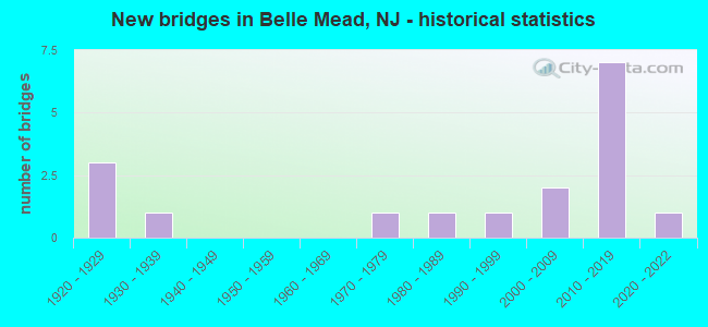
- New bridges - historical statistics
- 31920-1929
- 11930-1939
- 11970-1979
- 11980-1989
- 11990-1999
- 22000-2009
- 72010-2019
- 12020-2022


- Bridge Condition - Deck
- 7.7%Excellent
- 15.4%Very good
- 53.8%Good
- 15.4%Satisfactory
- 7.7%Fair

- Bridge Condition - Superstructure
- 14.3%Excellent
- 28.6%Very good
- 28.6%Good
- 7.1%Satisfactory
- 21.4%Fair

- Bridge Condition - Substructure
- 14.3%Excellent
- 7.1%Very good
- 50.0%Good
- 7.1%Satisfactory
- 21.4%Fair

- Bridge Condition - Channel
- 11.1%Very good
- 44.4%Good
- 33.3%Satisfactory
- 11.1%Fair

- Bridge Condition - Culverts
- 50.0%Good
- 50.0%Poor
Find on map >> Show street view
Structure Number: 1810156, Location: 4.7 MI N OF CO. 518 JCT (Lat: 40.466669, Lng: -74.662781), Route carried "on" structure: US 206, Year Built: 2011, Status: Open, Structure Length: 4.72m (15.49ft), Average Daily Traffic: 25,520 (year 2021), Truck Traffic: 4%, Average Future Daily Traffic: 30,625 (year 2041), Design Load: HL 93, Features Intersected: CSXT
Minimum Vertical Clearance: 30+ m (98+ ft), Kilometerpoint: 101.002, Lanes on structure: 3, Base Highway Network: Yes, Owner: State Highway Agency, Approaching Roadway Width: 17.1m (56.1ft), Skew: 4 degrees, Material/Design: Steel, Design/Construction: Stringer/Multi-beam, Number Of Spans In Main Unit: 1, Length of Maximum Span: 44.8m (147.0ft), Curb or Sidewalk Widths: Left: 1.8m (5.9ft), Right: 1.8m (5.9ft), Curb-To-Curb Width: 17.1m (56.1ft), Out-to-Out Width: 21.3m (69.9ft)
Condition: Deck: Very good, Superstructure: Very good, Substructure: Good, Operating Rating: 45.4 metric tons, Method Used To Determine Operating Rating: Load and Resistance Factor Rating (LRFR) rating reported by rating factor(RF) method using HL-93 loadings, Inventory Rating: 35.0 metric tons, Method Used To Determine Inventory Rating: Load and Resistance Factor Rating (LRFR) rating reported by rating factor(RF) method using HL-93 loadings, Structural Evaluation: Better than present minimum criteria, Deck Geometry: Superior to present desirable criteria, Underclear: Superior to present desirable criteria, Approach Roadway Alignment: Equal to present minimum criteria, Designated Inspection Frequency: Every 24 months, Inspection Date: September 2021, Deck Structure Type: Concrete Cast-file-Place, Wearing Surface/Protective System: Wearing Surface: Monolithic Concrete, Deck Protection: Epoxy Coated Reinforcing
Find on map >> Show street view
Structure Number: 1810158, Location: 2 MI SOUTH OF RT 514 JCT (Lat: 40.474081, Lng: -74.656931), Route carried "on" structure: US 206, Year Built: 1927, Status: Open, Structure Length: 1.04m (3.41ft), Average Daily Traffic: 25,276 (year 2020), Truck Traffic: 4%, Average Future Daily Traffic: 30,331 (year 2040), Design Load: H 20, Features Intersected: PIKE RUN
Minimum Vertical Clearance: 30+ m (98+ ft), Kilometerpoint: 101.968, Lanes on structure: 2, Base Highway Network: Yes, Owner: State Highway Agency, Approaching Roadway Width: 12.2m (40.0ft), Material/Design: Steel, Design/Construction: Stringer/Multi-beam, Number Of Spans In Main Unit: 1, Length of Maximum Span: 9.4m (30.8ft), Curb or Sidewalk Widths: Left: 1.5m (4.9ft), Right: 0.0m, Curb-To-Curb Width: 12.2m (40.0ft), Out-to-Out Width: 14.9m (48.9ft)
Condition: Deck: Satisfactory, Superstructure: Fair, Substructure: Satisfactory, Channel: Satisfactory, Operating Rating: 73.5 metric tons, Method Used To Determine Operating Rating: Load Factor (LF), Inventory Rating: 43.5 metric tons, Method Used To Determine Inventory Rating: Load Factor (LF), Structural Evaluation: Somewhat better than minimum adequacy, Deck Geometry: Somewhat better than minimum adequacy, Waterway Adequacy: Somewhat better than minimum adequacy, Approach Roadway Alignment: Equal to present desirable criteria, Length Of Structure Improvement: 1.04m (3.41ft), Designated Inspection Frequency: Every 24 months, Inspection Date: July 2020, Bridge Improvement Cost: $165,000, Total Project Cost: $266,000 ( Estimate for 2020), Deck Structure Type: Concrete Cast-file-Place, Wearing Surface/Protective System: Wearing Surface: Bituminous
Find on map >> Show street view
Structure Number: 181016, Location: 0.43 MLE SOUTH OF 514 JCT (Lat: 40.496550, Lng: -74.647381), Route carried "on" structure: US 206, Year Built: 1928, Status: Open, Structure Length: 1.46m (4.79ft), Average Daily Traffic: 25,276 (year 2020), Truck Traffic: 4%, Average Future Daily Traffic: 30,331 (year 2040), Features Intersected: BR ROYCES BROOK
Minimum Vertical Clearance: 30+ m (98+ ft), Kilometerpoint: 104.591, Lanes on structure: 2, Base Highway Network: Yes, Owner: State Highway Agency, Approaching Roadway Width: 12.2m (40.0ft), Skew: 1 degrees, Material/Design: Steel, Design/Construction: Stringer/Multi-beam, Number Of Spans In Main Unit: 1, Length of Maximum Span: 13.4m (44.0ft), Curb-To-Curb Width: 12.2m (40.0ft), Out-to-Out Width: 13.5m (44.3ft)
Condition: Deck: Fair, Superstructure: Fair, Substructure: Fair, Channel: Fair, Operating Rating: 51.7 metric tons, Method Used To Determine Operating Rating: Load Factor (LF), Inventory Rating: 30.8 metric tons, Method Used To Determine Inventory Rating: Load Factor (LF), Structural Evaluation: Somewhat better than minimum adequacy, Deck Geometry: Somewhat better than minimum adequacy, Waterway Adequacy: Superior to present desirable criteria, Approach Roadway Alignment: Equal to present desirable criteria, Designated Inspection Frequency: Every 24 months, Inspection Date: July 2020, Deck Structure Type: Concrete Cast-file-Place, Wearing Surface/Protective System: Wearing Surface: Bituminous
Find on map >> Show street view
Structure Number: 1810181, Location: 0.3 MI NO. OF US RT 206 (Lat: 40.478611, Lng: -74.649161), Route carried "on" structure: Bypass US 206, Year Built: 2021, Status: Open, Structure Length: 5.36m (17.59ft), Average Daily Traffic: 5,000 (year 2021), Average Future Daily Traffic: 6,000 (year 2041), Design Load: HL 93, Features Intersected: US 206
Minimum Vertical Clearance: 30.18m (99.02ft), Kilometerpoint: 0.483, Lanes on structure: 2, Owner: State Highway Agency, Approaching Roadway Width: 15.3m (50.2ft), Skew: 11 degrees, Material/Design: Steel, Design/Construction: Stringer/Multi-beam, Number Of Spans In Main Unit: 1, Length of Maximum Span: 53.6m (175.9ft), Curb or Sidewalk Widths: Left: 0.2m (0.7ft), Right: 0.0m, Curb-To-Curb Width: 19.8m (65.0ft), Out-to-Out Width: 20.8m (68.2ft)
Condition: Deck: Excellent, Superstructure: Excellent, Substructure: Excellent, Operating Rating: 52.8 metric tons, Method Used To Determine Operating Rating: Load and Resistance Factor Rating (LRFR) rating reported by rating factor(RF) method using HL-93 loadings, Inventory Rating: 40.5 metric tons, Method Used To Determine Inventory Rating: Load and Resistance Factor Rating (LRFR) rating reported by rating factor(RF) method using HL-93 loadings, Structural Evaluation: Superior to present desirable criteria, Deck Geometry: Superior to present desirable criteria, Underclear: Superior to present desirable criteria, Approach Roadway Alignment: Better than present minimum criteria, Designated Inspection Frequency: Every 24 months, Inspection Date: September 2021, Deck Structure Type: Concrete Cast-file-Place, Wearing Surface/Protective System: Wearing Surface: Latex Concrete, Deck Protection: Epoxy Coated Reinforcing
Find on map >> Show street view
Structure Number: 1810182, Location: 1.2 miles SW OF CR 514 (Lat: 40.486081, Lng: -74.639681), Route carried "on" structure: Bypass US 206, Year Built: 2013, Status: Open, Structure Length: 2.83m (9.28ft), Average Daily Traffic: 1,888 (year 2021), Truck Traffic: 2%, Average Future Daily Traffic: 2,711 (year 2041), Design Load: HL 93, Features Intersected: HOMESTEAD RD.
Minimum Vertical Clearance: 30+ m (98+ ft), Kilometerpoint: 0.740, Lanes on structure: 2, Lanes under structure: 2, Owner: State Highway Agency, Approaching Roadway Width: 15.2m (49.9ft), Skew: 20 degrees, Material/Design: Prestressed concrete, Design/Construction: Stringer/Multi-beam, Number Of Spans In Main Unit: 1, Length of Maximum Span: 27.1m (88.9ft), Curb-To-Curb Width: 19.5m (64.0ft), Out-to-Out Width: 20.6m (67.6ft)
Condition: Deck: Good, Superstructure: Very good, Substructure: Good, Operating Rating: 89.7 metric tons, Method Used To Determine Operating Rating: Load and Resistance Factor Rating (LRFR) rating reported by rating factor(RF) method using HL-93 loadings, Inventory Rating: 71.3 metric tons, Method Used To Determine Inventory Rating: Load and Resistance Factor Rating (LRFR) rating reported by rating factor(RF) method using HL-93 loadings, Structural Evaluation: Better than present minimum criteria, Deck Geometry: Superior to present desirable criteria, Underclear: Equal to present minimum criteria, Approach Roadway Alignment: Equal to present desirable criteria, Designated Inspection Frequency: Every 24 months, Inspection Date: September 2021, Deck Structure Type: Concrete Cast-file-Place, Wearing Surface/Protective System: Wearing Surface: Monolithic Concrete, Deck Protection: Epoxy Coated Reinforcing
Find on map >> Show street view
Structure Number: 1810183, Location: 1 MI. N. OF HILLSBOROUGH (Lat: 40.488731, Lng: -74.638939), Route carried "on" structure: Bypass US 206, Year Built: 2013, Status: Open, Structure Length: 7.71m (25.30ft), Average Daily Traffic: 1,860 (year 2021), Truck Traffic: 4%, Average Future Daily Traffic: 2,232 (year 2041), Design Load: HL 93, Features Intersected: CSX RR
Minimum Vertical Clearance: 30.45m (99.90ft), Kilometerpoint: 1.007, Lanes on structure: 2, Base Highway Network: Yes, Owner: State Highway Agency, Approaching Roadway Width: 15.0m (49.2ft), Skew: 26 degrees, Material/Design: Steel, Design/Construction: Stringer/Multi-beam, Number Of Spans In Main Unit: 1, Length of Maximum Span: 70.1m (230.0ft), Curb-To-Curb Width: 15.0m (49.2ft), Out-to-Out Width: 20.8m (68.2ft)
Condition: Deck: Good, Superstructure: Excellent, Substructure: Excellent, Operating Rating: 52.8 metric tons, Method Used To Determine Operating Rating: Load and Resistance Factor Rating (LRFR) rating reported by rating factor(RF) method using HL-93 loadings, Inventory Rating: 40.8 metric tons, Method Used To Determine Inventory Rating: Load and Resistance Factor Rating (LRFR) rating reported by rating factor(RF) method using HL-93 loadings, Structural Evaluation: Superior to present desirable criteria, Deck Geometry: Superior to present desirable criteria, Underclear: Equal to present desirable criteria, Approach Roadway Alignment: Equal to present desirable criteria, Designated Inspection Frequency: Every 24 months, Inspection Date: July 2021, Deck Structure Type: Concrete Cast-file-Place, Wearing Surface/Protective System: Wearing Surface: Monolithic Concrete, Deck Protection: Epoxy Coated Reinforcing
Find on map >> Show street view
Structure Number: 1810184, Location: 0.46 MILES S.OF JCT CR514 (Lat: 40.494131, Lng: -74.637039), Route carried "on" structure: Bypass US 206, Year Built: 2012, Status: Open, Structure Length: 5.06m (16.60ft), Average Daily Traffic: 167 (year 2021), Truck Traffic: 1%, Average Future Daily Traffic: 200 (year 2041), Design Load: HL 93, Features Intersected: US-206
Minimum Vertical Clearance: 30+ m (98+ ft), Kilometerpoint: 1.674, Lanes on structure: 2, Owner: State Highway Agency, Approaching Roadway Width: 16.2m (53.1ft), Skew: 22 degrees, Material/Design: Steel, Design/Construction: Stringer/Multi-beam, Number Of Spans In Main Unit: 1, Length of Maximum Span: 48.2m (158.1ft), Curb-To-Curb Width: 16.1m (52.8ft), Out-to-Out Width: 21.6m (70.9ft)
Condition: Deck: Good, Superstructure: Very good, Substructure: Very good, Channel: Very good, Operating Rating: 57.0 metric tons, Method Used To Determine Operating Rating: Load and Resistance Factor Rating (LRFR) rating reported by rating factor(RF) method using HL-93 loadings, Inventory Rating: 44.1 metric tons, Method Used To Determine Inventory Rating: Load and Resistance Factor Rating (LRFR) rating reported by rating factor(RF) method using HL-93 loadings, Structural Evaluation: Equal to present desirable criteria, Deck Geometry: Superior to present desirable criteria, Waterway Adequacy: Equal to present desirable criteria, Approach Roadway Alignment: Equal to present desirable criteria, Designated Inspection Frequency: Every 24 months, Inspection Date: September 2021, Deck Structure Type: Concrete Cast-file-Place
Find on map >> Show street view
Structure Number: 1850161, Location: 1.07 MI WEST OF RTE. 206 (Lat: 40.448769, Lng: -74.681989), Route carried "on" structure: County highway 604, Year Built: 1926, Year Reconstructed: 1996, Status: Open, Structure Length: 3.14m (10.30ft), Average Daily Traffic: 1,772 (year 2021), Truck Traffic: 3%, Average Future Daily Traffic: 2,163 (year 2041), Features Intersected: TRENTON LINE (CSXT)
Minimum Vertical Clearance: 30+ m (98+ ft), Kilometerpoint: 0.692, Lanes on structure: 2, Maintenance Responsibility: State Highway Agency, Approaching Roadway Width: 7.6m (24.9ft), Skew: 4 degrees, Material/Design: Steel, Design/Construction: Girder and Floorbeam System, Number Of Spans In Main Unit: 1, Length of Maximum Span: 30.8m (101.0ft), Curb-To-Curb Width: 7.0m (23.0ft), Out-to-Out Width: 8.2m (26.9ft)
Condition: Deck: Good, Superstructure: Fair, Substructure: Fair, Operating Rating: 50.8 metric tons, Method Used To Determine Operating Rating: Load Factor (LF), Inventory Rating: 29.9 metric tons, Method Used To Determine Inventory Rating: Load Factor (LF), Structural Evaluation: Somewhat better than minimum adequacy, Deck Geometry: High priority of corrective action, Underclear: Somewhat better than minimum adequacy, Approach Roadway Alignment: Somewhat better than minimum adequacy, Length Of Structure Improvement: 3.96m (12.99ft), Designated Inspection Frequency: Every 24 months, Critical Feature Inspection Frequency: Every 24 months, Inspection Date: September 2021, Critical Feature Inspection Date: September 2021, Bridge Improvement Cost: $1,442,000, Roadway Improvement Cost: $144,000, Total Project Cost: $2,570,000 ( Estimate for 2021), Deck Structure Type: Concrete Cast-file-Place, Wearing Surface/Protective System: Wearing Surface: Bituminous, Deck Protection: Epoxy Coated Reinforcing
Find on map >> Show street view
Structure Number: 1850163, Location: 0.4 MI E OF RT 206. (Lat: 40.481261, Lng: -74.647361), Route carried "on" structure: City street , Year Built: 2012, Status: Open, Structure Length: 2.26m (7.41ft), Average Daily Traffic: 1,490 (year 2020), Truck Traffic: 3%, Average Future Daily Traffic: 1,820 (year 2040), Design Load: HL 93, Features Intersected: TRENTON LINE (CSXT), Facility Carried by Structure: HILLSBOROUGH RD.
Minimum Vertical Clearance: 30+ m (98+ ft), Kilometerpoint: 0.546, Lanes on structure: 2, Owner: State Highway Agency, Approaching Roadway Width: 8.5m (27.9ft), Skew: 2 degrees, Material/Design: Prestressed concrete, Design/Construction: Box Beam or Girders - Multiple, Number Of Spans In Main Unit: 1, Length of Maximum Span: 21.0m (68.9ft), Curb-To-Curb Width: 8.5m (27.9ft), Out-to-Out Width: 9.3m (30.5ft)
Condition: Deck: Good, Superstructure: Good, Substructure: Good, Operating Rating: 82.0 metric tons, Method Used To Determine Operating Rating: Load and Resistance Factor Rating (LRFR) rating reported by rating factor(RF) method using HL-93 loadings, Inventory Rating: 65.8 metric tons, Method Used To Determine Inventory Rating: Load and Resistance Factor Rating (LRFR) rating reported by rating factor(RF) method using HL-93 loadings, Structural Evaluation: Better than present minimum criteria, Deck Geometry: Somewhat better than minimum adequacy, Underclear: Somewhat better than minimum adequacy, Approach Roadway Alignment: Equal to present minimum criteria, Designated Inspection Frequency: Every 24 months, Inspection Date: October 2020, Deck Structure Type: Concrete Cast-file-Place, Wearing Surface/Protective System: Wearing Surface: Monolithic Concrete, Deck Protection: Epoxy Coated Reinforcing
Find on map >> Show street view
Structure Number: 1850164, Location: 0.5 ML E OF RT 206 (Lat: 40.486611, Lng: -74.641650), Route carried "on" structure: City street , Year Built: 2013, Status: Open, Structure Length: 2.26m (7.41ft), Average Daily Traffic: 760 (year 2020), Truck Traffic: 1%, Average Future Daily Traffic: 920 (year 2040), Design Load: HL 93, Features Intersected: TRENTON LINE(CSXT), Facility Carried by Structure: HOMESTEAD ROAD
Minimum Vertical Clearance: 30+ m (98+ ft), Kilometerpoint: 0.000, Lanes on structure: 2, Owner: State Highway Agency, Approaching Roadway Width: 8.5m (27.9ft), Skew: 2 degrees, Material/Design: Concrete, Design/Construction: Box Beam or Girders - Multiple, Number Of Spans In Main Unit: 1, Length of Maximum Span: 21.0m (68.9ft), Curb-To-Curb Width: 8.5m (27.9ft), Out-to-Out Width: 9.3m (30.5ft)
Condition: Deck: Very good, Superstructure: Very good, Substructure: Good, Operating Rating: 81.6 metric tons, Method Used To Determine Operating Rating: Load and Resistance Factor Rating (LRFR) rating reported by rating factor(RF) method using HL-93 loadings, Inventory Rating: 65.4 metric tons, Method Used To Determine Inventory Rating: Load and Resistance Factor Rating (LRFR) rating reported by rating factor(RF) method using HL-93 loadings, Structural Evaluation: Better than present minimum criteria, Deck Geometry: Somewhat better than minimum adequacy, Underclear: Equal to present minimum criteria, Approach Roadway Alignment: Equal to present desirable criteria, Designated Inspection Frequency: Every 24 months, Inspection Date: October 2020, Deck Structure Type: Concrete Cast-file-Place, Wearing Surface/Protective System: Wearing Surface: Monolithic Concrete, Deck Protection: Epoxy Coated Reinforcing
Find on map >> Show street view
Structure Number: 18D0403, Location: 0.3 MI NORTH OF CR 601 (Lat: 40.472100, Lng: -74.675750), Route carried "on" structure: City street , Year Built: 2008, Status: Open, Structure Length: 0.82m (2.69ft), Average Daily Traffic: 1,133 (year 2021), Truck Traffic: 3%, Average Future Daily Traffic: 1,359 (year 2041), Design Load: HS 25 or greater, Features Intersected: TRIBUTARY TO PIKE RUN, Facility Carried by Structure: PLEASANT VIEW ROAD
Minimum Vertical Clearance: 30+ m (98+ ft), Kilometerpoint: 0.000, Lanes on structure: 2, Owner: County Highway Agency, Approaching Roadway Width: 9.1m (29.9ft), Skew: 2 degrees, Material/Design: Concrete, Design/Construction: Culvert, Number Of Spans In Main Unit: 1, Length of Maximum Span: 8.2m (26.9ft), Curb or Sidewalk Widths: Left: 2.7m (8.9ft), Right: 2.7m (8.9ft), Curb-To-Curb Width: 9.1m (29.9ft), Out-to-Out Width: 15.2m (49.9ft)
Condition: Channel: Satisfactory, Culverts: Good, Operating Rating: 77.8 metric tons, Method Used To Determine Operating Rating: Load and Resistance Factor Rating (LRFR) rating reported by rating factor(RF) method using HL-93 loadings, Inventory Rating: 58.0 metric tons, Method Used To Determine Inventory Rating: Load and Resistance Factor Rating (LRFR) rating reported by rating factor(RF) method using HL-93 loadings, Structural Evaluation: Better than present minimum criteria, Deck Geometry: Somewhat better than minimum adequacy, Waterway Adequacy: Equal to present desirable criteria, Approach Roadway Alignment: Equal to present desirable criteria, Designated Inspection Frequency: Every 24 months, Inspection Date: September 2021
Find on map >> Show street view
Structure Number: 18D0501, Location: 0.4MI S OF AMWELL RD (Lat: 40.493961, Lng: -74.667369), Route carried "on" structure: City street , Year Built: 2003, Status: Open, Structure Length: 0.82m (2.69ft), Average Daily Traffic: 604 (year 2021), Truck Traffic: 1%, Average Future Daily Traffic: 725 (year 2041), Design Load: HS 25 or greater, Features Intersected: ROYCE BROOK, Facility Carried by Structure: PLEASANT VIEW ROAD
Minimum Vertical Clearance: 30+ m (98+ ft), Kilometerpoint: 0.000, Lanes on structure: 2, Owner: County Highway Agency, Approaching Roadway Width: 9.1m (29.9ft), Skew: 2 degrees, Material/Design: Wood or Timber, Design/Construction: Slab, Number Of Spans In Main Unit: 1, Length of Maximum Span: 6.4m (21.0ft), Curb or Sidewalk Widths: Left: 1.8m (5.9ft), Right: 0.0m, Curb-To-Curb Width: 9.1m (29.9ft), Out-to-Out Width: 11.6m (38.1ft)
Condition: Deck: Good, Superstructure: Good, Substructure: Good, Channel: Good, Structural Evaluation: Better than present minimum criteria, Deck Geometry: Equal to present minimum criteria, Waterway Adequacy: Better than present minimum criteria, Approach Roadway Alignment: Equal to present desirable criteria, Designated Inspection Frequency: Every 24 months, Inspection Date: September 2021, Deck Structure Type: Wood or Timber, Wearing Surface/Protective System: Wearing Surface: Bituminous, Membrane: Preformed Fabric
Find on map >> Show street view
Structure Number: 18E0405, Location: 0.7 MI WEST of WILLOW RD (Lat: 40.468081, Lng: -74.648669), Route carried "on" structure: City street , Year Built: 1937, Status: Open, Structure Length: 1.19m (3.90ft), Average Daily Traffic: 1,591 (year 2021), Truck Traffic: 1%, Average Future Daily Traffic: 1,909 (year 2041), Features Intersected: PIKE RUN, Facility Carried by Structure: TOWNSHIP LINE ROAD
Minimum Vertical Clearance: 30+ m (98+ ft), Kilometerpoint: 0.000, Lanes on structure: 2, Owner: County Highway Agency, Approaching Roadway Width: 6.7m (22.0ft), Skew: 4 degrees, Material/Design: Concrete, Design/Construction: Tee Beam, Number Of Spans In Main Unit: 1, Length of Maximum Span: 10.7m (35.1ft), Curb or Sidewalk Widths: Left: 0.2m (0.7ft), Right: 0.2m (0.7ft), Curb-To-Curb Width: 9.3m (30.5ft), Out-to-Out Width: 10.5m (34.4ft)
Condition: Deck: Satisfactory, Superstructure: Satisfactory, Substructure: Fair, Channel: Good, Operating Rating: 52.6 metric tons, Method Used To Determine Operating Rating: Load Factor (LF), Inventory Rating: 30.8 metric tons, Method Used To Determine Inventory Rating: Load Factor (LF), Structural Evaluation: Somewhat better than minimum adequacy, Deck Geometry: Somewhat better than minimum adequacy, Waterway Adequacy: Equal to present minimum criteria, Approach Roadway Alignment: Equal to present desirable criteria, Length Of Structure Improvement: 1.07m (3.51ft), Designated Inspection Frequency: Every 24 months, Inspection Date: September 2021, Bridge Improvement Cost: $86,000, Total Project Cost: $214,000 ( Estimate for 2021), Deck Structure Type: Concrete Cast-file-Place, Wearing Surface/Protective System: Wearing Surface: Bituminous
Find on map >> Show street view
Structure Number: 18E0503, Location: 0.4 MI West OF US 206 (Lat: 40.492381, Lng: -74.655500), Route carried "on" structure: City street , Year Built: 1995, Status: Open, Structure Length: 1.55m (5.09ft), Average Daily Traffic: 3,608 (year 2021), Truck Traffic: 1%, Average Future Daily Traffic: 4,330 (year 2041), Design Load: HS 20, Features Intersected: ROYCE BROOK, Facility Carried by Structure: HOMESTEAD ROAD
Minimum Vertical Clearance: 30+ m (98+ ft), Kilometerpoint: 0.000, Lanes on structure: 2, Owner: County Highway Agency, Approaching Roadway Width: 9.1m (29.9ft), Skew: 3 degrees, Material/Design: Concrete continuous, Design/Construction: Frame, Number Of Spans In Main Unit: 2, Length of Maximum Span: 7.6m (24.9ft), Curb or Sidewalk Widths: Left: 1.6m (5.2ft), Right: 1.6m (5.2ft), Curb-To-Curb Width: 9.1m (29.9ft), Out-to-Out Width: 12.7m (41.7ft)
Condition: Superstructure: Good, Substructure: Good, Channel: Good, Inventory Rating: 84.4 metric tons, Method Used To Determine Inventory Rating: Load Factor (LF), Structural Evaluation: Better than present minimum criteria, Deck Geometry: Meets minimum limits, Waterway Adequacy: Better than present minimum criteria, Approach Roadway Alignment: Equal to present desirable criteria, Designated Inspection Frequency: Every 24 months, Inspection Date: October 2021
Find on map >> Show street view
Structure Number: 18E0504, Location: 0.40 MI WEST OF US 206 (Lat: 40.499119, Lng: -74.650911), Route carried "on" structure: County highway 514, Year Built: 1979, Status: Open, Structure Length: 1.01m (3.31ft), Average Daily Traffic: 15,800 (year 2021), Truck Traffic: 4%, Average Future Daily Traffic: 18,960 (year 2041), Design Load: HS 20, Features Intersected: TRIB OF ROYCE BROOK
Minimum Vertical Clearance: 30+ m (98+ ft), Kilometerpoint: 20.616, Lanes on structure: 4, Owner: County Highway Agency, Approaching Roadway Width: 14.0m (45.9ft), Material/Design: Concrete, Design/Construction: Slab, Number Of Spans In Main Unit: 1, Length of Maximum Span: 9.1m (29.9ft), Curb or Sidewalk Widths: Left: 1.5m (4.9ft), Right: 1.5m (4.9ft), Curb-To-Curb Width: 14.0m (45.9ft), Out-to-Out Width: 17.8m (58.4ft)
Condition: Deck: Good, Superstructure: Good, Substructure: Good, Channel: Good, Operating Rating: 85.3 metric tons, Method Used To Determine Operating Rating: Load Factor (LF), Inventory Rating: 50.8 metric tons, Method Used To Determine Inventory Rating: Load Factor (LF), Structural Evaluation: Better than present minimum criteria, Deck Geometry: High priority of replacement, Waterway Adequacy: Equal to present desirable criteria, Approach Roadway Alignment: Equal to present desirable criteria, Length Of Structure Improvement: 1.01m (3.31ft), Designated Inspection Frequency: Every 24 months, Inspection Date: October 2021, Bridge Improvement Cost: $6,000, Roadway Improvement Cost: $3,000, Total Project Cost: $25,000 ( Estimate for 2021), Deck Structure Type: Concrete Cast-file-Place, Wearing Surface/Protective System: Wearing Surface: Bituminous
Find on map >> Show street view
Structure Number: 18E0507, Location: 0.12 MI West of US 206 (Lat: 40.494689, Lng: -74.650411), Route carried "on" structure: City street , Year Built: 1981, Status: Open, Structure Length: 1.13m (3.71ft), Average Daily Traffic: 4,509 (year 2021), Truck Traffic: 4%, Average Future Daily Traffic: 5,411 (year 2041), Design Load: HS 20, Features Intersected: ROYCE BROOK, Facility Carried by Structure: RAIDER BLVD
Minimum Vertical Clearance: 30+ m (98+ ft), Kilometerpoint: 0.322, Lanes on structure: 4, Owner: County Highway Agency, Approaching Roadway Width: 14.6m (47.9ft), Skew: 21 degrees, Material/Design: Aluminum, Iron, Design/Construction: Culvert, Number Of Spans In Main Unit: 2, Length of Maximum Span: 5.2m (17.1ft), Curb or Sidewalk Widths: Left: 1.2m (3.9ft), Right: 1.2m (3.9ft)
Condition: Channel: Satisfactory, Culverts: Poor, Operating Rating: 69.9 metric tons, Method Used To Determine Operating Rating: Load Factor (LF), Inventory Rating: 41.7 metric tons, Method Used To Determine Inventory Rating: Load Factor (LF), Structural Evaluation: Meets minimum limits, Waterway Adequacy: Superior to present desirable criteria, Approach Roadway Alignment: Equal to present desirable criteria, Length Of Structure Improvement: 1.83m (6.00ft), Designated Inspection Frequency: Every 24 months, Inspection Date: October 2021, Bridge Improvement Cost: $1,255,000, Roadway Improvement Cost: $125,000, Total Project Cost: $1,966,000 ( Estimate for 2021)
Find on map >> Show street view
Structure Number: 1810182, Location: 1.2 miles SW OF CR 514 (Lat: 40.486081, Lng: -74.639681), Route carried "under" structure: ServiceCity street , Year Built: 2013, Structure Length: 0. m, Average Daily Traffic: 5,255 (year 2019), Truck Traffic: 1%, Features Intersected: HOMESTEAD RD., Facility Carried by Structure: US 206
Minimum Vertical Clearance: 7.80m (25.59ft), Kilometerpoint: 0.000, Lanes on structure: 2, Lanes under structure: 2, Material/Design: Prestressed concrete, Design/Construction: Stringer/Multi-beam, Length of Maximum Span: 27.1m (88.9ft)