Bridge Statistics for Bellefonte, Pennsylvania (PA)
Condition, Traffic, Stress, Structural Evaluation, Project Costs
- National Bridge Inventory (NBI) Statistics
- 27Number of bridges
- 148ft / 45.0mTotal length
- $3,492,000Total costs
- 130,769Total average daily traffic
- 24,780Total average daily truck traffic
- National Bridge Inventory (NBI) Registered Bridges for Bellefonte
- No street view available for this location
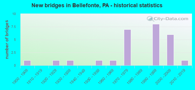
- New bridges - historical statistics
- 11900-1909
- 11920-1929
- 11930-1939
- 11950-1959
- 11960-1969
- 71970-1979
- 81990-1999
- 62000-2009
- 12010-2019
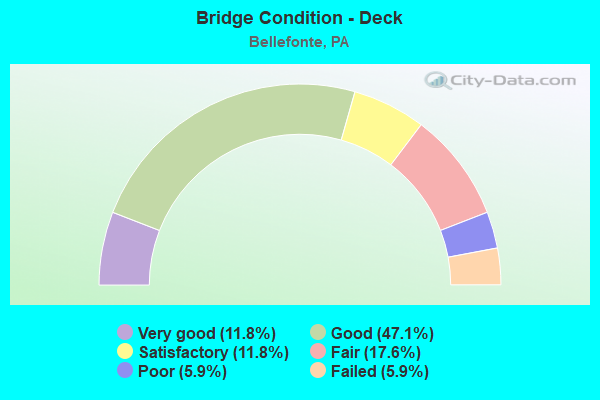
- Bridge Condition - Deck
- 11.8%Very good
- 47.1%Good
- 11.8%Satisfactory
- 17.6%Fair
- 5.9%Poor
- 5.9%Failed
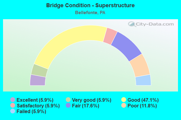
- Bridge Condition - Superstructure
- 5.9%Excellent
- 5.9%Very good
- 47.1%Good
- 5.9%Satisfactory
- 17.6%Fair
- 11.8%Poor
- 5.9%Failed
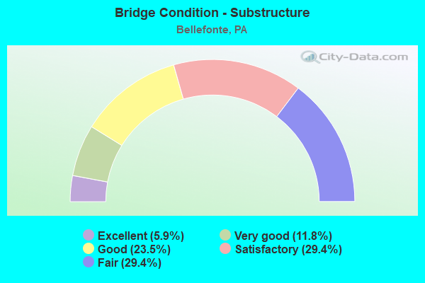
- Bridge Condition - Substructure
- 5.9%Excellent
- 11.8%Very good
- 23.5%Good
- 29.4%Satisfactory
- 29.4%Fair
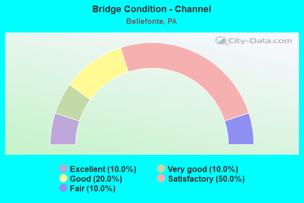
- Bridge Condition - Channel
- 10.0%Excellent
- 10.0%Very good
- 20.0%Good
- 50.0%Satisfactory
- 10.0%Fair
Find on map >> Show street view
Structure Number: 9219, Location: BELLEFONTE (Lat: 40.910739, Lng: -77.740956), Route carried "on" structure: Interstate 99, Year Built: 1972, Year Reconstructed: 1997, Status: Open, Structure Length: 3.23m (10.60ft), Average Daily Traffic: 9,707 (year 2021), Truck Traffic: 21%, Average Future Daily Traffic: 11,801 (year 2040), Design Load: HS 20, Features Intersected: T-422
Minimum Vertical Clearance: 30+ m (98+ ft), Kilometerpoint: 43.523, Lanes on structure: 2, Lanes under structure: 2, Base Highway Network: Yes, Owner: State Highway Agency, Approaching Roadway Width: 11.6m (38.1ft), Skew: 11 degrees, Material/Design: Steel, Design/Construction: Stringer/Multi-beam, Number Of Spans In Main Unit: 1, Length of Maximum Span: 30.5m (100.1ft), Curb or Sidewalk Widths: Left: 0.2m (0.7ft), Right: 0.2m (0.7ft), Curb-To-Curb Width: 13.4m (44.0ft), Out-to-Out Width: 14.6m (47.9ft)
Condition: Deck: Good, Superstructure: Good, Substructure: Satisfactory, Operating Rating: 68.0 metric tons, Method Used To Determine Operating Rating: Load Factor (LF), Inventory Rating: 50.8 metric tons, Method Used To Determine Inventory Rating: Load Factor (LF), Structural Evaluation: Equal to present minimum criteria, Deck Geometry: Superior to present desirable criteria, Underclear: Better than present minimum criteria, Approach Roadway Alignment: Equal to present minimum criteria, Length Of Structure Improvement: 3.20m (10.50ft), Designated Inspection Frequency: Every 24 months, Inspection Date: July 2020, Deck Structure Type: Concrete Cast-file-Place, Wearing Surface/Protective System: Wearing Surface: Monolithic Concrete
Find on map >> Show street view
Structure Number: 9221, Location: BELLEFONTE (Lat: 40.915278, Lng: -77.741392), Route carried "on" structure: Interstate 99, Year Built: 1972, Year Reconstructed: 1997, Status: Open, Structure Length: 4.27m (14.01ft), Average Daily Traffic: 9,707 (year 2021), Truck Traffic: 21%, Average Future Daily Traffic: 11,801 (year 2040), Design Load: HS 20, Features Intersected: SR 550-PA 550
Minimum Vertical Clearance: 30+ m (98+ ft), Kilometerpoint: 44.328, Lanes on structure: 3, Lanes under structure: 3, Base Highway Network: Yes, Owner: State Highway Agency, Approaching Roadway Width: 18.0m (59.1ft), Skew: 10 degrees, Material/Design: Steel, Design/Construction: Stringer/Multi-beam, Number Of Spans In Main Unit: 1, Length of Maximum Span: 42.7m (140.1ft), Curb or Sidewalk Widths: Left: 0.2m (0.7ft), Right: 0.2m (0.7ft), Curb-To-Curb Width: 19.0m (62.3ft), Out-to-Out Width: 20.1m (65.9ft)
Condition: Deck: Good, Superstructure: Good, Substructure: Satisfactory, Operating Rating: 68.9 metric tons, Method Used To Determine Operating Rating: Allowable Stress (AS), Inventory Rating: 22.7 metric tons, Method Used To Determine Inventory Rating: Allowable Stress (AS), Structural Evaluation: Somewhat better than minimum adequacy, Deck Geometry: Superior to present desirable criteria, Underclear: Better than present minimum criteria, Approach Roadway Alignment: Equal to present desirable criteria, Length Of Structure Improvement: 4.50m (14.76ft), Designated Inspection Frequency: Every 24 months, Inspection Date: July 2020, Bridge Improvement Cost: $46,000, Roadway Improvement Cost: $250,000, Total Project Cost: $619,000, Deck Structure Type: Concrete Cast-file-Place, Wearing Surface/Protective System: Wearing Surface: Monolithic Concrete
Find on map >> Show street view
Structure Number: 9379, Location: BELLEFONTE BORO (Lat: 40.907617, Lng: -77.782306), Route carried "on" structure: State highway 150, Year Built: 1934, Status: Open, Structure Length: 1.34m (4.40ft), Average Daily Traffic: 14,844 (year 2022), Truck Traffic: 2%, Average Future Daily Traffic: 17,761 (year 2041), Design Load: H 15, Features Intersected: LOGAN BRANCH
Minimum Vertical Clearance: 30+ m (98+ ft), Kilometerpoint: 9.313, Lanes on structure: 2, Base Highway Network: Yes, Owner: State Highway Agency, Approaching Roadway Width: 13.4m (44.0ft), Material/Design: Concrete, Design/Construction: Tee Beam, Number Of Spans In Main Unit: 1, Length of Maximum Span: 12.8m (42.0ft), Curb or Sidewalk Widths: Left: 1.5m (4.9ft), Right: 1.5m (4.9ft), Curb-To-Curb Width: 12.5m (41.0ft), Out-to-Out Width: 15.5m (50.9ft)
Condition: Deck: Fair, Superstructure: Poor, Substructure: Fair, Channel: Fair, Operating Rating: 55.3 metric tons, Method Used To Determine Operating Rating: Load Factor (LF), Inventory Rating: 33.6 metric tons, Method Used To Determine Inventory Rating: Load Factor (LF), Structural Evaluation: Meets minimum limits, Deck Geometry: Somewhat better than minimum adequacy, Waterway Adequacy: Equal to present desirable criteria, Approach Roadway Alignment: Equal to present desirable criteria, Length Of Structure Improvement: 1.30m (4.27ft), Designated Inspection Frequency: Every 24 months, Inspection Date: April 2021, Bridge Improvement Cost: $36,000, Roadway Improvement Cost: $250,000, Total Project Cost: $487,000, Deck Structure Type: Concrete Cast-file-Place, Wearing Surface/Protective System: Wearing Surface: Bituminous
Find on map >> Show street view
Structure Number: 9557, Location: BELLEFONTE (Lat: 40.901619, Lng: -77.797444), Route carried "on" structure: State highway 550, Year Built: 1952, Status: Open, Structure Length: 4.57m (14.99ft), Average Daily Traffic: 2,113 (year 2020), Truck Traffic: 6%, Average Future Daily Traffic: 3,285 (year 2041), Design Load: HS 20, Features Intersected: SPRING CREEK
Minimum Vertical Clearance: 30+ m (98+ ft), Kilometerpoint: 32.242, Lanes on structure: 2, Owner: State Highway Agency, Approaching Roadway Width: 6.7m (22.0ft), Skew: 3 degrees, Material/Design: Steel continuous, Design/Construction: Stringer/Multi-beam, Number Of Spans In Main Unit: 3, Length of Maximum Span: 22.3m (73.2ft), Curb or Sidewalk Widths: Left: 0.4m (1.3ft), Right: 0.4m (1.3ft), Curb-To-Curb Width: 9.2m (30.2ft), Out-to-Out Width: 9.8m (32.2ft)
Condition: Deck: Fair, Superstructure: Fair, Substructure: Fair, Channel: Good, Operating Rating: 53.5 metric tons, Method Used To Determine Operating Rating: Load Factor (LF), Inventory Rating: 31.8 metric tons, Method Used To Determine Inventory Rating: Load Factor (LF), Structural Evaluation: Somewhat better than minimum adequacy, Deck Geometry: Meets minimum limits, Waterway Adequacy: Equal to present minimum criteria, Approach Roadway Alignment: Equal to present desirable criteria, Length Of Structure Improvement: 4.60m (15.09ft), Designated Inspection Frequency: Every 24 months, Inspection Date: April 2021, Bridge Improvement Cost: $59,000, Roadway Improvement Cost: $250,000, Total Project Cost: $798,000, Deck Structure Type: Closed Grating, Wearing Surface/Protective System: Wearing Surface: Bituminous
Find on map >> Show street view
Structure Number: 9687, Location: 3 MI SW BELLEFONTE (Lat: 40.889781, Lng: -77.794294), Route carried "on" structure: State highway , Year Built: 1995, Status: Open, Structure Length: 3.08m (10.10ft), Average Daily Traffic: 615 (year 2022), Truck Traffic: 1%, Average Future Daily Traffic: 1,006 (year 2040), Design Load: HS 25 or greater, Features Intersected: SPRING CREEK, Facility Carried by Structure: SR 3001
Minimum Vertical Clearance: 30+ m (98+ ft), Kilometerpoint: 2.076, Lanes on structure: 2, Owner: State Highway Agency, Approaching Roadway Width: 8.2m (26.9ft), Skew: 2 degrees, Material/Design: Prestressed concrete, Design/Construction: Stringer/Multi-beam, Number Of Spans In Main Unit: 1, Length of Maximum Span: 27.1m (88.9ft), Curb or Sidewalk Widths: Left: 0.2m (0.7ft), Right: 0.2m (0.7ft), Curb-To-Curb Width: 13.1m (43.0ft), Out-to-Out Width: 14.2m (46.6ft)
Condition: Deck: Very good, Superstructure: Good, Substructure: Very good, Channel: Satisfactory, Inventory Rating: 50.8 metric tons, Method Used To Determine Inventory Rating: Load Factor (LF), Structural Evaluation: Better than present minimum criteria, Deck Geometry: Superior to present desirable criteria, Waterway Adequacy: Better than present minimum criteria, Approach Roadway Alignment: Somewhat better than minimum adequacy, Length Of Structure Improvement: 3.80m (12.47ft), Designated Inspection Frequency: Every 24 months, Inspection Date: September 2020, Deck Structure Type: Concrete Cast-file-Place, Wearing Surface/Protective System: Wearing Surface: Monolithic Concrete, Deck Protection: Epoxy Coated Reinforcing
Find on map >> Show street view
Structure Number: 9705, Location: BELLEFONTE (Lat: 40.911617, Lng: -77.781467), Route carried "on" structure: State highway , Year Built: 1905, Status: Open, Structure Length: 1.22m (4.00ft), Average Daily Traffic: 1,467 (year 2022), Truck Traffic: 6%, Average Future Daily Traffic: 2,114 (year 2041), Features Intersected: MILL RACE, Facility Carried by Structure: SR 3006
Minimum Vertical Clearance: 30+ m (98+ ft), Kilometerpoint: 11.471, Lanes on structure: 2, Owner: State Highway Agency, Approaching Roadway Width: 9.1m (29.9ft), Skew: 1 degrees, Material/Design: Steel, Design/Construction: Stringer/Multi-beam, Number Of Spans In Main Unit: 2, Length of Maximum Span: 5.5m (18.0ft), Curb or Sidewalk Widths: Left: 3.2m (10.5ft), Right: 3.8m (12.5ft), Curb-To-Curb Width: 15.2m (49.9ft), Out-to-Out Width: 23.2m (76.1ft)
Condition: Deck: Satisfactory, Superstructure: Poor, Substructure: Satisfactory, Channel: Satisfactory, Operating Rating: 56.2 metric tons, Method Used To Determine Operating Rating: Load Factor (LF), Inventory Rating: 33.6 metric tons, Method Used To Determine Inventory Rating: Load Factor (LF), Structural Evaluation: Meets minimum limits, Deck Geometry: Superior to present desirable criteria, Waterway Adequacy: Superior to present desirable criteria, Approach Roadway Alignment: Equal to present desirable criteria, Length Of Structure Improvement: 1.20m (3.94ft), Designated Inspection Frequency: Every 24 months, Inspection Date: April 2021, Bridge Improvement Cost: $66,000, Roadway Improvement Cost: $250,000, Total Project Cost: $890,000, Deck Structure Type: Other, Wearing Surface/Protective System: Wearing Surface: Bituminous
Find on map >> Show street view
Structure Number: 9838, Location: 100 FT WEST OF SR 144 (Lat: 40.896519, Lng: -77.772247), Route carried "on" structure: ServiceCity street , Year Built: 1972, Status: Open, Structure Length: 1.13m (3.71ft), Average Daily Traffic: 350 (year 2021), Truck Traffic: 1%, Average Future Daily Traffic: 496 (year 2043), Design Load: HS 20, Features Intersected: LOGAN BRANCH, Facility Carried by Structure: T-384 EPPLY-WHITE
Minimum Vertical Clearance: 30+ m (98+ ft), Kilometerpoint: 0.000, Lanes on structure: 2, Owner: Town or Township Highway Agency, Approaching Roadway Width: 6.1m (20.0ft), Material/Design: Steel, Design/Construction: Stringer/Multi-beam, Number Of Spans In Main Unit: 1, Length of Maximum Span: 10.4m (34.1ft), Curb or Sidewalk Widths: Left: 1.5m (4.9ft), Right: 0.5m (1.6ft), Curb-To-Curb Width: 6.1m (20.0ft), Out-to-Out Width: 8.8m (28.9ft)
Condition: Deck: Fair, Superstructure: Fair, Substructure: Fair, Channel: Satisfactory, Operating Rating: 77.1 metric tons, Method Used To Determine Operating Rating: Load Factor (LF), Inventory Rating: 46.3 metric tons, Method Used To Determine Inventory Rating: Load Factor (LF), Structural Evaluation: Somewhat better than minimum adequacy, Deck Geometry: Meets minimum limits, Waterway Adequacy: Equal to present desirable criteria, Approach Roadway Alignment: Equal to present desirable criteria, Length Of Structure Improvement: 1.70m (5.58ft), Designated Inspection Frequency: Every 24 months, Inspection Date: June 2021, Deck Structure Type: Concrete Cast-file-Place, Wearing Surface/Protective System: Wearing Surface: Monolithic Concrete
Find on map >> Show street view
Structure Number: 9841, Location: 900 FT SW OF SR 3006 (Lat: 40.909803, Lng: -77.793792), Route carried "on" structure: City street , Year Built: 1965, Status: Closed, Structure Length: 1.58m (5.18ft), Average Daily Traffic: 500 (year 2019), Truck Traffic: 1%, Average Future Daily Traffic: 773 (year 2041), Features Intersected: BUFFALO RUN, Facility Carried by Structure: T942 L COLEVLLE RD
Minimum Vertical Clearance: 30+ m (98+ ft), Kilometerpoint: 0.000, Lanes on structure: 2, Owner: Town or Township Highway Agency, Approaching Roadway Width: 7.3m (24.0ft), Skew: 3 degrees, Material/Design: Prestressed concrete, Design/Construction: Box Beam or Girders - Multiple, Number Of Spans In Main Unit: 1, Length of Maximum Span: 15.5m (50.9ft), Curb or Sidewalk Widths: Left: 0.2m (0.7ft), Right: 1.3m (4.3ft), Curb-To-Curb Width: 9.9m (32.5ft), Out-to-Out Width: 13.3m (43.6ft)
Condition: Deck: Failed, Superstructure: Failed, Substructure: Fair, Channel: Satisfactory, Deck Geometry: Equal to present minimum criteria, Waterway Adequacy: Better than present minimum criteria, Approach Roadway Alignment: Equal to present desirable criteria, Bridge Posting: Required (Relationship of Operating Rating to Maximum Legal Load: > 39.9% below), Length Of Structure Improvement: 1.60m (5.25ft), Designated Inspection Frequency: Every 24 months, Inspection Date: June 2021, Bridge Improvement Cost: $9,000, Roadway Improvement Cost: $27,000, Total Project Cost: $123,000, Deck Structure Type: Other, Wearing Surface/Protective System: Wearing Surface: Bituminous, Membrane: Preformed Fabric
Find on map >> Show street view
Structure Number: 9851, Location: 20 FT WEST SR 150 (Lat: 40.914297, Lng: -77.782797), Route carried "on" structure: ServiceCity street , Year Built: 1992, Status: Open, Structure Length: 3.63m (11.91ft), Average Daily Traffic: 3,300 (year 2019), Average Future Daily Traffic: 5,102 (year 2041), Design Load: HS 25 or greater, Features Intersected: SPRING CREEK, Facility Carried by Structure: LAMB STREET
Minimum Vertical Clearance: 30+ m (98+ ft), Kilometerpoint: 0.000, Lanes on structure: 2, Owner: City or Municipal Highway Agency, Approaching Roadway Width: 7.9m (25.9ft), Skew: 2 degrees, Material/Design: Prestressed concrete, Design/Construction: Box Beam or Girders - Single/Spread, Number Of Spans In Main Unit: 3, Length of Maximum Span: 12.2m (40.0ft), Curb or Sidewalk Widths: Left: 0.2m (0.7ft), Right: 1.2m (3.9ft), Curb-To-Curb Width: 10.1m (33.1ft), Out-to-Out Width: 13.0m (42.7ft)
Condition: Deck: Satisfactory, Superstructure: Satisfactory, Substructure: Satisfactory, Channel: Satisfactory, Operating Rating: 70.8 metric tons, Method Used To Determine Operating Rating: Load Factor (LF), Inventory Rating: 32.7 metric tons, Method Used To Determine Inventory Rating: Load Factor (LF), Structural Evaluation: Equal to present minimum criteria, Deck Geometry: Meets minimum limits, Waterway Adequacy: Better than present minimum criteria, Approach Roadway Alignment: Better than present minimum criteria, Length Of Structure Improvement: 4.40m (14.44ft), Designated Inspection Frequency: Every 24 months, Inspection Date: June 2021, Deck Structure Type: Concrete Cast-file-Place, Wearing Surface/Protective System: Wearing Surface: Monolithic Concrete, Deck Protection: Epoxy Coated Reinforcing
Find on map >> Show street view
Structure Number: 9852, Location: .1 MI EAST OF INT SR 3006 (Lat: 40.915900, Lng: -77.787197), Route carried "on" structure: ServiceCity street , Year Built: 1925, Status: Open, Structure Length: 0.88m (2.89ft), Average Daily Traffic: 240 (year 2021), Truck Traffic: 1%, Average Future Daily Traffic: 371 (year 2041), Design Load: H 20, Features Intersected: BUFFALO RUN, Facility Carried by Structure: RAILROAD STREET
Minimum Vertical Clearance: 30+ m (98+ ft), Kilometerpoint: 0.000, Lanes on structure: 1, Owner: City or Municipal Highway Agency, Approaching Roadway Width: 5.2m (17.1ft), Skew: 2 degrees, Material/Design: Steel, Design/Construction: Slab, Number Of Spans In Main Unit: 1, Length of Maximum Span: 7.9m (25.9ft), Curb-To-Curb Width: 4.6m (15.1ft), Out-to-Out Width: 5.3m (17.4ft)
Condition: Deck: Poor, Superstructure: Fair, Substructure: Fair, Channel: Good, Operating Rating: 32.7 metric tons, Method Used To Determine Operating Rating: Field evaluation and documented engineering judgment, Inventory Rating: 19.1 metric tons, Method Used To Determine Inventory Rating: Field evaluation and documented engineering judgment, Structural Evaluation: Somewhat better than minimum adequacy, Deck Geometry: High priority of replacement, Waterway Adequacy: Better than present minimum criteria, Approach Roadway Alignment: Equal to present desirable criteria, Length Of Structure Improvement: 1.10m (3.61ft), Designated Inspection Frequency: Every 24 months, Inspection Date: June 2021, Bridge Improvement Cost: $43,000, Roadway Improvement Cost: $243,000, Total Project Cost: $575,000, Wearing Surface/Protective System: Wearing Surface: Bituminous
Find on map >> Show street view
Structure Number: 39496, Location: BELLEFONTE (Lat: 40.910622, Lng: -77.741408), Route carried "on" structure: Interstate 99, Year Built: 1997, Status: Open, Structure Length: 3.05m (10.01ft), Average Daily Traffic: 9,837 (year 2021), Truck Traffic: 23%, Average Future Daily Traffic: 11,401 (year 2040), Design Load: HS 25 or greater, Features Intersected: T-422
Minimum Vertical Clearance: 30+ m (98+ ft), Kilometerpoint: 43.550, Lanes on structure: 3, Lanes under structure: 2, Base Highway Network: Yes, Owner: State Highway Agency, Approaching Roadway Width: 18.6m (61.0ft), Skew: 11 degrees, Material/Design: Prestressed concrete, Design/Construction: Box Beam or Girders - Single/Spread, Number Of Spans In Main Unit: 1, Length of Maximum Span: 29.9m (98.1ft), Curb or Sidewalk Widths: Left: 0.2m (0.7ft), Right: 0.2m (0.7ft), Curb-To-Curb Width: 18.7m (61.4ft), Out-to-Out Width: 19.7m (64.6ft)
Condition: Deck: Good, Superstructure: Good, Substructure: Good, Operating Rating: 75.3 metric tons, Method Used To Determine Operating Rating: Load Factor (LF), Inventory Rating: 42.6 metric tons, Method Used To Determine Inventory Rating: Load Factor (LF), Structural Evaluation: Better than present minimum criteria, Deck Geometry: Superior to present desirable criteria, Underclear: Better than present minimum criteria, Approach Roadway Alignment: Equal to present desirable criteria, Length Of Structure Improvement: 3.80m (12.47ft), Designated Inspection Frequency: Every 24 months, Inspection Date: July 2020, Deck Structure Type: Concrete Cast-file-Place, Wearing Surface/Protective System: Wearing Surface: Monolithic Concrete, Deck Protection: Epoxy Coated Reinforcing
Find on map >> Show street view
Structure Number: 39497, Location: BELLEFONTE (Lat: 40.915247, Lng: -77.741844), Route carried "on" structure: Interstate 99, Year Built: 1997, Status: Open, Structure Length: 4.39m (14.40ft), Average Daily Traffic: 10,881 (year 2021), Truck Traffic: 19%, Average Future Daily Traffic: 9,344 (year 2038), Design Load: HS 25 or greater, Features Intersected: SR 550-PA 550
Minimum Vertical Clearance: 30+ m (98+ ft), Kilometerpoint: 44.360, Lanes on structure: 2, Lanes under structure: 4, Base Highway Network: Yes, Owner: State Highway Agency, Approaching Roadway Width: 12.2m (40.0ft), Skew: 10 degrees, Material/Design: Prestressed concrete, Design/Construction: Stringer/Multi-beam, Number Of Spans In Main Unit: 1, Length of Maximum Span: 42.7m (140.1ft), Curb or Sidewalk Widths: Left: 0.2m (0.7ft), Right: 0.2m (0.7ft), Curb-To-Curb Width: 12.3m (40.4ft), Out-to-Out Width: 13.4m (44.0ft)
Condition: Deck: Good, Superstructure: Good, Substructure: Good, Inventory Rating: 51.7 metric tons, Method Used To Determine Inventory Rating: Load Factor (LF), Structural Evaluation: Better than present minimum criteria, Deck Geometry: Better than present minimum criteria, Underclear: Superior to present desirable criteria, Approach Roadway Alignment: Equal to present desirable criteria, Length Of Structure Improvement: 5.30m (17.39ft), Designated Inspection Frequency: Every 24 months, Inspection Date: July 2020, Deck Structure Type: Concrete Cast-file-Place, Wearing Surface/Protective System: Wearing Surface: Monolithic Concrete, Deck Protection: Epoxy Coated Reinforcing
Find on map >> Show street view
Structure Number: 40577, Location: BELLEFONTE (Lat: 40.911508, Lng: -77.780753), Route carried "on" structure: State highway , Year Built: 1999, Status: Open, Structure Length: 2.47m (8.10ft), Average Daily Traffic: 1,467 (year 2022), Truck Traffic: 6%, Average Future Daily Traffic: 2,114 (year 2041), Design Load: HS 25 or greater, Features Intersected: SPRING CREEK, Facility Carried by Structure: SR 3006
Minimum Vertical Clearance: 30+ m (98+ ft), Kilometerpoint: 11.471, Lanes on structure: 2, Owner: State Highway Agency, Approaching Roadway Width: 16.2m (53.1ft), Material/Design: Prestressed concrete, Design/Construction: Box Beam or Girders - Single/Spread, Number Of Spans In Main Unit: 1, Length of Maximum Span: 23.5m (77.1ft), Curb or Sidewalk Widths: Left: 4.1m (13.5ft), Right: 3.4m (11.2ft), Curb-To-Curb Width: 16.1m (52.8ft), Out-to-Out Width: 24.4m (80.1ft)
Condition: Deck: Good, Superstructure: Good, Substructure: Very good, Channel: Excellent, Inventory Rating: 61.7 metric tons, Method Used To Determine Inventory Rating: Load Factor (LF), Structural Evaluation: Better than present minimum criteria, Deck Geometry: Superior to present desirable criteria, Waterway Adequacy: Superior to present desirable criteria, Approach Roadway Alignment: Equal to present desirable criteria, Length Of Structure Improvement: 2.30m (7.55ft), Designated Inspection Frequency: Every 24 months, Inspection Date: April 2021, Deck Structure Type: Concrete Cast-file-Place, Wearing Surface/Protective System: Wearing Surface: Monolithic Concrete, Deck Protection: Epoxy Coated Reinforcing
Find on map >> Show street view
Structure Number: 40798, Location: 4 MI SE BELLEFONTE (Lat: 40.910522, Lng: -77.750000), Route carried "on" structure: Interstate 99, Year Built: 2000, Status: Open, Structure Length: 4.45m (14.60ft), Average Daily Traffic: 9,837 (year 2021), Truck Traffic: 23%, Average Future Daily Traffic: 11,401 (year 2040), Design Load: HS 25 or greater, Features Intersected: T-425
Minimum Vertical Clearance: 30+ m (98+ ft), Kilometerpoint: 41.933, Lanes on structure: 3, Lanes under structure: 2, Base Highway Network: Yes, Owner: State Highway Agency, Approaching Roadway Width: 15.2m (49.9ft), Skew: 2 degrees, Material/Design: Prestressed concrete, Design/Construction: Stringer/Multi-beam, Number Of Spans In Main Unit: 1, Length of Maximum Span: 42.7m (140.1ft), Curb or Sidewalk Widths: Left: 0.2m (0.7ft), Right: 0.2m (0.7ft), Curb-To-Curb Width: 15.9m (52.2ft), Out-to-Out Width: 16.8m (55.1ft)
Condition: Deck: Good, Superstructure: Good, Substructure: Good, Inventory Rating: 52.6 metric tons, Method Used To Determine Inventory Rating: Load Factor (LF), Structural Evaluation: Better than present minimum criteria, Deck Geometry: Somewhat better than minimum adequacy, Underclear: Better than present minimum criteria, Approach Roadway Alignment: Equal to present desirable criteria, Length Of Structure Improvement: 5.40m (17.72ft), Designated Inspection Frequency: Every 24 months, Inspection Date: July 2020, Deck Structure Type: Concrete Cast-file-Place, Wearing Surface/Protective System: Wearing Surface: Monolithic Concrete, Deck Protection: Epoxy Coated Reinforcing
Find on map >> Show street view
Structure Number: 43015, Location: 2 MI WEST EXIT 161 (Lat: 40.954939, Lng: -77.750192), Route carried "on" structure: Interstate 80, Year Built: 2005, Status: Open, Structure Length: 2.07m (6.79ft), Average Daily Traffic: 12,454 (year 2021), Truck Traffic: 47%, Average Future Daily Traffic: 16,072 (year 2041), Design Load: HL 93, Features Intersected: SR 1006
Minimum Vertical Clearance: 30+ m (98+ ft), Kilometerpoint: 32.998, Lanes on structure: 2, Lanes under structure: 2, Base Highway Network: Yes, Owner: State Highway Agency, Approaching Roadway Width: 12.2m (40.0ft), Skew: 12 degrees, Material/Design: Prestressed concrete, Design/Construction: Box Beam or Girders - Single/Spread, Number Of Spans In Main Unit: 1, Length of Maximum Span: 19.5m (64.0ft), Curb or Sidewalk Widths: Left: 0.1m (0.3ft), Right: 0.1m (0.3ft), Curb-To-Curb Width: 12.2m (40.0ft), Out-to-Out Width: 13.1m (43.0ft)
Condition: Deck: Good, Superstructure: Very good, Substructure: Good, Operating Rating: 73.5 metric tons, Method Used To Determine Operating Rating: Load Factor (LF), Inventory Rating: 30.8 metric tons, Method Used To Determine Inventory Rating: Load Factor (LF), Structural Evaluation: Better than present minimum criteria, Deck Geometry: Better than present minimum criteria, Underclear: Equal to present minimum criteria, Approach Roadway Alignment: Equal to present desirable criteria, Length Of Structure Improvement: 2.70m (8.86ft), Designated Inspection Frequency: Every 24 months, Inspection Date: April 2021, Deck Structure Type: Concrete Cast-file-Place, Wearing Surface/Protective System: Wearing Surface: Monolithic Concrete, Deck Protection: Epoxy Coated Reinforcing
Find on map >> Show street view
Structure Number: 43355, Location: 2 MI WEST OF EXIT 161 (Lat: 40.954589, Lng: -77.750619), Route carried "on" structure: Interstate 80, Year Built: 2006, Status: Open, Structure Length: 2.26m (7.41ft), Average Daily Traffic: 13,258 (year 2021), Truck Traffic: 46%, Average Future Daily Traffic: 16,418 (year 2041), Design Load: HL 93, Features Intersected: SR 1006
Minimum Vertical Clearance: 30+ m (98+ ft), Kilometerpoint: 32.977, Lanes on structure: 2, Lanes under structure: 2, Base Highway Network: Yes, Owner: State Highway Agency, Approaching Roadway Width: 11.6m (38.1ft), Skew: 13 degrees, Material/Design: Prestressed concrete, Design/Construction: Box Beam or Girders - Single/Spread, Number Of Spans In Main Unit: 1, Length of Maximum Span: 21.3m (69.9ft), Curb or Sidewalk Widths: Left: 0.1m (0.3ft), Right: 0.1m (0.3ft), Curb-To-Curb Width: 12.3m (40.4ft), Out-to-Out Width: 13.1m (43.0ft)
Condition: Deck: Good, Superstructure: Good, Substructure: Satisfactory, Operating Rating: 73.5 metric tons, Method Used To Determine Operating Rating: Load Factor (LF), Inventory Rating: 29.9 metric tons, Method Used To Determine Inventory Rating: Load Factor (LF), Structural Evaluation: Equal to present minimum criteria, Deck Geometry: Better than present minimum criteria, Underclear: Equal to present minimum criteria, Approach Roadway Alignment: Equal to present desirable criteria, Designated Inspection Frequency: Every 24 months, Inspection Date: April 2021, Deck Structure Type: Concrete Cast-file-Place, Wearing Surface/Protective System: Wearing Surface: Monolithic Concrete, Deck Protection: Epoxy Coated Reinforcing
Find on map >> Show street view
Structure Number: 54123, Location: BELLEFONTE (Lat: 40.924894, Lng: -77.779286), Route carried "on" structure: State highway 144, Year Built: 2017, Status: Open, Structure Length: 1.37m (4.49ft), Average Daily Traffic: 8,240 (year 2020), Truck Traffic: 6%, Average Future Daily Traffic: 13,221 (year 2037), Design Load: HL 93, Features Intersected: UNT TO SPRING CREEK
Minimum Vertical Clearance: 30+ m (98+ ft), Kilometerpoint: 24.248, Lanes on structure: 2, Base Highway Network: Yes, Owner: State Highway Agency, Maintenance Responsibility: Private, Approaching Roadway Width: 8.5m (27.9ft), Material/Design: Prestressed concrete, Design/Construction: Box Beam or Girders - Single/Spread, Number Of Spans In Main Unit: 1, Length of Maximum Span: 12.8m (42.0ft), Curb-To-Curb Width: 13.7m (44.9ft), Out-to-Out Width: 14.3m (46.9ft)
Condition: Deck: Very good, Superstructure: Excellent, Substructure: Excellent, Channel: Very good, Operating Rating: 58.6 metric tons, Method Used To Determine Operating Rating: Assigned ratings based on Load and Resistance Factor Design (LRFD) reported by rating factor (RF) using HL93 loadings, Inventory Rating: 45.0 metric tons, Method Used To Determine Inventory Rating: Assigned ratings based on Load and Resistance Factor Design (LRFD) reported by rating factor (RF) using HL93 loadings, Structural Evaluation: Superior to present desirable criteria, Deck Geometry: Superior to present desirable criteria, Waterway Adequacy: Equal to present minimum criteria, Approach Roadway Alignment: Better than present minimum criteria, Designated Inspection Frequency: Every 24 months, Inspection Date: August 2021, Deck Structure Type: Concrete Cast-file-Place, Wearing Surface/Protective System: Wearing Surface: Integral Concrete, Deck Protection: Epoxy Coated Reinforcing
Find on map >> Show street view
Structure Number: 9218, Location: 4 MI SE BELLEFONTE (Lat: 40.910522, Lng: -77.750000), Route carried "under" structure: City street , Year Built: 1973, Structure Length: 0. m, Average Daily Traffic: 50 (year 2004), Features Intersected: T-425, Facility Carried by Structure: SR 99 - I 99
Minimum Vertical Clearance: 4.46m (14.63ft), Kilometerpoint: 0.000, Lanes on structure: 2, Lanes under structure: 2, Material/Design: Steel, Design/Construction: Stringer/Multi-beam, Length of Maximum Span: 36.6m (120.1ft)
Find on map >> Show street view
Structure Number: 9219, Location: BELLEFONTE (Lat: 40.910739, Lng: -77.740956), Route carried "under" structure: City street , Year Built: 1972, Structure Length: 0. m, Average Daily Traffic: 197 (year 1998), Truck Traffic: 9%, Features Intersected: T-422, Facility Carried by Structure: SR 99 - I 99
Minimum Vertical Clearance: 4.76m (15.62ft), Kilometerpoint: 0.000, Lanes on structure: 2, Lanes under structure: 2, Material/Design: Steel, Design/Construction: Stringer/Multi-beam, Length of Maximum Span: 30.5m (100.1ft)
Find on map >> Show street view
Structure Number: 9221, Location: BELLEFONTE (Lat: 40.915278, Lng: -77.741392), Route carried "under" structure: State highway 550, Year Built: 1972, Structure Length: 0. m, Average Daily Traffic: 4,953 (year 2021), Truck Traffic: 5%, Features Intersected: SR 550-PA 550, Facility Carried by Structure: SR 99 - I 99
Minimum Vertical Clearance: 4.90m (16.08ft), Kilometerpoint: 36.873, Lanes on structure: 3, Lanes under structure: 2, Material/Design: Steel, Design/Construction: Stringer/Multi-beam, Length of Maximum Span: 42.7m (140.1ft)
Find on map >> Show street view
Structure Number: 9221, Location: BELLEFONTE (Lat: 40.915278, Lng: -77.741392), Route carried "under" structure: State highway 550, Year Built: 1972, Structure Length: 0. m, Average Daily Traffic: 4,953 (year 2021), Truck Traffic: 5%, Features Intersected: SR 550-PA 550, Facility Carried by Structure: SR 99 - I 99
Minimum Vertical Clearance: 4.93m (16.17ft), Kilometerpoint: 36.873, Lanes on structure: 3, Lanes under structure: 1, Material/Design: Steel, Design/Construction: Stringer/Multi-beam, Length of Maximum Span: 42.7m (140.1ft)
Find on map >> Show street view
Structure Number: 39496, Location: BELLEFONTE (Lat: 40.910622, Lng: -77.741408), Route carried "under" structure: City street , Year Built: 1997, Structure Length: 0. m, Average Daily Traffic: 193 (year 1997), Truck Traffic: 9%, Features Intersected: T-422, Facility Carried by Structure: SR 99 - I 99
Minimum Vertical Clearance: 4.82m (15.81ft), Kilometerpoint: 0.000, Lanes on structure: 3, Lanes under structure: 2, Material/Design: Prestressed concrete, Design/Construction: Box Beam or Girders - Single/Spread, Length of Maximum Span: 29.9m (98.1ft)
Find on map >> Show street view
Structure Number: 39497, Location: BELLEFONTE (Lat: 40.915247, Lng: -77.741844), Route carried "under" structure: State highway 550, Year Built: 1997, Structure Length: 0. m, Average Daily Traffic: 4,953 (year 2021), Truck Traffic: 5%, Features Intersected: SR 550-PA 550, Facility Carried by Structure: SR 99 - I 99
Minimum Vertical Clearance: 5.34m (17.52ft), Kilometerpoint: 36.873, Lanes on structure: 2, Lanes under structure: 1, Material/Design: Prestressed concrete, Design/Construction: Stringer/Multi-beam, Length of Maximum Span: 42.7m (140.1ft)
Find on map >> Show street view
Structure Number: 39497, Location: BELLEFONTE (Lat: 40.915247, Lng: -77.741844), Route carried "under" structure: State highway 550, Year Built: 1997, Structure Length: 0. m, Average Daily Traffic: 4,953 (year 2021), Truck Traffic: 5%, Features Intersected: SR 550-PA 550, Facility Carried by Structure: SR 99 - I 99
Minimum Vertical Clearance: 5.34m (17.52ft), Kilometerpoint: 36.873, Lanes on structure: 2, Lanes under structure: 3, Material/Design: Prestressed concrete, Design/Construction: Stringer/Multi-beam, Length of Maximum Span: 42.7m (140.1ft)
Find on map >> Show street view
Structure Number: 40798, Location: 4 MI SE BELLEFONTE (Lat: 40.910522, Lng: -77.750000), Route carried "under" structure: City street , Year Built: 2000, Structure Length: 0. m, Average Daily Traffic: 50 (year 2016), Features Intersected: T-425, Facility Carried by Structure: SR 99 - I 99
Minimum Vertical Clearance: 4.89m (16.04ft), Kilometerpoint: 0.000, Lanes on structure: 3, Lanes under structure: 2, Material/Design: Prestressed concrete, Design/Construction: Stringer/Multi-beam, Length of Maximum Span: 42.7m (140.1ft)
Find on map >> Show street view
Structure Number: 43015, Location: 2 MI WEST EXIT 161 (Lat: 40.954939, Lng: -77.750192), Route carried "under" structure: State highway , Year Built: 2005, Structure Length: 0. m, Average Daily Traffic: 825 (year 2022), Truck Traffic: 2%, Features Intersected: SR 1006, Facility Carried by Structure: SR 80-I 80 WB
Minimum Vertical Clearance: 4.45m (14.60ft), Kilometerpoint: 3.061, Lanes on structure: 2, Lanes under structure: 2, Material/Design: Prestressed concrete, Design/Construction: Box Beam or Girders - Single/Spread, Length of Maximum Span: 19.5m (64.0ft)
Find on map >> Show street view
Structure Number: 43355, Location: 2 MI WEST OF EXIT 161 (Lat: 40.954589, Lng: -77.750619), Route carried "under" structure: State highway , Year Built: 2006, Structure Length: 0. m, Average Daily Traffic: 825 (year 2022), Truck Traffic: 2%, Features Intersected: SR 1006, Facility Carried by Structure: SR 80-I 80
Minimum Vertical Clearance: 4.42m (14.50ft), Kilometerpoint: 3.061, Lanes on structure: 2, Lanes under structure: 2, Material/Design: Prestressed concrete, Design/Construction: Box Beam or Girders - Single/Spread, Length of Maximum Span: 21.3m (69.9ft)