Bridge Statistics for Bellflower, California (CA)
Condition, Traffic, Stress, Structural Evaluation, Project Costs
- National Bridge Inventory (NBI) Statistics
- 18Number of bridges
- 240ft / 73.4mTotal length
- 1,761,532Total average daily traffic
- 185,851Total average daily truck traffic
- National Bridge Inventory (NBI) Registered Bridges for Bellflower
- No street view available for this location
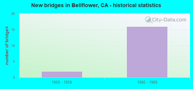
- New bridges - historical statistics
- 21950-1959
- 161960-1969

- Reconstructed bridges - Historical Statistics
- 11960-1969
- 01970-1979
- 01980-1989
- 11990-1999
- 12000-2009


- Bridge Condition - Deck
- 50.0%Good
- 16.7%Satisfactory
- 33.3%Fair

- Bridge Condition - Superstructure
- 91.7%Good
- 8.3%Fair

- Bridge Condition - Channel
- 66.7%Excellent
- 33.3%Very good
Find on map >> Show street view
Structure Number: 53 1257, Location: 07-LA-091-R16.54-BFL (Lat: 33.876608, Lng: -118.108889), Route carried "on" structure: State highway 91, Year Built: 1968, Status: Open, Structure Length: 6.25m (20.51ft), Average Daily Traffic: 242,000 (year 2019), Truck Traffic: 12%, Average Future Daily Traffic: 258,112 (year 2038), Design Load: HS 20, Features Intersected: UP RR
Minimum Vertical Clearance: 30+ m (98+ ft), Kilometerpoint: 16.540, Lanes on structure: 13, Base Highway Network: Yes (, Subroute: 1), Owner: State Highway Agency, Approaching Roadway Width: 55.1m (180.8ft), Skew: 36 degrees, Material/Design: Concrete continuous, Design/Construction: Box Beam or Girders - Multiple, Number Of Spans In Main Unit: 3, Length of Maximum Span: 24.4m (80.1ft), Curb-To-Curb Width: 55.1m (180.8ft), Out-to-Out Width: 56.7m (186.0ft)
Condition: Deck: Fair, Superstructure: Good, Substructure: Good, Operating Rating: 38.2 metric tons, Method Used To Determine Operating Rating: Load and Resistance Factor Rating (LRFR) rating reported by rating factor(RF) method using HL-93 loadings, Inventory Rating: 26.6 metric tons, Method Used To Determine Inventory Rating: Load and Resistance Factor Rating (LRFR) rating reported by rating factor(RF) method using HL-93 loadings, Structural Evaluation: Equal to present minimum criteria, Deck Geometry: Better than present minimum criteria, Underclear: Somewhat better than minimum adequacy, Approach Roadway Alignment: Superior to present desirable criteria, Designated Inspection Frequency: Every 24 months, Inspection Date: August 2021, Deck Structure Type: Concrete Cast-file-Place
Find on map >> Show street view
Structure Number: 53 1698, Location: 07-LA-091-R16.62-BFL (Lat: 33.876481, Lng: -118.108028), Route carried "on" structure: State highway 91, Year Built: 1968, Status: Open, Structure Length: 8.44m (27.69ft), Average Daily Traffic: 242,000 (year 2019), Truck Traffic: 12%, Average Future Daily Traffic: 258,112 (year 2038), Design Load: HS 20, Features Intersected: SAN GABRIEL RIVER
Minimum Vertical Clearance: 30+ m (98+ ft), Kilometerpoint: 16.620, Lanes on structure: 13, Base Highway Network: Yes (, Subroute: 1), Owner: State Highway Agency, Approaching Roadway Width: 52.9m (173.6ft), Skew: 32 degrees, Material/Design: Concrete continuous, Design/Construction: Box Beam or Girders - Multiple, Number Of Spans In Main Unit: 2, Length of Maximum Span: 43.0m (141.1ft), Curb-To-Curb Width: 52.9m (173.6ft), Out-to-Out Width: 54.3m (178.1ft)
Condition: Deck: Good, Superstructure: Good, Substructure: Good, Channel: Very good, Operating Rating: 47.3 metric tons, Method Used To Determine Operating Rating: Load and Resistance Factor Rating (LRFR) rating reported by rating factor(RF) method using HL-93 loadings, Inventory Rating: 33.4 metric tons, Method Used To Determine Inventory Rating: Load and Resistance Factor Rating (LRFR) rating reported by rating factor(RF) method using HL-93 loadings, Structural Evaluation: Better than present minimum criteria, Deck Geometry: Somewhat better than minimum adequacy, Waterway Adequacy: Equal to present desirable criteria, Approach Roadway Alignment: Superior to present desirable criteria, Length Of Structure Improvement: 8.44m (27.69ft), Designated Inspection Frequency: Every 24 months, Inspection Date: August 2021, Deck Structure Type: Concrete Cast-file-Place
Find on map >> Show street view
Structure Number: 53 171, Location: 07-LA-605-R3.40-CRTS (Lat: 33.853258, Lng: -118.095328), Route carried "on" structure: City street Q827, Year Built: 1964, Status: Open, Structure Length: 6.95m (22.80ft), Average Daily Traffic: 2,100 (year 2009), Truck Traffic: 2%, Average Future Daily Traffic: 2,885 (year 2037), Design Load: HS 20, Features Intersected: INTERSTATE 605, Facility Carried by Structure: 195TH STREET
Minimum Vertical Clearance: 30+ m (98+ ft), Kilometerpoint: 0.000, Lanes on structure: 2, Lanes under structure: 10, Owner: State Highway Agency, Approaching Roadway Width: 8.6m (28.2ft), Skew: 1 degrees, Material/Design: Concrete continuous, Design/Construction: Box Beam or Girders - Multiple, Number Of Spans In Main Unit: 4, Length of Maximum Span: 24.7m (81.0ft), Curb or Sidewalk Widths: Left: 1.5m (4.9ft), Right: 1.5m (4.9ft), Curb-To-Curb Width: 8.6m (28.2ft), Out-to-Out Width: 14.0m (45.9ft)
Condition: Deck: Good, Superstructure: Good, Substructure: Good, Operating Rating: 47.3 metric tons, Method Used To Determine Operating Rating: Load and Resistance Factor Rating (LRFR) rating reported by rating factor(RF) method using HL-93 loadings, Inventory Rating: 36.6 metric tons, Method Used To Determine Inventory Rating: Load and Resistance Factor Rating (LRFR) rating reported by rating factor(RF) method using HL-93 loadings, Structural Evaluation: Better than present minimum criteria, Deck Geometry: Meets minimum limits, Underclear: Somewhat better than minimum adequacy, Approach Roadway Alignment: Superior to present desirable criteria, Designated Inspection Frequency: Every 48 months, Inspection Date: July 2019, Deck Structure Type: Concrete Cast-file-Place
Find on map >> Show street view
Structure Number: 53 1718, Location: 07-LA-091-R15.61-BFL (Lat: 33.876000, Lng: -118.125456), Route carried "on" structure: State highway 91, Year Built: 1968, Status: Open, Structure Length: 4.27m (14.01ft), Average Daily Traffic: 242,000 (year 2019), Truck Traffic: 12%, Average Future Daily Traffic: 258,112 (year 2038), Design Load: HS 20, Features Intersected: BELLFLOWER BLVD
Minimum Vertical Clearance: 30+ m (98+ ft), Kilometerpoint: 15.610, Lanes on structure: 11, Lanes under structure: 6, Base Highway Network: Yes (, Subroute: 1), Owner: State Highway Agency, Approaching Roadway Width: 43.7m (143.4ft), Skew: 20 degrees, Material/Design: Prestressed concrete continuous, Design/Construction: Stringer/Multi-beam, Number Of Spans In Main Unit: 1, Number Of Approach Spans: 2, Length of Maximum Span: 26.0m (85.3ft), Curb-To-Curb Width: 43.7m (143.4ft), Out-to-Out Width: 45.1m (148.0ft)
Condition: Deck: Satisfactory, Superstructure: Good, Substructure: Good, Operating Rating: 37.9 metric tons, Method Used To Determine Operating Rating: Load and Resistance Factor Rating (LRFR) rating reported by rating factor(RF) method using HL-93 loadings, Inventory Rating: 24.6 metric tons, Method Used To Determine Inventory Rating: Load and Resistance Factor Rating (LRFR) rating reported by rating factor(RF) method using HL-93 loadings, Structural Evaluation: Equal to present minimum criteria, Deck Geometry: Meets minimum limits, Underclear: Somewhat better than minimum adequacy, Approach Roadway Alignment: Superior to present desirable criteria, Designated Inspection Frequency: Every 24 months, Inspection Date: August 2021, Deck Structure Type: Concrete Cast-file-Place
Find on map >> Show street view
Structure Number: 53 1719, Location: 07-LA-091-R15.87-BFL (Lat: 33.875972, Lng: -118.121061), Route carried "on" structure: State highway 91, Year Built: 1968, Year Reconstructed: 2004, Status: Open, Structure Length: 3.38m (11.09ft), Average Daily Traffic: 242,000 (year 2019), Truck Traffic: 12%, Average Future Daily Traffic: 258,112 (year 2038), Design Load: HS 20, Features Intersected: BIXBY AVE
Minimum Vertical Clearance: 30+ m (98+ ft), Kilometerpoint: 15.870, Lanes on structure: 12, Lanes under structure: 2, Base Highway Network: Yes (, Subroute: 1), Owner: State Highway Agency, Approaching Roadway Width: 51.9m (170.3ft), Skew: 30 degrees, Material/Design: Prestressed concrete continuous, Design/Construction: Stringer/Multi-beam, Number Of Spans In Main Unit: 1, Number Of Approach Spans: 2, Length of Maximum Span: 18.7m (61.4ft), Curb-To-Curb Width: 51.9m (170.3ft), Out-to-Out Width: 53.7m (176.2ft)
Condition: Deck: Satisfactory, Superstructure: Good, Substructure: Good, Operating Rating: 29.8 metric tons, Method Used To Determine Operating Rating: Load and Resistance Factor Rating (LRFR) rating reported by rating factor(RF) method using HL-93 loadings, Inventory Rating: 20.4 metric tons, Method Used To Determine Inventory Rating: Load and Resistance Factor Rating (LRFR) rating reported by rating factor(RF) method using HL-93 loadings, Structural Evaluation: Somewhat better than minimum adequacy, Deck Geometry: Superior to present desirable criteria, Underclear: Equal to present minimum criteria, Approach Roadway Alignment: Superior to present desirable criteria, Designated Inspection Frequency: Every 24 months, Inspection Date: August 2021, Deck Structure Type: Concrete Cast-file-Place
Find on map >> Show street view
Structure Number: 53 175, Location: 07-LA-134-R7.26-GNDL (Lat: 34.156700, Lng: -118.252792), Route carried "on" structure: City street Q410, Year Built: 1968, Status: Open, Structure Length: 7.00m (22.97ft), Average Daily Traffic: 7,800 (year 2015), Truck Traffic: 1%, Average Future Daily Traffic: 8,200 (year 2040), Design Load: HS 20, Features Intersected: STATE ROUTE 134 & RAMPS, Facility Carried by Structure: LOUISE ST
Minimum Vertical Clearance: 30+ m (98+ ft), Kilometerpoint: 0.000, Lanes on structure: 2, Lanes under structure: 12, Owner: State Highway Agency, Approaching Roadway Width: 15.8m (51.8ft), Material/Design: Concrete continuous, Design/Construction: Box Beam or Girders - Multiple, Number Of Spans In Main Unit: 2, Length of Maximum Span: 36.4m (119.4ft), Curb or Sidewalk Widths: Left: 2.1m (6.9ft), Right: 2.1m (6.9ft), Curb-To-Curb Width: 15.8m (51.8ft), Out-to-Out Width: 20.7m (67.9ft)
Condition: Deck: Good, Superstructure: Good, Substructure: Good, Operating Rating: 53.5 metric tons, Method Used To Determine Operating Rating: Load and Resistance Factor Rating (LRFR) rating reported by rating factor(RF) method using HL-93 loadings, Inventory Rating: 41.1 metric tons, Method Used To Determine Inventory Rating: Load and Resistance Factor Rating (LRFR) rating reported by rating factor(RF) method using HL-93 loadings, Structural Evaluation: Better than present minimum criteria, Deck Geometry: Superior to present desirable criteria, Underclear: High priority of corrective action, Approach Roadway Alignment: Equal to present desirable criteria, Designated Inspection Frequency: Every 24 months, Inspection Date: December 2021, Deck Structure Type: Concrete Cast-file-Place
Find on map >> Show street view
Structure Number: 53 1757, Location: 07-LA-091-R15.39-BFL (Lat: 33.875933, Lng: -118.129244), Route carried "on" structure: State highway 91, Year Built: 1968, Year Reconstructed: 2014, Status: Open, Structure Length: 3.11m (10.20ft), Average Daily Traffic: 242,000 (year 2019), Truck Traffic: 12%, Average Future Daily Traffic: 258,112 (year 2038), Design Load: HS 20, Features Intersected: ARDMORE AVE
Minimum Vertical Clearance: 30+ m (98+ ft), Kilometerpoint: 15.390, Lanes on structure: 13, Lanes under structure: 2, Base Highway Network: Yes (, Subroute: 1), Owner: State Highway Agency, Approaching Roadway Width: 53.1m (174.2ft), Skew: 30 degrees, Material/Design: Prestressed concrete continuous, Design/Construction: Stringer/Multi-beam, Number Of Spans In Main Unit: 1, Number Of Approach Spans: 2, Length of Maximum Span: 15.6m (51.2ft), Curb-To-Curb Width: 53.1m (174.2ft), Out-to-Out Width: 54.9m (180.1ft)
Condition: Deck: Good, Superstructure: Good, Substructure: Good, Operating Rating: 34.0 metric tons, Method Used To Determine Operating Rating: Load and Resistance Factor Rating (LRFR) rating reported by rating factor(RF) method using HL-93 loadings, Inventory Rating: 26.2 metric tons, Method Used To Determine Inventory Rating: Load and Resistance Factor Rating (LRFR) rating reported by rating factor(RF) method using HL-93 loadings, Structural Evaluation: Equal to present minimum criteria, Deck Geometry: Equal to present minimum criteria, Underclear: Better than present minimum criteria, Approach Roadway Alignment: Superior to present desirable criteria, Designated Inspection Frequency: Every 24 months, Inspection Date: August 2021, Deck Structure Type: Concrete Cast-file-Place
Find on map >> Show street view
Structure Number: 53 1759, Location: 07-LA-091-R15.10-BFL (Lat: 33.876936, Lng: -118.134142), Route carried "on" structure: State highway 91, Year Built: 1968, Status: Open, Structure Length: 4.15m (13.62ft), Average Daily Traffic: 286,000 (year 2019), Truck Traffic: 12%, Average Future Daily Traffic: 310,000 (year 2041), Design Load: HS 20, Features Intersected: CLARK AVE
Minimum Vertical Clearance: 30+ m (98+ ft), Kilometerpoint: 15.100, Lanes on structure: 11, Lanes under structure: 4, Base Highway Network: Yes (, Subroute: 1), Owner: State Highway Agency, Approaching Roadway Width: 43.7m (143.4ft), Skew: 31 degrees, Material/Design: Prestressed concrete continuous, Design/Construction: Stringer/Multi-beam, Number Of Spans In Main Unit: 3, Length of Maximum Span: 26.5m (86.9ft), Curb-To-Curb Width: 43.7m (143.4ft), Out-to-Out Width: 45.1m (148.0ft)
Condition: Deck: Good, Superstructure: Good, Substructure: Good, Operating Rating: 38.2 metric tons, Method Used To Determine Operating Rating: Load and Resistance Factor Rating (LRFR) rating reported by rating factor(RF) method using HL-93 loadings, Inventory Rating: 29.5 metric tons, Method Used To Determine Inventory Rating: Load and Resistance Factor Rating (LRFR) rating reported by rating factor(RF) method using HL-93 loadings, Structural Evaluation: Better than present minimum criteria, Deck Geometry: Meets minimum limits, Underclear: Somewhat better than minimum adequacy, Approach Roadway Alignment: Superior to present desirable criteria, Designated Inspection Frequency: Every 24 months, Inspection Date: July 2021, Deck Structure Type: Concrete Cast-file-Place
Find on map >> Show street view
Structure Number: 53 1760F, Location: 07-LA-019-6.03-BFL (Lat: 33.876800, Lng: -118.142906), Route carried "on" structure: Ramp State highway 19, Year Built: 1968, Status: Open, Structure Length: 5.42m (17.78ft), Average Daily Traffic: 8,000 (year 2015), Truck Traffic: 4%, Average Future Daily Traffic: 10,304 (year 2041), Design Load: HS 20, Features Intersected: ST RTE 19 (LAKEWOOD BL)
Minimum Vertical Clearance: 30+ m (98+ ft), Kilometerpoint: 6.030, Lanes on structure: 1, Lanes under structure: 6, Base Highway Network: Yes (, Subroute: 1), Owner: State Highway Agency, Approaching Roadway Width: 6.7m (22.0ft), Material/Design: Prestressed concrete continuous, Design/Construction: Stringer/Multi-beam, Number Of Spans In Main Unit: 2, Number Of Approach Spans: 2, Length of Maximum Span: 18.9m (62.0ft), Curb or Sidewalk Widths: Left: 0.6m (2.0ft), Right: 0.0m, Curb-To-Curb Width: 6.7m (22.0ft), Out-to-Out Width: 7.9m (25.9ft)
Condition: Deck: Fair, Superstructure: Good, Substructure: Good, Operating Rating: 33.7 metric tons, Method Used To Determine Operating Rating: Load and Resistance Factor Rating (LRFR) rating reported by rating factor(RF) method using HL-93 loadings, Inventory Rating: 23.7 metric tons, Method Used To Determine Inventory Rating: Load and Resistance Factor Rating (LRFR) rating reported by rating factor(RF) method using HL-93 loadings, Structural Evaluation: Somewhat better than minimum adequacy, Deck Geometry: Equal to present minimum criteria, Underclear: Somewhat better than minimum adequacy, Approach Roadway Alignment: Superior to present desirable criteria, Designated Inspection Frequency: Every 24 months, Inspection Date: July 2021, Deck Structure Type: Concrete Cast-file-Place
Find on map >> Show street view
Structure Number: 53 1760G, Location: 07-LA-019-6.07-BFL (Lat: 33.877414, Lng: -118.142911), Route carried "on" structure: Ramp State highway 19, Year Built: 1968, Status: Open, Structure Length: 5.42m (17.78ft), Average Daily Traffic: 8,000 (year 2015), Truck Traffic: 4%, Average Future Daily Traffic: 10,304 (year 2041), Design Load: HS 20, Features Intersected: ST RTE 19 (LAKEWOOD BL)
Minimum Vertical Clearance: 30+ m (98+ ft), Kilometerpoint: 6.070, Lanes on structure: 1, Lanes under structure: 6, Base Highway Network: Yes (, Subroute: 1), Owner: State Highway Agency, Approaching Roadway Width: 6.7m (22.0ft), Material/Design: Prestressed concrete continuous, Design/Construction: Stringer/Multi-beam, Number Of Spans In Main Unit: 2, Number Of Approach Spans: 2, Length of Maximum Span: 18.9m (62.0ft), Curb or Sidewalk Widths: Left: 0.0m, Right: 0.6m (2.0ft), Curb-To-Curb Width: 6.7m (22.0ft), Out-to-Out Width: 7.9m (25.9ft)
Condition: Deck: Good, Superstructure: Good, Substructure: Good, Operating Rating: 33.7 metric tons, Method Used To Determine Operating Rating: Load and Resistance Factor Rating (LRFR) rating reported by rating factor(RF) method using HL-93 loadings, Inventory Rating: 23.7 metric tons, Method Used To Determine Inventory Rating: Load and Resistance Factor Rating (LRFR) rating reported by rating factor(RF) method using HL-93 loadings, Structural Evaluation: Somewhat better than minimum adequacy, Deck Geometry: Equal to present minimum criteria, Underclear: Somewhat better than minimum adequacy, Approach Roadway Alignment: Superior to present desirable criteria, Designated Inspection Frequency: Every 24 months, Inspection Date: July 2021, Deck Structure Type: Concrete Cast-file-Place
Find on map >> Show street view
Structure Number: 53C0079, Location: 0.3MI W/O I-605 FWY (Lat: 33.901992, Lng: -118.109142), Route carried "on" structure: City street L079, Year Built: 1951, Status: Open, Structure Length: 9.28m (30.45ft), Average Daily Traffic: 28,840 (year 2012), Truck Traffic: 2%, Average Future Daily Traffic: 34,608 (year 2040), Design Load: HS 20, Features Intersected: SAN GABRIEL RIV, Facility Carried by Structure: ROSECRANS AVE
Minimum Vertical Clearance: 30.47m (99.97ft), Kilometerpoint: 0.000, Lanes on structure: 4, Owner: City or Municipal Highway Agency, Approaching Roadway Width: 19.5m (64.0ft), Material/Design: Concrete continuous, Design/Construction: Tee Beam, Number Of Spans In Main Unit: 5, Length of Maximum Span: 20.4m (66.9ft), Curb or Sidewalk Widths: Left: 1.4m (4.6ft), Right: 1.4m (4.6ft), Curb-To-Curb Width: 14.7m (48.2ft), Out-to-Out Width: 18.0m (59.1ft)
Condition: Deck: Fair, Superstructure: Fair, Substructure: Good, Channel: Excellent, Operating Rating: 28.5 metric tons, Method Used To Determine Operating Rating: Load Factor (LF), Inventory Rating: 17.2 metric tons, Method Used To Determine Inventory Rating: Load Factor (LF), Structural Evaluation: Meets minimum limits, Deck Geometry: High priority of replacement, Waterway Adequacy: Superior to present desirable criteria, Approach Roadway Alignment: Better than present minimum criteria, Designated Inspection Frequency: Every 24 months, Inspection Date: June 2020, Deck Structure Type: Concrete Cast-file-Place
Find on map >> Show street view
Structure Number: 53C0083, Location: 0.3MI W/O I-605 FWY (Lat: 33.887714, Lng: -118.108872), Route carried "on" structure: City street L086, Year Built: 1952, Year Reconstructed: 1972, Status: Open, Structure Length: 9.69m (31.79ft), Average Daily Traffic: 27,192 (year 2012), Truck Traffic: 2%, Average Future Daily Traffic: 32,630 (year 2040), Design Load: HS 20, Features Intersected: SAN GABRIEL RIV, Facility Carried by Structure: ALONDRA BLVD
Minimum Vertical Clearance: 30.47m (99.97ft), Kilometerpoint: 0.000, Lanes on structure: 6, Owner: City or Municipal Highway Agency, Approaching Roadway Width: 21.1m (69.2ft), Skew: 20 degrees, Material/Design: Concrete continuous, Design/Construction: Tee Beam, Number Of Spans In Main Unit: 5, Length of Maximum Span: 21.3m (69.9ft), Curb or Sidewalk Widths: Left: 1.5m (4.9ft), Right: 1.5m (4.9ft), Curb-To-Curb Width: 21.1m (69.2ft), Out-to-Out Width: 26.2m (86.0ft)
Condition: Deck: Fair, Superstructure: Good, Substructure: Good, Channel: Excellent, Operating Rating: 78.1 metric tons, Method Used To Determine Operating Rating: Load Factor (LF), Inventory Rating: 47.0 metric tons, Method Used To Determine Inventory Rating: Load Factor (LF), Structural Evaluation: Better than present minimum criteria, Deck Geometry: High priority of replacement, Waterway Adequacy: Superior to present desirable criteria, Approach Roadway Alignment: Better than present minimum criteria, Designated Inspection Frequency: Every 24 months, Inspection Date: June 2020, Deck Structure Type: Concrete Cast-file-Place
Find on map >> Show street view
Structure Number: 53 1718, Location: 07-LA-091-R15.61-BFL (Lat: 33.876000, Lng: -118.125456), Route carried "under" structure: City street , Year Built: 1968, Structure Length: 0. m, Average Daily Traffic: 35,200 (year 2015), Truck Traffic: 2%, Features Intersected: BELLFLOWER BLVD, Facility Carried by Structure: STATE ROUTE 91
Minimum Vertical Clearance: 4.75m (15.58ft), Kilometerpoint: 0.000, Lanes on structure: 11, Lanes under structure: 6, Material/Design: Prestressed concrete continuous, Design/Construction: Stringer/Multi-beam, Length of Maximum Span: 26.0m (85.3ft)
Find on map >> Show street view
Structure Number: 53 172, Location: 07-LA-091-R16.07-BFL (Lat: 33.876047, Lng: -118.117533), Route carried "under" structure: City street , Year Built: 1968, Structure Length: 0. m, Average Daily Traffic: 25,400 (year 2019), Truck Traffic: 2%, Features Intersected: WOODRUFF AVE, Facility Carried by Structure: STATE ROUTE 91
Minimum Vertical Clearance: 4.85m (15.91ft), Kilometerpoint: 0.000, Lanes on structure: 12, Lanes under structure: 4, Material/Design: Prestressed concrete continuous, Design/Construction: Stringer/Multi-beam, Length of Maximum Span: 26.1m (85.6ft)
Find on map >> Show street view
Structure Number: 53 1759, Location: 07-LA-091-R15.10-BFL (Lat: 33.876936, Lng: -118.134142), Route carried "under" structure: City street , Year Built: 1968, Structure Length: 0. m, Average Daily Traffic: 8,000 (year 2020), Truck Traffic: 1%, Features Intersected: CLARK AVE, Facility Carried by Structure: STATE ROUTE 91
Minimum Vertical Clearance: 4.82m (15.81ft), Kilometerpoint: 0.000, Lanes on structure: 11, Lanes under structure: 4, Material/Design: Prestressed concrete continuous, Design/Construction: Stringer/Multi-beam, Length of Maximum Span: 26.5m (86.9ft)
Find on map >> Show street view
Structure Number: 53 176, Location: 07-LA-091-R6.03-BFL (Lat: 33.876939, Lng: -118.142908), Route carried "under" structure: State highway 19, Year Built: 1968, Structure Length: 0. m, Average Daily Traffic: 43,000 (year 2015), Truck Traffic: 4%, Features Intersected: ST RTE 19 (LAKEWOOD BL), Facility Carried by Structure: STATE ROUTE 91
Minimum Vertical Clearance: 4.75m (15.58ft), Kilometerpoint: 6.050, Lanes on structure: 10, Lanes under structure: 6, Material/Design: Prestressed concrete continuous, Design/Construction: Stringer/Multi-beam, Length of Maximum Span: 18.8m (61.7ft)
Find on map >> Show street view
Structure Number: 53 1760F, Location: 07-LA-019-6.03-BFL (Lat: 33.876800, Lng: -118.142906), Route carried "under" structure: State highway 19, Year Built: 1968, Structure Length: 0. m, Average Daily Traffic: 36,000 (year 2015), Truck Traffic: 2%, Features Intersected: ST RTE 19 (LAKEWOOD BL)
Minimum Vertical Clearance: 4.72m (15.49ft), Kilometerpoint: 6.030, Lanes on structure: 1, Lanes under structure: 6, Material/Design: Prestressed concrete continuous, Design/Construction: Stringer/Multi-beam, Length of Maximum Span: 18.9m (62.0ft)
Find on map >> Show street view
Structure Number: 53 1760G, Location: 07-LA-019-6.07-BFL (Lat: 33.877414, Lng: -118.142911), Route carried "under" structure: State highway 19, Year Built: 1968, Structure Length: 0. m, Average Daily Traffic: 36,000 (year 2015), Truck Traffic: 2%, Features Intersected: ST RTE 19 (LAKEWOOD BL)
Minimum Vertical Clearance: 4.72m (15.49ft), Kilometerpoint: 6.070, Lanes on structure: 1, Lanes under structure: 6, Material/Design: Prestressed concrete continuous, Design/Construction: Stringer/Multi-beam, Length of Maximum Span: 18.9m (62.0ft)