Bridge Statistics for Bemidji, Minnesota (MN)
Condition, Traffic, Stress, Structural Evaluation, Project Costs
- National Bridge Inventory (NBI) Statistics
- 43Number of bridges
- 768ft / 234mTotal length
- 213,515Total average daily traffic
- 13,057Total average daily truck traffic
- National Bridge Inventory (NBI) Registered Bridges for Bemidji
- No street view available for this location
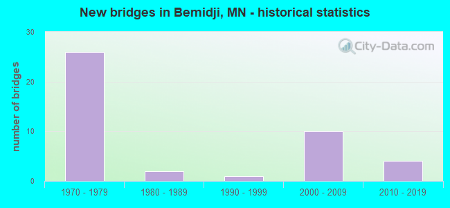
- New bridges - historical statistics
- 261970-1979
- 21980-1989
- 11990-1999
- 102000-2009
- 42010-2019
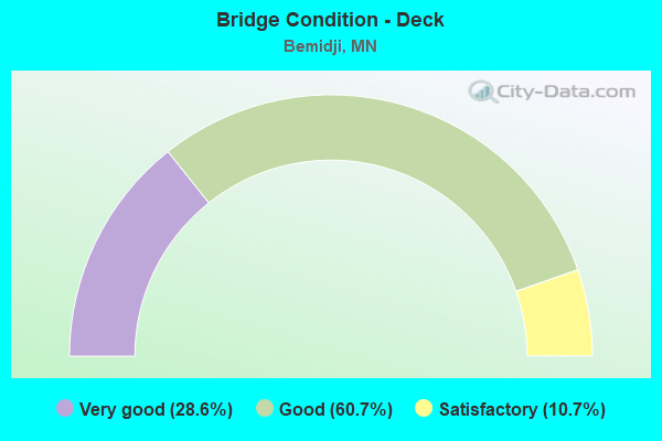
- Bridge Condition - Deck
- 28.6%Very good
- 60.7%Good
- 10.7%Satisfactory
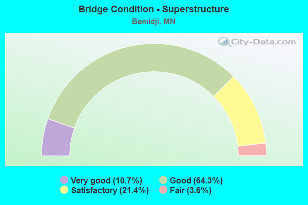
- Bridge Condition - Superstructure
- 10.7%Very good
- 64.3%Good
- 21.4%Satisfactory
- 3.6%Fair
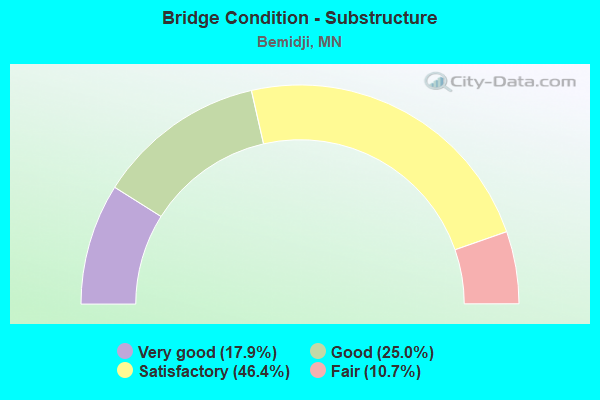
- Bridge Condition - Substructure
- 17.9%Very good
- 25.0%Good
- 46.4%Satisfactory
- 10.7%Fair
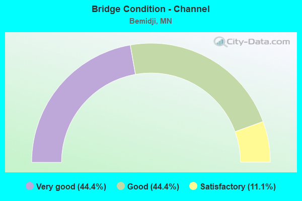
- Bridge Condition - Channel
- 44.4%Very good
- 44.4%Good
- 11.1%Satisfactory
Find on map >> Show street view
Structure Number: 4005, Location: 0.8 MI N OF JCT CSAH 7 (Lat: 47.479428, Lng: -94.918847), Route carried "on" structure: US 2, Year Built: 1978, Status: Open, Structure Length: 8.83m (28.97ft), Average Daily Traffic: 7,850 (year 2018), Truck Traffic: 11%, Average Future Daily Traffic: 8,050 (year 2039), Design Load: HS 20, Features Intersected: BNSF; CP RAIL
Minimum Vertical Clearance: 30+ m (98+ ft), Kilometerpoint: 0.000, Lanes on structure: 2, Base Highway Network: Yes, Owner: State Highway Agency, Approaching Roadway Width: 11.6m (38.1ft), Skew: 3 degrees, Material/Design: Prestressed concrete, Design/Construction: Stringer/Multi-beam, Number Of Spans In Main Unit: 4, Length of Maximum Span: 26.6m (87.3ft), Curb-To-Curb Width: 12.4m (40.7ft), Out-to-Out Width: 13.5m (44.3ft)
Condition: Deck: Good, Superstructure: Good, Substructure: Satisfactory, Operating Rating: 62.0 metric tons, Method Used To Determine Operating Rating: Load Factor (LF), Inventory Rating: 37.2 metric tons, Method Used To Determine Inventory Rating: Load Factor (LF), Structural Evaluation: Equal to present minimum criteria, Deck Geometry: Better than present minimum criteria, Underclear: Equal to present desirable criteria, Approach Roadway Alignment: Equal to present desirable criteria, Designated Inspection Frequency: Every 24 months, Inspection Date: April 2020, Deck Structure Type: Concrete Cast-file-Place, Wearing Surface/Protective System: Wearing Surface: Low Slump Concrete, Deck Protection: Epoxy Coated Reinforcing
Find on map >> Show street view
Structure Number: 4006, Location: 0.8 MI N OF JCT CSAH 7 (Lat: 47.479519, Lng: -94.919272), Route carried "on" structure: US 2, Year Built: 1978, Status: Open, Structure Length: 8.83m (28.97ft), Average Daily Traffic: 7,912 (year 2019), Truck Traffic: 6%, Average Future Daily Traffic: 8,050 (year 2039), Design Load: HS 20, Features Intersected: BNSF; CP RAIL
Minimum Vertical Clearance: 30+ m (98+ ft), Kilometerpoint: 0.000, Lanes on structure: 2, Base Highway Network: Yes, Owner: State Highway Agency, Approaching Roadway Width: 11.6m (38.1ft), Skew: 3 degrees, Material/Design: Prestressed concrete, Design/Construction: Stringer/Multi-beam, Number Of Spans In Main Unit: 4, Length of Maximum Span: 26.6m (87.3ft), Curb-To-Curb Width: 12.4m (40.7ft), Out-to-Out Width: 13.5m (44.3ft)
Condition: Deck: Good, Superstructure: Satisfactory, Substructure: Satisfactory, Operating Rating: 62.0 metric tons, Method Used To Determine Operating Rating: Load Factor (LF), Inventory Rating: 37.2 metric tons, Method Used To Determine Inventory Rating: Load Factor (LF), Structural Evaluation: Equal to present minimum criteria, Deck Geometry: Better than present minimum criteria, Underclear: Equal to present desirable criteria, Approach Roadway Alignment: Equal to present desirable criteria, Designated Inspection Frequency: Every 24 months, Inspection Date: April 2020, Deck Structure Type: Concrete Cast-file-Place, Wearing Surface/Protective System: Wearing Surface: Epoxy Overlay, Deck Protection: Epoxy Coated Reinforcing
Find on map >> Show street view
Structure Number: 4007, Location: 0.5 MI NW OF N JCT TH 71 (Lat: 47.498528, Lng: -94.922486), Route carried "on" structure: US 2, Year Built: 1978, Status: Open, Structure Length: 10.63m (34.88ft), Average Daily Traffic: 2,600 (year 2018), Truck Traffic: 13%, Average Future Daily Traffic: 2,600 (year 2039), Design Load: HS 20, Features Intersected: TH 197 EB
Minimum Vertical Clearance: 30+ m (98+ ft), Kilometerpoint: 0.000, Lanes on structure: 2, Lanes under structure: 2, Base Highway Network: Yes, Owner: State Highway Agency, Approaching Roadway Width: 11.6m (38.1ft), Skew: 5 degrees, Material/Design: Steel continuous, Design/Construction: Stringer/Multi-beam, Number Of Spans In Main Unit: 3, Length of Maximum Span: 49.5m (162.4ft), Curb-To-Curb Width: 12.4m (40.7ft), Out-to-Out Width: 13.5m (44.3ft)
Condition: Deck: Very good, Superstructure: Satisfactory, Substructure: Fair, Operating Rating: 83.7 metric tons, Method Used To Determine Operating Rating: Load Factor (LF), Inventory Rating: 50.2 metric tons, Method Used To Determine Inventory Rating: Load Factor (LF), Structural Evaluation: Somewhat better than minimum adequacy, Deck Geometry: Better than present minimum criteria, Underclear: Better than present minimum criteria, Approach Roadway Alignment: Better than present minimum criteria, Designated Inspection Frequency: Every 24 months, Inspection Date: April 2020, Deck Structure Type: Concrete Cast-file-Place, Wearing Surface/Protective System: Wearing Surface: Low Slump Concrete, Deck Protection: Epoxy Coated Reinforcing
Find on map >> Show street view
Structure Number: 4008, Location: AT THE N JCT TH 71 (Lat: 47.491622, Lng: -94.920556), Route carried "on" structure: US 71, Year Built: 1978, Status: Open, Structure Length: 14.61m (47.93ft), Average Daily Traffic: 4,850 (year 2016), Truck Traffic: 5%, Average Future Daily Traffic: 4,850 (year 2039), Design Load: HS 20, Features Intersected: US 2
Minimum Vertical Clearance: 30+ m (98+ ft), Kilometerpoint: 0.000, Lanes on structure: 1, Lanes under structure: 4, Base Highway Network: Yes, Owner: State Highway Agency, Approaching Roadway Width: 11.0m (36.1ft), Skew: 4 degrees, Material/Design: Steel continuous, Design/Construction: Stringer/Multi-beam, Number Of Spans In Main Unit: 4, Length of Maximum Span: 43.1m (141.4ft), Curb-To-Curb Width: 7.9m (25.9ft), Out-to-Out Width: 8.9m (29.2ft)
Condition: Deck: Good, Superstructure: Satisfactory, Substructure: Satisfactory, Operating Rating: 76.7 metric tons, Method Used To Determine Operating Rating: Load Factor (LF), Inventory Rating: 45.7 metric tons, Method Used To Determine Inventory Rating: Load Factor (LF), Structural Evaluation: Equal to present minimum criteria, Deck Geometry: High priority of corrective action, Underclear: Equal to present minimum criteria, Approach Roadway Alignment: Better than present minimum criteria, Designated Inspection Frequency: Every 24 months, Inspection Date: April 2020, Deck Structure Type: Concrete Cast-file-Place, Wearing Surface/Protective System: Wearing Surface: Low Slump Concrete, Deck Protection: Epoxy Coated Reinforcing
Find on map >> Show street view
Structure Number: 4009, Location: 3.7 MI NW OF S JCT TH 71 (Lat: 47.468594, Lng: -94.915475), Route carried "on" structure: US 2, Year Built: 1978, Status: Open, Structure Length: 4.85m (15.91ft), Average Daily Traffic: 5,200 (year 2016), Truck Traffic: 11%, Average Future Daily Traffic: 5,200 (year 2039), Design Load: HS 20, Features Intersected: CSAH 7
Minimum Vertical Clearance: 30+ m (98+ ft), Kilometerpoint: 0.000, Lanes on structure: 2, Lanes under structure: 4, Base Highway Network: Yes, Owner: State Highway Agency, Approaching Roadway Width: 11.6m (38.1ft), Skew: 1 degrees, Material/Design: Prestressed concrete, Design/Construction: Stringer/Multi-beam, Number Of Spans In Main Unit: 1, Number Of Approach Spans: 2, Length of Maximum Span: 27.4m (89.9ft), Curb-To-Curb Width: 12.4m (40.7ft), Out-to-Out Width: 13.5m (44.3ft)
Condition: Deck: Very good, Superstructure: Good, Substructure: Good, Operating Rating: 83.3 metric tons, Method Used To Determine Operating Rating: Load Factor (LF), Inventory Rating: 38.2 metric tons, Method Used To Determine Inventory Rating: Load Factor (LF), Structural Evaluation: Better than present minimum criteria, Deck Geometry: Better than present minimum criteria, Underclear: Somewhat better than minimum adequacy, Approach Roadway Alignment: Equal to present desirable criteria, Designated Inspection Frequency: Every 24 months, Inspection Date: June 2020, Deck Structure Type: Concrete Cast-file-Place, Wearing Surface/Protective System: Wearing Surface: Low Slump Concrete, Deck Protection: Epoxy Coated Reinforcing
Find on map >> Show street view
Structure Number: 401, Location: 3.7 MI NW OF S JCT TH 71 (Lat: 47.468608, Lng: -94.915908), Route carried "on" structure: US 2, Year Built: 1978, Status: Open, Structure Length: 4.85m (15.91ft), Average Daily Traffic: 5,600 (year 2019), Truck Traffic: 7%, Average Future Daily Traffic: 5,200 (year 2039), Design Load: HS 20, Features Intersected: CSAH 7
Minimum Vertical Clearance: 30+ m (98+ ft), Kilometerpoint: 0.000, Lanes on structure: 2, Lanes under structure: 4, Base Highway Network: Yes, Owner: State Highway Agency, Approaching Roadway Width: 11.6m (38.1ft), Skew: 1 degrees, Material/Design: Prestressed concrete, Design/Construction: Stringer/Multi-beam, Number Of Spans In Main Unit: 1, Number Of Approach Spans: 2, Length of Maximum Span: 27.4m (89.9ft), Curb-To-Curb Width: 12.4m (40.7ft), Out-to-Out Width: 13.5m (44.3ft)
Condition: Deck: Very good, Superstructure: Satisfactory, Substructure: Good, Operating Rating: 83.3 metric tons, Method Used To Determine Operating Rating: Load Factor (LF), Inventory Rating: 38.2 metric tons, Method Used To Determine Inventory Rating: Load Factor (LF), Structural Evaluation: Equal to present minimum criteria, Deck Geometry: Better than present minimum criteria, Underclear: Somewhat better than minimum adequacy, Approach Roadway Alignment: Equal to present desirable criteria, Designated Inspection Frequency: Every 24 months, Inspection Date: April 2020, Deck Structure Type: Concrete Cast-file-Place, Wearing Surface/Protective System: Wearing Surface: Low Slump Concrete, Deck Protection: Epoxy Coated Reinforcing
Find on map >> Show street view
Structure Number: 4011, Location: 2.6 MI NW OF S JCT TH 71 (Lat: 47.456617, Lng: -94.906747), Route carried "on" structure: County highway 11, Year Built: 1979, Year Reconstructed: 2012, Status: Open, Structure Length: 13.08m (42.91ft), Average Daily Traffic: 3,400 (year 2014), Average Future Daily Traffic: 3,400 (year 2039), Design Load: HS 20, Features Intersected: US 2
Minimum Vertical Clearance: 30+ m (98+ ft), Kilometerpoint: 0.000, Lanes on structure: 2, Lanes under structure: 4, Owner: State Highway Agency, Approaching Roadway Width: 12.2m (40.0ft), Skew: 4 degrees, Material/Design: Steel continuous, Design/Construction: Stringer/Multi-beam, Number Of Spans In Main Unit: 4, Length of Maximum Span: 38.1m (125.0ft), Curb-To-Curb Width: 12.2m (40.0ft), Out-to-Out Width: 13.2m (43.3ft)
Condition: Deck: Good, Superstructure: Satisfactory, Substructure: Satisfactory, Operating Rating: 69.6 metric tons, Method Used To Determine Operating Rating: Load Factor (LF), Inventory Rating: 41.5 metric tons, Method Used To Determine Inventory Rating: Load Factor (LF), Structural Evaluation: Equal to present minimum criteria, Deck Geometry: Equal to present minimum criteria, Underclear: Equal to present minimum criteria, Approach Roadway Alignment: Better than present minimum criteria, Designated Inspection Frequency: Every 24 months, Inspection Date: April 2020, Deck Structure Type: Concrete Cast-file-Place, Wearing Surface/Protective System: Wearing Surface: Low Slump Concrete, Deck Protection: Epoxy Coated Reinforcing
Find on map >> Show street view
Structure Number: 4012, Location: AT THE S JCT TH 71 (Lat: 47.431328, Lng: -94.863664), Route carried "on" structure: US 71, Year Built: 1979, Year Reconstructed: 2011, Status: Open, Structure Length: 11.30m (37.07ft), Average Daily Traffic: 3,000 (year 2016), Truck Traffic: 10%, Average Future Daily Traffic: 3,000 (year 2039), Design Load: HS 20, Features Intersected: US 2
Minimum Vertical Clearance: 30+ m (98+ ft), Kilometerpoint: 0.000, Lanes on structure: 3, Lanes under structure: 4, Base Highway Network: Yes, Owner: State Highway Agency, Approaching Roadway Width: 17.7m (58.1ft), Skew: 2 degrees, Material/Design: Prestressed concrete, Design/Construction: Stringer/Multi-beam, Number Of Spans In Main Unit: 4, Length of Maximum Span: 32.7m (107.3ft), Curb-To-Curb Width: 18.5m (60.7ft), Out-to-Out Width: 19.6m (64.3ft)
Condition: Deck: Satisfactory, Superstructure: Satisfactory, Substructure: Satisfactory, Operating Rating: 63.9 metric tons, Method Used To Determine Operating Rating: Load Factor (LF), Inventory Rating: 36.3 metric tons, Method Used To Determine Inventory Rating: Load Factor (LF), Structural Evaluation: Equal to present minimum criteria, Deck Geometry: Superior to present desirable criteria, Underclear: Equal to present minimum criteria, Approach Roadway Alignment: Equal to present desirable criteria, Designated Inspection Frequency: Every 24 months, Inspection Date: April 2020, Deck Structure Type: Concrete Cast-file-Place, Wearing Surface/Protective System: Wearing Surface: Low Slump Concrete, Deck Protection: Epoxy Coated Reinforcing
Find on map >> Show street view
Structure Number: 4013, Location: 1.5 MI NW OF S JCT TH 71 (Lat: 47.445800, Lng: -94.888656), Route carried "on" structure: US 2, Year Built: 1979, Year Reconstructed: 2012, Status: Open, Structure Length: 5.67m (18.60ft), Average Daily Traffic: 5,600 (year 2019), Truck Traffic: 11%, Average Future Daily Traffic: 5,200 (year 2039), Design Load: HS 20, Features Intersected: MISSISSIPPI RIVER
Minimum Vertical Clearance: 30+ m (98+ ft), Kilometerpoint: 0.000, Lanes on structure: 2, Base Highway Network: Yes, Owner: State Highway Agency, Approaching Roadway Width: 11.6m (38.1ft), Material/Design: Prestressed concrete, Design/Construction: Stringer/Multi-beam, Number Of Spans In Main Unit: 2, Length of Maximum Span: 28.0m (91.9ft), Curb-To-Curb Width: 12.6m (41.3ft), Out-to-Out Width: 13.6m (44.6ft)
Condition: Deck: Good, Superstructure: Good, Substructure: Satisfactory, Channel: Good, Operating Rating: 86.5 metric tons, Method Used To Determine Operating Rating: Load Factor (LF), Inventory Rating: 41.2 metric tons, Method Used To Determine Inventory Rating: Load Factor (LF), Structural Evaluation: Equal to present minimum criteria, Deck Geometry: Better than present minimum criteria, Waterway Adequacy: Equal to present desirable criteria, Approach Roadway Alignment: Equal to present desirable criteria, Designated Inspection Frequency: Every 24 months, Inspection Date: April 2020, Deck Structure Type: Concrete Cast-file-Place, Wearing Surface/Protective System: Wearing Surface: Low Slump Concrete, Deck Protection: Epoxy Coated Reinforcing
Find on map >> Show street view
Structure Number: 4014, Location: 1.5 MI NW OF S JCT TH 71 (Lat: 47.445606, Lng: -94.889022), Route carried "on" structure: US 2, Year Built: 1979, Year Reconstructed: 2012, Status: Open, Structure Length: 5.67m (18.60ft), Average Daily Traffic: 5,600 (year 2019), Truck Traffic: 7%, Average Future Daily Traffic: 5,200 (year 2039), Design Load: HS 20, Features Intersected: MISSISSIPPI RIVER
Minimum Vertical Clearance: 30+ m (98+ ft), Kilometerpoint: 0.000, Lanes on structure: 2, Base Highway Network: Yes, Owner: State Highway Agency, Approaching Roadway Width: 11.6m (38.1ft), Material/Design: Prestressed concrete, Design/Construction: Stringer/Multi-beam, Number Of Spans In Main Unit: 2, Length of Maximum Span: 28.0m (91.9ft), Curb-To-Curb Width: 12.6m (41.3ft), Out-to-Out Width: 13.6m (44.6ft)
Condition: Deck: Very good, Superstructure: Good, Substructure: Good, Channel: Good, Operating Rating: 86.5 metric tons, Method Used To Determine Operating Rating: Load Factor (LF), Inventory Rating: 41.2 metric tons, Method Used To Determine Inventory Rating: Load Factor (LF), Structural Evaluation: Better than present minimum criteria, Deck Geometry: Better than present minimum criteria, Waterway Adequacy: Equal to present desirable criteria, Approach Roadway Alignment: Equal to present desirable criteria, Designated Inspection Frequency: Every 24 months, Inspection Date: April 2020, Deck Structure Type: Concrete Cast-file-Place, Wearing Surface/Protective System: Wearing Surface: Low Slump Concrete, Deck Protection: Epoxy Coated Reinforcing
Find on map >> Show street view
Structure Number: 4016, Location: AT THE S JCT TH 71 (Lat: 47.431244, Lng: -94.863319), Route carried "on" structure: US 71, Year Built: 2011, Status: Open, Structure Length: 11.30m (37.07ft), Average Daily Traffic: 4,687 (year 2019), Truck Traffic: 10%, Average Future Daily Traffic: 3,000 (year 2039), Design Load: HL 93, Features Intersected: US 2
Minimum Vertical Clearance: 30+ m (98+ ft), Kilometerpoint: 0.000, Lanes on structure: 4, Lanes under structure: 4, Base Highway Network: Yes, Owner: State Highway Agency, Approaching Roadway Width: 17.7m (58.1ft), Skew: 2 degrees, Material/Design: Prestressed concrete, Design/Construction: Stringer/Multi-beam, Number Of Spans In Main Unit: 4, Length of Maximum Span: 32.7m (107.3ft), Curb-To-Curb Width: 19.5m (64.0ft), Out-to-Out Width: 20.5m (67.3ft)
Condition: Deck: Very good, Superstructure: Good, Substructure: Satisfactory, Operating Rating: 76.9 metric tons, Method Used To Determine Operating Rating: Load Factor (LF), Inventory Rating: 46.1 metric tons, Method Used To Determine Inventory Rating: Load Factor (LF), Structural Evaluation: Equal to present minimum criteria, Deck Geometry: Better than present minimum criteria, Underclear: Superior to present desirable criteria, Approach Roadway Alignment: Equal to present desirable criteria, Designated Inspection Frequency: Every 24 months, Inspection Date: April 2020, Deck Structure Type: Concrete Cast-file-Place, Wearing Surface/Protective System: Wearing Surface: Low Slump Concrete, Deck Protection: Epoxy Coated Reinforcing
Find on map >> Show street view
Structure Number: 4017, Location: 1.6 MI E OF S JCT TH 71 (Lat: 47.430089, Lng: -94.832322), Route carried "on" structure: US 2, Year Built: 1979, Year Reconstructed: 2012, Status: Open, Structure Length: 11.35m (37.24ft), Average Daily Traffic: 2,850 (year 2016), Truck Traffic: 11%, Average Future Daily Traffic: 2,850 (year 2039), Design Load: HS 20, Features Intersected: BNSF; CSAH 50
Minimum Vertical Clearance: 30+ m (98+ ft), Kilometerpoint: 0.000, Lanes on structure: 2, Lanes under structure: 2, Base Highway Network: Yes, Owner: State Highway Agency, Approaching Roadway Width: 11.6m (38.1ft), Skew: 4 degrees, Material/Design: Prestressed concrete, Design/Construction: Stringer/Multi-beam, Number Of Spans In Main Unit: 4, Length of Maximum Span: 37.6m (123.4ft), Curb-To-Curb Width: 12.4m (40.7ft), Out-to-Out Width: 13.5m (44.3ft)
Condition: Deck: Good, Superstructure: Good, Substructure: Satisfactory, Operating Rating: 55.3 metric tons, Method Used To Determine Operating Rating: Load Factor (LF), Inventory Rating: 33.1 metric tons, Method Used To Determine Inventory Rating: Load Factor (LF), Structural Evaluation: Equal to present minimum criteria, Deck Geometry: Better than present minimum criteria, Underclear: Superior to present desirable criteria, Approach Roadway Alignment: Equal to present desirable criteria, Designated Inspection Frequency: Every 24 months, Inspection Date: April 2020, Deck Structure Type: Concrete Cast-file-Place, Wearing Surface/Protective System: Wearing Surface: Low Slump Concrete, Deck Protection: Epoxy Coated Reinforcing
Find on map >> Show street view
Structure Number: 4018, Location: 1.6 MI E OF S JCT TH 71 (Lat: 47.429803, Lng: -94.832031), Route carried "on" structure: US 2, Year Built: 1979, Year Reconstructed: 2012, Status: Open, Structure Length: 11.57m (37.96ft), Average Daily Traffic: 2,974 (year 2019), Truck Traffic: 11%, Average Future Daily Traffic: 2,850 (year 2039), Design Load: HS 20, Features Intersected: BNSF; CSAH 50
Minimum Vertical Clearance: 30+ m (98+ ft), Kilometerpoint: 0.000, Lanes on structure: 2, Lanes under structure: 2, Base Highway Network: Yes, Owner: State Highway Agency, Approaching Roadway Width: 11.6m (38.1ft), Skew: 4 degrees, Material/Design: Prestressed concrete, Design/Construction: Stringer/Multi-beam, Number Of Spans In Main Unit: 4, Length of Maximum Span: 37.6m (123.4ft), Curb-To-Curb Width: 12.4m (40.7ft), Out-to-Out Width: 13.5m (44.3ft)
Condition: Deck: Good, Superstructure: Good, Substructure: Satisfactory, Operating Rating: 55.3 metric tons, Method Used To Determine Operating Rating: Load Factor (LF), Inventory Rating: 33.1 metric tons, Method Used To Determine Inventory Rating: Load Factor (LF), Structural Evaluation: Equal to present minimum criteria, Deck Geometry: Better than present minimum criteria, Underclear: Better than present minimum criteria, Approach Roadway Alignment: Equal to present desirable criteria, Designated Inspection Frequency: Every 24 months, Inspection Date: April 2020, Deck Structure Type: Concrete Cast-file-Place, Wearing Surface/Protective System: Wearing Surface: Low Slump Concrete, Deck Protection: Epoxy Coated Reinforcing
Find on map >> Show street view
Structure Number: 4019, Location: 0.8 MI NW OF S JCT TH 71 (Lat: 47.439256, Lng: -94.876394), Route carried "on" structure: County highway 11, Year Built: 1979, Year Reconstructed: 2012, Status: Open, Structure Length: 13.47m (44.19ft), Average Daily Traffic: 1,050 (year 2014), Average Future Daily Traffic: 1,050 (year 2039), Design Load: HS 20, Features Intersected: US 2
Minimum Vertical Clearance: 30+ m (98+ ft), Kilometerpoint: 0.000, Lanes on structure: 2, Lanes under structure: 4, Owner: State Highway Agency, Approaching Roadway Width: 12.2m (40.0ft), Skew: 4 degrees, Material/Design: Steel continuous, Design/Construction: Stringer/Multi-beam, Number Of Spans In Main Unit: 4, Length of Maximum Span: 42.1m (138.1ft), Curb-To-Curb Width: 12.2m (40.0ft), Out-to-Out Width: 13.2m (43.3ft)
Condition: Deck: Good, Superstructure: Fair, Substructure: Satisfactory, Operating Rating: 72.3 metric tons, Method Used To Determine Operating Rating: Load Factor (LF), Inventory Rating: 43.3 metric tons, Method Used To Determine Inventory Rating: Load Factor (LF), Structural Evaluation: Somewhat better than minimum adequacy, Deck Geometry: Better than present minimum criteria, Underclear: Somewhat better than minimum adequacy, Approach Roadway Alignment: Better than present minimum criteria, Designated Inspection Frequency: Every 24 months, Inspection Date: April 2020, Deck Structure Type: Concrete Cast-file-Place, Wearing Surface/Protective System: Wearing Surface: Low Slump Concrete, Deck Protection: Epoxy Coated Reinforcing
Find on map >> Show street view
Structure Number: 4021, Location: 3.7 MI N OF JCT TH 2 (Lat: 47.543775, Lng: -94.885042), Route carried "on" structure: County highway 15, Year Built: 1975, Status: Open, Structure Length: 14.17m (46.49ft), Average Daily Traffic: 4,050 (year 2014), Average Future Daily Traffic: 4,050 (year 2039), Design Load: HS 20, Features Intersected: US 71
Minimum Vertical Clearance: 30+ m (98+ ft), Kilometerpoint: 0.000, Lanes on structure: 2, Lanes under structure: 4, Owner: State Highway Agency, Approaching Roadway Width: 14.0m (45.9ft), Skew: 5 degrees, Material/Design: Steel continuous, Design/Construction: Stringer/Multi-beam, Number Of Spans In Main Unit: 4, Length of Maximum Span: 42.6m (139.8ft), Curb-To-Curb Width: 14.2m (46.6ft), Out-to-Out Width: 15.3m (50.2ft)
Condition: Deck: Good, Superstructure: Good, Substructure: Fair, Operating Rating: 80.5 metric tons, Method Used To Determine Operating Rating: Load Factor (LF), Inventory Rating: 48.2 metric tons, Method Used To Determine Inventory Rating: Load Factor (LF), Structural Evaluation: Somewhat better than minimum adequacy, Deck Geometry: Superior to present desirable criteria, Underclear: Better than present minimum criteria, Approach Roadway Alignment: Better than present minimum criteria, Designated Inspection Frequency: Every 24 months, Inspection Date: April 2021, Deck Structure Type: Concrete Cast-file-Place, Wearing Surface/Protective System: Wearing Surface: Low Slump Concrete
Find on map >> Show street view
Structure Number: 4023, Location: 4.7 MI NW OF S JCT TH 71 (Lat: 47.483156, Lng: -94.919533), Route carried "on" structure: County highway 6, Year Built: 1978, Status: Open, Structure Length: 8.59m (28.18ft), Average Daily Traffic: 3,350 (year 2014), Average Future Daily Traffic: 3,350 (year 2039), Design Load: HL 93, Features Intersected: US 2
Minimum Vertical Clearance: 30+ m (98+ ft), Kilometerpoint: 0.000, Lanes on structure: 2, Lanes under structure: 4, Owner: State Highway Agency, Approaching Roadway Width: 12.2m (40.0ft), Material/Design: Prestressed concrete, Design/Construction: Stringer/Multi-beam, Number Of Spans In Main Unit: 2, Number Of Approach Spans: 2, Length of Maximum Span: 32.4m (106.3ft), Curb-To-Curb Width: 7.9m (25.9ft), Out-to-Out Width: 13.4m (44.0ft)
Condition: Deck: Very good, Superstructure: Very good, Substructure: Very good, Operating Rating: 64.8 metric tons, Method Used To Determine Operating Rating: Load and Resistance Factor Rating (LRFR) rating reported by rating factor(RF) method using HL-93 loadings, Inventory Rating: 38.9 metric tons, Method Used To Determine Inventory Rating: Load and Resistance Factor Rating (LRFR) rating reported by rating factor(RF) method using HL-93 loadings, Structural Evaluation: Equal to present desirable criteria, Deck Geometry: High priority of corrective action, Underclear: Meets minimum limits, Approach Roadway Alignment: Better than present minimum criteria, Designated Inspection Frequency: Every 24 months, Inspection Date: June 2020, Deck Structure Type: Concrete Cast-file-Place, Wearing Surface/Protective System: Wearing Surface: Low Slump Concrete, Deck Protection: Epoxy Coated Reinforcing
Find on map >> Show street view
Structure Number: 4024, Location: IN BEMIDJI (Lat: 47.467433, Lng: -94.877608), Route carried "on" structure: State highway 197, Year Built: 2002, Status: Open, Structure Length: 6.08m (19.95ft), Average Daily Traffic: 11,600 (year 2018), Truck Traffic: 1%, Average Future Daily Traffic: 11,450 (year 2039), Design Load: HS 25 or greater, Features Intersected: Mississippi River
Minimum Vertical Clearance: 30+ m (98+ ft), Kilometerpoint: 0.000, Lanes on structure: 2, Base Highway Network: Yes, Owner: State Highway Agency, Approaching Roadway Width: 9.1m (29.9ft), Skew: 1 degrees, Material/Design: Prestressed concrete, Design/Construction: Stringer/Multi-beam, Number Of Spans In Main Unit: 3, Length of Maximum Span: 27.7m (90.9ft), Curb-To-Curb Width: 9.6m (31.5ft), Out-to-Out Width: 10.6m (34.8ft)
Condition: Deck: Good, Superstructure: Good, Substructure: Fair, Channel: Very good, Operating Rating: 72.1 metric tons, Method Used To Determine Operating Rating: Load Factor (LF), Inventory Rating: 44.4 metric tons, Method Used To Determine Inventory Rating: Load Factor (LF), Structural Evaluation: Somewhat better than minimum adequacy, Deck Geometry: Meets minimum limits, Waterway Adequacy: Superior to present desirable criteria, Approach Roadway Alignment: Better than present minimum criteria, Designated Inspection Frequency: Every 24 months, Underwater Inspection Frequency: Every 60 months, Inspection Date: May 2021, Underwater Inspection Date: September 2020, Deck Structure Type: Concrete Cast-file-Place, Wearing Surface/Protective System: Wearing Surface: Low Slump Concrete, Deck Protection: Epoxy Coated Reinforcing
Find on map >> Show street view
Structure Number: 4025, Location: 0.9 mi N of jct TH 2 (Lat: 47.445678, Lng: -94.863686), Route carried "on" structure: , Year Built: 2003, Status: Open, Structure Length: 4.22m (13.85ft), Features Intersected: TH 197, Facility Carried by Structure: PEDESTRIAN
Lanes under structure: 2, Owner: State Park, Forest, or Reservation Agency, Skew: 3 degrees, Material/Design: Prestressed concrete, Design/Construction: Stringer/Multi-beam, Number Of Spans In Main Unit: 1, Length of Maximum Span: 41.1m (134.8ft), Out-to-Out Width: 4.3m (14.1ft)
Condition: Deck: Very good, Superstructure: Good, Substructure: Satisfactory, Underclear: Equal to present desirable criteria, Bridge Posting: Required (Relationship of Operating Rating to Maximum Legal Load: > 39.9% below), Designated Inspection Frequency: Every 24 months, Inspection Date: June 2021, Deck Structure Type: Concrete Cast-file-Place, Wearing Surface/Protective System: Wearing Surface: Monolithic Concrete, Deck Protection: Epoxy Coated Reinforcing
Find on map >> Show street view
Structure Number: 4026, Location: 1.3 mi E of jct TH 71 (Lat: 47.430019, Lng: -94.836739), Route carried "on" structure: , Year Built: 2001, Status: Open, Structure Length: 8.30m (27.23ft), Features Intersected: TH 2, Facility Carried by Structure: PEDESTRIAN
Lanes under structure: 4, Owner: State Park, Forest, or Reservation Agency, Skew: 1 degrees, Material/Design: Prestressed concrete, Design/Construction: Stringer/Multi-beam, Number Of Spans In Main Unit: 2, Length of Maximum Span: 41.1m (134.8ft), Out-to-Out Width: 4.4m (14.4ft)
Condition: Deck: Very good, Superstructure: Good, Substructure: Satisfactory, Underclear: Superior to present desirable criteria, Bridge Posting: Required (Relationship of Operating Rating to Maximum Legal Load: > 39.9% below), Designated Inspection Frequency: Every 24 months, Inspection Date: June 2021, Deck Structure Type: Concrete Cast-file-Place, Wearing Surface/Protective System: Wearing Surface: Monolithic Concrete, Deck Protection: Epoxy Coated Reinforcing
Find on map >> Show street view
Structure Number: 4027, Location: .04 MI N TH 197; 1ST E (Lat: 47.460583, Lng: -94.865050), Route carried "on" structure: , Year Built: 2012, Status: Open, Structure Length: 12.94m (42.45ft), Features Intersected: TH 197, Facility Carried by Structure: PEDESTRIAN
Lanes under structure: 6, Owner: State Park, Forest, or Reservation Agency, Skew: 1 degrees, Material/Design: Steel, Design/Construction: Truss - Thru, Number Of Spans In Main Unit: 3, Length of Maximum Span: 61.0m (200.1ft), Out-to-Out Width: 5.1m (16.7ft)
Condition: Deck: Good, Superstructure: Very good, Substructure: Very good, Underclear: Superior to present desirable criteria, Bridge Posting: Required (Relationship of Operating Rating to Maximum Legal Load: > 39.9% below), Designated Inspection Frequency: Every 24 months, Inspection Date: August 2020, Deck Structure Type: Concrete Cast-file-Place, Wearing Surface/Protective System: Wearing Surface: Monolithic Concrete, Deck Protection: Epoxy Coated Reinforcing
Find on map >> Show street view
Structure Number: 4514, Location: 0.6 MI NE OF JCT CSAH 12 (Lat: 47.491611, Lng: -94.832222), Route carried "on" structure: County highway 19, Year Built: 1984, Status: Open, Structure Length: 5.57m (18.27ft), Average Daily Traffic: 1,900 (year 2014), Average Future Daily Traffic: 1,900 (year 2039), Design Load: HL 93, Features Intersected: MISSISSIPPI RIVER
Minimum Vertical Clearance: 30+ m (98+ ft), Kilometerpoint: 0.000, Lanes on structure: 2, Owner: County Highway Agency, Approaching Roadway Width: 12.2m (40.0ft), Material/Design: Prestressed concrete, Design/Construction: Tee Beam, Number Of Spans In Main Unit: 3, Length of Maximum Span: 18.6m (61.0ft), Curb-To-Curb Width: 12.4m (40.7ft), Out-to-Out Width: 13.4m (44.0ft)
Condition: Deck: Good, Superstructure: Good, Substructure: Satisfactory, Channel: Satisfactory, Operating Rating: 46.3 metric tons, Method Used To Determine Operating Rating: Load and Resistance Factor Rating (LRFR) rating reported by rating factor(RF) method using HL-93 loadings, Inventory Rating: 35.6 metric tons, Method Used To Determine Inventory Rating: Load and Resistance Factor Rating (LRFR) rating reported by rating factor(RF) method using HL-93 loadings, Structural Evaluation: Equal to present minimum criteria, Deck Geometry: Better than present minimum criteria, Waterway Adequacy: Superior to present desirable criteria, Approach Roadway Alignment: Equal to present desirable criteria, Designated Inspection Frequency: Every 24 months, Underwater Inspection Frequency: Every 60 months, Inspection Date: September 2020, Underwater Inspection Date: September 2020, Deck Structure Type: Concrete Cast-file-Place, Wearing Surface/Protective System: Wearing Surface: Bituminous
Find on map >> Show street view
Structure Number: 4515, Location: 0.2 MI S OF JCT CSAH 7 (Lat: 47.468869, Lng: -94.885453), Route carried "on" structure: City street 108, Year Built: 1985, Status: Open, Structure Length: 18.85m (61.84ft), Average Daily Traffic: 680 (year 2014), Average Future Daily Traffic: 680 (year 2039), Design Load: HS 20, Features Intersected: BNSF RR; CP RAIL
Minimum Vertical Clearance: 30+ m (98+ ft), Kilometerpoint: 0.000, Lanes on structure: 2, Owner: City or Municipal Highway Agency, Approaching Roadway Width: 9.1m (29.9ft), Skew: 2 degrees, Material/Design: Steel continuous, Design/Construction: Stringer/Multi-beam, Number Of Spans In Main Unit: 7, Length of Maximum Span: 38.1m (125.0ft), Curb or Sidewalk Widths: Left: 0.0m, Right: 1.8m (5.9ft), Curb-To-Curb Width: 9.1m (29.9ft), Out-to-Out Width: 11.8m (38.7ft)
Condition: Deck: Satisfactory, Superstructure: Good, Substructure: Good, Operating Rating: 45.1 metric tons, Method Used To Determine Operating Rating: Load Factor (LF), Inventory Rating: 27.1 metric tons, Method Used To Determine Inventory Rating: Load Factor (LF), Structural Evaluation: Equal to present minimum criteria, Deck Geometry: Equal to present minimum criteria, Underclear: Somewhat better than minimum adequacy, Approach Roadway Alignment: Better than present minimum criteria, Designated Inspection Frequency: Every 24 months, Inspection Date: November 2020, Deck Structure Type: Concrete Cast-file-Place, Wearing Surface/Protective System: Wearing Surface: Monolithic Concrete, Deck Protection: Epoxy Coated Reinforcing
Find on map >> Show street view
Structure Number: 4518, Location: 0.1 MI S OF JCT CSAH 7 (Lat: 47.452825, Lng: -94.948858), Route carried "on" structure: County highway 146, Year Built: 1997, Status: Open, Structure Length: 2.79m (9.15ft), Average Daily Traffic: 93 (year 1996), Average Future Daily Traffic: 93 (year 2029), Design Load: HS 25 or greater, Features Intersected: MISSISSIPPI RIVER
Minimum Vertical Clearance: 30+ m (98+ ft), Kilometerpoint: 0.000, Lanes on structure: 2, Owner: Town or Township Highway Agency, Maintenance Responsibility: County Highway Agency, Approaching Roadway Width: 9.8m (32.2ft), Material/Design: Prestressed concrete, Design/Construction: Stringer/Multi-beam, Number Of Spans In Main Unit: 1, Length of Maximum Span: 27.4m (89.9ft), Curb-To-Curb Width: 9.8m (32.2ft), Out-to-Out Width: 10.8m (35.4ft)
Condition: Deck: Good, Superstructure: Good, Substructure: Very good, Channel: Very good, Operating Rating: 80.5 metric tons, Method Used To Determine Operating Rating: Load Factor (LF), Inventory Rating: 43.9 metric tons, Method Used To Determine Inventory Rating: Load Factor (LF), Structural Evaluation: Better than present minimum criteria, Deck Geometry: Equal to present desirable criteria, Waterway Adequacy: Equal to present desirable criteria, Approach Roadway Alignment: Equal to present desirable criteria, Designated Inspection Frequency: Every 24 months, Inspection Date: September 2020, Deck Structure Type: Concrete Cast-file-Place, Wearing Surface/Protective System: Wearing Surface: Monolithic Concrete, Deck Protection: Epoxy Coated Reinforcing
Find on map >> Show street view
Structure Number: 452, Location: 0.7 MI NW OF JCT CSAH 11 (Lat: 47.446164, Lng: -94.888128), Route carried "on" structure: City street 280, Year Built: 2000, Status: Open, Structure Length: 5.31m (17.42ft), Average Daily Traffic: 267 (year 2000), Average Future Daily Traffic: 267 (year 2029), Design Load: HS 25 or greater, Features Intersected: MISSISSIPPI RIVER
Minimum Vertical Clearance: 30+ m (98+ ft), Kilometerpoint: 0.000, Lanes on structure: 2, Owner: Town or Township Highway Agency, Approaching Roadway Width: 10.8m (35.4ft), Material/Design: Prestressed concrete, Design/Construction: Stringer/Multi-beam, Number Of Spans In Main Unit: 2, Length of Maximum Span: 26.3m (86.3ft), Curb-To-Curb Width: 10.8m (35.4ft), Out-to-Out Width: 11.7m (38.4ft)
Condition: Deck: Good, Superstructure: Good, Substructure: Good, Channel: Good, Operating Rating: 70.8 metric tons, Method Used To Determine Operating Rating: Load Factor (LF), Inventory Rating: 38.5 metric tons, Method Used To Determine Inventory Rating: Load Factor (LF), Structural Evaluation: Better than present minimum criteria, Deck Geometry: Better than present minimum criteria, Waterway Adequacy: Equal to present desirable criteria, Approach Roadway Alignment: Equal to present desirable criteria, Designated Inspection Frequency: Every 24 months, Underwater Inspection Frequency: Every 60 months, Inspection Date: September 2020, Underwater Inspection Date: September 2020, Deck Structure Type: Concrete Cast-file-Place, Wearing Surface/Protective System: Wearing Surface: Monolithic Concrete, Deck Protection: Epoxy Coated Reinforcing
Find on map >> Show street view
Structure Number: 4521, Location: 1.1 mi S of jct CSAH 7 (Lat: 47.451114, Lng: -94.906708), Route carried "on" structure: County highway 11, Year Built: 2001, Status: Open, Structure Length: 3.51m (11.52ft), Average Daily Traffic: 3,400 (year 2014), Average Future Daily Traffic: 3,400 (year 2039), Design Load: HS 25 or greater, Features Intersected: Mississippi River
Minimum Vertical Clearance: 30+ m (98+ ft), Kilometerpoint: 0.000, Lanes on structure: 2, Owner: County Highway Agency, Approaching Roadway Width: 12.2m (40.0ft), Material/Design: Prestressed concrete, Design/Construction: Stringer/Multi-beam, Number Of Spans In Main Unit: 1, Length of Maximum Span: 34.6m (113.5ft), Curb-To-Curb Width: 13.4m (44.0ft), Out-to-Out Width: 14.4m (47.2ft)
Condition: Deck: Satisfactory, Superstructure: Good, Substructure: Very good, Channel: Very good, Operating Rating: 83.9 metric tons, Method Used To Determine Operating Rating: Load Factor (LF), Inventory Rating: 35.6 metric tons, Method Used To Determine Inventory Rating: Load Factor (LF), Structural Evaluation: Better than present minimum criteria, Deck Geometry: Better than present minimum criteria, Waterway Adequacy: Equal to present desirable criteria, Approach Roadway Alignment: Equal to present desirable criteria, Designated Inspection Frequency: Every 24 months, Inspection Date: September 2020, Deck Structure Type: Concrete Cast-file-Place, Wearing Surface/Protective System: Wearing Surface: Low Slump Concrete, Deck Protection: Epoxy Coated Reinforcing
Find on map >> Show street view
Structure Number: 4522, Location: 0.5 MI W OF JCT CR 401 (Lat: 47.436467, Lng: -94.894103), Route carried "on" structure: County highway 11, Year Built: 2003, Status: Open, Structure Length: 3.09m (10.14ft), Average Daily Traffic: 3,400 (year 2014), Average Future Daily Traffic: 3,400 (year 2039), Design Load: HS 25 or greater, Features Intersected: SCHOOLCRAFT RIVER
Minimum Vertical Clearance: 30+ m (98+ ft), Kilometerpoint: 0.000, Lanes on structure: 2, Owner: County Highway Agency, Approaching Roadway Width: 12.2m (40.0ft), Skew: 3 degrees, Material/Design: Prestressed concrete, Design/Construction: Stringer/Multi-beam, Number Of Spans In Main Unit: 1, Length of Maximum Span: 28.2m (92.5ft), Curb-To-Curb Width: 13.4m (44.0ft), Out-to-Out Width: 14.4m (47.2ft)
Condition: Deck: Good, Superstructure: Good, Substructure: Good, Channel: Good, Operating Rating: 73.8 metric tons, Method Used To Determine Operating Rating: Load Factor (LF), Inventory Rating: 40.5 metric tons, Method Used To Determine Inventory Rating: Load Factor (LF), Structural Evaluation: Better than present minimum criteria, Deck Geometry: Better than present minimum criteria, Waterway Adequacy: Equal to present desirable criteria, Approach Roadway Alignment: Equal to present desirable criteria, Designated Inspection Frequency: Every 24 months, Inspection Date: September 2020, Deck Structure Type: Concrete Cast-file-Place, Wearing Surface/Protective System: Wearing Surface: Monolithic Concrete, Deck Protection: Epoxy Coated Reinforcing
Find on map >> Show street view
Structure Number: 4524, Location: 1.5 MI N CITY LIM LIVINIA (Lat: 47.537056, Lng: -94.810528), Route carried "on" structure: County highway 19, Year Built: 2007, Status: Open, Structure Length: 3.10m (10.17ft), Average Daily Traffic: 1,200 (year 2014), Average Future Daily Traffic: 1,200 (year 2039), Design Load: HS 25 or greater, Features Intersected: BASS CREEK
Minimum Vertical Clearance: 30+ m (98+ ft), Kilometerpoint: 0.000, Lanes on structure: 2, Owner: County Highway Agency, Approaching Roadway Width: 11.0m (36.1ft), Material/Design: Prestressed concrete, Design/Construction: Stringer/Multi-beam, Number Of Spans In Main Unit: 1, Length of Maximum Span: 29.6m (97.1ft), Curb-To-Curb Width: 11.0m (36.1ft), Out-to-Out Width: 11.6m (38.1ft)
Condition: Deck: Good, Superstructure: Very good, Substructure: Very good, Channel: Very good, Operating Rating: 82.9 metric tons, Method Used To Determine Operating Rating: Load Factor (LF), Inventory Rating: 46.9 metric tons, Method Used To Determine Inventory Rating: Load Factor (LF), Structural Evaluation: Equal to present desirable criteria, Deck Geometry: Equal to present minimum criteria, Waterway Adequacy: Equal to present desirable criteria, Approach Roadway Alignment: Better than present minimum criteria, Designated Inspection Frequency: Every 24 months, Inspection Date: June 2021, Deck Structure Type: Concrete Cast-file-Place, Wearing Surface/Protective System: Wearing Surface: Monolithic Concrete, Deck Protection: Epoxy Coated Reinforcing
Find on map >> Show street view
Structure Number: 4525, Location: 0.9 MI S JCT CSAH 20 (Lat: 47.531558, Lng: -94.800461), Route carried "on" structure: County highway 19, Year Built: 2007, Status: Open, Structure Length: 1.75m (5.74ft), Average Daily Traffic: 1,200 (year 2014), Average Future Daily Traffic: 1,200 (year 2039), Design Load: HL 93, Features Intersected: PAUL BUNYAN STATE TRAIL
Minimum Vertical Clearance: 30+ m (98+ ft), Kilometerpoint: 0.000, Lanes on structure: 2, Owner: County Highway Agency, Approaching Roadway Width: 11.0m (36.1ft), Material/Design: Concrete continuous, Design/Construction: Frame, Number Of Spans In Main Unit: 1, Length of Maximum Span: 15.6m (51.2ft), Curb-To-Curb Width: 11.0m (36.1ft), Out-to-Out Width: 11.6m (38.1ft)
Condition: Deck: Good, Superstructure: Good, Substructure: Good, Operating Rating: 99.6 metric tons, Method Used To Determine Operating Rating: Load Factor (LF), Inventory Rating: 64.0 metric tons, Method Used To Determine Inventory Rating: Load Factor (LF), Structural Evaluation: Better than present minimum criteria, Deck Geometry: Equal to present minimum criteria, Approach Roadway Alignment: Better than present minimum criteria, Designated Inspection Frequency: Every 24 months, Inspection Date: June 2021, Deck Structure Type: Concrete Cast-file-Place, Wearing Surface/Protective System: Wearing Surface: Monolithic Concrete, Deck Protection: Epoxy Coated Reinforcing
Find on map >> Show street view
Structure Number: 4007, Location: 0.5 MI NW OF N JCT TH 71 (Lat: 47.498528, Lng: -94.922486), Route carried "under" structure: State highway 197, Year Built: 1978, Structure Length: 0. m, Average Daily Traffic: 6,750 (year 2004), Truck Traffic: 2%, Features Intersected: TH 197 EB, Facility Carried by Structure: US 2
Minimum Vertical Clearance: 5.00m (16.40ft), Kilometerpoint: 0.000, Lanes on structure: 2, Lanes under structure: 2, Material/Design: Steel continuous, Design/Construction: Stringer/Multi-beam, Length of Maximum Span: 49.5m (162.4ft)
Find on map >> Show street view
Structure Number: 4008, Location: AT THE N JCT TH 71 (Lat: 47.491622, Lng: -94.920556), Route carried "under" structure: US 2, Year Built: 1978, Structure Length: 0. m, Average Daily Traffic: 5,241 (year 2019), Truck Traffic: 12%, Features Intersected: US 2, Facility Carried by Structure: US 71
Minimum Vertical Clearance: 5.15m (16.90ft), Kilometerpoint: 0.000, Lanes on structure: 1, Lanes under structure: 4, Material/Design: Steel continuous, Design/Construction: Stringer/Multi-beam, Length of Maximum Span: 43.1m (141.4ft)
Find on map >> Show street view
Structure Number: 4009, Location: 3.7 MI NW OF S JCT TH 71 (Lat: 47.468594, Lng: -94.915475), Route carried "under" structure: County highway 7, Year Built: 1978, Structure Length: 0. m, Average Daily Traffic: 5,800 (year 2003), Features Intersected: CSAH 7, Facility Carried by Structure: US 2
Minimum Vertical Clearance: 5.03m (16.50ft), Kilometerpoint: 0.000, Lanes on structure: 2, Lanes under structure: 4, Material/Design: Prestressed concrete, Design/Construction: Stringer/Multi-beam, Length of Maximum Span: 27.4m (89.9ft)
Find on map >> Show street view
Structure Number: 401, Location: 3.7 MI NW OF S JCT TH 71 (Lat: 47.468608, Lng: -94.915908), Route carried "under" structure: County highway 7, Year Built: 1978, Structure Length: 0. m, Average Daily Traffic: 5,800 (year 2003), Features Intersected: CSAH 7, Facility Carried by Structure: US 2
Minimum Vertical Clearance: 5.00m (16.40ft), Kilometerpoint: 0.000, Lanes on structure: 2, Lanes under structure: 4, Material/Design: Prestressed concrete, Design/Construction: Stringer/Multi-beam, Length of Maximum Span: 27.4m (89.9ft)
Find on map >> Show street view
Structure Number: 4011, Location: 2.6 MI NW OF S JCT TH 71 (Lat: 47.456617, Lng: -94.906747), Route carried "under" structure: US 2, Year Built: 1979, Structure Length: 0. m, Average Daily Traffic: 11,200 (year 2019), Truck Traffic: 7%, Features Intersected: US 2, Facility Carried by Structure: CSAH 11
Minimum Vertical Clearance: 5.18m (16.99ft), Kilometerpoint: 0.000, Lanes on structure: 2, Lanes under structure: 4, Material/Design: Steel continuous, Design/Construction: Stringer/Multi-beam, Length of Maximum Span: 38.1m (125.0ft)
Find on map >> Show street view
Structure Number: 4012, Location: AT THE S JCT TH 71 (Lat: 47.431328, Lng: -94.863664), Route carried "under" structure: US 2, Year Built: 1979, Structure Length: 0. m, Average Daily Traffic: 5,947 (year 2019), Truck Traffic: 11%, Features Intersected: US 2, Facility Carried by Structure: US 71
Minimum Vertical Clearance: 5.70m (18.70ft), Kilometerpoint: 0.000, Lanes on structure: 3, Lanes under structure: 4, Material/Design: Prestressed concrete, Design/Construction: Stringer/Multi-beam, Length of Maximum Span: 32.7m (107.3ft)
Find on map >> Show street view
Structure Number: 4016, Location: AT THE S JCT TH 71 (Lat: 47.431244, Lng: -94.863319), Route carried "under" structure: US 2, Year Built: 2011, Structure Length: 0. m, Average Daily Traffic: 5,947 (year 2019), Truck Traffic: 11%, Features Intersected: US 2, Facility Carried by Structure: US 71
Minimum Vertical Clearance: 5.64m (18.50ft), Kilometerpoint: 0.000, Lanes under structure: 4, Material/Design: Prestressed concrete, Design/Construction: Stringer/Multi-beam, Length of Maximum Span: 32.7m (107.3ft)
Find on map >> Show street view
Structure Number: 4017, Location: 1.6 MI E OF S JCT TH 71 (Lat: 47.430089, Lng: -94.832322), Route carried "under" structure: County highway 50, Year Built: 1979, Structure Length: 0. m, Average Daily Traffic: 4,100 (year 2003), Features Intersected: BNSF; CSAH 50, Facility Carried by Structure: US 2
Minimum Vertical Clearance: 5.12m (16.80ft), Kilometerpoint: 0.000, Lanes on structure: 2, Lanes under structure: 2, Material/Design: Prestressed concrete, Design/Construction: Stringer/Multi-beam, Length of Maximum Span: 37.6m (123.4ft)
Find on map >> Show street view
Structure Number: 4018, Location: 1.6 MI E OF S JCT TH 71 (Lat: 47.429803, Lng: -94.832031), Route carried "under" structure: County highway 50, Year Built: 1979, Structure Length: 0. m, Average Daily Traffic: 4,100 (year 2003), Features Intersected: BNSF; CSAH 50, Facility Carried by Structure: US 2
Minimum Vertical Clearance: 5.18m (16.99ft), Kilometerpoint: 0.000, Lanes on structure: 2, Lanes under structure: 2, Material/Design: Prestressed concrete, Design/Construction: Stringer/Multi-beam, Length of Maximum Span: 37.6m (123.4ft)
Find on map >> Show street view
Structure Number: 4019, Location: 0.8 MI NW OF S JCT TH 71 (Lat: 47.439256, Lng: -94.876394), Route carried "under" structure: US 2, Year Built: 1979, Structure Length: 0. m, Average Daily Traffic: 11,200 (year 2019), Truck Traffic: 7%, Features Intersected: US 2, Facility Carried by Structure: CSAH 11
Minimum Vertical Clearance: 5.46m (17.91ft), Kilometerpoint: 0.000, Lanes on structure: 2, Lanes under structure: 4, Material/Design: Steel continuous, Design/Construction: Stringer/Multi-beam, Length of Maximum Span: 42.1m (138.1ft)
Find on map >> Show street view
Structure Number: 4021, Location: 3.7 MI N OF JCT TH 2 (Lat: 47.543775, Lng: -94.885042), Route carried "under" structure: US 71, Year Built: 1975, Structure Length: 0. m, Average Daily Traffic: 4,132 (year 2019), Truck Traffic: 10%, Features Intersected: US 71, Facility Carried by Structure: CSAH 15
Minimum Vertical Clearance: 5.00m (16.40ft), Kilometerpoint: 0.000, Lanes on structure: 2, Lanes under structure: 4, Material/Design: Steel continuous, Design/Construction: Stringer/Multi-beam, Length of Maximum Span: 42.6m (139.8ft)
Find on map >> Show street view
Structure Number: 4023, Location: 4.7 MI NW OF S JCT TH 71 (Lat: 47.483156, Lng: -94.919533), Route carried "under" structure: US 2, Year Built: 1978, Structure Length: 0. m, Average Daily Traffic: 15,824 (year 2019), Truck Traffic: 6%, Features Intersected: US 2, Facility Carried by Structure: CSAH 6
Minimum Vertical Clearance: 5.70m (18.70ft), Kilometerpoint: 0.000, Lanes on structure: 2, Lanes under structure: 4, Material/Design: Prestressed concrete, Design/Construction: Stringer/Multi-beam, Length of Maximum Span: 32.4m (106.3ft)
Find on map >> Show street view
Structure Number: 4025, Location: 0.9 mi N of jct TH 2 (Lat: 47.445678, Lng: -94.863686), Route carried "under" structure: State highway 197, Year Built: 2003, Structure Length: 0. m, Average Daily Traffic: 5,947 (year 2019), Truck Traffic: 12%, Features Intersected: TH 197, Facility Carried by Structure: PEDESTRIAN
Minimum Vertical Clearance: 5.61m (18.41ft), Kilometerpoint: 0.000, Lanes on structure: 2, Lanes under structure: 2, Material/Design: Prestressed concrete, Design/Construction: Stringer/Multi-beam, Length of Maximum Span: 41.1m (134.8ft)
Find on map >> Show street view
Structure Number: 4026, Location: 1.3 mi E of jct TH 71 (Lat: 47.430019, Lng: -94.836739), Route carried "under" structure: US 2, Year Built: 2001, Structure Length: 0. m, Average Daily Traffic: 5,947 (year 2019), Truck Traffic: 11%, Features Intersected: TH 2, Facility Carried by Structure: PEDESTRIAN
Minimum Vertical Clearance: 5.55m (18.21ft), Kilometerpoint: 0.000, Lanes on structure: 4, Lanes under structure: 4, Material/Design: Prestressed concrete, Design/Construction: Stringer/Multi-beam, Length of Maximum Span: 41.1m (134.8ft)
Find on map >> Show street view
Structure Number: 4027, Location: .04 MI N TH 197; 1ST E (Lat: 47.460583, Lng: -94.865050), Route carried "under" structure: State highway 197, Year Built: 2012, Structure Length: 0. m, Average Daily Traffic: 21,267 (year 2019), Truck Traffic: 6%, Features Intersected: TH 197, Facility Carried by Structure: PEDESTRIAN
Minimum Vertical Clearance: 5.43m (17.81ft), Kilometerpoint: 0.000, Lanes under structure: 6, Material/Design: Steel, Design/Construction: Truss - Thru, Length of Maximum Span: 61.0m (200.1ft)