Bridge Statistics for Bennington, New York (NY)
Condition, Traffic, Stress, Structural Evaluation, Project Costs
- National Bridge Inventory (NBI) Statistics
- 18Number of bridges
- 125ft / 37.9mTotal length
- $23,211,000Total costs
- 41,962Total average daily traffic
- 1,901Total average daily truck traffic
- National Bridge Inventory (NBI) Registered Bridges for Bennington
- No street view available for this location
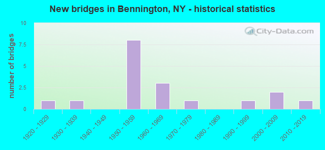
- New bridges - historical statistics
- 11920-1929
- 11930-1939
- 81950-1959
- 31960-1969
- 11970-1979
- 11990-1999
- 22000-2009
- 12010-2019

- Reconstructed bridges - Historical Statistics
- 21980-1989
- 21990-1999
- 22000-2009


- Bridge Condition - Deck
- 18.2%Very good
- 36.4%Good
- 36.4%Satisfactory
- 9.1%Poor

- Bridge Condition - Superstructure
- 18.2%Very good
- 27.3%Good
- 27.3%Satisfactory
- 9.1%Fair
- 18.2%Poor

- Bridge Condition - Substructure
- 9.1%Excellent
- 9.1%Very good
- 18.2%Good
- 45.5%Satisfactory
- 18.2%Fair

- Bridge Condition - Channel
- 14.3%Very good
- 28.6%Good
- 42.9%Satisfactory
- 14.3%Fair

- Bridge Condition - Culverts
- 20.0%Excellent
- 60.0%Satisfactory
- 20.0%Fair
Find on map >> Show street view
Structure Number: 103003, Location: 1.5MI N JCT RTS 77 + 20A (Lat: 42.791989, Lng: -78.396700), Route carried "on" structure: State highway 77, Year Built: 1953, Year Reconstructed: 1992, Status: Open, Structure Length: 1.71m (5.61ft), Average Daily Traffic: 2,091 (year 2017), Truck Traffic: 15%, Average Future Daily Traffic: 2,181 (year 2040), Design Load: HS 20, Features Intersected: CAYUGA CREEK
Minimum Vertical Clearance: 30+ m (98+ ft), Kilometerpoint: 15.929, Lanes on structure: 2, Base Highway Network: Yes, Owner: State Highway Agency, Approaching Roadway Width: 8.5m (27.9ft), Skew: 1 degrees, Material/Design: Steel, Design/Construction: Stringer/Multi-beam, Number Of Spans In Main Unit: 1, Length of Maximum Span: 15.8m (51.8ft), Curb-To-Curb Width: 10.1m (33.1ft), Out-to-Out Width: 10.7m (35.1ft)
Condition: Deck: Good, Superstructure: Satisfactory, Substructure: Satisfactory, Channel: Good, Operating Rating: 99.8 metric tons, Method Used To Determine Operating Rating: Load Factor (LF), Inventory Rating: 59.9 metric tons, Method Used To Determine Inventory Rating: Load Factor (LF), Structural Evaluation: Equal to present minimum criteria, Deck Geometry: Meets minimum limits, Waterway Adequacy: Equal to present minimum criteria, Approach Roadway Alignment: Equal to present minimum criteria, Length Of Structure Improvement: 1.70m (5.58ft), Designated Inspection Frequency: Every 24 months, Inspection Date: October 2021, Bridge Improvement Cost: $865,000, Roadway Improvement Cost: $507,000, Total Project Cost: $1,372,000 ( Estimate for 2021), Deck Structure Type: Concrete Cast-file-Place, Wearing Surface/Protective System: Wearing Surface: Bituminous, Deck Protection: Epoxy Coated Reinforcing
Find on map >> Show street view
Structure Number: 103004, Location: 0.1MI S JCT RTS 77 + 354 (Lat: 42.835483, Lng: -78.397967), Route carried "on" structure: State highway 77, Year Built: 1953, Status: Open, Structure Length: 0.91m (2.99ft), Average Daily Traffic: 2,091 (year 2017), Truck Traffic: 15%, Average Future Daily Traffic: 2,181 (year 2040), Design Load: H 20, Features Intersected: RIGHT BRANCH
Minimum Vertical Clearance: 30+ m (98+ ft), Kilometerpoint: 20.788, Lanes on structure: 2, Base Highway Network: Yes, Owner: State Highway Agency, Approaching Roadway Width: 9.9m (32.5ft), Material/Design: Concrete, Design/Construction: Culvert, Number Of Spans In Main Unit: 1, Length of Maximum Span: 7.6m (24.9ft)
Condition: Channel: Fair, Culverts: Satisfactory, Operating Rating: 56.2 metric tons, Method Used To Determine Operating Rating: Load Factor (LF), Inventory Rating: 33.6 metric tons, Method Used To Determine Inventory Rating: Load Factor (LF), Structural Evaluation: Equal to present minimum criteria, Waterway Adequacy: Somewhat better than minimum adequacy, Approach Roadway Alignment: Equal to present desirable criteria, Length Of Structure Improvement: 0.91m (2.99ft), Designated Inspection Frequency: Every 24 months, Inspection Date: September 2020, Bridge Improvement Cost: $473,000, Roadway Improvement Cost: $277,000, Total Project Cost: $749,000 ( Estimate for 2021)
Find on map >> Show street view
Structure Number: 103005, Location: JCT RTS 77 + 354 (Lat: 42.837031, Lng: -78.398331), Route carried "on" structure: State highway 354, Year Built: 1952, Status: Posted for load, Structure Length: 3.93m (12.89ft), Average Daily Traffic: 2,999 (year 2017), Truck Traffic: 8%, Average Future Daily Traffic: 3,128 (year 2040), Design Load: H 20, Features Intersected: RTE 77
Minimum Vertical Clearance: 30+ m (98+ ft), Kilometerpoint: 7.643, Lanes on structure: 2, Lanes under structure: 2, Base Highway Network: Yes, Owner: State Highway Agency, Approaching Roadway Width: 8.5m (27.9ft), Skew: 1 degrees, Material/Design: Steel, Design/Construction: Stringer/Multi-beam, Number Of Spans In Main Unit: 3, Length of Maximum Span: 13.4m (44.0ft), Curb or Sidewalk Widths: Left: 0.8m (2.6ft), Right: 0.8m (2.6ft), Curb-To-Curb Width: 8.5m (27.9ft), Out-to-Out Width: 10.7m (35.1ft)
Condition: Deck: Poor, Superstructure: Poor, Substructure: Fair, Operating Rating: 16.3 metric tons, Method Used To Determine Operating Rating: Field evaluation and documented engineering judgment, Inventory Rating: 16.3 metric tons, Method Used To Determine Inventory Rating: Field evaluation and documented engineering judgment, Structural Evaluation: Meets minimum limits, Deck Geometry: Meets minimum limits, Underclear: High priority of corrective action, Approach Roadway Alignment: Somewhat better than minimum adequacy, Bridge Posting: Required (Relationship of Operating Rating to Maximum Legal Load: > 39.9% below), Length Of Structure Improvement: 3.93m (12.89ft), Designated Inspection Frequency: Every 12 months, Inspection Date: December 2021, Bridge Improvement Cost: $1,114,000, Roadway Improvement Cost: $652,000, Total Project Cost: $1,766,000 ( Estimate for 2021), Deck Structure Type: Concrete Cast-file-Place, Wearing Surface/Protective System: Wearing Surface: Bituminous
Find on map >> Show street view
Structure Number: 104652, Location: 3.1MI W JCT RTS 354 + 77 (Lat: 42.839358, Lng: -78.458631), Route carried "on" structure: State highway 354, Year Built: 1958, Status: Open, Structure Length: 0.91m (2.99ft), Average Daily Traffic: 2,595 (year 2020), Truck Traffic: 8%, Average Future Daily Traffic: 2,707 (year 2040), Design Load: H 20, Features Intersected: RED BROOK
Minimum Vertical Clearance: 30+ m (98+ ft), Kilometerpoint: 2.574, Lanes on structure: 2, Base Highway Network: Yes, Owner: State Highway Agency, Approaching Roadway Width: 11.6m (38.1ft), Skew: 2 degrees, Material/Design: Concrete, Design/Construction: Culvert, Number Of Spans In Main Unit: 1, Length of Maximum Span: 8.2m (26.9ft)
Condition: Channel: Good, Culverts: Fair, Operating Rating: 29.2 metric tons, Method Used To Determine Operating Rating: Load and Resistance Factor Rating (LRFR) rating reported by rating factor(RF) method using HL-93 loadings, Inventory Rating: 22.4 metric tons, Method Used To Determine Inventory Rating: Load and Resistance Factor Rating (LRFR) rating reported by rating factor(RF) method using HL-93 loadings, Structural Evaluation: Somewhat better than minimum adequacy, Waterway Adequacy: Equal to present minimum criteria, Approach Roadway Alignment: Equal to present desirable criteria, Length Of Structure Improvement: 0.91m (2.99ft), Designated Inspection Frequency: Every 24 months, Inspection Date: October 2021, Bridge Improvement Cost: $354,000, Roadway Improvement Cost: $207,000, Total Project Cost: $561,000 ( Estimate for 2021)
Find on map >> Show street view
Structure Number: 104653, Location: 0.6MI E JCT RTS 354 + 77 (Lat: 42.835875, Lng: -78.388589), Route carried "on" structure: State highway 354, Year Built: 1958, Status: Open, Structure Length: 0.91m (2.99ft), Average Daily Traffic: 2,645 (year 2020), Truck Traffic: 7%, Average Future Daily Traffic: 2,759 (year 2040), Design Load: H 20, Features Intersected: FRENCH BROOK
Minimum Vertical Clearance: 30+ m (98+ ft), Kilometerpoint: 8.447, Lanes on structure: 2, Base Highway Network: Yes, Owner: State Highway Agency, Approaching Roadway Width: 9.4m (30.8ft), Material/Design: Concrete, Design/Construction: Culvert, Number Of Spans In Main Unit: 1, Length of Maximum Span: 7.6m (24.9ft)
Condition: Channel: Satisfactory, Culverts: Satisfactory, Operating Rating: 72.4 metric tons, Method Used To Determine Operating Rating: Field evaluation and documented engineering judgment, Inventory Rating: 31.5 metric tons, Method Used To Determine Inventory Rating: Field evaluation and documented engineering judgment, Structural Evaluation: Equal to present minimum criteria, Waterway Adequacy: Equal to present desirable criteria, Approach Roadway Alignment: Equal to present desirable criteria, Length Of Structure Improvement: 0.91m (2.99ft), Designated Inspection Frequency: Every 24 months, Inspection Date: October 2021, Bridge Improvement Cost: $444,000, Roadway Improvement Cost: $260,000, Total Project Cost: $704,000 ( Estimate for 2021)
Find on map >> Show street view
Structure Number: 109565, Location: 1.4MI E JCT RTS 354 + 77 (Lat: 42.836022, Lng: -78.371833), Route carried "on" structure: State highway 354, Year Built: 1958, Status: Open, Structure Length: 0.70m (2.30ft), Average Daily Traffic: 2,645 (year 2020), Truck Traffic: 7%, Average Future Daily Traffic: 2,759 (year 2040), Design Load: H 20, Features Intersected: FENTON CREEK
Minimum Vertical Clearance: 30+ m (98+ ft), Kilometerpoint: 9.815, Lanes on structure: 2, Base Highway Network: Yes, Owner: State Highway Agency, Approaching Roadway Width: 9.4m (30.8ft), Material/Design: Concrete, Design/Construction: Culvert, Number Of Spans In Main Unit: 1, Length of Maximum Span: 6.1m (20.0ft)
Condition: Channel: Satisfactory, Culverts: Satisfactory, Operating Rating: 39.2 metric tons, Method Used To Determine Operating Rating: Load and Resistance Factor Rating (LRFR) rating reported by rating factor(RF) method using HL-93 loadings, Inventory Rating: 30.1 metric tons, Method Used To Determine Inventory Rating: Load and Resistance Factor Rating (LRFR) rating reported by rating factor(RF) method using HL-93 loadings, Structural Evaluation: Equal to present minimum criteria, Waterway Adequacy: Equal to present desirable criteria, Approach Roadway Alignment: Equal to present desirable criteria, Length Of Structure Improvement: 0.70m (2.30ft), Designated Inspection Frequency: Every 24 months, Inspection Date: October 2021, Bridge Improvement Cost: $223,000, Roadway Improvement Cost: $131,000, Total Project Cost: $354,000 ( Estimate for 2021)
Find on map >> Show street view
Structure Number: 22434, Location: AT BOROUGH PARK (Lat: 40.626731, Lng: -73.979903), Route carried "on" structure: City street , Year Built: 1927, Status: Open, Structure Length: 3.60m (11.81ft), Average Daily Traffic: 2,760 (year 2016), Truck Traffic: 10%, Average Future Daily Traffic: 3,352 (year 2040), Features Intersected: N Y & ATLANTIC/LI, Facility Carried by Structure: 50TH STREET
Minimum Vertical Clearance: 30+ m (98+ ft), Kilometerpoint: 4.216, Lanes on structure: 1, Owner: City or Municipal Highway Agency, Approaching Roadway Width: 9.1m (29.9ft), Skew: 3 degrees, Material/Design: Steel continuous, Design/Construction: Girder and Floorbeam System, Number Of Spans In Main Unit: 2, Length of Maximum Span: 26.5m (86.9ft), Curb or Sidewalk Widths: Left: 3.4m (11.2ft), Right: 3.4m (11.2ft), Curb-To-Curb Width: 9.1m (29.9ft), Out-to-Out Width: 18.3m (60.0ft)
Condition: Deck: Satisfactory, Superstructure: Satisfactory, Substructure: Fair, Operating Rating: 40.6 metric tons, Method Used To Determine Operating Rating: Field evaluation and documented engineering judgment, Inventory Rating: 17.0 metric tons, Method Used To Determine Inventory Rating: Field evaluation and documented engineering judgment, Structural Evaluation: Meets minimum limits, Deck Geometry: Meets minimum limits, Underclear: High priority of corrective action, Approach Roadway Alignment: Equal to present desirable criteria, Length Of Structure Improvement: 3.59m (11.78ft), Designated Inspection Frequency: Every 24 months, Critical Feature Inspection Frequency: Every 24 months, Inspection Date: September 2021, Critical Feature Inspection Date: September 2021, Bridge Improvement Cost: $4,367,000, Roadway Improvement Cost: $2,558,000, Total Project Cost: $6,925,000 ( Estimate for 2021), Deck Structure Type: Concrete Cast-file-Place, Wearing Surface/Protective System: Wearing Surface: Latex Concrete
Find on map >> Show street view
Structure Number: 331957, Location: 2.2 MI N VARYSBURG (Lat: 42.793425, Lng: -78.318486), Route carried "on" structure: Other road , Year Built: 2000, Status: Open, Structure Length: 2.77m (9.09ft), Average Daily Traffic: 28 (year 2018), Truck Traffic: 5%, Average Future Daily Traffic: 39 (year 2038), Design Load: HS 25 or greater, Features Intersected: TONAWANDA CREEK, Facility Carried by Structure: ECK ROAD
Minimum Vertical Clearance: 30+ m (98+ ft), Kilometerpoint: 2.816, Lanes on structure: 2, Owner: County Highway Agency, Approaching Roadway Width: 6.1m (20.0ft), Skew: 1 degrees, Material/Design: Prestressed concrete, Design/Construction: Box Beam or Girders - Multiple, Number Of Spans In Main Unit: 1, Length of Maximum Span: 26.5m (86.9ft), Curb-To-Curb Width: 8.0m (26.2ft), Out-to-Out Width: 8.9m (29.2ft)
Condition: Deck: Satisfactory, Superstructure: Good, Substructure: Very good, Channel: Satisfactory, Operating Rating: 97.2 metric tons, Method Used To Determine Operating Rating: Load and Resistance Factor Rating (LRFR) rating reported by rating factor(RF) method using HL-93 loadings, Inventory Rating: 71.0 metric tons, Method Used To Determine Inventory Rating: Load and Resistance Factor Rating (LRFR) rating reported by rating factor(RF) method using HL-93 loadings, Structural Evaluation: Better than present minimum criteria, Deck Geometry: Equal to present minimum criteria, Waterway Adequacy: Equal to present desirable criteria, Approach Roadway Alignment: Equal to present desirable criteria, Length Of Structure Improvement: 2.77m (9.09ft), Designated Inspection Frequency: Every 24 months, Inspection Date: September 2020, Bridge Improvement Cost: $691,000, Roadway Improvement Cost: $405,000, Total Project Cost: $1,096,000 ( Estimate for 2021), Wearing Surface/Protective System: Wearing Surface: Monolithic Concrete
Find on map >> Show street view
Structure Number: 331959, Location: 3.2 MI S OF BENNINGTON (Lat: 42.799603, Lng: -78.405786), Route carried "on" structure: Other road , Year Built: 2008, Status: Open, Structure Length: 1.58m (5.18ft), Average Daily Traffic: 28 (year 2016), Truck Traffic: 5%, Average Future Daily Traffic: 39 (year 2036), Design Load: HL 93, Features Intersected: CAYUGA CREEK, Facility Carried by Structure: TOOLEY ROAD
Minimum Vertical Clearance: 30+ m (98+ ft), Kilometerpoint: 0.901, Lanes on structure: 2, Owner: County Highway Agency, Approaching Roadway Width: 7.3m (24.0ft), Skew: 1 degrees, Material/Design: Wood or Timber, Design/Construction: Stringer/Multi-beam, Number Of Spans In Main Unit: 1, Length of Maximum Span: 15.5m (50.9ft), Curb-To-Curb Width: 7.3m (24.0ft), Out-to-Out Width: 7.9m (25.9ft)
Condition: Deck: Very good, Superstructure: Very good, Substructure: Excellent, Channel: Satisfactory, Operating Rating: 53.5 metric tons, Method Used To Determine Operating Rating: Load Factor (LF), Inventory Rating: 36.3 metric tons, Method Used To Determine Inventory Rating: Load Factor (LF), Structural Evaluation: Equal to present desirable criteria, Deck Geometry: Equal to present minimum criteria, Waterway Adequacy: Equal to present minimum criteria, Approach Roadway Alignment: Equal to present desirable criteria, Length Of Structure Improvement: 1.58m (5.18ft), Designated Inspection Frequency: Every 24 months, Inspection Date: September 2020, Bridge Improvement Cost: $305,000, Roadway Improvement Cost: $179,000, Total Project Cost: $483,000 ( Estimate for 2021), Deck Structure Type: Wood or Timber, Wearing Surface/Protective System: Wearing Surface: Bituminous
Find on map >> Show street view
Structure Number: 33196, Location: 1.6 MI SE FOLSOMDALE (Lat: 42.813486, Lng: -78.423014), Route carried "on" structure: Other road , Year Built: 1962, Year Reconstructed: 1999, Status: Open, Structure Length: 2.93m (9.61ft), Average Daily Traffic: 145 (year 2016), Truck Traffic: 5%, Average Future Daily Traffic: 203 (year 2036), Design Load: HS 25 or greater, Features Intersected: CAYUGA CREEK, Facility Carried by Structure: BURROUGH ROAD
Minimum Vertical Clearance: 30+ m (98+ ft), Kilometerpoint: 3.942, Lanes on structure: 2, Owner: County Highway Agency, Approaching Roadway Width: 6.1m (20.0ft), Material/Design: Prestressed concrete, Design/Construction: Box Beam or Girders - Multiple, Number Of Spans In Main Unit: 2, Length of Maximum Span: 13.7m (44.9ft), Curb-To-Curb Width: 8.1m (26.6ft), Out-to-Out Width: 8.9m (29.2ft)
Condition: Deck: Good, Superstructure: Very good, Substructure: Satisfactory, Channel: Good, Operating Rating: 75.3 metric tons, Method Used To Determine Operating Rating: Load Factor (LF), Inventory Rating: 44.5 metric tons, Method Used To Determine Inventory Rating: Load Factor (LF), Structural Evaluation: Equal to present minimum criteria, Deck Geometry: Somewhat better than minimum adequacy, Waterway Adequacy: Better than present minimum criteria, Approach Roadway Alignment: High priority of corrective action, Length Of Structure Improvement: 2.92m (9.58ft), Designated Inspection Frequency: Every 24 months, Inspection Date: May 2021, Bridge Improvement Cost: $593,000, Roadway Improvement Cost: $347,000, Total Project Cost: $940,000 ( Estimate for 2021), Wearing Surface/Protective System: Wearing Surface: Integral Concrete
Find on map >> Show street view
Structure Number: 331961, Location: .6 MI SE OF FOLSOMDALE (Lat: 42.818528, Lng: -78.445664), Route carried "on" structure: Other road , Year Built: 1933, Year Reconstructed: 2000, Status: Posted for load, Structure Length: 3.17m (10.40ft), Average Daily Traffic: 50 (year 2016), Truck Traffic: 5%, Average Future Daily Traffic: 70 (year 2036), Features Intersected: CAYUGA CREEK, Facility Carried by Structure: SCHOELLKOPF ROAD
Minimum Vertical Clearance: 3.00m (9.84ft), Kilometerpoint: 1.078, Lanes on structure: 1, Owner: County Highway Agency, Approaching Roadway Width: 7.0m (23.0ft), Material/Design: Steel, Design/Construction: Truss - Thru, Number Of Spans In Main Unit: 1, Length of Maximum Span: 30.1m (98.8ft), Curb-To-Curb Width: 4.3m (14.1ft), Out-to-Out Width: 4.9m (16.1ft)
Condition: Deck: Satisfactory, Superstructure: Poor, Substructure: Good, Channel: Very good, Operating Rating: 7.3 metric tons, Method Used To Determine Operating Rating: Field evaluation and documented engineering judgment, Inventory Rating: 7.3 metric tons, Method Used To Determine Inventory Rating: Field evaluation and documented engineering judgment, Structural Evaluation: High priority of corrective action, Deck Geometry: High priority of corrective action, Waterway Adequacy: Better than present minimum criteria, Approach Roadway Alignment: Somewhat better than minimum adequacy, Bridge Posting: Required (Relationship of Operating Rating to Maximum Legal Load: > 39.9% below), Length Of Structure Improvement: 3.16m (10.37ft), Designated Inspection Frequency: Every 12 months, Critical Feature Inspection Frequency: Every 12 months, Inspection Date: October 2021, Critical Feature Inspection Date: October 2021, Bridge Improvement Cost: $1,286,000, Roadway Improvement Cost: $753,000, Total Project Cost: $2,040,000 ( Estimate for 2021), Deck Structure Type: Wood or Timber, Wearing Surface/Protective System: Wearing Surface: Wood or Timber
Find on map >> Show street view
Structure Number: 331962, Location: .1 MI SW OF FOLSOMDALE (Lat: 42.826217, Lng: -78.449686), Route carried "on" structure: County highway , Year Built: 1998, Status: Open, Structure Length: 2.77m (9.09ft), Average Daily Traffic: 627 (year 2016), Truck Traffic: 11%, Average Future Daily Traffic: 878 (year 2036), Design Load: HS 25 or greater, Features Intersected: CAYUGA CREEK, Facility Carried by Structure: FOLSOMDALE ROAD
Minimum Vertical Clearance: 30+ m (98+ ft), Kilometerpoint: 14.030, Lanes on structure: 2, Owner: County Highway Agency, Approaching Roadway Width: 6.7m (22.0ft), Material/Design: Prestressed concrete, Design/Construction: Box Beam or Girders - Multiple, Number Of Spans In Main Unit: 1, Length of Maximum Span: 26.5m (86.9ft), Curb-To-Curb Width: 10.7m (35.1ft), Out-to-Out Width: 11.4m (37.4ft)
Condition: Deck: Good, Superstructure: Good, Substructure: Good, Channel: Satisfactory, Operating Rating: 97.2 metric tons, Method Used To Determine Operating Rating: Load and Resistance Factor Rating (LRFR) rating reported by rating factor(RF) method using HL-93 loadings, Inventory Rating: 82.9 metric tons, Method Used To Determine Inventory Rating: Load and Resistance Factor Rating (LRFR) rating reported by rating factor(RF) method using HL-93 loadings, Structural Evaluation: Better than present minimum criteria, Deck Geometry: Equal to present minimum criteria, Waterway Adequacy: Somewhat better than minimum adequacy, Approach Roadway Alignment: Equal to present desirable criteria, Length Of Structure Improvement: 2.77m (9.09ft), Designated Inspection Frequency: Every 24 months, Inspection Date: September 2020, Bridge Improvement Cost: $912,000, Roadway Improvement Cost: $534,000, Total Project Cost: $1,447,000 ( Estimate for 2021), Deck Structure Type: Concrete Cast-file-Place, Wearing Surface/Protective System: Wearing Surface: Integral Concrete
Find on map >> Show street view
Structure Number: 331963, Location: 1.8 MI SE OF COWLESVILLE (Lat: 42.836325, Lng: -78.457406), Route carried "on" structure: Other road , Year Built: 1966, Year Reconstructed: 1986, Status: Open, Structure Length: 2.62m (8.60ft), Average Daily Traffic: 38 (year 2016), Truck Traffic: 5%, Average Future Daily Traffic: 53 (year 2036), Features Intersected: CAYUGA CREEK, Facility Carried by Structure: REILEIN ROAD
Minimum Vertical Clearance: 30+ m (98+ ft), Kilometerpoint: 1.529, Lanes on structure: 2, Owner: County Highway Agency, Approaching Roadway Width: 6.1m (20.0ft), Material/Design: Prestressed concrete, Design/Construction: Box Beam or Girders - Multiple, Number Of Spans In Main Unit: 2, Length of Maximum Span: 12.4m (40.7ft), Curb-To-Curb Width: 7.4m (24.3ft), Out-to-Out Width: 7.9m (25.9ft)
Condition: Deck: Satisfactory, Superstructure: Satisfactory, Substructure: Satisfactory, Channel: Fair, Operating Rating: 81.5 metric tons, Method Used To Determine Operating Rating: Field evaluation and documented engineering judgment, Inventory Rating: 32.7 metric tons, Method Used To Determine Inventory Rating: Field evaluation and documented engineering judgment, Structural Evaluation: Equal to present minimum criteria, Deck Geometry: Equal to present minimum criteria, Waterway Adequacy: Somewhat better than minimum adequacy, Approach Roadway Alignment: Equal to present desirable criteria, Length Of Structure Improvement: 2.62m (8.60ft), Designated Inspection Frequency: Every 24 months, Inspection Date: September 2020, Bridge Improvement Cost: $519,000, Roadway Improvement Cost: $304,000, Total Project Cost: $824,000 ( Estimate for 2021), Wearing Surface/Protective System: Wearing Surface: Bituminous, Membrane: Other
Find on map >> Show street view
Structure Number: 331964, Location: .2 MI S OF COWLESVILLE (Lat: 42.841006, Lng: -78.470067), Route carried "on" structure: Other road , Year Built: 1975, Year Reconstructed: 2009, Status: Open, Structure Length: 4.85m (15.91ft), Average Daily Traffic: 171 (year 2016), Truck Traffic: 5%, Average Future Daily Traffic: 239 (year 2036), Design Load: HS 20, Features Intersected: CAYUGA CREEK, Facility Carried by Structure: URF ROAD
Minimum Vertical Clearance: 30+ m (98+ ft), Kilometerpoint: 2.011, Lanes on structure: 2, Owner: County Highway Agency, Approaching Roadway Width: 7.6m (24.9ft), Skew: 3 degrees, Material/Design: Prestressed concrete, Design/Construction: Box Beam or Girders - Multiple, Number Of Spans In Main Unit: 4, Length of Maximum Span: 11.2m (36.7ft), Curb-To-Curb Width: 8.1m (26.6ft), Out-to-Out Width: 9.1m (29.9ft)
Condition: Deck: Very good, Superstructure: Fair, Substructure: Satisfactory, Channel: Good, Operating Rating: 68.0 metric tons, Method Used To Determine Operating Rating: Load Factor (LF), Inventory Rating: 40.8 metric tons, Method Used To Determine Inventory Rating: Load Factor (LF), Structural Evaluation: Somewhat better than minimum adequacy, Deck Geometry: Somewhat better than minimum adequacy, Waterway Adequacy: Superior to present desirable criteria, Approach Roadway Alignment: Somewhat better than minimum adequacy, Length Of Structure Improvement: 4.84m (15.88ft), Designated Inspection Frequency: Every 24 months, Inspection Date: May 2021, Bridge Improvement Cost: $1,065,000, Roadway Improvement Cost: $624,000, Total Project Cost: $1,688,000 ( Estimate for 2021), Wearing Surface/Protective System: Wearing Surface: Bituminous, Membrane: Other
Find on map >> Show street view
Structure Number: 331965, Location: 0.2 MI SW OF COWLESVILLE (Lat: 42.842856, Lng: -78.472278), Route carried "on" structure: County highway , Year Built: 1968, Year Reconstructed: 1990, Status: Open, Structure Length: 3.54m (11.61ft), Average Daily Traffic: 1,525 (year 2020), Truck Traffic: 6%, Average Future Daily Traffic: 2,135 (year 2040), Design Load: HS 20, Features Intersected: CAYUGA CREEK, Facility Carried by Structure: COUNTY ROAD 26
Minimum Vertical Clearance: 30+ m (98+ ft), Kilometerpoint: 1.175, Lanes on structure: 2, Owner: County Highway Agency, Approaching Roadway Width: 8.2m (26.9ft), Material/Design: Wood or Timber, Design/Construction: Stringer/Multi-beam, Number Of Spans In Main Unit: 2, Length of Maximum Span: 17.1m (56.1ft), Curb-To-Curb Width: 8.5m (27.9ft), Out-to-Out Width: 9.1m (29.9ft)
Condition: Deck: Good, Superstructure: Good, Substructure: Satisfactory, Channel: Satisfactory, Operating Rating: 54.4 metric tons, Method Used To Determine Operating Rating: Load Factor (LF), Inventory Rating: 33.6 metric tons, Method Used To Determine Inventory Rating: Load Factor (LF), Structural Evaluation: Equal to present minimum criteria, Deck Geometry: Somewhat better than minimum adequacy, Waterway Adequacy: Superior to present desirable criteria, Approach Roadway Alignment: Somewhat better than minimum adequacy, Length Of Structure Improvement: 3.53m (11.58ft), Designated Inspection Frequency: Every 24 months, Inspection Date: July 2020, Bridge Improvement Cost: $1,085,000, Roadway Improvement Cost: $635,000, Total Project Cost: $1,721,000 ( Estimate for 2021), Deck Structure Type: Wood or Timber, Wearing Surface/Protective System: Wearing Surface: Bituminous, Membrane: Preformed Fabric
Find on map >> Show street view
Structure Number: 331966, Location: 1.0 MI NE FOLSOMOALE (Lat: 42.839125, Lng: -78.439025), Route carried "on" structure: Other road , Year Built: 2018, Status: Open, Structure Length: 0.98m (3.22ft), Average Daily Traffic: 96 (year 2017), Truck Traffic: 5%, Average Future Daily Traffic: 134 (year 2037), Design Load: HL 93, Features Intersected: RED BROOK, Facility Carried by Structure: SCHAD ROAD
Minimum Vertical Clearance: 30+ m (98+ ft), Kilometerpoint: 0.451, Lanes on structure: 2, Owner: County Highway Agency, Approaching Roadway Width: 9.8m (32.2ft), Material/Design: Concrete, Design/Construction: Culvert, Number Of Spans In Main Unit: 1, Length of Maximum Span: 9.1m (29.9ft)
Condition: Channel: Very good, Culverts: Excellent, Operating Rating: 20.9 metric tons, Method Used To Determine Operating Rating: Load Factor (LF), Inventory Rating: 12.7 metric tons, Method Used To Determine Inventory Rating: Load Factor (LF), Structural Evaluation: Meets minimum limits, Waterway Adequacy: Better than present minimum criteria, Approach Roadway Alignment: Equal to present minimum criteria, Length Of Structure Improvement: 0.97m (3.18ft), Designated Inspection Frequency: Every 24 months, Inspection Date: October 2020, Bridge Improvement Cost: $341,000, Roadway Improvement Cost: $200,000, Total Project Cost: $541,000 ( Estimate for 2021)
Find on map >> Show street view
Structure Number: 103005, Location: JCT RTS 77 + 354 (Lat: 42.837031, Lng: -78.398331), Route carried "under" structure: State highway 77, Year Built: 1952, Structure Length: 0. m, Average Daily Traffic: 3,028 (year 2000), Features Intersected: RTE 77, Facility Carried by Structure: RTE 354
Minimum Vertical Clearance: 4.72m (15.49ft), Kilometerpoint: 21.400, Lanes on structure: 2, Lanes under structure: 2, Material/Design: Steel, Design/Construction: Stringer/Multi-beam, Length of Maximum Span: 13.4m (44.0ft)
Find on map >> Show street view
Structure Number: 22294, Location: 5.3 MI NE ROUTE 9A+79 ST (Lat: 40.852467, Lng: -73.941481), Route carried "under" structure: City street 907V, Year Built: 1955, Structure Length: 0. m, Average Daily Traffic: 18,400 (year 1977), Features Intersected: RTE 907V, Facility Carried by Structure: PEDESTRIAN
Minimum Vertical Clearance: 4.42m (14.50ft), Kilometerpoint: 20.257, Lanes under structure: 4, Material/Design: Steel continuous, Design/Construction: Girder and Floorbeam System, Length of Maximum Span: 19.8m (65.0ft)