Bridge Statistics for Benton-Collirene, Alabama (AL)
Condition, Traffic, Stress, Structural Evaluation, Project Costs
- National Bridge Inventory (NBI) Statistics
- 14Number of bridges
- 164ft / 50.0mTotal length
- $11,482,000Total costs
- 4,430Total average daily traffic
- 242Total average daily truck traffic
- 5,355Total future (year 2028) average daily traffic
- National Bridge Inventory (NBI) Registered Bridges for Benton-Collirene
- No street view available for this location
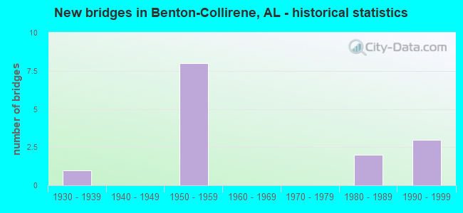
- New bridges - historical statistics
- 11930-1939
- 81950-1959
- 21980-1989
- 31990-1999

- Bridge Condition - Deck
- 33.3%Satisfactory
- 66.7%Fair

- Bridge Condition - Superstructure
- 33.3%Good
- 33.3%Satisfactory
- 33.3%Fair

- Bridge Condition - Substructure
- 66.7%Satisfactory
- 33.3%Fair

- Bridge Condition - Channel
- 64.3%Good
- 28.6%Satisfactory
- 7.1%Poor

- Bridge Condition - Culverts
- 18.2%Very good
- 72.7%Good
- 9.1%Satisfactory
Find on map >> Show street view
Structure Number: 1348, Location: 0.6 MI WEST OF JCT RT #17 (Lat: 33.444372, Lng: -88.005256), Route carried "on" structure: County highway 248, Year Built: 1935, Status: Open, Structure Length: 0.64m (2.10ft), Average Daily Traffic: 50 (year 1998), Average Future Daily Traffic: 75 (year 2028), Design Load: HS 20, Features Intersected: LITTLE LUBBUB CREEK, Facility Carried by Structure: COUNTY RT #208
Minimum Vertical Clearance: 30+ m (98+ ft), Kilometerpoint: 0.010, Lanes on structure: 2, Owner: County Highway Agency, Approaching Roadway Width: 7.9m (25.9ft), Material/Design: Concrete, Design/Construction: Culvert, Number Of Spans In Main Unit: 2, Length of Maximum Span: 3.0m (9.8ft), Curb-To-Curb Width: 7.3m (24.0ft), Out-to-Out Width: 7.9m (25.9ft)
Condition: Channel: Satisfactory, Culverts: Good, Operating Rating: 88.9 metric tons, Method Used To Determine Operating Rating: Load Factor (LF), Inventory Rating: 57.2 metric tons, Method Used To Determine Inventory Rating: Load Factor (LF), Structural Evaluation: Better than present minimum criteria, Deck Geometry: Equal to present minimum criteria, Waterway Adequacy: Somewhat better than minimum adequacy, Approach Roadway Alignment: Somewhat better than minimum adequacy, Length Of Structure Improvement: 1.26m (4.13ft), Designated Inspection Frequency: Every 24 months, Inspection Date: November 2021, Bridge Improvement Cost: $182,000, Roadway Improvement Cost: $18,000, Total Project Cost: $200,000 ( Estimate for 2022)
Find on map >> Show street view
Structure Number: 4261, Location: 2 MI N WEST OF CO 12 (Lat: 32.190878, Lng: -86.862350), Route carried "on" structure: County highway , Year Built: 1993, Status: Open, Structure Length: 1.01m (3.31ft), Average Daily Traffic: 60 (year 2003), Average Future Daily Traffic: 50 (year 2028), Design Load: HS 20, Features Intersected: CREEK, Facility Carried by Structure: HOLLINGSHEAD RD
Minimum Vertical Clearance: 30+ m (98+ ft), Kilometerpoint: 0.010, Lanes on structure: 2, Owner: County Highway Agency, Approaching Roadway Width: 8.5m (27.9ft), Material/Design: Concrete, Design/Construction: Culvert, Number Of Spans In Main Unit: 3, Length of Maximum Span: 3.0m (9.8ft)
Condition: Channel: Good, Culverts: Very good, Operating Rating: 88.9 metric tons, Method Used To Determine Operating Rating: Load Factor (LF), Inventory Rating: 71.3 metric tons, Method Used To Determine Inventory Rating: Load Factor (LF), Structural Evaluation: Equal to present desirable criteria, Waterway Adequacy: Better than present minimum criteria, Approach Roadway Alignment: Equal to present minimum criteria, Length Of Structure Improvement: 1.68m (5.51ft), Designated Inspection Frequency: Every 24 months, Inspection Date: Febuary 2021, Bridge Improvement Cost: $408,000, Roadway Improvement Cost: $41,000, Total Project Cost: $449,000 ( Estimate for 2022)
Find on map >> Show street view
Structure Number: 4851, Location: 2MI NORTH OF US 80 (Lat: 32.294217, Lng: -86.714569), Route carried "on" structure: County highway 23, Year Built: 1954, Status: Posted for load, Structure Length: 7.25m (23.79ft), Average Daily Traffic: 460 (year 2015), Truck Traffic: 5%, Average Future Daily Traffic: 600 (year 2035), Design Load: H 15, Features Intersected: UNNAMED CREEK
Minimum Vertical Clearance: 30+ m (98+ ft), Kilometerpoint: 0.010, Lanes on structure: 2, Owner: County Highway Agency, Approaching Roadway Width: 5.8m (19.0ft), Material/Design: Concrete, Design/Construction: Tee Beam, Number Of Spans In Main Unit: 7, Length of Maximum Span: 10.4m (34.1ft), Curb-To-Curb Width: 6.6m (21.7ft), Out-to-Out Width: 7.1m (23.3ft)
Condition: Deck: Fair, Superstructure: Satisfactory, Substructure: Satisfactory, Channel: Poor, Operating Rating: 35.7 metric tons, Method Used To Determine Operating Rating: Load Factor (LF), Inventory Rating: 21.4 metric tons, Method Used To Determine Inventory Rating: Load Factor (LF), Structural Evaluation: Equal to present minimum criteria, Deck Geometry: High priority of corrective action, Waterway Adequacy: Better than present minimum criteria, Approach Roadway Alignment: Better than present minimum criteria, Bridge Posting: Required (Relationship of Operating Rating to Maximum Legal Load: 0.1 - 9.9% below), Length Of Structure Improvement: 8.27m (27.13ft), Designated Inspection Frequency: Every 24 months, Other Special Inspection Frequency: Every 12 months, Inspection Date: April 2021, Other Special Inspection Date: April 2021, Bridge Improvement Cost: $1,305,000, Roadway Improvement Cost: $131,000, Total Project Cost: $1,436,000 ( Estimate for 2022), Deck Structure Type: Concrete Cast-file-Place
Find on map >> Show street view
Structure Number: 4852, Location: 4MI NORTH OF US HWY80 (Lat: 32.321814, Lng: -86.712544), Route carried "on" structure: County highway 20023, Year Built: 1954, Status: Posted for load, Structure Length: 23.29m (76.41ft), Average Daily Traffic: 460 (year 2015), Truck Traffic: 10%, Average Future Daily Traffic: 600 (year 2035), Design Load: H 15, Features Intersected: BIG SWAMP CREEK, Facility Carried by Structure: CO RD 23
Minimum Vertical Clearance: 30+ m (98+ ft), Kilometerpoint: 0.010, Lanes on structure: 2, Owner: County Highway Agency, Approaching Roadway Width: 8.5m (27.9ft), Material/Design: Concrete, Design/Construction: Tee Beam, Number Of Spans In Main Unit: 22, Length of Maximum Span: 15.2m (49.9ft), Curb-To-Curb Width: 6.6m (21.7ft), Out-to-Out Width: 7.1m (23.3ft)
Condition: Deck: Fair, Superstructure: Fair, Substructure: Fair, Channel: Good, Operating Rating: 35.7 metric tons, Method Used To Determine Operating Rating: Load Factor (LF), Inventory Rating: 21.4 metric tons, Method Used To Determine Inventory Rating: Load Factor (LF), Structural Evaluation: Somewhat better than minimum adequacy, Deck Geometry: High priority of corrective action, Waterway Adequacy: Equal to present minimum criteria, Approach Roadway Alignment: Better than present minimum criteria, Bridge Posting: Required (Relationship of Operating Rating to Maximum Legal Load: 0.1 - 9.9% below), Length Of Structure Improvement: 23.29m (76.41ft), Designated Inspection Frequency: Every 24 months, Other Special Inspection Frequency: Every 12 months, Inspection Date: April 2021, Other Special Inspection Date: April 2021, Bridge Improvement Cost: $3,673,000, Roadway Improvement Cost: $367,000, Total Project Cost: $4,040,000 ( Estimate for 2022), Deck Structure Type: Concrete Cast-file-Place
Find on map >> Show street view
Structure Number: 5493, Location: 7 MI SOUTH OF US 80 (Lat: 32.170758, Lng: -86.732414), Route carried "on" structure: County highway 17, Year Built: 1956, Status: Open, Structure Length: 0.67m (2.20ft), Average Daily Traffic: 450 (year 2003), Truck Traffic: 5%, Average Future Daily Traffic: 500 (year 2030), Design Load: H 15, Features Intersected: ASH CREEK
Minimum Vertical Clearance: 30+ m (98+ ft), Kilometerpoint: 0.010, Lanes on structure: 2, Owner: County Highway Agency, Approaching Roadway Width: 8.5m (27.9ft), Material/Design: Concrete, Design/Construction: Culvert, Number Of Spans In Main Unit: 2, Length of Maximum Span: 3.0m (9.8ft)
Condition: Channel: Good, Culverts: Good, Operating Rating: 73.9 metric tons, Method Used To Determine Operating Rating: Load Factor (LF), Inventory Rating: 44.4 metric tons, Method Used To Determine Inventory Rating: Load Factor (LF), Structural Evaluation: Better than present minimum criteria, Waterway Adequacy: Somewhat better than minimum adequacy, Approach Roadway Alignment: Better than present minimum criteria, Length Of Structure Improvement: 1.30m (4.27ft), Designated Inspection Frequency: Every 24 months, Inspection Date: Febuary 2021, Bridge Improvement Cost: $225,000, Roadway Improvement Cost: $23,000, Total Project Cost: $248,000 ( Estimate for 2022)
Find on map >> Show street view
Structure Number: 5494, Location: 5 MI SOUTH OF US 80 (Lat: 32.205947, Lng: -86.732758), Route carried "on" structure: County highway 17, Year Built: 1956, Status: Open, Structure Length: 1.65m (5.41ft), Average Daily Traffic: 430 (year 2003), Truck Traffic: 5%, Average Future Daily Traffic: 450 (year 2030), Design Load: H 15, Features Intersected: CREEK
Minimum Vertical Clearance: 30+ m (98+ ft), Kilometerpoint: 0.010, Lanes on structure: 2, Base Highway Network: Yes, Owner: County Highway Agency, Approaching Roadway Width: 7.3m (24.0ft), Material/Design: Concrete, Design/Construction: Culvert, Number Of Spans In Main Unit: 5, Length of Maximum Span: 3.0m (9.8ft)
Condition: Channel: Good, Culverts: Good, Operating Rating: 37.9 metric tons, Method Used To Determine Operating Rating: Load Factor (LF), Inventory Rating: 22.7 metric tons, Method Used To Determine Inventory Rating: Load Factor (LF), Structural Evaluation: Equal to present minimum criteria, Waterway Adequacy: Better than present minimum criteria, Approach Roadway Alignment: Equal to present desirable criteria, Length Of Structure Improvement: 2.34m (7.68ft), Designated Inspection Frequency: Every 24 months, Inspection Date: Febuary 2021, Bridge Improvement Cost: $405,000, Roadway Improvement Cost: $41,000, Total Project Cost: $446,000 ( Estimate for 2022)
Find on map >> Show street view
Structure Number: 5495, Location: 4 MI SOUTH OF US 80 (Lat: 32.207472, Lng: -86.733894), Route carried "on" structure: County highway 17, Year Built: 1956, Status: Open, Structure Length: 1.95m (6.40ft), Average Daily Traffic: 440 (year 2004), Truck Traffic: 5%, Average Future Daily Traffic: 480 (year 2028), Design Load: H 15, Features Intersected: CREEK
Minimum Vertical Clearance: 30+ m (98+ ft), Kilometerpoint: 0.010, Lanes on structure: 2, Base Highway Network: Yes, Owner: County Highway Agency, Approaching Roadway Width: 8.5m (27.9ft), Material/Design: Concrete, Design/Construction: Culvert, Number Of Spans In Main Unit: 5, Length of Maximum Span: 3.7m (12.1ft)
Condition: Channel: Satisfactory, Culverts: Satisfactory, Operating Rating: 40.5 metric tons, Method Used To Determine Operating Rating: Load Factor (LF), Inventory Rating: 33.3 metric tons, Method Used To Determine Inventory Rating: Load Factor (LF), Structural Evaluation: Equal to present minimum criteria, Waterway Adequacy: Better than present minimum criteria, Approach Roadway Alignment: Equal to present minimum criteria, Length Of Structure Improvement: 2.69m (8.83ft), Designated Inspection Frequency: Every 24 months, Inspection Date: Febuary 2021, Bridge Improvement Cost: $466,000, Roadway Improvement Cost: $47,000, Total Project Cost: $513,000 ( Estimate for 2022)
Find on map >> Show street view
Structure Number: 5496, Location: 3 MI SOUTH OF US 80 (Lat: 32.209364, Lng: -86.735253), Route carried "on" structure: County highway 17, Year Built: 1956, Status: Open, Structure Length: 1.65m (5.41ft), Average Daily Traffic: 415 (year 2003), Truck Traffic: 5%, Average Future Daily Traffic: 480 (year 2030), Design Load: H 15, Features Intersected: CREEK
Minimum Vertical Clearance: 30+ m (98+ ft), Kilometerpoint: 0.010, Lanes on structure: 2, Base Highway Network: Yes, Owner: County Highway Agency, Approaching Roadway Width: 8.5m (27.9ft), Material/Design: Concrete, Design/Construction: Culvert, Number Of Spans In Main Unit: 5, Length of Maximum Span: 3.0m (9.8ft)
Condition: Channel: Good, Culverts: Good, Operating Rating: 39.9 metric tons, Method Used To Determine Operating Rating: Load Factor (LF), Inventory Rating: 23.9 metric tons, Method Used To Determine Inventory Rating: Load Factor (LF), Structural Evaluation: Equal to present minimum criteria, Waterway Adequacy: Better than present minimum criteria, Approach Roadway Alignment: Better than present minimum criteria, Length Of Structure Improvement: 2.34m (7.68ft), Designated Inspection Frequency: Every 24 months, Inspection Date: Febuary 2021, Bridge Improvement Cost: $405,000, Roadway Improvement Cost: $41,000, Total Project Cost: $446,000 ( Estimate for 2022)
Find on map >> Show street view
Structure Number: 5497, Location: 3MI SOUTH OF US HWY80 (Lat: 32.204094, Lng: -86.741842), Route carried "on" structure: County highway 17, Year Built: 1956, Status: Open, Structure Length: 0.79m (2.59ft), Average Daily Traffic: 415 (year 2003), Truck Traffic: 5%, Average Future Daily Traffic: 480 (year 2030), Design Load: H 15, Features Intersected: CREEK
Minimum Vertical Clearance: 30+ m (98+ ft), Kilometerpoint: 0.010, Lanes on structure: 2, Base Highway Network: Yes, Owner: County Highway Agency, Approaching Roadway Width: 8.5m (27.9ft), Material/Design: Concrete, Design/Construction: Culvert, Number Of Spans In Main Unit: 2, Length of Maximum Span: 3.7m (12.1ft)
Condition: Channel: Good, Culverts: Good, Operating Rating: 85.5 metric tons, Method Used To Determine Operating Rating: Load Factor (LF), Inventory Rating: 51.3 metric tons, Method Used To Determine Inventory Rating: Load Factor (LF), Structural Evaluation: Better than present minimum criteria, Waterway Adequacy: Equal to present minimum criteria, Approach Roadway Alignment: Better than present minimum criteria, Length Of Structure Improvement: 1.44m (4.72ft), Designated Inspection Frequency: Every 24 months, Inspection Date: Febuary 2021, Bridge Improvement Cost: $250,000, Roadway Improvement Cost: $25,000, Total Project Cost: $275,000 ( Estimate for 2022)
Find on map >> Show street view
Structure Number: 55, Location: 1 MI SOUTH OF US 80 (Lat: 32.251342, Lng: -86.754869), Route carried "on" structure: County highway 17, Year Built: 1956, Status: Open, Structure Length: 0.67m (2.20ft), Average Daily Traffic: 415 (year 2003), Truck Traffic: 5%, Average Future Daily Traffic: 450 (year 2030), Design Load: H 15, Features Intersected: BUCK CREEK
Minimum Vertical Clearance: 30+ m (98+ ft), Kilometerpoint: 0.010, Lanes on structure: 2, Base Highway Network: Yes, Owner: County Highway Agency, Approaching Roadway Width: 8.5m (27.9ft), Material/Design: Concrete, Design/Construction: Culvert, Number Of Spans In Main Unit: 2, Length of Maximum Span: 3.0m (9.8ft)
Condition: Channel: Good, Culverts: Good, Operating Rating: 47.2 metric tons, Method Used To Determine Operating Rating: Load Factor (LF), Inventory Rating: 28.3 metric tons, Method Used To Determine Inventory Rating: Load Factor (LF), Structural Evaluation: Better than present minimum criteria, Waterway Adequacy: Equal to present minimum criteria, Approach Roadway Alignment: Better than present minimum criteria, Length Of Structure Improvement: 1.30m (4.27ft), Designated Inspection Frequency: Every 24 months, Inspection Date: Febuary 2021, Bridge Improvement Cost: $225,000, Roadway Improvement Cost: $23,000, Total Project Cost: $248,000 ( Estimate for 2022)
Find on map >> Show street view
Structure Number: 1348, Location: 1.5 MI NORTH OF CO RD 12 (Lat: 32.178103, Lng: -86.784756), Route carried "on" structure: County highway , Year Built: 1985, Status: Open, Structure Length: 1.16m (3.81ft), Average Daily Traffic: 130 (year 2003), Truck Traffic: 5%, Average Future Daily Traffic: 160 (year 2028), Design Load: H 15, Features Intersected: PANTHER CREEK, Facility Carried by Structure: COLLIRENE CUTOFFR
Minimum Vertical Clearance: 30+ m (98+ ft), Kilometerpoint: 0.010, Lanes on structure: 2, Owner: County Highway Agency, Approaching Roadway Width: 8.5m (27.9ft), Material/Design: Concrete, Design/Construction: Culvert, Number Of Spans In Main Unit: 3, Length of Maximum Span: 3.7m (12.1ft), Curb-To-Curb Width: 11.6m (38.1ft), Out-to-Out Width: 12.2m (40.0ft)
Condition: Channel: Good, Culverts: Good, Operating Rating: 88.9 metric tons, Method Used To Determine Operating Rating: Load Factor (LF), Inventory Rating: 63.4 metric tons, Method Used To Determine Inventory Rating: Load Factor (LF), Structural Evaluation: Better than present minimum criteria, Deck Geometry: Superior to present desirable criteria, Waterway Adequacy: Equal to present minimum criteria, Approach Roadway Alignment: Equal to present minimum criteria, Length Of Structure Improvement: 1.84m (6.04ft), Designated Inspection Frequency: Every 24 months, Inspection Date: Febuary 2021, Bridge Improvement Cost: $424,000, Roadway Improvement Cost: $42,000, Total Project Cost: $466,000 ( Estimate for 2022)
Find on map >> Show street view
Structure Number: 14095, Location: 1.5 MI NORTH OF CO RD 12 (Lat: 32.194797, Lng: -86.841742), Route carried "on" structure: County highway , Year Built: 1987, Status: Open, Structure Length: 0.67m (2.20ft), Average Daily Traffic: 95 (year 2003), Average Future Daily Traffic: 110 (year 2028), Design Load: HS 20, Features Intersected: CREEK, Facility Carried by Structure: OLD TOWN RD
Minimum Vertical Clearance: 30+ m (98+ ft), Kilometerpoint: 0.010, Lanes on structure: 2, Owner: County Highway Agency, Approaching Roadway Width: 8.5m (27.9ft), Material/Design: Concrete, Design/Construction: Culvert, Number Of Spans In Main Unit: 2, Length of Maximum Span: 3.0m (9.8ft)
Condition: Channel: Satisfactory, Culverts: Very good, Operating Rating: 75.8 metric tons, Method Used To Determine Operating Rating: Load Factor (LF), Inventory Rating: 45.4 metric tons, Method Used To Determine Inventory Rating: Load Factor (LF), Structural Evaluation: Equal to present desirable criteria, Waterway Adequacy: Equal to present minimum criteria, Approach Roadway Alignment: Somewhat better than minimum adequacy, Length Of Structure Improvement: 1.30m (4.27ft), Designated Inspection Frequency: Every 24 months, Inspection Date: Febuary 2021, Bridge Improvement Cost: $315,000, Roadway Improvement Cost: $32,000, Total Project Cost: $347,000 ( Estimate for 2022)
Find on map >> Show street view
Structure Number: 16231, Location: 5 MI WEST OF CO RD 23 (Lat: 32.300722, Lng: -86.793750), Route carried "on" structure: County highway , Year Built: 1995, Status: Open, Structure Length: 7.92m (25.98ft), Average Daily Traffic: 310 (year 2015), Truck Traffic: 5%, Average Future Daily Traffic: 420 (year 2035), Design Load: HS 20, Features Intersected: BIG SWAMP CREEK, Facility Carried by Structure: BENTON ROAD
Minimum Vertical Clearance: 30+ m (98+ ft), Kilometerpoint: 0.010, Lanes on structure: 2, Base Highway Network: Yes, Owner: County Highway Agency, Approaching Roadway Width: 6.1m (20.0ft), Material/Design: Prestressed concrete, Design/Construction: Stringer/Multi-beam, Number Of Spans In Main Unit: 4, Length of Maximum Span: 33.4m (109.6ft), Curb-To-Curb Width: 8.5m (27.9ft), Out-to-Out Width: 9.4m (30.8ft)
Condition: Deck: Satisfactory, Superstructure: Good, Substructure: Satisfactory, Channel: Satisfactory, Operating Rating: 58.2 metric tons, Method Used To Determine Operating Rating: Load Factor (LF), Inventory Rating: 42.7 metric tons, Method Used To Determine Inventory Rating: Load Factor (LF), Structural Evaluation: Equal to present minimum criteria, Deck Geometry: Equal to present minimum criteria, Waterway Adequacy: Equal to present minimum criteria, Approach Roadway Alignment: Somewhat better than minimum adequacy, Length Of Structure Improvement: 8.93m (29.30ft), Designated Inspection Frequency: Every 24 months, Inspection Date: April 2021, Bridge Improvement Cost: $1,837,000, Roadway Improvement Cost: $184,000, Total Project Cost: $2,021,000 ( Estimate for 2022), Deck Structure Type: Concrete Cast-file-Place
Find on map >> Show street view
Structure Number: 16704, Location: 7MI W OF CO RD 23 (Lat: 32.298539, Lng: -86.806814), Route carried "on" structure: County highway 40, Year Built: 1996, Status: Open, Structure Length: 0.67m (2.20ft), Average Daily Traffic: 300 (year 2003), Truck Traffic: 9%, Average Future Daily Traffic: 500 (year 2031), Design Load: HS 20, Features Intersected: CREEK
Minimum Vertical Clearance: 30+ m (98+ ft), Kilometerpoint: 0.010, Lanes on structure: 2, Base Highway Network: Yes, Owner: County Highway Agency, Approaching Roadway Width: 8.5m (27.9ft), Material/Design: Concrete, Design/Construction: Culvert, Number Of Spans In Main Unit: 2, Length of Maximum Span: 3.0m (9.8ft)
Condition: Channel: Good, Culverts: Good, Operating Rating: 61.9 metric tons, Method Used To Determine Operating Rating: Load Factor (LF), Inventory Rating: 37.1 metric tons, Method Used To Determine Inventory Rating: Load Factor (LF), Structural Evaluation: Better than present minimum criteria, Waterway Adequacy: Equal to present minimum criteria, Approach Roadway Alignment: Better than present minimum criteria, Length Of Structure Improvement: 1.30m (4.27ft), Designated Inspection Frequency: Every 24 months, Inspection Date: Febuary 2021, Bridge Improvement Cost: $315,000, Roadway Improvement Cost: $32,000, Total Project Cost: $347,000 ( Estimate for 2022)