Bridge Statistics for Benton, Louisiana (LA)
Condition, Traffic, Stress, Structural Evaluation, Project Costs
- National Bridge Inventory (NBI) Statistics
- 11Number of bridges
- 308ft / 94.2mTotal length
- $1,582,000Total costs
- 40,062Total average daily traffic
- 3,185Total average daily truck traffic
- 14,448Total future (year 2036) average daily traffic
- National Bridge Inventory (NBI) Registered Bridges for Benton
- No street view available for this location
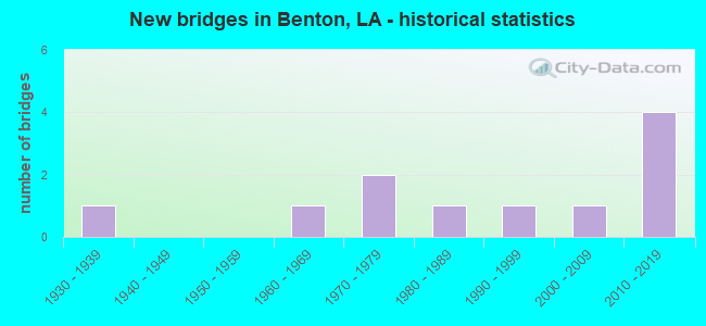
- New bridges - historical statistics
- 11930-1939
- 11960-1969
- 21970-1979
- 11980-1989
- 11990-1999
- 12000-2009
- 42010-2019


- Bridge Condition - Deck
- 40.0%Very good
- 20.0%Good
- 10.0%Satisfactory
- 10.0%Serious
- 20.0%Failed

- Bridge Condition - Superstructure
- 50.0%Very good
- 10.0%Good
- 10.0%Satisfactory
- 10.0%Serious
- 20.0%Failed

- Bridge Condition - Substructure
- 20.0%Very good
- 20.0%Good
- 30.0%Satisfactory
- 10.0%Serious
- 20.0%Failed

- Bridge Condition - Channel
- 30.0%Very good
- 40.0%Good
- 20.0%Satisfactory
- 10.0%Failed
Find on map >> Show street view
Structure Number: 40800000040411, Location: 0.95 MI. NORTH OF LA 162 (Lat: 32.711111, Lng: -93.736661), Route carried "on" structure: State highway 3, Year Built: 2015, Status: Open, Structure Length: 45.32m (148.69ft), Average Daily Traffic: 5,200 (year 2016), Truck Traffic: 26%, Average Future Daily Traffic: 4,020 (year 2036), Design Load: HL 93, Features Intersected: UNION PACIFIC RAILROAD
Minimum Vertical Clearance: 30+ m (98+ ft), Kilometerpoint: 1.392, Lanes on structure: 2, Base Highway Network: Yes (Inventory Route: 44-02-1, Subroute: 10), Owner: State Highway Agency, Approaching Roadway Width: 12.2m (40.0ft), Skew: 33 degrees, Material/Design: Steel continuous, Design/Construction: Girder and Floorbeam System, Number Of Spans In Main Unit: 14, Length of Maximum Span: 48.8m (160.1ft), Curb-To-Curb Width: 12.1m (39.7ft), Out-to-Out Width: 13.2m (43.3ft)
Condition: Deck: Very good, Superstructure: Very good, Substructure: Very good, Operating Rating: 41.8 metric tons, Method Used To Determine Operating Rating: Load and Resistance Factor Rating (LRFR) rating reported by rating factor(RF) method using HL-93 loadings, Inventory Rating: 32.4 metric tons, Method Used To Determine Inventory Rating: Load and Resistance Factor Rating (LRFR) rating reported by rating factor(RF) method using HL-93 loadings, Structural Evaluation: Equal to present desirable criteria, Deck Geometry: Somewhat better than minimum adequacy, Underclear: Superior to present desirable criteria, Approach Roadway Alignment: Equal to present minimum criteria, Designated Inspection Frequency: Every 24 months, Inspection Date: November 2020, Deck Structure Type: Concrete Cast-file-Place, Wearing Surface/Protective System: Wearing Surface: Monolithic Concrete
Find on map >> Show street view
Structure Number: 40800000040422, Location: 1.0 MI. N. OF LA 162 (Lat: 32.707739, Lng: -93.733539), Route carried "on" structure: County highway , Year Built: 2016, Status: Open, Structure Length: 2.80m (9.19ft), Average Daily Traffic: 12 (year 2020), Design Load: H 10, Features Intersected: Black Bayou, Facility Carried by Structure: Sibley Rd
Minimum Vertical Clearance: 30+ m (98+ ft), Kilometerpoint: 0.000, Lanes on structure: 2, Owner: County Highway Agency, Approaching Roadway Width: 6.4m (21.0ft), Skew: 30 degrees, Material/Design: Wood or Timber, Design/Construction: Stringer/Multi-beam, Number Of Spans In Main Unit: 6, Length of Maximum Span: 4.9m (16.1ft), Curb-To-Curb Width: 7.6m (24.9ft), Out-to-Out Width: 8.0m (26.2ft)
Condition: Deck: Very good, Superstructure: Very good, Substructure: Very good, Channel: Good, Operating Rating: 34.5 metric tons, Method Used To Determine Operating Rating: Allowable Stress (AS), Inventory Rating: 25.4 metric tons, Method Used To Determine Inventory Rating: Allowable Stress (AS), Structural Evaluation: Equal to present minimum criteria, Deck Geometry: Equal to present minimum criteria, Waterway Adequacy: Equal to present desirable criteria, Approach Roadway Alignment: Equal to present desirable criteria, Designated Inspection Frequency: Every 24 months, Inspection Date: December 2020, Deck Structure Type: Other
Find on map >> Show street view
Structure Number: 40800000300459, Location: 2.7 MILES SOUTH OF LA HIG (Lat: 32.678819, Lng: -93.636481), Route carried "on" structure: County highway , Year Built: 2009, Status: Open, Structure Length: 1.83m (6.00ft), Average Daily Traffic: 1,200 (year 2020), Average Future Daily Traffic: 600 (year 2036), Design Load: HS 20, Features Intersected: White Oak Branch, Facility Carried by Structure: Crouch Rd
Minimum Vertical Clearance: 30+ m (98+ ft), Kilometerpoint: 0.000, Lanes on structure: 2, Owner: County Highway Agency, Approaching Roadway Width: 6.1m (20.0ft), Skew: 33 degrees, Material/Design: Concrete, Design/Construction: Slab, Number Of Spans In Main Unit: 3, Length of Maximum Span: 6.1m (20.0ft), Curb-To-Curb Width: 8.4m (27.6ft), Out-to-Out Width: 9.1m (29.9ft)
Condition: Deck: Good, Superstructure: Good, Substructure: Good, Channel: Very good, Operating Rating: 56.4 metric tons, Method Used To Determine Operating Rating: Load and Resistance Factor Rating (LRFR) rating reported by rating factor(RF) method using HL-93 loadings, Inventory Rating: 43.4 metric tons, Method Used To Determine Inventory Rating: Load and Resistance Factor Rating (LRFR) rating reported by rating factor(RF) method using HL-93 loadings, Structural Evaluation: Better than present minimum criteria, Deck Geometry: Meets minimum limits, Waterway Adequacy: Equal to present desirable criteria, Approach Roadway Alignment: Equal to present desirable criteria, Designated Inspection Frequency: Every 24 months, Inspection Date: December 2020, Deck Structure Type: Concrete Precast Panels, Wearing Surface/Protective System: Wearing Surface: Bituminous
Find on map >> Show street view
Structure Number: 40800000300462, Location: 4.5 MI W OF LA 157 (Lat: 32.675119, Lng: -93.616950), Route carried "on" structure: County highway , Year Built: 2013, Status: Open, Structure Length: 1.95m (6.40ft), Average Daily Traffic: 220 (year 2020), Truck Traffic: 5%, Average Future Daily Traffic: 132 (year 2036), Design Load: H 20, Features Intersected: Bodcau Bayou Trib, Facility Carried by Structure: Linton-Bellevue Rd
Minimum Vertical Clearance: 30+ m (98+ ft), Kilometerpoint: 0.000, Lanes on structure: 2, Owner: County Highway Agency, Approaching Roadway Width: 5.5m (18.0ft), Skew: 30 degrees, Material/Design: Wood or Timber, Design/Construction: Stringer/Multi-beam, Number Of Spans In Main Unit: 4, Length of Maximum Span: 4.9m (16.1ft), Curb-To-Curb Width: 7.5m (24.6ft), Out-to-Out Width: 8.0m (26.2ft)
Condition: Deck: Very good, Superstructure: Very good, Substructure: Satisfactory, Channel: Very good, Operating Rating: 29.0 metric tons, Method Used To Determine Operating Rating: Allowable Stress (AS), Inventory Rating: 20.9 metric tons, Method Used To Determine Inventory Rating: Allowable Stress (AS), Structural Evaluation: Equal to present minimum criteria, Deck Geometry: Somewhat better than minimum adequacy, Waterway Adequacy: Equal to present minimum criteria, Approach Roadway Alignment: Equal to present desirable criteria, Designated Inspection Frequency: Every 24 months, Inspection Date: December 2020, Deck Structure Type: Open Grating, Wearing Surface/Protective System: Wearing Surface: Bituminous
Find on map >> Show street view
Structure Number: 4080000030052, Location: 1.2 MI. WEST OF CROUCH RD (Lat: 32.652711, Lng: -93.653711), Route carried "on" structure: County highway , Year Built: 2010, Status: Open, Structure Length: 13.72m (45.01ft), Average Daily Traffic: 2,750 (year 2020), Average Future Daily Traffic: 1,650 (year 2036), Design Load: HS 20, Features Intersected: Cypress Bayou, Facility Carried by Structure: Parks Rd
Minimum Vertical Clearance: 30+ m (98+ ft), Kilometerpoint: 0.000, Lanes on structure: 2, Owner: County Highway Agency, Approaching Roadway Width: 7.3m (24.0ft), Skew: 30 degrees, Material/Design: Prestressed concrete, Design/Construction: Stringer/Multi-beam, Number Of Spans In Main Unit: 9, Length of Maximum Span: 15.2m (49.9ft), Curb-To-Curb Width: 12.0m (39.4ft), Out-to-Out Width: 12.9m (42.3ft)
Condition: Deck: Very good, Superstructure: Very good, Substructure: Good, Channel: Good, Operating Rating: 37.9 metric tons, Method Used To Determine Operating Rating: Load and Resistance Factor Rating (LRFR) rating reported by rating factor(RF) method using HL-93 loadings, Inventory Rating: 20.4 metric tons, Method Used To Determine Inventory Rating: Load and Resistance Factor Rating (LRFR) rating reported by rating factor(RF) method using HL-93 loadings, Structural Evaluation: Somewhat better than minimum adequacy, Deck Geometry: Somewhat better than minimum adequacy, Waterway Adequacy: Equal to present desirable criteria, Approach Roadway Alignment: Equal to present minimum criteria, Designated Inspection Frequency: Every 24 months, Underwater Inspection Frequency: Every 60 months, Inspection Date: December 2020, Underwater Inspection Date: January 2021, Deck Structure Type: Concrete Cast-file-Place, Wearing Surface/Protective System: Wearing Surface: Monolithic Concrete
Find on map >> Show street view
Structure Number: 40800440201311, Location: 1.31 MI NORTH OF LA 162 (Lat: 32.715739, Lng: -93.738800), Route carried "on" structure: State highway 3, Year Built: 1934, Status: Open, Structure Length: 0.82m (2.69ft), Average Daily Traffic: 5,200 (year 2016), Truck Traffic: 26%, Average Future Daily Traffic: 4,020 (year 2036), Design Load: H 15, Features Intersected: BLACK BAYOU
Minimum Vertical Clearance: 30+ m (98+ ft), Kilometerpoint: 2.089, Lanes on structure: 2, Base Highway Network: Yes (Inventory Route: 44-02-1, Subroute: 10), Owner: State Highway Agency, Approaching Roadway Width: 12.5m (41.0ft), Material/Design: Concrete, Design/Construction: Culvert, Number Of Spans In Main Unit: 4, Length of Maximum Span: 1.8m (5.9ft), Curb-To-Curb Width: 12.5m (41.0ft), Out-to-Out Width: 15.2m (49.9ft)
Condition: Channel: Good, Culverts: Satisfactory, Operating Rating: 42.1 metric tons, Method Used To Determine Operating Rating: Load and Resistance Factor Rating (LRFR) rating reported by rating factor(RF) method using HL-93 loadings, Inventory Rating: 32.4 metric tons, Method Used To Determine Inventory Rating: Load and Resistance Factor Rating (LRFR) rating reported by rating factor(RF) method using HL-93 loadings, Structural Evaluation: Equal to present minimum criteria, Deck Geometry: Somewhat better than minimum adequacy, Waterway Adequacy: Better than present minimum criteria, Approach Roadway Alignment: Equal to present desirable criteria, Designated Inspection Frequency: Every 24 months, Inspection Date: November 2020, Deck Structure Type: Concrete Cast-file-Place
Find on map >> Show street view
Structure Number: 40800823000761, Location: 00.76 MI EAST OF LA 3 (Lat: 32.695311, Lng: -93.728500), Route carried "on" structure: State highway 162, Year Built: 1967, Status: Posted for load, Structure Length: 5.88m (19.29ft), Average Daily Traffic: 1,240 (year 2016), Truck Traffic: 19%, Average Future Daily Traffic: 822 (year 2036), Design Load: H 15, Features Intersected: BLACK BAYOU
Minimum Vertical Clearance: 30+ m (98+ ft), Kilometerpoint: 1.218, Lanes on structure: 2, Owner: State Highway Agency, Approaching Roadway Width: 7.9m (25.9ft), Material/Design: Concrete, Design/Construction: Slab, Number Of Spans In Main Unit: 10, Length of Maximum Span: 5.8m (19.0ft), Curb-To-Curb Width: 7.5m (24.6ft), Out-to-Out Width: 8.2m (26.9ft)
Condition: Deck: Serious, Superstructure: Serious, Substructure: Serious, Channel: Satisfactory, Operating Rating: 15.9 metric tons, Method Used To Determine Operating Rating: Load and Resistance Factor Rating (LRFR) rating reported by rating factor(RF) method using HL-93 loadings, Inventory Rating: 12.3 metric tons, Method Used To Determine Inventory Rating: Load and Resistance Factor Rating (LRFR) rating reported by rating factor(RF) method using HL-93 loadings, Structural Evaluation: High priority of replacement, Deck Geometry: Meets minimum limits, Waterway Adequacy: Meets minimum limits, Approach Roadway Alignment: Equal to present desirable criteria, Bridge Posting: Required (Relationship of Operating Rating to Maximum Legal Load: 30.0 - 39.9% below), Length Of Structure Improvement: 6.80m (22.31ft), Designated Inspection Frequency: Every 24 months, Other Special Inspection Frequency: Every 12 months, Inspection Date: November 2021, Other Special Inspection Date: November 2020, Bridge Improvement Cost: $579,000, Total Project Cost: $868,000 ( Estimate for 2016), Deck Structure Type: Concrete Precast Panels, Wearing Surface/Protective System: Wearing Surface: Bituminous
Find on map >> Show street view
Structure Number: 40800823003261, Location: 3.26 MI EAST OF LA 3 (Lat: 32.706731, Lng: -93.689200), Route carried "on" structure: State highway 162, Year Built: 1973, Status: Open, Structure Length: 9.69m (31.79ft), Average Daily Traffic: 1,240 (year 2016), Truck Traffic: 19%, Average Future Daily Traffic: 822 (year 2036), Design Load: HS 20, Features Intersected: CYPRESS BAYOU
Minimum Vertical Clearance: 30+ m (98+ ft), Kilometerpoint: 5.229, Lanes on structure: 2, Owner: State Highway Agency, Approaching Roadway Width: 12.2m (40.0ft), Material/Design: Prestressed concrete, Design/Construction: Stringer/Multi-beam, Number Of Spans In Main Unit: 7, Length of Maximum Span: 13.7m (44.9ft), Curb-To-Curb Width: 12.3m (40.4ft), Out-to-Out Width: 13.2m (43.3ft)
Condition: Deck: Good, Superstructure: Very good, Substructure: Satisfactory, Channel: Good, Operating Rating: 77.1 metric tons, Method Used To Determine Operating Rating: Load Factor (LF), Inventory Rating: 39.9 metric tons, Method Used To Determine Inventory Rating: Load Factor (LF), Structural Evaluation: Equal to present minimum criteria, Deck Geometry: Better than present minimum criteria, Waterway Adequacy: Equal to present desirable criteria, Approach Roadway Alignment: Equal to present desirable criteria, Designated Inspection Frequency: Every 24 months, Underwater Inspection Frequency: Every 60 months, Inspection Date: November 2021, Underwater Inspection Date: March 2021, Deck Structure Type: Concrete Cast-file-Place
Find on map >> Show street view
Structure Number: 40832383934251, Location: 5.6M SOUTH OF LA 162 (Lat: 32.638600, Lng: -93.708119), Route carried "on" structure: County highway , Year Built: 1992, Status: Closed, Structure Length: 2.90m (9.51ft), Average Daily Traffic: 6,500 (year 2020), Average Future Daily Traffic: 846 (year 2036), Design Load: HS 20, Features Intersected: Flat River Bayou, Facility Carried by Structure: Linton Rd
Minimum Vertical Clearance: 30+ m (98+ ft), Kilometerpoint: 0.000, Lanes on structure: 2, Owner: County Highway Agency, Approaching Roadway Width: 9.8m (32.2ft), Material/Design: Concrete, Design/Construction: Slab, Number Of Spans In Main Unit: 5, Length of Maximum Span: 5.8m (19.0ft), Curb-To-Curb Width: 8.5m (27.9ft), Out-to-Out Width: 9.5m (31.2ft)
Condition: Deck: Failed, Superstructure: Failed, Substructure: Failed, Channel: Satisfactory, Waterway Adequacy: Equal to present desirable criteria, Approach Roadway Alignment: Equal to present minimum criteria, Bridge Posting: Required (Relationship of Operating Rating to Maximum Legal Load: > 39.9% below), Designated Inspection Frequency: Every 24 months, Other Special Inspection Frequency: Every 6 months, Inspection Date: December 2020, Other Special Inspection Date: December 2021, Deck Structure Type: Concrete Precast Panels
Find on map >> Show street view
Structure Number: 40832388934281, Location: 5.0 MI NORTH OF LA 3105 (Lat: 32.647031, Lng: -93.712969), Route carried "on" structure: County highway , Year Built: 1985, Year Reconstructed: 2012, Status: Open, Structure Length: 2.32m (7.61ft), Average Daily Traffic: 10,000 (year 2020), Average Future Daily Traffic: 996 (year 2036), Design Load: HS 20, Features Intersected: Flat River, Facility Carried by Structure: Airline Dr
Minimum Vertical Clearance: 30+ m (98+ ft), Kilometerpoint: 0.000, Lanes on structure: 3, Owner: County Highway Agency, Approaching Roadway Width: 11.6m (38.1ft), Skew: 33 degrees, Material/Design: Concrete, Design/Construction: Slab, Number Of Spans In Main Unit: 4, Length of Maximum Span: 5.8m (19.0ft), Curb-To-Curb Width: 12.7m (41.7ft), Out-to-Out Width: 13.7m (44.9ft)
Condition: Deck: Satisfactory, Superstructure: Satisfactory, Substructure: Satisfactory, Channel: Very good, Operating Rating: 60.6 metric tons, Method Used To Determine Operating Rating: Load and Resistance Factor Rating (LRFR) rating reported by rating factor(RF) method using HL-93 loadings, Inventory Rating: 46.7 metric tons, Method Used To Determine Inventory Rating: Load and Resistance Factor Rating (LRFR) rating reported by rating factor(RF) method using HL-93 loadings, Structural Evaluation: Equal to present minimum criteria, Deck Geometry: Meets minimum limits, Waterway Adequacy: Equal to present desirable criteria, Approach Roadway Alignment: Equal to present desirable criteria, Designated Inspection Frequency: Every 24 months, Inspection Date: December 2020, Deck Structure Type: Concrete Cast-file-Place, Wearing Surface/Protective System: Wearing Surface: Bituminous
Find on map >> Show street view
Structure Number: 40832389934161, Location: 3.0 MI W OF LA HWY 3 (Lat: 32.648211, Lng: -93.693311), Route carried "on" structure: County highway , Year Built: 1978, Status: Closed, Structure Length: 6.98m (22.90ft), Average Daily Traffic: 6,500 (year 2020), Average Future Daily Traffic: 540 (year 2036), Design Load: HS 20, Features Intersected: Black Bayou Reser, Facility Carried by Structure: Linton Rd
Minimum Vertical Clearance: 30+ m (98+ ft), Kilometerpoint: 0.000, Lanes on structure: 2, Owner: County Highway Agency, Approaching Roadway Width: 10.4m (34.1ft), Material/Design: Concrete, Design/Construction: Slab, Number Of Spans In Main Unit: 12, Length of Maximum Span: 5.8m (19.0ft), Curb-To-Curb Width: 8.6m (28.2ft), Out-to-Out Width: 9.5m (31.2ft)
Condition: Deck: Failed, Superstructure: Failed, Substructure: Failed, Channel: Failed, Deck Geometry: Meets minimum limits, Bridge Posting: Required (Relationship of Operating Rating to Maximum Legal Load: > 39.9% below), Length Of Structure Improvement: 7.89m (25.89ft), Designated Inspection Frequency: Every 24 months, Underwater Inspection Frequency: Every 60 months, Other Special Inspection Frequency: Every 6 months, Inspection Date: December 2020, Underwater Inspection Date: June 2021, Other Special Inspection Date: December 2021, Bridge Improvement Cost: $476,000, Total Project Cost: $714,000 ( Estimate for 2016), Deck Structure Type: Concrete Precast Panels, Wearing Surface/Protective System: Wearing Surface: Other