Bridge Statistics for Benton, Missouri (MO)
Condition, Traffic, Stress, Structural Evaluation, Project Costs
- National Bridge Inventory (NBI) Statistics
- 15Number of bridges
- 108ft / 32.8mTotal length
- $679,000Total costs
- 58,605Total average daily traffic
- 13,735Total average daily truck traffic
- National Bridge Inventory (NBI) Registered Bridges for Benton
- No street view available for this location
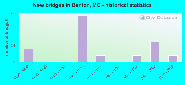
- New bridges - historical statistics
- 21930-1939
- 71960-1969
- 11970-1979
- 11990-1999
- 32000-2009
- 12010-2019


- Bridge Condition - Deck
- 11.1%Very good
- 55.6%Good
- 33.3%Satisfactory

- Bridge Condition - Superstructure
- 11.1%Excellent
- 44.4%Good
- 33.3%Satisfactory
- 11.1%Fair

- Bridge Condition - Substructure
- 11.1%Excellent
- 22.2%Very good
- 44.4%Good
- 11.1%Satisfactory
- 11.1%Fair

- Bridge Condition - Channel
- 11.1%Very good
- 66.7%Good
- 22.2%Satisfactory

- Bridge Condition - Culverts
- 50.0%Good
- 50.0%Satisfactory
Find on map >> Show street view
Structure Number: 13919, Location: S 10 T 28 N R 14 E (Lat: 37.105375, Lng: -89.492417), Route carried "on" structure: County highway 51, Year Built: 1960, Year Reconstructed: 1988, Status: Open, Structure Length: 2.62m (8.60ft), Average Daily Traffic: 20 (year 2021), Truck Traffic: 10%, Average Future Daily Traffic: 28 (year 2041), Features Intersected: NORTH CUT DTCH, Facility Carried by Structure: COUNTY RD 332
Minimum Vertical Clearance: 30+ m (98+ ft), Kilometerpoint: 4.989, Lanes on structure: 2, Owner: County Highway Agency, Approaching Roadway Width: 7.3m (24.0ft), Material/Design: Concrete, Design/Construction: Slab, Number Of Spans In Main Unit: 3, Length of Maximum Span: 10.7m (35.1ft), Curb-To-Curb Width: 7.3m (24.0ft), Out-to-Out Width: 7.3m (24.0ft)
Condition: Deck: Satisfactory, Superstructure: Satisfactory, Substructure: Good, Channel: Good, Operating Rating: 49.5 metric tons, Method Used To Determine Operating Rating: Allowable Stress (AS), Inventory Rating: 32.4 metric tons, Method Used To Determine Inventory Rating: Allowable Stress (AS), Structural Evaluation: Equal to present minimum criteria, Deck Geometry: Equal to present minimum criteria, Waterway Adequacy: Equal to present minimum criteria, Approach Roadway Alignment: Better than present minimum criteria, Designated Inspection Frequency: Every 24 months, Inspection Date: January 2021, Deck Structure Type: Concrete Cast-file-Place, Wearing Surface/Protective System: Wearing Surface: Bituminous
Find on map >> Show street view
Structure Number: 17801, Location: S 15 T 28 N R 13 E (Lat: 37.093694, Lng: -89.601800), Route carried "on" structure: County highway 163, Year Built: 1996, Status: Open, Structure Length: 1.28m (4.20ft), Average Daily Traffic: 150 (year 2021), Truck Traffic: 10%, Average Future Daily Traffic: 210 (year 2041), Features Intersected: BR CANEY CR, Facility Carried by Structure: COUNTY RD 250
Minimum Vertical Clearance: 30+ m (98+ ft), Kilometerpoint: 0.966, Lanes on structure: 1, Owner: County Highway Agency, Approaching Roadway Width: 6.1m (20.0ft), Material/Design: Steel, Design/Construction: Stringer/Multi-beam, Number Of Spans In Main Unit: 1, Length of Maximum Span: 11.9m (39.0ft), Curb or Sidewalk Widths: Left: 0.1m (0.3ft), Right: 0.1m (0.3ft), Curb-To-Curb Width: 5.8m (19.0ft), Out-to-Out Width: 5.9m (19.4ft)
Condition: Deck: Good, Superstructure: Good, Substructure: Good, Channel: Good, Operating Rating: 28.8 metric tons, Method Used To Determine Operating Rating: Load Factor (LF), Inventory Rating: 17.1 metric tons, Method Used To Determine Inventory Rating: Load Factor (LF), Structural Evaluation: Somewhat better than minimum adequacy, Deck Geometry: High priority of corrective action, Waterway Adequacy: Better than present minimum criteria, Approach Roadway Alignment: Equal to present minimum criteria, Length Of Structure Improvement: 0.20m (0.66ft), Designated Inspection Frequency: Every 24 months, Inspection Date: January 2021, Bridge Improvement Cost: $100,000, Roadway Improvement Cost: $10,000, Total Project Cost: $149,000 ( Estimate for 2022), Deck Structure Type: Concrete Cast-file-Place
Find on map >> Show street view
Structure Number: 23289, Location: S 29 T 26 N R 14 E (Lat: 36.876650, Lng: -89.563419), Route carried "on" structure: City street , Year Built: 1979, Status: Open, Structure Length: 2.13m (6.99ft), Average Daily Traffic: 1,000 (year 2021), Truck Traffic: 10%, Average Future Daily Traffic: 1,450 (year 2041), Design Load: H 20, Features Intersected: ST JOHN'S DTCH, Facility Carried by Structure: ABLES RD
Minimum Vertical Clearance: 30+ m (98+ ft), Kilometerpoint: 0.000, Lanes on structure: 2, Owner: City or Municipal Highway Agency, Approaching Roadway Width: 10.4m (34.1ft), Skew: 3 degrees, Material/Design: Prestressed concrete, Design/Construction: Slab, Number Of Spans In Main Unit: 2, Length of Maximum Span: 10.7m (35.1ft), Curb or Sidewalk Widths: Left: 1.2m (3.9ft), Right: 0.3m (1.0ft), Curb-To-Curb Width: 10.5m (34.4ft), Out-to-Out Width: 12.0m (39.4ft)
Condition: Deck: Good, Superstructure: Satisfactory, Substructure: Satisfactory, Channel: Good, Operating Rating: 49.5 metric tons, Method Used To Determine Operating Rating: Allowable Stress (AS), Inventory Rating: 32.4 metric tons, Method Used To Determine Inventory Rating: Allowable Stress (AS), Structural Evaluation: Equal to present minimum criteria, Deck Geometry: Equal to present minimum criteria, Waterway Adequacy: Equal to present minimum criteria, Approach Roadway Alignment: Equal to present desirable criteria, Designated Inspection Frequency: Every 24 months, Inspection Date: January 2021, Deck Structure Type: Concrete Cast-file-Place, Wearing Surface/Protective System: Wearing Surface: Bituminous
Find on map >> Show street view
Structure Number: 31187, Location: S 34 T 29 N R 13 E (Lat: 37.134686, Lng: -89.608153), Route carried "on" structure: County highway 227, Year Built: 2004, Status: Open, Structure Length: 0.90m (2.95ft), Average Daily Traffic: 35 (year 2021), Truck Traffic: 10%, Average Future Daily Traffic: 49 (year 2041), Features Intersected: CANEY CR
Minimum Vertical Clearance: 30+ m (98+ ft), Kilometerpoint: 0.000, Lanes on structure: 2, Owner: County Highway Agency, Approaching Roadway Width: 5.5m (18.0ft), Material/Design: Steel, Design/Construction: Stringer/Multi-beam, Number Of Spans In Main Unit: 1, Length of Maximum Span: 8.4m (27.6ft), Curb-To-Curb Width: 7.3m (24.0ft), Out-to-Out Width: 7.6m (24.9ft)
Condition: Deck: Good, Superstructure: Good, Substructure: Good, Channel: Good, Operating Rating: 66.6 metric tons, Method Used To Determine Operating Rating: Load Factor (LF), Inventory Rating: 40.5 metric tons, Method Used To Determine Inventory Rating: Load Factor (LF), Structural Evaluation: Better than present minimum criteria, Deck Geometry: Equal to present minimum criteria, Waterway Adequacy: Equal to present minimum criteria, Approach Roadway Alignment: Equal to present minimum criteria, Designated Inspection Frequency: Every 24 months, Inspection Date: January 2021, Deck Structure Type: Concrete Cast-file-Place, Wearing Surface/Protective System: Wearing Surface: Monolithic Concrete
Find on map >> Show street view
Structure Number: 32636, Location: S 34 T 29 N R 13 E (Lat: 37.136903, Lng: -89.594661), Route carried "on" structure: State highway A, Year Built: 2009, Status: Open, Structure Length: 1.71m (5.61ft), Average Daily Traffic: 847 (year 2021), Truck Traffic: 7%, Average Future Daily Traffic: 1,228 (year 2041), Design Load: HS 20, Features Intersected: CANEY CR
Minimum Vertical Clearance: 30+ m (98+ ft), Kilometerpoint: 10.107, Lanes on structure: 2, Owner: State Highway Agency, Approaching Roadway Width: 8.5m (27.9ft), Skew: 1 degrees, Material/Design: Prestressed concrete, Design/Construction: Box Beam or Girders - Multiple, Number Of Spans In Main Unit: 1, Length of Maximum Span: 17.1m (56.1ft), Curb-To-Curb Width: 8.5m (27.9ft), Out-to-Out Width: 8.5m (27.9ft)
Condition: Deck: Good, Superstructure: Good, Substructure: Excellent, Channel: Good, Operating Rating: 72.0 metric tons, Method Used To Determine Operating Rating: Load Factor (LF), Inventory Rating: 43.2 metric tons, Method Used To Determine Inventory Rating: Load Factor (LF), Structural Evaluation: Better than present minimum criteria, Deck Geometry: Somewhat better than minimum adequacy, Waterway Adequacy: Superior to present desirable criteria, Approach Roadway Alignment: Equal to present desirable criteria, Designated Inspection Frequency: Every 24 months, Inspection Date: Febuary 2021, Deck Structure Type: Concrete Precast Panels, Wearing Surface/Protective System: Wearing Surface: Monolithic Concrete, Deck Protection: Epoxy Coated Reinforcing
Find on map >> Show street view
Structure Number: 32763, Location: S 29 T 28 N R 14 E (Lat: 37.064242, Lng: -89.526700), Route carried "on" structure: State highway H, Year Built: 2009, Status: Open, Structure Length: 0.88m (2.89ft), Average Daily Traffic: 896 (year 2021), Truck Traffic: 6%, Average Future Daily Traffic: 1,299 (year 2041), Design Load: HS 20, Features Intersected: BLUE DITCH
Minimum Vertical Clearance: 30+ m (98+ ft), Kilometerpoint: 2.097, Lanes on structure: 2, Owner: State Highway Agency, Approaching Roadway Width: 8.5m (27.9ft), Skew: 4 degrees, Material/Design: Concrete, Design/Construction: Culvert, Number Of Spans In Main Unit: 3, Length of Maximum Span: 2.9m (9.5ft), Curb-To-Curb Width: 8.5m (27.9ft), Out-to-Out Width: 8.5m (27.9ft)
Condition: Channel: Very good, Culverts: Good, Inventory Rating: 86.4 metric tons, Method Used To Determine Inventory Rating: Load Factor (LF), Structural Evaluation: Better than present minimum criteria, Deck Geometry: Somewhat better than minimum adequacy, Waterway Adequacy: Superior to present desirable criteria, Approach Roadway Alignment: Equal to present desirable criteria, Designated Inspection Frequency: Every 24 months, Inspection Date: December 2020
Find on map >> Show street view
Structure Number: 35554, Location: S 36 T 29 N R 13 E (Lat: 37.126297, Lng: -89.570544), Route carried "on" structure: State highway A, Year Built: 2017, Status: Open, Structure Length: 1.84m (6.04ft), Average Daily Traffic: 847 (year 2021), Truck Traffic: 7%, Average Future Daily Traffic: 1,228 (year 2041), Features Intersected: CANEY CR
Minimum Vertical Clearance: 30+ m (98+ ft), Kilometerpoint: 13.350, Lanes on structure: 2, Owner: State Highway Agency, Approaching Roadway Width: 7.3m (24.0ft), Skew: 3 degrees, Material/Design: Prestressed concrete, Design/Construction: Box Beam or Girders - Single/Spread, Number Of Spans In Main Unit: 1, Length of Maximum Span: 17.1m (56.1ft), Curb-To-Curb Width: 7.3m (24.0ft), Out-to-Out Width: 8.1m (26.6ft)
Condition: Deck: Very good, Superstructure: Excellent, Substructure: Very good, Channel: Good, Operating Rating: 75.6 metric tons, Method Used To Determine Operating Rating: Load Factor (LF), Inventory Rating: 30.6 metric tons, Method Used To Determine Inventory Rating: Load Factor (LF), Structural Evaluation: Better than present minimum criteria, Deck Geometry: Meets minimum limits, Waterway Adequacy: Superior to present desirable criteria, Approach Roadway Alignment: Equal to present desirable criteria, Designated Inspection Frequency: Every 24 months, Inspection Date: Febuary 2021, Deck Structure Type: Concrete Cast-file-Place, Wearing Surface/Protective System: Wearing Surface: Monolithic Concrete, Deck Protection: Epoxy Coated Reinforcing
Find on map >> Show street view
Structure Number: 5343, Location: S 1 T 28 N R 13 E (Lat: 37.119675, Lng: -89.559836), Route carried "on" structure: US 61, Year Built: 1930, Status: Open, Structure Length: 1.08m (3.54ft), Average Daily Traffic: 1,949 (year 2021), Truck Traffic: 8%, Average Future Daily Traffic: 2,826 (year 2041), Design Load: H 15, Features Intersected: CANEY CR
Minimum Vertical Clearance: 30+ m (98+ ft), Kilometerpoint: 489.187, Lanes on structure: 2, Owner: State Highway Agency, Approaching Roadway Width: 12.2m (40.0ft), Skew: 2 degrees, Material/Design: Concrete continuous, Design/Construction: Culvert, Number Of Spans In Main Unit: 3, Length of Maximum Span: 3.0m (9.8ft), Curb-To-Curb Width: 11.6m (38.1ft), Out-to-Out Width: 12.2m (40.0ft)
Condition: Channel: Satisfactory, Culverts: Satisfactory, Operating Rating: 57.6 metric tons, Method Used To Determine Operating Rating: Load Factor (LF), Inventory Rating: 34.2 metric tons, Method Used To Determine Inventory Rating: Load Factor (LF), Structural Evaluation: Equal to present minimum criteria, Deck Geometry: Equal to present minimum criteria, Waterway Adequacy: Equal to present minimum criteria, Approach Roadway Alignment: Equal to present minimum criteria, Designated Inspection Frequency: Every 24 months, Inspection Date: December 2020
Find on map >> Show street view
Structure Number: 5501, Location: S 18 T 28 N R 14 E (Lat: 37.090875, Lng: -89.542986), Route carried "on" structure: State highway 77, Year Built: 1931, Status: Open, Structure Length: 2.04m (6.69ft), Average Daily Traffic: 5,818 (year 2021), Truck Traffic: 8%, Average Future Daily Traffic: 8,436 (year 2041), Design Load: H 15, Features Intersected: LATERAL DTCH NO 1
Minimum Vertical Clearance: 30+ m (98+ ft), Kilometerpoint: 30.740, Lanes on structure: 2, Owner: State Highway Agency, Approaching Roadway Width: 6.1m (20.0ft), Skew: 1 degrees, Material/Design: Concrete, Design/Construction: Slab, Number Of Spans In Main Unit: 3, Length of Maximum Span: 6.9m (22.6ft), Curb-To-Curb Width: 6.7m (22.0ft), Out-to-Out Width: 7.6m (24.9ft)
Condition: Deck: Satisfactory, Superstructure: Satisfactory, Substructure: Fair, Channel: Satisfactory, Operating Rating: 33.3 metric tons, Method Used To Determine Operating Rating: Load Factor (LF), Inventory Rating: 19.8 metric tons, Method Used To Determine Inventory Rating: Load Factor (LF), Structural Evaluation: Somewhat better than minimum adequacy, Deck Geometry: High priority of replacement, Waterway Adequacy: Equal to present minimum criteria, Approach Roadway Alignment: Equal to present desirable criteria, Length Of Structure Improvement: 0.28m (0.92ft), Designated Inspection Frequency: Every 24 months, Inspection Date: Febuary 2021, Bridge Improvement Cost: $353,000, Roadway Improvement Cost: $35,000, Total Project Cost: $530,000 ( Estimate for 2022), Deck Structure Type: Concrete Cast-file-Place, Wearing Surface/Protective System: Wearing Surface: Bituminous, Membrane: Built-up
Find on map >> Show street view
Structure Number: 681, Location: S 17 T 28 N R 14 E (Lat: 37.087808, Lng: -89.536111), Route carried "on" structure: State highway 77, Year Built: 1962, Status: Open, Structure Length: 7.62m (25.00ft), Average Daily Traffic: 4,846 (year 2021), Truck Traffic: 8%, Average Future Daily Traffic: 7,027 (year 2041), Design Load: H 20, Features Intersected: IS 55
Minimum Vertical Clearance: 30+ m (98+ ft), Kilometerpoint: 31.413, Lanes on structure: 2, Lanes under structure: 4, Owner: State Highway Agency, Approaching Roadway Width: 12.2m (40.0ft), Skew: 3 degrees, Material/Design: Steel continuous, Design/Construction: Stringer/Multi-beam, Number Of Spans In Main Unit: 4, Length of Maximum Span: 23.2m (76.1ft), Curb-To-Curb Width: 8.5m (27.9ft), Out-to-Out Width: 9.6m (31.5ft)
Condition: Deck: Satisfactory, Superstructure: Fair, Substructure: Good, Operating Rating: 39.6 metric tons, Method Used To Determine Operating Rating: Load Factor (LF), Inventory Rating: 24.3 metric tons, Method Used To Determine Inventory Rating: Load Factor (LF), Structural Evaluation: Somewhat better than minimum adequacy, Deck Geometry: Meets minimum limits, Underclear: Meets minimum limits, Approach Roadway Alignment: Equal to present minimum criteria, Designated Inspection Frequency: Every 24 months, Inspection Date: Febuary 2021, Deck Structure Type: Concrete Cast-file-Place, Wearing Surface/Protective System: Wearing Surface: Bituminous
Find on map >> Show street view
Structure Number: 8139, Location: S 8 T 28 N R 14 E (Lat: 37.111528, Lng: -89.536486), Route carried "on" structure: State highway E, Year Built: 1962, Status: Open, Structure Length: 10.73m (35.20ft), Average Daily Traffic: 778 (year 2021), Truck Traffic: 3%, Average Future Daily Traffic: 1,128 (year 2041), Design Load: H 15, Features Intersected: IS 55
Minimum Vertical Clearance: 30+ m (98+ ft), Kilometerpoint: 2.607, Lanes on structure: 2, Lanes under structure: 4, Owner: State Highway Agency, Approaching Roadway Width: 6.4m (21.0ft), Skew: 4 degrees, Material/Design: Steel continuous, Design/Construction: Stringer/Multi-beam, Number Of Spans In Main Unit: 4, Length of Maximum Span: 30.5m (100.1ft), Curb-To-Curb Width: 7.3m (24.0ft), Out-to-Out Width: 8.1m (26.6ft)
Condition: Deck: Good, Superstructure: Good, Substructure: Very good, Operating Rating: 30.6 metric tons, Method Used To Determine Operating Rating: Load Factor (LF), Inventory Rating: 18.0 metric tons, Method Used To Determine Inventory Rating: Load Factor (LF), Structural Evaluation: Somewhat better than minimum adequacy, Deck Geometry: Meets minimum limits, Underclear: Somewhat better than minimum adequacy, Approach Roadway Alignment: Equal to present desirable criteria, Designated Inspection Frequency: Every 24 months, Inspection Date: Febuary 2021, Deck Structure Type: Concrete Cast-file-Place, Wearing Surface/Protective System: Wearing Surface: Monolithic Concrete, Deck Protection: Epoxy Coated Reinforcing
Find on map >> Show street view
Structure Number: 681, Location: S 17 T 28 N R 14 E (Lat: 37.087808, Lng: -89.536111), Route carried "under" structure: Interstate 55, Year Built: 1962, Structure Length: 0. m, Average Daily Traffic: 10,623 (year 2021), Truck Traffic: 31%, Features Intersected: IS 55, Facility Carried by Structure: MO 77 S
Minimum Vertical Clearance: 4.93m (16.17ft), Kilometerpoint: 207.409, Lanes on structure: 2, Lanes under structure: 2, Material/Design: Steel continuous, Design/Construction: Stringer/Multi-beam, Length of Maximum Span: 23.2m (76.1ft)
Find on map >> Show street view
Structure Number: 681, Location: S 17 T 28 N R 14 E (Lat: 37.087808, Lng: -89.536111), Route carried "under" structure: Interstate 55, Year Built: 1962, Structure Length: 0. m, Average Daily Traffic: 9,822 (year 2021), Truck Traffic: 33%, Features Intersected: IS 55, Facility Carried by Structure: MO 77 S
Minimum Vertical Clearance: 4.98m (16.34ft), Kilometerpoint: 130.286, Lanes on structure: 2, Lanes under structure: 2, Material/Design: Steel continuous, Design/Construction: Stringer/Multi-beam, Length of Maximum Span: 23.2m (76.1ft)
Find on map >> Show street view
Structure Number: 8139, Location: S 8 T 28 N R 14 E (Lat: 37.111528, Lng: -89.536486), Route carried "under" structure: Interstate 55, Year Built: 1962, Structure Length: 0. m, Average Daily Traffic: 10,623 (year 2021), Truck Traffic: 31%, Features Intersected: IS 55, Facility Carried by Structure: RT E E
Minimum Vertical Clearance: 6.07m (19.91ft), Kilometerpoint: 204.796, Lanes on structure: 2, Lanes under structure: 2, Material/Design: Steel continuous, Design/Construction: Stringer/Multi-beam, Length of Maximum Span: 30.5m (100.1ft)
Find on map >> Show street view
Structure Number: 8139, Location: S 8 T 28 N R 14 E (Lat: 37.111528, Lng: -89.536486), Route carried "under" structure: Interstate 55, Year Built: 1962, Structure Length: 0. m, Average Daily Traffic: 10,351 (year 2021), Truck Traffic: 25%, Features Intersected: IS 55, Facility Carried by Structure: RT E E
Minimum Vertical Clearance: 5.00m (16.40ft), Kilometerpoint: 132.940, Lanes on structure: 2, Lanes under structure: 2, Material/Design: Steel continuous, Design/Construction: Stringer/Multi-beam, Length of Maximum Span: 30.5m (100.1ft)