Bridge Statistics for Berkeley, Illinois (IL)
Condition, Traffic, Stress, Structural Evaluation, Project Costs
- National Bridge Inventory (NBI) Statistics
- 29Number of bridges
- 449ft / 137mTotal length
- $4,209,000Total costs
- 1,282,650Total average daily traffic
- 145,803Total average daily truck traffic
- National Bridge Inventory (NBI) Registered Bridges for Berkeley
- No street view available for this location
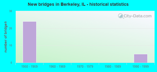
- New bridges - historical statistics
- 241950-1959
- 51990-1999

- Reconstructed bridges - Historical Statistics
- 21960-1969
- 01970-1979
- 21980-1989
- 11990-1999


- Bridge Condition - Deck
- 6.3%Good
- 62.5%Satisfactory
- 18.8%Fair
- 12.5%Poor

- Bridge Condition - Superstructure
- 6.3%Very good
- 12.5%Good
- 75.0%Satisfactory
- 6.3%Fair

- Bridge Condition - Substructure
- 25.0%Good
- 31.3%Satisfactory
- 43.8%Fair
Find on map >> Show street view
Structure Number: 160083, Location: 1.6 M W US 45 (Lat: 41.874892, Lng: -87.913778), Route carried "on" structure: Interstate 290, Year Built: 1959, Year Reconstructed: 1985, Status: Open, Structure Length: 6.57m (21.56ft), Average Daily Traffic: 32,700 (year 2021), Truck Traffic: 12%, Average Future Daily Traffic: 56,805 (year 2032), Design Load: HS 20+Mod, Features Intersected: IL 56 (BUTTERFIELD)
Minimum Vertical Clearance: 30+ m (98+ ft), Kilometerpoint: 25.427, Lanes on structure: 3, Lanes under structure: 5, Base Highway Network: Yes, Owner: State Highway Agency, Approaching Roadway Width: 16.6m (54.5ft), Skew: 4 degrees, Material/Design: Steel continuous, Design/Construction: Stringer/Multi-beam, Number Of Spans In Main Unit: 4, Length of Maximum Span: 17.7m (58.1ft), Curb-To-Curb Width: 16.6m (54.5ft), Out-to-Out Width: 17.6m (57.7ft)
Condition: Deck: Satisfactory, Superstructure: Satisfactory, Substructure: Good, Operating Rating: 55.1 metric tons, Method Used To Determine Operating Rating: Load Factor (LF) rating reported by rating factor (RF) method using MS18 loading, Inventory Rating: 33.0 metric tons, Method Used To Determine Inventory Rating: Load Factor (LF) rating reported by rating factor (RF) method using MS18 loading, Structural Evaluation: Equal to present minimum criteria, Deck Geometry: Equal to present minimum criteria, Underclear: Meets minimum limits, Approach Roadway Alignment: Equal to present desirable criteria, Length Of Structure Improvement: 6.52m (21.39ft), Designated Inspection Frequency: Every 24 months, Inspection Date: March 2020, Bridge Improvement Cost: $462,000, Roadway Improvement Cost: $46,000, Total Project Cost: $762,000, Deck Structure Type: Concrete Cast-file-Place, Wearing Surface/Protective System: Wearing Surface: Latex Concrete, Deck Protection: Epoxy Coated Reinforcing
Find on map >> Show street view
Structure Number: 160084, Location: 1.6 M W US 45 (Lat: 41.874950, Lng: -87.913956), Route carried "on" structure: Interstate 290, Year Built: 1959, Year Reconstructed: 1998, Status: Open, Structure Length: 6.55m (21.49ft), Average Daily Traffic: 32,700 (year 2021), Truck Traffic: 12%, Average Future Daily Traffic: 56,805 (year 2032), Design Load: HS 20+Mod, Features Intersected: IL 56 (BUTTERFIELD)
Minimum Vertical Clearance: 30+ m (98+ ft), Kilometerpoint: 25.411, Lanes on structure: 3, Lanes under structure: 5, Base Highway Network: Yes, Owner: State Highway Agency, Approaching Roadway Width: 11.0m (36.1ft), Skew: 4 degrees, Material/Design: Steel continuous, Design/Construction: Stringer/Multi-beam, Number Of Spans In Main Unit: 4, Length of Maximum Span: 17.7m (58.1ft), Curb-To-Curb Width: 16.5m (54.1ft), Out-to-Out Width: 17.6m (57.7ft)
Condition: Deck: Satisfactory, Superstructure: Satisfactory, Substructure: Good, Operating Rating: 55.1 metric tons, Method Used To Determine Operating Rating: Load Factor (LF) rating reported by rating factor (RF) method using MS18 loading, Inventory Rating: 33.0 metric tons, Method Used To Determine Inventory Rating: Load Factor (LF) rating reported by rating factor (RF) method using MS18 loading, Structural Evaluation: Equal to present minimum criteria, Deck Geometry: Equal to present minimum criteria, Underclear: Meets minimum limits, Approach Roadway Alignment: Equal to present desirable criteria, Length Of Structure Improvement: 6.52m (21.39ft), Designated Inspection Frequency: Every 24 months, Inspection Date: March 2020, Bridge Improvement Cost: $462,000, Roadway Improvement Cost: $46,000, Total Project Cost: $762,000, Deck Structure Type: Concrete Cast-file-Place, Wearing Surface/Protective System: Wearing Surface: Latex Concrete, Deck Protection: Epoxy Coated Reinforcing
Find on map >> Show street view
Structure Number: 160673, Location: 1.2 M S US 20 (Lat: 41.889697, Lng: -87.918389), Route carried "on" structure: Other road , Year Built: 1958, Year Reconstructed: 1992, Status: Open, Structure Length: 5.52m (18.11ft), Average Daily Traffic: 17,100 (year 2018), Truck Traffic: 7%, Average Future Daily Traffic: 17,922 (year 2032), Design Load: HS 20, Features Intersected: I-294 TRI STATE TOLL, Facility Carried by Structure: ST CHARLES RD
Minimum Vertical Clearance: 30+ m (98+ ft), Kilometerpoint: 0.225, Lanes on structure: 6, Lanes under structure: 6, Base Highway Network: Yes, Owner: State Highway Agency, Approaching Roadway Width: 25.0m (82.0ft), Skew: 30 degrees, Material/Design: Steel continuous, Design/Construction: Stringer/Multi-beam, Number Of Spans In Main Unit: 3, Length of Maximum Span: 20.7m (67.9ft), Curb or Sidewalk Widths: Left: 1.5m (4.9ft), Right: 1.5m (4.9ft), Curb-To-Curb Width: 25.0m (82.0ft), Out-to-Out Width: 28.7m (94.2ft)
Condition: Deck: Satisfactory, Superstructure: Satisfactory, Substructure: Satisfactory, Operating Rating: 83.6 metric tons, Method Used To Determine Operating Rating: Load Factor (LF) rating reported by rating factor (RF) method using MS18 loading, Inventory Rating: 50.2 metric tons, Method Used To Determine Inventory Rating: Load Factor (LF) rating reported by rating factor (RF) method using MS18 loading, Structural Evaluation: Equal to present minimum criteria, Deck Geometry: Somewhat better than minimum adequacy, Underclear: Meets minimum limits, Approach Roadway Alignment: Equal to present desirable criteria, Designated Inspection Frequency: Every 24 months, Inspection Date: May 2020, Deck Structure Type: Concrete Cast-file-Place, Wearing Surface/Protective System: Wearing Surface: Latex Concrete, Deck Protection: Epoxy Coated Reinforcing
Find on map >> Show street view
Structure Number: 16268, Location: 0.15M N ILL 56 (Lat: 41.875608, Lng: -87.918075), Route carried "on" structure: Other road , Year Built: 1992, Status: Open, Structure Length: 4.92m (16.14ft), Average Daily Traffic: 22,100 (year 2020), Average Future Daily Traffic: 7,210 (year 2032), Design Load: HS 20, Features Intersected: CCP. RR, Facility Carried by Structure: I294 COLL-DISTR
Minimum Vertical Clearance: 30+ m (98+ ft), Kilometerpoint: 1.223, Lanes on structure: 2, Base Highway Network: Yes (Inventory Route: 10294072, Subroute: 10), Toll: On toll road, Owner: State Toll Authority, Approaching Roadway Width: 16.2m (53.1ft), Material/Design: Prestressed concrete continuous, Design/Construction: Stringer/Multi-beam, Number Of Spans In Main Unit: 3, Number Of Approach Spans: 2, Length of Maximum Span: 17.8m (58.4ft), Curb-To-Curb Width: 16.2m (53.1ft), Out-to-Out Width: 17.2m (56.4ft)
Condition: Deck: Fair, Superstructure: Very good, Substructure: Good, Operating Rating: 76.8 metric tons, Method Used To Determine Operating Rating: Load Factor (LF) rating reported by rating factor (RF) method using MS18 loading, Inventory Rating: 46.0 metric tons, Method Used To Determine Inventory Rating: Load Factor (LF) rating reported by rating factor (RF) method using MS18 loading, Structural Evaluation: Better than present minimum criteria, Deck Geometry: Superior to present desirable criteria, Underclear: Better than present minimum criteria, Approach Roadway Alignment: Equal to present desirable criteria, Designated Inspection Frequency: Every 24 months, Inspection Date: June 2020, Deck Structure Type: Concrete Cast-file-Place, Wearing Surface/Protective System: Wearing Surface: Bituminous, Membrane: Built-up
Find on map >> Show street view
Structure Number: 162682, Location: I290 AT I294 P20 (Lat: 41.876775, Lng: -87.918317), Route carried "on" structure: Other road , Year Built: 1992, Status: Open, Structure Length: 14.66m (48.10ft), Average Daily Traffic: 22,100 (year 2020), Average Future Daily Traffic: 7,210 (year 2032), Design Load: HS 20, Features Intersected: I290, Facility Carried by Structure: I294 COLL-DISTR
Minimum Vertical Clearance: 30+ m (98+ ft), Kilometerpoint: 1.352, Lanes on structure: 3, Lanes under structure: 5, Base Highway Network: Yes (Inventory Route: 10294072, Subroute: 10), Toll: On toll road, Owner: State Toll Authority, Approaching Roadway Width: 14.8m (48.6ft), Material/Design: Prestressed concrete continuous, Design/Construction: Stringer/Multi-beam, Number Of Spans In Main Unit: 4, Length of Maximum Span: 41.8m (137.1ft), Curb-To-Curb Width: 14.8m (48.6ft), Out-to-Out Width: 15.7m (51.5ft)
Condition: Deck: Satisfactory, Superstructure: Good, Substructure: Satisfactory, Operating Rating: 55.7 metric tons, Method Used To Determine Operating Rating: Load Factor (LF) rating reported by rating factor (RF) method using MS18 loading, Inventory Rating: 33.4 metric tons, Method Used To Determine Inventory Rating: Load Factor (LF) rating reported by rating factor (RF) method using MS18 loading, Structural Evaluation: Equal to present minimum criteria, Deck Geometry: Meets minimum limits, Underclear: High priority of corrective action, Approach Roadway Alignment: Equal to present desirable criteria, Designated Inspection Frequency: Every 24 months, Inspection Date: May 2020, Deck Structure Type: Concrete Cast-file-Place, Wearing Surface/Protective System: Wearing Surface: Bituminous, Membrane: Built-up
Find on map >> Show street view
Structure Number: 162683, Location: I294 & ILL 56 P20 (Lat: 41.873803, Lng: -87.917619), Route carried "on" structure: Other road , Year Built: 1992, Status: Open, Structure Length: 2.41m (7.91ft), Average Daily Traffic: 22,100 (year 2020), Average Future Daily Traffic: 7,210 (year 2032), Design Load: HS 20, Features Intersected: BUTTERFIELD R ILL 56, Facility Carried by Structure: I294 COLL-DISTR
Minimum Vertical Clearance: 30+ m (98+ ft), Kilometerpoint: 1.030, Lanes on structure: 3, Lanes under structure: 4, Base Highway Network: Yes (Inventory Route: 10294072, Subroute: 10), Toll: On toll road, Owner: State Toll Authority, Approaching Roadway Width: 14.6m (47.9ft), Material/Design: Concrete, Number Of Spans In Main Unit: 6, Number Of Approach Spans: 2, Length of Maximum Span: 24.1m (79.1ft), Curb-To-Curb Width: 14.6m (47.9ft), Out-to-Out Width: 18.3m (60.0ft)
Condition: Deck: Good, Superstructure: Good, Substructure: Good, Operating Rating: 85.5 metric tons, Method Used To Determine Operating Rating: Load Factor (LF) rating reported by rating factor (RF) method using MS18 loading, Inventory Rating: 51.2 metric tons, Method Used To Determine Inventory Rating: Load Factor (LF) rating reported by rating factor (RF) method using MS18 loading, Structural Evaluation: Better than present minimum criteria, Deck Geometry: Meets minimum limits, Underclear: High priority of corrective action, Approach Roadway Alignment: Equal to present desirable criteria, Designated Inspection Frequency: Every 24 months, Inspection Date: April 2019, Deck Structure Type: Concrete Cast-file-Place, Wearing Surface/Protective System: Wearing Surface: Bituminous, Membrane: Built-up
Find on map >> Show street view
Structure Number: 169794, Location: 0.7 M S US 20 P20 (Lat: 41.897233, Lng: -87.919603), Route carried "on" structure: Interstate 294, Year Built: 1958, Status: Open, Structure Length: 11.19m (36.71ft), Average Daily Traffic: 62,550 (year 2020), Truck Traffic: 15%, Average Future Daily Traffic: 65,199 (year 2032), Features Intersected: C&NW RR
Minimum Vertical Clearance: 30+ m (98+ ft), Kilometerpoint: 32.089, Lanes on structure: 3, Base Highway Network: Yes, Toll: On toll road, Owner: State Toll Authority, Approaching Roadway Width: 15.8m (51.8ft), Skew: 2 degrees, Material/Design: Prestressed concrete, Design/Construction: Stringer/Multi-beam, Number Of Spans In Main Unit: 5, Length of Maximum Span: 26.5m (86.9ft), Curb-To-Curb Width: 14.2m (46.6ft), Out-to-Out Width: 15.5m (50.9ft)
Condition: Deck: Satisfactory, Superstructure: Satisfactory, Substructure: Fair, Operating Rating: 60.9 metric tons, Method Used To Determine Operating Rating: Load Factor (LF) rating reported by rating factor (RF) method using MS18 loading, Inventory Rating: 36.6 metric tons, Method Used To Determine Inventory Rating: Load Factor (LF) rating reported by rating factor (RF) method using MS18 loading, Structural Evaluation: Somewhat better than minimum adequacy, Deck Geometry: Meets minimum limits, Underclear: Equal to present desirable criteria, Approach Roadway Alignment: Equal to present desirable criteria, Designated Inspection Frequency: Every 24 months, Inspection Date: April 2021, Deck Structure Type: Concrete Cast-file-Place, Wearing Surface/Protective System: Wearing Surface: Bituminous, Membrane: Built-up
Find on map >> Show street view
Structure Number: 169795, Location: 0.7 M S US 20 P20 (Lat: 41.897089, Lng: -87.919567), Route carried "on" structure: Interstate 294, Year Built: 1958, Status: Open, Structure Length: 11.19m (36.71ft), Average Daily Traffic: 62,550 (year 2020), Truck Traffic: 15%, Average Future Daily Traffic: 65,199 (year 2032), Features Intersected: C&NW RR
Minimum Vertical Clearance: 30+ m (98+ ft), Kilometerpoint: 32.106, Lanes on structure: 3, Base Highway Network: Yes, Toll: On toll road, Owner: State Toll Authority, Approaching Roadway Width: 15.8m (51.8ft), Skew: 2 degrees, Material/Design: Prestressed concrete, Design/Construction: Stringer/Multi-beam, Number Of Spans In Main Unit: 5, Length of Maximum Span: 26.5m (86.9ft), Curb-To-Curb Width: 14.2m (46.6ft), Out-to-Out Width: 15.5m (50.9ft)
Condition: Deck: Fair, Superstructure: Satisfactory, Substructure: Fair, Operating Rating: 60.9 metric tons, Method Used To Determine Operating Rating: Load Factor (LF) rating reported by rating factor (RF) method using MS18 loading, Inventory Rating: 36.6 metric tons, Method Used To Determine Inventory Rating: Load Factor (LF) rating reported by rating factor (RF) method using MS18 loading, Structural Evaluation: Somewhat better than minimum adequacy, Deck Geometry: Meets minimum limits, Underclear: Equal to present desirable criteria, Approach Roadway Alignment: Equal to present desirable criteria, Designated Inspection Frequency: Every 24 months, Inspection Date: April 2021, Deck Structure Type: Concrete Cast-file-Place, Wearing Surface/Protective System: Wearing Surface: Bituminous, Membrane: Built-up
Find on map >> Show street view
Structure Number: 169796, Location: 1.7 M S US 20 P20 (Lat: 41.884500, Lng: -87.919425), Route carried "on" structure: Interstate 294, Year Built: 1958, Status: Open, Structure Length: 11.98m (39.30ft), Average Daily Traffic: 62,550 (year 2020), Truck Traffic: 15%, Average Future Daily Traffic: 65,199 (year 2032), Features Intersected: C&NW RR
Minimum Vertical Clearance: 30+ m (98+ ft), Kilometerpoint: 33.650, Lanes on structure: 3, Base Highway Network: Yes, Toll: On toll road, Owner: State Toll Authority, Approaching Roadway Width: 15.8m (51.8ft), Material/Design: Prestressed concrete, Design/Construction: Stringer/Multi-beam, Number Of Spans In Main Unit: 5, Length of Maximum Span: 25.9m (85.0ft), Curb-To-Curb Width: 16.5m (54.1ft), Out-to-Out Width: 17.7m (58.1ft)
Condition: Deck: Poor, Superstructure: Satisfactory, Substructure: Fair, Operating Rating: 57.0 metric tons, Method Used To Determine Operating Rating: Load Factor (LF) rating reported by rating factor (RF) method using MS18 loading, Inventory Rating: 34.0 metric tons, Method Used To Determine Inventory Rating: Load Factor (LF) rating reported by rating factor (RF) method using MS18 loading, Structural Evaluation: Somewhat better than minimum adequacy, Deck Geometry: Equal to present minimum criteria, Underclear: High priority of corrective action, Approach Roadway Alignment: Equal to present desirable criteria, Designated Inspection Frequency: Every 24 months, Inspection Date: May 2020, Deck Structure Type: Concrete Cast-file-Place, Wearing Surface/Protective System: Wearing Surface: Bituminous, Membrane: Built-up
Find on map >> Show street view
Structure Number: 169797, Location: 1.7 M S US 20 P20 (Lat: 41.884383, Lng: -87.919447), Route carried "on" structure: Interstate 294, Year Built: 1958, Status: Open, Structure Length: 11.98m (39.30ft), Average Daily Traffic: 62,550 (year 2020), Truck Traffic: 15%, Average Future Daily Traffic: 65,199 (year 2032), Features Intersected: C&NW RR
Minimum Vertical Clearance: 30+ m (98+ ft), Kilometerpoint: 33.667, Lanes on structure: 3, Base Highway Network: Yes, Toll: On toll road, Owner: State Toll Authority, Approaching Roadway Width: 18.9m (62.0ft), Material/Design: Prestressed concrete, Design/Construction: Stringer/Multi-beam, Number Of Spans In Main Unit: 5, Length of Maximum Span: 25.9m (85.0ft), Curb-To-Curb Width: 16.5m (54.1ft), Out-to-Out Width: 17.7m (58.1ft)
Condition: Deck: Satisfactory, Superstructure: Satisfactory, Substructure: Fair, Operating Rating: 54.1 metric tons, Method Used To Determine Operating Rating: Load Factor (LF) rating reported by rating factor (RF) method using MS18 loading, Inventory Rating: 32.4 metric tons, Method Used To Determine Inventory Rating: Load Factor (LF) rating reported by rating factor (RF) method using MS18 loading, Structural Evaluation: Somewhat better than minimum adequacy, Deck Geometry: Equal to present minimum criteria, Underclear: High priority of corrective action, Approach Roadway Alignment: Equal to present desirable criteria, Designated Inspection Frequency: Every 24 months, Inspection Date: May 2020, Deck Structure Type: Concrete Cast-file-Place, Wearing Surface/Protective System: Wearing Surface: Bituminous, Membrane: Built-up
Find on map >> Show street view
Structure Number: 169798, Location: I290 AT I294 P20 (Lat: 41.877642, Lng: -87.919114), Route carried "on" structure: Interstate 294, Year Built: 1958, Status: Open, Structure Length: 14.94m (49.02ft), Average Daily Traffic: 65,850 (year 2020), Truck Traffic: 15%, Average Future Daily Traffic: 69,886 (year 2032), Features Intersected: I290
Minimum Vertical Clearance: 30+ m (98+ ft), Kilometerpoint: 34.262, Lanes on structure: 4, Lanes under structure: 6, Base Highway Network: Yes, Toll: On toll road, Owner: State Toll Authority, Approaching Roadway Width: 15.8m (51.8ft), Skew: 6 degrees, Material/Design: Prestressed concrete, Design/Construction: Stringer/Multi-beam, Number Of Spans In Main Unit: 4, Length of Maximum Span: 50.3m (165.0ft), Curb-To-Curb Width: 16.5m (54.1ft), Out-to-Out Width: 17.7m (58.1ft)
Condition: Deck: Satisfactory, Superstructure: Satisfactory, Substructure: Satisfactory, Operating Rating: 97.2 metric tons, Method Used To Determine Operating Rating: Load Factor (LF) rating reported by rating factor (RF) method using MS18 loading, Inventory Rating: 72.9 metric tons, Method Used To Determine Inventory Rating: Load Factor (LF) rating reported by rating factor (RF) method using MS18 loading, Structural Evaluation: Equal to present minimum criteria, Deck Geometry: Meets minimum limits, Underclear: High priority of corrective action, Approach Roadway Alignment: Equal to present desirable criteria, Length Of Structure Improvement: 14.94m (49.02ft), Designated Inspection Frequency: Every 24 months, Inspection Date: May 2020, Bridge Improvement Cost: $1,790,000, Roadway Improvement Cost: $179,000, Total Project Cost: $2,685,000, Deck Structure Type: Concrete Cast-file-Place, Wearing Surface/Protective System: Wearing Surface: Bituminous, Membrane: Built-up
Find on map >> Show street view
Structure Number: 169799, Location: I290 AT I294 P20 (Lat: 41.877503, Lng: -87.919097), Route carried "on" structure: Interstate 294, Year Built: 1958, Status: Open, Structure Length: 14.94m (49.02ft), Average Daily Traffic: 65,850 (year 2020), Truck Traffic: 15%, Average Future Daily Traffic: 69,886 (year 2032), Features Intersected: I290
Minimum Vertical Clearance: 30+ m (98+ ft), Kilometerpoint: 34.278, Lanes on structure: 4, Lanes under structure: 6, Base Highway Network: Yes, Toll: On toll road, Owner: State Toll Authority, Approaching Roadway Width: 15.8m (51.8ft), Skew: 6 degrees, Material/Design: Prestressed concrete, Design/Construction: Stringer/Multi-beam, Number Of Spans In Main Unit: 4, Length of Maximum Span: 50.3m (165.0ft), Curb-To-Curb Width: 16.5m (54.1ft), Out-to-Out Width: 17.7m (58.1ft)
Condition: Deck: Satisfactory, Superstructure: Satisfactory, Substructure: Satisfactory, Operating Rating: 97.2 metric tons, Method Used To Determine Operating Rating: Load Factor (LF) rating reported by rating factor (RF) method using MS18 loading, Inventory Rating: 66.1 metric tons, Method Used To Determine Inventory Rating: Load Factor (LF) rating reported by rating factor (RF) method using MS18 loading, Structural Evaluation: Equal to present minimum criteria, Deck Geometry: Meets minimum limits, Underclear: High priority of corrective action, Approach Roadway Alignment: Equal to present desirable criteria, Designated Inspection Frequency: Every 24 months, Inspection Date: May 2020, Deck Structure Type: Concrete Cast-file-Place, Wearing Surface/Protective System: Wearing Surface: Bituminous, Membrane: Built-up
Find on map >> Show street view
Structure Number: 1698, Location: 0.15M N ILL 56 (Lat: 41.876392, Lng: -87.918911), Route carried "on" structure: Interstate 294, Year Built: 1958, Year Reconstructed: 1973, Status: Open, Structure Length: 4.97m (16.31ft), Average Daily Traffic: 65,850 (year 2020), Truck Traffic: 15%, Average Future Daily Traffic: 69,886 (year 2032), Features Intersected: CC RR
Minimum Vertical Clearance: 30+ m (98+ ft), Kilometerpoint: 34.407, Lanes on structure: 3, Base Highway Network: Yes, Toll: On toll road, Owner: State Toll Authority, Approaching Roadway Width: 15.8m (51.8ft), Skew: 3 degrees, Material/Design: Prestressed concrete, Design/Construction: Stringer/Multi-beam, Number Of Spans In Main Unit: 3, Length of Maximum Span: 17.1m (56.1ft), Curb-To-Curb Width: 14.2m (46.6ft), Out-to-Out Width: 21.0m (68.9ft)
Condition: Deck: Fair, Superstructure: Satisfactory, Substructure: Fair, Operating Rating: 63.8 metric tons, Method Used To Determine Operating Rating: Load Factor (LF) rating reported by rating factor (RF) method using MS18 loading, Inventory Rating: 38.2 metric tons, Method Used To Determine Inventory Rating: Load Factor (LF) rating reported by rating factor (RF) method using MS18 loading, Structural Evaluation: Somewhat better than minimum adequacy, Deck Geometry: Meets minimum limits, Underclear: Superior to present desirable criteria, Approach Roadway Alignment: Equal to present desirable criteria, Designated Inspection Frequency: Every 24 months, Inspection Date: June 2020, Deck Structure Type: Concrete Cast-file-Place, Wearing Surface/Protective System: Wearing Surface: Bituminous, Membrane: Built-up
Find on map >> Show street view
Structure Number: 169801, Location: 0.15M N ILL 56 (Lat: 41.876253, Lng: -87.918883), Route carried "on" structure: Interstate 294, Year Built: 1958, Year Reconstructed: 1973, Status: Open, Structure Length: 4.97m (16.31ft), Average Daily Traffic: 65,850 (year 2020), Truck Traffic: 15%, Average Future Daily Traffic: 69,886 (year 2032), Features Intersected: CC RR
Minimum Vertical Clearance: 30+ m (98+ ft), Kilometerpoint: 34.423, Lanes on structure: 3, Base Highway Network: Yes, Toll: On toll road, Owner: State Toll Authority, Approaching Roadway Width: 15.8m (51.8ft), Skew: 3 degrees, Material/Design: Prestressed concrete, Design/Construction: Stringer/Multi-beam, Number Of Spans In Main Unit: 3, Length of Maximum Span: 17.1m (56.1ft), Curb-To-Curb Width: 14.2m (46.6ft), Out-to-Out Width: 23.0m (75.5ft)
Condition: Deck: Satisfactory, Superstructure: Satisfactory, Substructure: Fair, Operating Rating: 63.8 metric tons, Method Used To Determine Operating Rating: Load Factor (LF) rating reported by rating factor (RF) method using MS18 loading, Inventory Rating: 38.2 metric tons, Method Used To Determine Inventory Rating: Load Factor (LF) rating reported by rating factor (RF) method using MS18 loading, Structural Evaluation: Somewhat better than minimum adequacy, Deck Geometry: Meets minimum limits, Underclear: Superior to present desirable criteria, Approach Roadway Alignment: Equal to present desirable criteria, Designated Inspection Frequency: Every 24 months, Inspection Date: June 2020, Deck Structure Type: Concrete Cast-file-Place, Wearing Surface/Protective System: Wearing Surface: Bituminous, Membrane: Built-up
Find on map >> Show street view
Structure Number: 169802, Location: I294 & ILL 56 P20 (Lat: 41.873644, Lng: -87.918269), Route carried "on" structure: Interstate 294, Year Built: 1958, Status: Open, Structure Length: 2.59m (8.50ft), Average Daily Traffic: 65,850 (year 2020), Truck Traffic: 15%, Average Future Daily Traffic: 69,886 (year 2032), Features Intersected: BUTTERFIELD R ILL 56
Minimum Vertical Clearance: 30+ m (98+ ft), Kilometerpoint: 34.729, Lanes on structure: 3, Lanes under structure: 2, Base Highway Network: Yes, Toll: On toll road, Owner: State Toll Authority, Approaching Roadway Width: 15.8m (51.8ft), Material/Design: Prestressed concrete, Design/Construction: Stringer/Multi-beam, Number Of Spans In Main Unit: 1, Length of Maximum Span: 24.4m (80.1ft), Curb-To-Curb Width: 16.5m (54.1ft), Out-to-Out Width: 21.0m (68.9ft)
Condition: Deck: Satisfactory, Superstructure: Satisfactory, Substructure: Satisfactory, Operating Rating: 97.2 metric tons, Method Used To Determine Operating Rating: Load Factor (LF) rating reported by rating factor (RF) method using MS18 loading, Inventory Rating: 59.6 metric tons, Method Used To Determine Inventory Rating: Load Factor (LF) rating reported by rating factor (RF) method using MS18 loading, Structural Evaluation: Equal to present minimum criteria, Deck Geometry: Equal to present minimum criteria, Underclear: Equal to present minimum criteria, Approach Roadway Alignment: Equal to present desirable criteria, Designated Inspection Frequency: Every 24 months, Inspection Date: April 2021, Deck Structure Type: Concrete Cast-file-Place, Wearing Surface/Protective System: Wearing Surface: Bituminous, Membrane: Built-up
Find on map >> Show street view
Structure Number: 169862, Location: I294 RMP TO I290 P20 (Lat: 41.880161, Lng: -87.920339), Route carried "on" structure: Other road , Year Built: 1958, Status: Open, Structure Length: 7.92m (25.98ft), Average Daily Traffic: 5,400 (year 2021), Average Future Daily Traffic: 8,034 (year 2032), Features Intersected: I290, Facility Carried by Structure: I-294 SB TO I-290
Minimum Vertical Clearance: 30+ m (98+ ft), Kilometerpoint: 0.338, Lanes on structure: 2, Lanes under structure: 6, Base Highway Network: Yes (Inventory Route: 10294042, Subroute: 90), Owner: State Toll Authority, Approaching Roadway Width: 12.2m (40.0ft), Skew: 4 degrees, Material/Design: Prestressed concrete, Design/Construction: Stringer/Multi-beam, Number Of Spans In Main Unit: 4, Length of Maximum Span: 23.2m (76.1ft), Curb-To-Curb Width: 11.7m (38.4ft), Out-to-Out Width: 12.5m (41.0ft)
Condition: Deck: Poor, Superstructure: Fair, Substructure: Fair, Operating Rating: 60.9 metric tons, Method Used To Determine Operating Rating: Load Factor (LF) rating reported by rating factor (RF) method using MS18 loading, Inventory Rating: 36.6 metric tons, Method Used To Determine Inventory Rating: Load Factor (LF) rating reported by rating factor (RF) method using MS18 loading, Structural Evaluation: Somewhat better than minimum adequacy, Deck Geometry: Equal to present minimum criteria, Underclear: Meets minimum limits, Approach Roadway Alignment: Equal to present minimum criteria, Designated Inspection Frequency: Every 24 months, Inspection Date: May 2020, Deck Structure Type: Concrete Cast-file-Place, Wearing Surface/Protective System: Wearing Surface: Bituminous, Membrane: Built-up
Find on map >> Show street view
Structure Number: 160083, Location: 1.6 M W US 45 (Lat: 41.874831, Lng: -87.913603), Route carried "under" structure: State highway 56, Year Built: 1959, Structure Length: 0. m, Average Daily Traffic: 11,800 (year 2021), Truck Traffic: 4%, Features Intersected: IL 56 (BUTTERFIELD), Facility Carried by Structure: I-290 WB
Minimum Vertical Clearance: 4.52m (14.83ft), Kilometerpoint: 49.196, Lanes on structure: 3, Lanes under structure: 5, Material/Design: Steel continuous, Design/Construction: Stringer/Multi-beam, Length of Maximum Span: 17.7m (58.1ft)
Find on map >> Show street view
Structure Number: 160084, Location: 1.6 M W US 45 (Lat: 41.874756, Lng: -87.913908), Route carried "under" structure: State highway 56, Year Built: 1959, Structure Length: 0. m, Average Daily Traffic: 11,800 (year 2021), Truck Traffic: 4%, Features Intersected: IL 56 (BUTTERFIELD), Facility Carried by Structure: I-290 EB
Minimum Vertical Clearance: 4.60m (15.09ft), Kilometerpoint: 49.148, Lanes on structure: 3, Lanes under structure: 5, Material/Design: Steel continuous, Design/Construction: Stringer/Multi-beam, Length of Maximum Span: 17.7m (58.1ft)
Find on map >> Show street view
Structure Number: 160645, Location: JUST W I290 P20 (Lat: 41.874631, Lng: -87.914417), Route carried "under" structure: State highway 56, Year Built: 1959, Structure Length: 0. m, Average Daily Traffic: 11,800 (year 2021), Truck Traffic: 4%, Features Intersected: ILL 56(BUTTERFIELD), Facility Carried by Structure: IC RR
Minimum Vertical Clearance: 4.90m (16.08ft), Kilometerpoint: 49.100, Lanes under structure: 4, Material/Design: Steel, Length of Maximum Span: 18.9m (62.0ft)
Find on map >> Show street view
Structure Number: 160673, Location: 1.2 M S US 20 (Lat: 41.889689, Lng: -87.918122), Route carried "under" structure: Interstate 294, Year Built: 1958, Structure Length: 0. m, Average Daily Traffic: 125,100 (year 2020), Truck Traffic: 15%, Features Intersected: I-294 TRI STATE TOLL, Facility Carried by Structure: ST CHARLES RD
Minimum Vertical Clearance: 4.65m (15.26ft), Kilometerpoint: 32.942, Lanes on structure: 6, Lanes under structure: 6, Material/Design: Steel continuous, Design/Construction: Stringer/Multi-beam, Length of Maximum Span: 20.7m (67.9ft)
Find on map >> Show street view
Structure Number: 161134, Location: 1.5 M S IL 64 (Lat: 41.882069, Lng: -87.912981), Route carried "under" structure: City street , Year Built: 1952, Structure Length: 0. m, Average Daily Traffic: 1,150 (year 2018), Truck Traffic: 8%, Features Intersected: ELECTRIC AV&PRAIRIE, Facility Carried by Structure: I-290 SB
Minimum Vertical Clearance: 6.40m (21.00ft), Kilometerpoint: 0.612, Lanes on structure: 2, Lanes under structure: 2, Material/Design: Steel continuous, Design/Construction: Stringer/Multi-beam, Length of Maximum Span: 26.2m (86.0ft)
Find on map >> Show street view
Structure Number: 161135, Location: 1.5 M S IL 64 (Lat: 41.882086, Lng: -87.913178), Route carried "under" structure: City street , Year Built: 1952, Structure Length: 0. m, Average Daily Traffic: 1,150 (year 2018), Truck Traffic: 8%, Features Intersected: ELECTRIC AV&PRAIRIE, Facility Carried by Structure: I-290 NB
Minimum Vertical Clearance: 6.71m (22.01ft), Kilometerpoint: 0.612, Lanes on structure: 2, Lanes under structure: 2, Material/Design: Steel continuous, Design/Construction: Stringer/Multi-beam, Length of Maximum Span: 26.2m (86.0ft)
Find on map >> Show street view
Structure Number: 162682, Location: I290 AT I294 P20 (Lat: 41.877108, Lng: -87.918261), Route carried "under" structure: Interstate 290, Year Built: 1992, Structure Length: 0. m, Average Daily Traffic: 87,700 (year 2021), Truck Traffic: 8%, Features Intersected: I290, Facility Carried by Structure: I294 COLL-DISTR
Minimum Vertical Clearance: 8.28m (27.17ft), Kilometerpoint: 24.976, Lanes on structure: 3, Lanes under structure: 5, Toll: On toll road, Material/Design: Prestressed concrete continuous, Design/Construction: Stringer/Multi-beam, Length of Maximum Span: 41.8m (137.1ft)
Find on map >> Show street view
Structure Number: 162683, Location: I294 & ILL 56 P20 (Lat: 41.873867, Lng: -87.917389), Route carried "under" structure: State highway 56, Year Built: 1992, Structure Length: 0. m, Average Daily Traffic: 11,800 (year 2021), Truck Traffic: 4%, Features Intersected: BUTTERFIELD R ILL 56, Facility Carried by Structure: I294 COLL-DISTR
Minimum Vertical Clearance: 4.57m (14.99ft), Kilometerpoint: 48.826, Lanes on structure: 3, Lanes under structure: 4, Toll: On toll road, Material/Design: Concrete, Length of Maximum Span: 24.1m (79.1ft)
Find on map >> Show street view
Structure Number: 169798, Location: I290 AT I294 P20 (Lat: 41.878189, Lng: -87.919256), Route carried "under" structure: Interstate 290, Year Built: 1958, Structure Length: 0. m, Average Daily Traffic: 87,700 (year 2021), Truck Traffic: 8%, Features Intersected: I290, Facility Carried by Structure: I-294 SB
Minimum Vertical Clearance: 7.32m (24.02ft), Kilometerpoint: 24.896, Lanes on structure: 4, Lanes under structure: 6, Toll: On toll road, Material/Design: Prestressed concrete, Design/Construction: Stringer/Multi-beam, Length of Maximum Span: 50.3m (165.0ft)
Find on map >> Show street view
Structure Number: 169799, Location: I290 AT I294 P20 (Lat: 41.877300, Lng: -87.918472), Route carried "under" structure: Interstate 290, Year Built: 1958, Structure Length: 0. m, Average Daily Traffic: 87,700 (year 2021), Truck Traffic: 8%, Features Intersected: I290, Facility Carried by Structure: I-294 NB
Minimum Vertical Clearance: 7.32m (24.02ft), Kilometerpoint: 24.960, Lanes on structure: 4, Lanes under structure: 6, Toll: On toll road, Material/Design: Prestressed concrete, Design/Construction: Stringer/Multi-beam, Length of Maximum Span: 50.3m (165.0ft)
Find on map >> Show street view
Structure Number: 169802, Location: I294 & ILL 56 P20 (Lat: 41.873644, Lng: -87.918269), Route carried "under" structure: State highway 56, Year Built: 1958, Structure Length: 0. m, Average Daily Traffic: 11,800 (year 2021), Truck Traffic: 4%, Features Intersected: BUTTERFIELD R ILL 56, Facility Carried by Structure: I-294 NB
Minimum Vertical Clearance: 4.78m (15.68ft), Kilometerpoint: 48.778, Lanes on structure: 3, Lanes under structure: 2, Toll: On toll road, Material/Design: Prestressed concrete, Design/Construction: Stringer/Multi-beam, Length of Maximum Span: 24.4m (80.1ft)
Find on map >> Show street view
Structure Number: 169803, Location: I294 & ILL 56 P20 (Lat: 41.873606, Lng: -87.918419), Route carried "under" structure: State highway 56, Year Built: 1958, Structure Length: 0. m, Average Daily Traffic: 11,800 (year 2021), Truck Traffic: 4%, Features Intersected: BUTTERFIELD R ILL 56, Facility Carried by Structure: I-294 SB
Minimum Vertical Clearance: 4.60m (15.09ft), Kilometerpoint: 48.746, Lanes on structure: 3, Lanes under structure: 2, Toll: On toll road, Material/Design: Prestressed concrete, Design/Construction: Stringer/Multi-beam, Length of Maximum Span: 24.4m (80.1ft)
Find on map >> Show street view
Structure Number: 169862, Location: I294 RMP TO I290 P20 (Lat: 41.880161, Lng: -87.920339), Route carried "under" structure: Interstate 290, Year Built: 1958, Structure Length: 0. m, Average Daily Traffic: 87,700 (year 2021), Truck Traffic: 8%, Features Intersected: I290
Minimum Vertical Clearance: 4.78m (15.68ft), Kilometerpoint: 24.590, Lanes on structure: 2, Lanes under structure: 6, Material/Design: Prestressed concrete, Design/Construction: Stringer/Multi-beam, Length of Maximum Span: 23.2m (76.1ft)