Bridge Statistics for Berrien Springs, Michigan (MI)
Condition, Traffic, Stress, Structural Evaluation, Project Costs
- National Bridge Inventory (NBI) Statistics
- 15Number of bridges
- 407ft / 124mTotal length
- 147,951Total average daily traffic
- 17,644Total average daily truck traffic
- National Bridge Inventory (NBI) Registered Bridges for Berrien Springs
- No street view available for this location
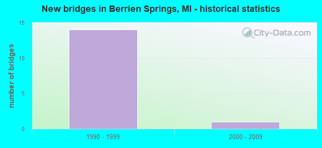
- New bridges - historical statistics
- 141990-1999
- 12000-2009


- Bridge Condition - Deck
- 71.4%Good
- 28.6%Satisfactory

- Bridge Condition - Superstructure
- 14.3%Good
- 14.3%Satisfactory
- 71.4%Fair

- Bridge Condition - Substructure
- 85.7%Good
- 14.3%Satisfactory

- Bridge Condition - Channel
- 16.7%Good
- 16.7%Satisfactory
- 66.7%Fair
Find on map >> Show street view
Structure Number: 874, Location: IN BERRIEN SPRINGS (Lat: 41.949292, Lng: -86.334164), Route carried "on" structure: Business State highway 139, Year Built: 1994, Status: Open, Structure Length: 12.19m (39.99ft), Average Daily Traffic: 11,806 (year 2007), Truck Traffic: 2%, Average Future Daily Traffic: 22,430 (year 2018), Design Load: HS 25 or greater, Features Intersected: ST JOSEPH RIVER
Minimum Vertical Clearance: 30.48m (100.00ft), Kilometerpoint: 15.198, Lanes on structure: 2, Base Highway Network: Yes (Inventory Route: 136, Subroute: 9), Owner: State Highway Agency, Approaching Roadway Width: 10.7m (35.1ft), Skew: 2 degrees, Navigation Control: Yes ( Vertical Clearance: 0.3m (1.0ft), Horizontal Clearance: 7.4m (24.3ft)), Material/Design: Prestressed concrete, Design/Construction: Stringer/Multi-beam, Number Of Spans In Main Unit: 4, Length of Maximum Span: 30.4m (99.7ft), Curb or Sidewalk Widths: Left: 1.5m (4.9ft), Right: 1.5m (4.9ft), Curb-To-Curb Width: 10.7m (35.1ft), Out-to-Out Width: 14.2m (46.6ft)
Condition: Deck: Good, Superstructure: Fair, Substructure: Good, Channel: Satisfactory, Operating Rating: 65.4 metric tons, Method Used To Determine Operating Rating: Load Factor (LF) rating reported by rating factor (RF) method using MS18 loading, Inventory Rating: 35.0 metric tons, Method Used To Determine Inventory Rating: Load Factor (LF) rating reported by rating factor (RF) method using MS18 loading, Structural Evaluation: Somewhat better than minimum adequacy, Deck Geometry: Meets minimum limits, Waterway Adequacy: Equal to present minimum criteria, Approach Roadway Alignment: Equal to present minimum criteria, Designated Inspection Frequency: Every 24 months, Underwater Inspection Frequency: Every 60 months, Inspection Date: July 2020, Underwater Inspection Date: July 2017, Bridge Improvement Cost: $141,000, Deck Structure Type: Concrete Cast-file-Place, Wearing Surface/Protective System: Wearing Surface: Monolithic Concrete, Deck Protection: Epoxy Coated Reinforcing
Find on map >> Show street view
Structure Number: 892, Location: 5.5 MI SW OF BERRIEN SPRG (Lat: 41.923406, Lng: -86.356031), Route carried "on" structure: US 31, Year Built: 1990, Status: Open, Structure Length: 26.29m (86.25ft), Average Daily Traffic: 7,859 (year 2007), Truck Traffic: 12%, Average Future Daily Traffic: 8,198 (year 2018), Design Load: HS 25 or greater, Features Intersected: ST JOSEPH RIVER
Minimum Vertical Clearance: 30.48m (100.00ft), Kilometerpoint: 19.961, Lanes on structure: 2, Base Highway Network: Yes (Inventory Route: 177, Subroute: 5), Owner: State Highway Agency, Approaching Roadway Width: 11.9m (39.0ft), Material/Design: Prestressed concrete, Design/Construction: Stringer/Multi-beam, Number Of Spans In Main Unit: 7, Length of Maximum Span: 37.7m (123.7ft), Curb-To-Curb Width: 13.5m (44.3ft), Out-to-Out Width: 14.4m (47.2ft)
Condition: Deck: Satisfactory, Superstructure: Fair, Substructure: Satisfactory, Channel: Fair, Operating Rating: 81.3 metric tons, Method Used To Determine Operating Rating: Load Factor (LF) rating reported by rating factor (RF) method using MS18 loading, Inventory Rating: 37.6 metric tons, Method Used To Determine Inventory Rating: Load Factor (LF) rating reported by rating factor (RF) method using MS18 loading, Structural Evaluation: Somewhat better than minimum adequacy, Deck Geometry: Superior to present desirable criteria, Waterway Adequacy: Equal to present desirable criteria, Approach Roadway Alignment: Equal to present desirable criteria, Designated Inspection Frequency: Every 24 months, Underwater Inspection Frequency: Every 60 months, Inspection Date: July 2020, Underwater Inspection Date: August 2017, Deck Structure Type: Concrete Cast-file-Place, Wearing Surface/Protective System: Wearing Surface: Epoxy Overlay, Deck Protection: Epoxy Coated Reinforcing
Find on map >> Show street view
Structure Number: 893, Location: 1.5 MI N OF SNOW ROAD (Lat: 41.950256, Lng: -86.375011), Route carried "on" structure: US 31, Year Built: 1990, Status: Open, Structure Length: 0.61m (2.00ft), Average Daily Traffic: 11,984 (year 2007), Truck Traffic: 15%, Average Future Daily Traffic: 12,828 (year 2018), Design Load: HS 25 or greater, Features Intersected: LEMON CREEK
Minimum Vertical Clearance: 30.48m (100.00ft), Kilometerpoint: 23.431, Lanes on structure: 4, Base Highway Network: Yes (Inventory Route: 177, Subroute: 3), Owner: State Highway Agency, Approaching Roadway Width: 24.4m (80.1ft), Material/Design: Concrete, Design/Construction: Culvert, Number Of Spans In Main Unit: 1, Length of Maximum Span: 6.1m (20.0ft), Out-to-Out Width: 82.9m (272.0ft)
Condition: Channel: Fair, Culverts: Good, Operating Rating: 67.6 metric tons, Method Used To Determine Operating Rating: Field evaluation and documented engineering judgment, Inventory Rating: 40.5 metric tons, Method Used To Determine Inventory Rating: Field evaluation and documented engineering judgment, Structural Evaluation: Better than present minimum criteria, Waterway Adequacy: Better than present minimum criteria, Approach Roadway Alignment: Equal to present desirable criteria, Designated Inspection Frequency: Every 24 months, Inspection Date: April 2020
Find on map >> Show street view
Structure Number: 12697, Location: 7.9 MI N OF US-12 (Lat: 41.910397, Lng: -86.339839), Route carried "on" structure: County highway , Year Built: 1997, Status: Open, Structure Length: 9.75m (31.99ft), Average Daily Traffic: 2,200 (year 1997), Truck Traffic: 2%, Average Future Daily Traffic: 2,200 (year 2015), Design Load: HS 20, Features Intersected: US-31, Facility Carried by Structure: RANGE LINE ROAD
Minimum Vertical Clearance: 30.48m (100.00ft), Kilometerpoint: 7.704, Lanes on structure: 2, Lanes under structure: 4, Owner: State Highway Agency, Approaching Roadway Width: 9.9m (32.5ft), Skew: 2 degrees, Material/Design: Steel continuous, Design/Construction: Stringer/Multi-beam, Number Of Spans In Main Unit: 2, Length of Maximum Span: 49.9m (163.7ft), Curb-To-Curb Width: 14.0m (45.9ft), Out-to-Out Width: 14.4m (47.2ft)
Condition: Deck: Good, Superstructure: Satisfactory, Substructure: Good, Operating Rating: 52.2 metric tons, Method Used To Determine Operating Rating: Load Factor (LF) rating reported by rating factor (RF) method using MS18 loading, Inventory Rating: 31.4 metric tons, Method Used To Determine Inventory Rating: Load Factor (LF) rating reported by rating factor (RF) method using MS18 loading, Structural Evaluation: Equal to present minimum criteria, Deck Geometry: Superior to present desirable criteria, Underclear: Equal to present minimum criteria, Approach Roadway Alignment: Equal to present desirable criteria, Designated Inspection Frequency: Every 24 months, Inspection Date: May 2020, Deck Structure Type: Concrete Cast-file-Place, Wearing Surface/Protective System: Wearing Surface: Monolithic Concrete, Deck Protection: Epoxy Coated Reinforcing
Find on map >> Show street view
Structure Number: 12698, Location: 2.0 MI NW BERRIEN SPRINGS (Lat: 41.963447, Lng: -86.374422), Route carried "on" structure: State highway 139, Year Built: 1997, Status: Open, Structure Length: 12.29m (40.32ft), Average Daily Traffic: 10,910 (year 2007), Truck Traffic: 8%, Average Future Daily Traffic: 10,925 (year 2018), Design Load: HS 25 or greater, Features Intersected: US-31
Minimum Vertical Clearance: 30.48m (100.00ft), Kilometerpoint: 4.345, Lanes on structure: 6, Lanes under structure: 5, Base Highway Network: Yes (Inventory Route: 311, Subroute: 92), Owner: State Highway Agency, Approaching Roadway Width: 29.2m (95.8ft), Skew: 2 degrees, Material/Design: Prestressed concrete, Design/Construction: Stringer/Multi-beam, Number Of Spans In Main Unit: 5, Length of Maximum Span: 36.3m (119.1ft), Curb-To-Curb Width: 29.2m (95.8ft), Out-to-Out Width: 30.3m (99.4ft)
Condition: Deck: Satisfactory, Superstructure: Fair, Substructure: Good, Operating Rating: 69.6 metric tons, Method Used To Determine Operating Rating: Load Factor (LF), Inventory Rating: 30.7 metric tons, Method Used To Determine Inventory Rating: Load Factor (LF), Structural Evaluation: Somewhat better than minimum adequacy, Deck Geometry: Superior to present desirable criteria, Underclear: Equal to present minimum criteria, Approach Roadway Alignment: Equal to present desirable criteria, Designated Inspection Frequency: Every 24 months, Inspection Date: May 2020, Deck Structure Type: Concrete Cast-file-Place, Wearing Surface/Protective System: Wearing Surface: Monolithic Concrete, Deck Protection: Epoxy Coated Reinforcing
Find on map >> Show street view
Structure Number: 12752, Location: 1.5 MI N OF OLD US-31 (Lat: 41.986333, Lng: -86.370539), Route carried "on" structure: US 31, Year Built: 1998, Status: Open, Structure Length: 27.56m (90.42ft), Average Daily Traffic: 5,465 (year 2007), Truck Traffic: 16%, Average Future Daily Traffic: 5,802 (year 2018), Design Load: HS 25 or greater, Features Intersected: ST JOSEPH RIVER
Minimum Vertical Clearance: 30.48m (100.00ft), Kilometerpoint: 27.484, Lanes on structure: 2, Base Highway Network: Yes (Inventory Route: 177, Subroute: 3), Owner: State Highway Agency, Approaching Roadway Width: 11.6m (38.1ft), Skew: 2 degrees, Navigation Control: Yes ( Vertical Clearance: 4.0m (13.1ft), Horizontal Clearance: 34.7m (113.8ft)), Material/Design: Prestressed concrete, Design/Construction: Stringer/Multi-beam, Number Of Spans In Main Unit: 8, Length of Maximum Span: 36.1m (118.4ft), Curb-To-Curb Width: 13.4m (44.0ft), Out-to-Out Width: 14.4m (47.2ft)
Condition: Deck: Good, Superstructure: Fair, Substructure: Good, Channel: Fair, Operating Rating: 65.8 metric tons, Method Used To Determine Operating Rating: Load Factor (LF) rating reported by rating factor (RF) method using MS18 loading, Inventory Rating: 40.5 metric tons, Method Used To Determine Inventory Rating: Load Factor (LF) rating reported by rating factor (RF) method using MS18 loading, Structural Evaluation: Somewhat better than minimum adequacy, Deck Geometry: Superior to present desirable criteria, Waterway Adequacy: Equal to present minimum criteria, Approach Roadway Alignment: Equal to present desirable criteria, Designated Inspection Frequency: Every 24 months, Underwater Inspection Frequency: Every 60 months, Inspection Date: July 2020, Underwater Inspection Date: August 2017, Deck Structure Type: Concrete Cast-file-Place, Wearing Surface/Protective System: Wearing Surface: Monolithic Concrete, Deck Protection: Epoxy Coated Reinforcing
Find on map >> Show street view
Structure Number: 12753, Location: 1.5 MI N OF OLD US-31 (Lat: 41.986453, Lng: -86.371053), Route carried "on" structure: US 31, Year Built: 1999, Status: Open, Structure Length: 24.97m (81.92ft), Average Daily Traffic: 5,465 (year 2007), Truck Traffic: 16%, Average Future Daily Traffic: 5,802 (year 2018), Design Load: HS 25 or greater, Features Intersected: ST JOSEPH RIVER
Minimum Vertical Clearance: 30.48m (100.00ft), Kilometerpoint: 27.452, Lanes on structure: 2, Base Highway Network: Yes (Inventory Route: 177, Subroute: 5), Owner: State Highway Agency, Approaching Roadway Width: 12.4m (40.7ft), Skew: 2 degrees, Navigation Control: Yes ( Vertical Clearance: 36.9m (121.1ft), Horizontal Clearance: 34.7m (113.8ft)), Material/Design: Prestressed concrete, Design/Construction: Stringer/Multi-beam, Number Of Spans In Main Unit: 7, Length of Maximum Span: 36.1m (118.4ft), Curb-To-Curb Width: 13.4m (44.0ft), Out-to-Out Width: 14.4m (47.2ft)
Condition: Deck: Good, Superstructure: Fair, Substructure: Good, Channel: Fair, Operating Rating: 51.8 metric tons, Method Used To Determine Operating Rating: Load and Resistance Factor Rating (LRFR) rating reported by rating factor(RF) method using HL-93 loadings, Inventory Rating: 39.9 metric tons, Method Used To Determine Inventory Rating: Load and Resistance Factor Rating (LRFR) rating reported by rating factor(RF) method using HL-93 loadings, Structural Evaluation: Somewhat better than minimum adequacy, Deck Geometry: Superior to present desirable criteria, Waterway Adequacy: Equal to present minimum criteria, Approach Roadway Alignment: Equal to present desirable criteria, Designated Inspection Frequency: Every 24 months, Underwater Inspection Frequency: Every 60 months, Inspection Date: July 2020, Underwater Inspection Date: August 2017, Deck Structure Type: Concrete Cast-file-Place, Wearing Surface/Protective System: Wearing Surface: Monolithic Concrete, Deck Protection: Epoxy Coated Reinforcing
Find on map >> Show street view
Structure Number: 12826, Location: 2.6 MI N OF OLD US-31 (Lat: 42.000108, Lng: -86.364622), Route carried "on" structure: County highway , Year Built: 1999, Status: Open, Structure Length: 9.68m (31.76ft), Average Daily Traffic: 6,070 (year 1999), Truck Traffic: 5%, Average Future Daily Traffic: 7,000 (year 2015), Design Load: HS 20, Features Intersected: US-31, Facility Carried by Structure: TABOR ROAD
Minimum Vertical Clearance: 30.48m (100.00ft), Kilometerpoint: 0.895, Lanes on structure: 2, Lanes under structure: 4, Base Highway Network: Yes (Inventory Route: 138, Subroute: 2), Owner: State Highway Agency, Approaching Roadway Width: 7.6m (24.9ft), Material/Design: Prestressed concrete, Design/Construction: Stringer/Multi-beam, Number Of Spans In Main Unit: 4, Length of Maximum Span: 36.4m (119.4ft), Curb-To-Curb Width: 14.6m (47.9ft), Out-to-Out Width: 15.6m (51.2ft)
Condition: Deck: Good, Superstructure: Good, Substructure: Good, Operating Rating: 66.7 metric tons, Method Used To Determine Operating Rating: Load Factor (LF) rating reported by rating factor (RF) method using MS18 loading, Inventory Rating: 32.7 metric tons, Method Used To Determine Inventory Rating: Load Factor (LF) rating reported by rating factor (RF) method using MS18 loading, Structural Evaluation: Better than present minimum criteria, Deck Geometry: Superior to present desirable criteria, Underclear: Equal to present minimum criteria, Approach Roadway Alignment: Equal to present desirable criteria, Designated Inspection Frequency: Every 24 months, Inspection Date: August 2020, Deck Structure Type: Concrete Cast-file-Place, Wearing Surface/Protective System: Wearing Surface: Monolithic Concrete, Deck Protection: Epoxy Coated Reinforcing
Find on map >> Show street view
Structure Number: 13484, Location: 0.5 NE OF OLD US-31 (Lat: 41.951556, Lng: -86.317167), Route carried "on" structure: County highway , Year Built: 2009, Status: Open, Structure Length: 0.67m (2.20ft), Average Daily Traffic: 4,140 (year 2010), Average Future Daily Traffic: 4,554 (year 2025), Features Intersected: LOVE CREEK, Facility Carried by Structure: DEANS HILL ROAD
Minimum Vertical Clearance: 30.48m (100.00ft), Kilometerpoint: 1.012, Lanes on structure: 2, Owner: County Highway Agency, Approaching Roadway Width: 9.1m (29.9ft), Material/Design: Concrete, Design/Construction: Culvert, Number Of Spans In Main Unit: 1, Length of Maximum Span: 6.1m (20.0ft)
Condition: Channel: Good, Culverts: Good, Operating Rating: 54.5 metric tons, Method Used To Determine Operating Rating: Field evaluation and documented engineering judgment, Inventory Rating: 32.7 metric tons, Method Used To Determine Inventory Rating: Field evaluation and documented engineering judgment, Structural Evaluation: Better than present minimum criteria, Waterway Adequacy: Better than present minimum criteria, Approach Roadway Alignment: Equal to present minimum criteria, Designated Inspection Frequency: Every 24 months, Inspection Date: June 2020, Wearing Surface/Protective System: Wearing Surface: Bituminous
Find on map >> Show street view
Structure Number: 903, Location: 5.3 MI SW OF BERRIEN SPRG (Lat: 41.920672, Lng: -86.353008), Route carried "under" structure: US 31, Year Built: 1995, Structure Length: 0. m, Average Daily Traffic: 15,718 (year 2007), Truck Traffic: 12%, Features Intersected: US-31, Facility Carried by Structure: LAKE CHAPIN ROAD
Minimum Vertical Clearance: 5.79m (19.00ft), Kilometerpoint: 19.641, Lanes on structure: 2, Lanes under structure: 4, Material/Design: Steel continuous, Design/Construction: Stringer/Multi-beam, Length of Maximum Span: 50.3m (165.0ft)
Find on map >> Show street view
Structure Number: 904, Location: 4.6 MI SW OF BERRIEN SPRG (Lat: 41.930178, Lng: -86.361283), Route carried "under" structure: US 31, Year Built: 1995, Structure Length: 0. m, Average Daily Traffic: 15,718 (year 2007), Truck Traffic: 15%, Features Intersected: US-31, Facility Carried by Structure: SNOW ROAD
Minimum Vertical Clearance: 5.05m (16.57ft), Kilometerpoint: 20.901, Lanes on structure: 2, Lanes under structure: 6, Material/Design: Steel continuous, Design/Construction: Stringer/Multi-beam, Length of Maximum Span: 52.4m (171.9ft)
Find on map >> Show street view
Structure Number: 906, Location: 1.5 MI W BERRIEN SPRINGS (Lat: 41.943311, Lng: -86.372300), Route carried "under" structure: US 31, Year Built: 1990, Structure Length: 0. m, Average Daily Traffic: 11,984 (year 2007), Truck Traffic: 15%, Features Intersected: US-31, Facility Carried by Structure: SHAWNEE ROAD
Minimum Vertical Clearance: 5.31m (17.42ft), Kilometerpoint: 22.623, Lanes on structure: 2, Lanes under structure: 4, Material/Design: Steel continuous, Design/Construction: Stringer/Multi-beam, Length of Maximum Span: 44.5m (146.0ft)
Find on map >> Show street view
Structure Number: 12697, Location: 7.9 MI N OF US-12 (Lat: 41.910397, Lng: -86.339839), Route carried "under" structure: US 31, Year Built: 1997, Structure Length: 0. m, Average Daily Traffic: 15,718 (year 2007), Truck Traffic: 12%, Features Intersected: US-31, Facility Carried by Structure: RANGE LINE ROAD
Minimum Vertical Clearance: 5.51m (18.08ft), Kilometerpoint: 18.030, Lanes on structure: 2, Lanes under structure: 4, Material/Design: Steel continuous, Design/Construction: Stringer/Multi-beam, Length of Maximum Span: 49.9m (163.7ft)
Find on map >> Show street view
Structure Number: 12698, Location: 2.0 MI NW BERRIEN SPRINGS (Lat: 41.963447, Lng: -86.374422), Route carried "under" structure: US 31, Year Built: 1997, Structure Length: 0. m, Average Daily Traffic: 11,984 (year 2007), Truck Traffic: 16%, Features Intersected: US-31, Facility Carried by Structure: M-139
Minimum Vertical Clearance: 6.10m (20.01ft), Kilometerpoint: 24.904, Lanes on structure: 6, Lanes under structure: 5, Material/Design: Prestressed concrete, Design/Construction: Stringer/Multi-beam, Length of Maximum Span: 36.3m (119.1ft)
Find on map >> Show street view
Structure Number: 12826, Location: 2.6 MI N OF OLD US-31 (Lat: 42.000108, Lng: -86.364622), Route carried "under" structure: US 31, Year Built: 1999, Structure Length: 0. m, Average Daily Traffic: 10,930 (year 2007), Truck Traffic: 17%, Features Intersected: US-31, Facility Carried by Structure: TABOR ROAD
Minimum Vertical Clearance: 5.56m (18.24ft), Kilometerpoint: 29.098, Lanes on structure: 2, Lanes under structure: 4, Material/Design: Prestressed concrete, Design/Construction: Stringer/Multi-beam, Length of Maximum Span: 36.4m (119.4ft)