Bridge Statistics for Bertrand, Missouri (MO)
Condition, Traffic, Stress, Structural Evaluation, Project Costs
- National Bridge Inventory (NBI) Statistics
- 10Number of bridges
- 69ft / 20.7mTotal length
- $1,148,000Total costs
- 58,135Total average daily traffic
- 13,980Total average daily truck traffic
- National Bridge Inventory (NBI) Registered Bridges for Bertrand
- No street view available for this location
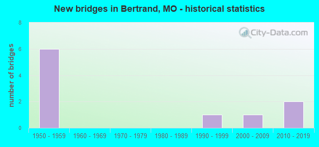
- New bridges - historical statistics
- 61950-1959
- 11990-1999
- 12000-2009
- 22010-2019

- Reconstructed bridges - Historical Statistics
- 11980-1989
- 01990-1999
- 02000-2009
- 02010-2019
- 12020-2022


- Bridge Condition - Deck
- 33.3%Very good
- 33.3%Fair
- 33.3%Poor

- Bridge Condition - Superstructure
- 33.3%Excellent
- 33.3%Satisfactory
- 33.3%Poor

- Bridge Condition - Substructure
- 33.3%Excellent
- 66.7%Good

- Bridge Condition - Channel
- 42.9%Good
- 14.3%Satisfactory
- 42.9%Fair

- Bridge Condition - Culverts
- 60.0%Satisfactory
- 40.0%Fair
Find on map >> Show street view
Structure Number: 15402, Location: S 30 T 27 N R 15 E (Lat: 36.950261, Lng: -89.481381), Route carried "on" structure: County highway 93, Year Built: 1990, Status: Open, Structure Length: 0.76m (2.49ft), Average Daily Traffic: 75 (year 2021), Truck Traffic: 10%, Average Future Daily Traffic: 105 (year 2041), Features Intersected: DRAIN DTCH, Facility Carried by Structure: COUNTY RD 530
Minimum Vertical Clearance: 30+ m (98+ ft), Kilometerpoint: 0.322, Lanes on structure: 2, Owner: County Highway Agency, Approaching Roadway Width: 6.7m (22.0ft), Material/Design: Steel, Design/Construction: Culvert, Number Of Spans In Main Unit: 4, Length of Maximum Span: 1.5m (4.9ft), Curb-To-Curb Width: 6.7m (22.0ft), Out-to-Out Width: 6.7m (22.0ft)
Condition: Channel: Good, Culverts: Fair, Operating Rating: 49.5 metric tons, Method Used To Determine Operating Rating: Allowable Stress (AS), Inventory Rating: 16.2 metric tons, Method Used To Determine Inventory Rating: Allowable Stress (AS), Structural Evaluation: Somewhat better than minimum adequacy, Deck Geometry: Somewhat better than minimum adequacy, Waterway Adequacy: Better than present minimum criteria, Approach Roadway Alignment: Equal to present desirable criteria, Designated Inspection Frequency: Every 24 months, Inspection Date: January 2021
Find on map >> Show street view
Structure Number: 203, Location: S 18 T 26 N R 15 E (Lat: 36.893619, Lng: -89.476825), Route carried "on" structure: Interstate 57, Year Built: 1959, Status: Open, Structure Length: 0.92m (3.02ft), Average Daily Traffic: 16,592 (year 2021), Truck Traffic: 40%, Average Future Daily Traffic: 29,036 (year 2041), Design Load: HS 20, Features Intersected: ASH SLU DTCH
Minimum Vertical Clearance: 30+ m (98+ ft), Kilometerpoint: 30.014, Lanes on structure: 4, Base Highway Network: Yes, Owner: State Highway Agency, Approaching Roadway Width: 39.0m (128.0ft), Skew: 23 degrees, Material/Design: Concrete continuous, Design/Construction: Culvert, Number Of Spans In Main Unit: 2, Length of Maximum Span: 3.7m (12.1ft)
Condition: Channel: Satisfactory, Culverts: Satisfactory, Operating Rating: 65.7 metric tons, Method Used To Determine Operating Rating: Load Factor (LF), Inventory Rating: 39.6 metric tons, Method Used To Determine Inventory Rating: Load Factor (LF), Structural Evaluation: Equal to present minimum criteria, Waterway Adequacy: Equal to present minimum criteria, Approach Roadway Alignment: Equal to present desirable criteria, Designated Inspection Frequency: Every 24 months, Inspection Date: November 2021
Find on map >> Show street view
Structure Number: 204, Location: S 17 T 26 N R 15 E (Lat: 36.900875, Lng: -89.456072), Route carried "on" structure: State highway B, Year Built: 1959, Year Reconstructed: 2020, Status: Open, Structure Length: 7.56m (24.80ft), Average Daily Traffic: 2,164 (year 2021), Truck Traffic: 11%, Average Future Daily Traffic: 3,030 (year 2041), Design Load: H 20, Features Intersected: IS 57
Minimum Vertical Clearance: 30+ m (98+ ft), Kilometerpoint: 0.557, Lanes on structure: 2, Lanes under structure: 4, Owner: State Highway Agency, Approaching Roadway Width: 12.2m (40.0ft), Skew: 2 degrees, Material/Design: Steel continuous, Design/Construction: Stringer/Multi-beam, Number Of Spans In Main Unit: 4, Length of Maximum Span: 21.9m (71.9ft), Curb-To-Curb Width: 8.5m (27.9ft), Out-to-Out Width: 9.6m (31.5ft)
Condition: Deck: Poor, Superstructure: Poor, Substructure: Good, Operating Rating: 39.6 metric tons, Method Used To Determine Operating Rating: Allowable Stress (AS), Inventory Rating: 20.7 metric tons, Method Used To Determine Inventory Rating: Allowable Stress (AS), Structural Evaluation: Meets minimum limits, Deck Geometry: Meets minimum limits, Underclear: Meets minimum limits, Approach Roadway Alignment: Equal to present desirable criteria, Designated Inspection Frequency: Every 12 months, Inspection Date: November 2021, Deck Structure Type: Concrete Cast-file-Place, Wearing Surface/Protective System: Wearing Surface: Monolithic Concrete, Deck Protection: Epoxy Coated Reinforcing
Find on map >> Show street view
Structure Number: 32465, Location: S 27 T 26 N R 15 E (Lat: 36.869639, Lng: -89.411503), Route carried "on" structure: County highway 408, Year Built: 2006, Status: Open, Structure Length: 0.98m (3.22ft), Average Daily Traffic: 45 (year 2021), Truck Traffic: 10%, Average Future Daily Traffic: 56 (year 2041), Features Intersected: DRAIN DTCH
Minimum Vertical Clearance: 30+ m (98+ ft), Kilometerpoint: 0.000, Lanes on structure: 2, Owner: County Highway Agency, Approaching Roadway Width: 7.3m (24.0ft), Material/Design: Steel, Design/Construction: Culvert, Number Of Spans In Main Unit: 3, Length of Maximum Span: 2.7m (8.9ft)
Condition: Channel: Fair, Culverts: Fair, Structural Evaluation: Somewhat better than minimum adequacy, Waterway Adequacy: Equal to present minimum criteria, Approach Roadway Alignment: Equal to present minimum criteria, Designated Inspection Frequency: Every 24 months, Inspection Date: December 2021, Wearing Surface/Protective System: Wearing Surface: Gravel
Find on map >> Show street view
Structure Number: 35594, Location: S 4 T 25 N R 15 E (Lat: 36.847722, Lng: -89.444169), Route carried "on" structure: State highway C, Year Built: 2017, Status: Open, Structure Length: 2.24m (7.35ft), Average Daily Traffic: 700 (year 2021), Truck Traffic: 16%, Average Future Daily Traffic: 980 (year 2041), Features Intersected: LATERAL #4
Minimum Vertical Clearance: 30+ m (98+ ft), Kilometerpoint: 0.972, Lanes on structure: 2, Owner: State Highway Agency, Approaching Roadway Width: 7.9m (25.9ft), Material/Design: Prestressed concrete, Design/Construction: Box Beam or Girders - Single/Spread, Number Of Spans In Main Unit: 3, Length of Maximum Span: 8.5m (27.9ft), Curb-To-Curb Width: 7.9m (25.9ft), Out-to-Out Width: 8.1m (26.6ft)
Condition: Deck: Very good, Superstructure: Excellent, Substructure: Excellent, Channel: Good, Operating Rating: 61.2 metric tons, Method Used To Determine Operating Rating: Load Factor (LF), Inventory Rating: 36.9 metric tons, Method Used To Determine Inventory Rating: Load Factor (LF), Structural Evaluation: Superior to present desirable criteria, Deck Geometry: Somewhat better than minimum adequacy, Waterway Adequacy: Superior to present desirable criteria, Approach Roadway Alignment: Equal to present desirable criteria, Designated Inspection Frequency: Every 24 months, Inspection Date: November 2021, Deck Structure Type: Concrete Cast-file-Place, Wearing Surface/Protective System: Wearing Surface: Monolithic Concrete, Deck Protection: Epoxy Coated Reinforcing
Find on map >> Show street view
Structure Number: 35719, Location: S 31 T 27 N R 14 E (Lat: 36.945031, Lng: -89.483614), Route carried "on" structure: State highway O, Year Built: 2018, Status: Open, Structure Length: 1.78m (5.84ft), Average Daily Traffic: 429 (year 2021), Truck Traffic: 13%, Average Future Daily Traffic: 622 (year 2041), Features Intersected: DRAIN DTCH
Minimum Vertical Clearance: 30+ m (98+ ft), Kilometerpoint: 3.265, Lanes on structure: 2, Owner: State Highway Agency, Approaching Roadway Width: 7.3m (24.0ft), Skew: 3 degrees, Material/Design: Concrete continuous, Design/Construction: Culvert, Number Of Spans In Main Unit: 3, Length of Maximum Span: 4.6m (15.1ft), Out-to-Out Width: 14.6m (47.9ft)
Condition: Channel: Good, Culverts: Satisfactory, Operating Rating: 63.0 metric tons, Method Used To Determine Operating Rating: Load Factor (LF), Inventory Rating: 37.8 metric tons, Method Used To Determine Inventory Rating: Load Factor (LF), Structural Evaluation: Equal to present minimum criteria, Waterway Adequacy: Superior to present desirable criteria, Approach Roadway Alignment: Equal to present desirable criteria, Designated Inspection Frequency: Every 24 months, Inspection Date: December 2020, Deck Structure Type: Concrete Cast-file-Place
Find on map >> Show street view
Structure Number: 6248, Location: S 11 T 26 N R 15 E (Lat: 36.906397, Lng: -89.401628), Route carried "on" structure: Interstate 57, Year Built: 1959, Status: Open, Structure Length: 0.76m (2.49ft), Average Daily Traffic: 18,887 (year 2021), Truck Traffic: 10%, Average Future Daily Traffic: 33,052 (year 2041), Design Load: HS 20, Features Intersected: DRAIN DTCH
Minimum Vertical Clearance: 30+ m (98+ ft), Kilometerpoint: 23.012, Lanes on structure: 4, Base Highway Network: Yes, Owner: State Highway Agency, Approaching Roadway Width: 39.0m (128.0ft), Skew: 20 degrees, Material/Design: Concrete continuous, Design/Construction: Culvert, Number Of Spans In Main Unit: 2, Length of Maximum Span: 3.7m (12.1ft)
Condition: Channel: Fair, Culverts: Satisfactory, Inventory Rating: 59.4 metric tons, Method Used To Determine Inventory Rating: Load Factor (LF), Structural Evaluation: Equal to present minimum criteria, Waterway Adequacy: Equal to present minimum criteria, Approach Roadway Alignment: Equal to present desirable criteria, Designated Inspection Frequency: Every 24 months, Inspection Date: November 2021
Find on map >> Show street view
Structure Number: 7419, Location: S 1 T 26 N R 14 E (Lat: 36.929875, Lng: -89.483572), Route carried "on" structure: State highway O, Year Built: 1957, Year Reconstructed: 1994, Status: Open, Structure Length: 5.67m (18.60ft), Average Daily Traffic: 429 (year 2021), Truck Traffic: 13%, Average Future Daily Traffic: 622 (year 2041), Design Load: H 10, Features Intersected: NORTH CUT DTCH
Minimum Vertical Clearance: 30+ m (98+ ft), Kilometerpoint: 4.942, Lanes on structure: 2, Owner: State Highway Agency, Approaching Roadway Width: 6.1m (20.0ft), Skew: 4 degrees, Material/Design: Steel, Design/Construction: Stringer/Multi-beam, Number Of Spans In Main Unit: 5, Length of Maximum Span: 15.7m (51.5ft), Curb-To-Curb Width: 6.1m (20.0ft), Out-to-Out Width: 6.8m (22.3ft)
Condition: Deck: Fair, Superstructure: Satisfactory, Substructure: Good, Channel: Fair, Operating Rating: 25.2 metric tons, Method Used To Determine Operating Rating: Load Factor (LF), Inventory Rating: 15.3 metric tons, Method Used To Determine Inventory Rating: Load Factor (LF), Structural Evaluation: Meets minimum limits, Deck Geometry: High priority of corrective action, Waterway Adequacy: Equal to present desirable criteria, Approach Roadway Alignment: Equal to present desirable criteria, Length Of Structure Improvement: 0.67m (2.20ft), Designated Inspection Frequency: Every 24 months, Inspection Date: Febuary 2021, Bridge Improvement Cost: $765,000, Roadway Improvement Cost: $77,000, Total Project Cost: $1,148,000 ( Estimate for 2022), Deck Structure Type: Concrete Cast-file-Place, Wearing Surface/Protective System: Wearing Surface: Bituminous, Deck Protection: Internally Sealed
Find on map >> Show street view
Structure Number: 204, Location: S 17 T 26 N R 15 E (Lat: 36.900875, Lng: -89.456072), Route carried "under" structure: Interstate 57, Year Built: 1959, Structure Length: 0. m, Average Daily Traffic: 9,131 (year 2021), Truck Traffic: 44%, Features Intersected: IS 57, Facility Carried by Structure: RT B S
Minimum Vertical Clearance: 4.62m (15.16ft), Kilometerpoint: 7.912, Lanes on structure: 2, Lanes under structure: 2, Material/Design: Steel continuous, Design/Construction: Stringer/Multi-beam, Length of Maximum Span: 21.9m (71.9ft)
Find on map >> Show street view
Structure Number: 204, Location: S 17 T 26 N R 15 E (Lat: 36.900875, Lng: -89.456072), Route carried "under" structure: Interstate 57, Year Built: 1959, Structure Length: 0. m, Average Daily Traffic: 9,683 (year 2021), Truck Traffic: 10%, Features Intersected: IS 57, Facility Carried by Structure: RT B S
Minimum Vertical Clearance: 4.62m (15.16ft), Kilometerpoint: 27.995, Lanes on structure: 2, Lanes under structure: 2, Material/Design: Steel continuous, Design/Construction: Stringer/Multi-beam, Length of Maximum Span: 21.9m (71.9ft)