Bridge Statistics for Berwind, West Virginia (WV)
Condition, Traffic, Stress, Structural Evaluation, Project Costs
- National Bridge Inventory (NBI) Statistics
- 20Number of bridges
- 108ft / 33.0mTotal length
- $3,100,000Total costs
- 12,570Total average daily traffic
- 770Total average daily truck traffic
- National Bridge Inventory (NBI) Registered Bridges for Berwind
- No street view available for this location
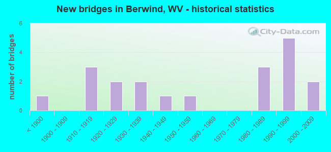
- New bridges - historical statistics
- 1Before 1900
- 31910-1919
- 21920-1929
- 21930-1939
- 11940-1949
- 11950-1959
- 31980-1989
- 51990-1999
- 22000-2009

- Bridge Condition - Deck
- 38.5%Satisfactory
- 38.5%Fair
- 23.1%Poor

- Bridge Condition - Superstructure
- 7.7%Good
- 23.1%Satisfactory
- 53.8%Fair
- 15.4%Poor

- Bridge Condition - Substructure
- 30.8%Satisfactory
- 53.8%Fair
- 15.4%Poor

- Bridge Condition - Channel
- 30.8%Very good
- 46.2%Good
- 7.7%Satisfactory
- 7.7%Fair
- 7.7%Poor
Find on map >> Show street view
Structure Number: 24A063, Location: 0.22 MI N OF CR 9/5 (Lat: 37.254339, Lng: -81.646600), Route carried "on" structure: County highway 900, Year Built: 1986, Status: Open, Structure Length: 3.22m (10.56ft), Average Daily Traffic: 500 (year 2018), Truck Traffic: 6%, Average Future Daily Traffic: 500 (year 2038), Design Load: HS 20, Features Intersected: DRY FORK, Facility Carried by Structure: CR 9
Minimum Vertical Clearance: 30+ m (98+ ft), Kilometerpoint: 6.148, Lanes on structure: 2, Owner: State Highway Agency, Approaching Roadway Width: 7.3m (24.0ft), Skew: 5 degrees, Material/Design: Steel continuous, Design/Construction: Stringer/Multi-beam, Number Of Spans In Main Unit: 2, Length of Maximum Span: 15.2m (49.9ft), Curb-To-Curb Width: 7.6m (24.9ft), Out-to-Out Width: 8.7m (28.5ft)
Condition: Deck: Fair, Superstructure: Good, Substructure: Fair, Channel: Good, Operating Rating: 62.6 metric tons, Method Used To Determine Operating Rating: Load Factor (LF), Inventory Rating: 37.2 metric tons, Method Used To Determine Inventory Rating: Load Factor (LF), Structural Evaluation: Somewhat better than minimum adequacy, Deck Geometry: Meets minimum limits, Waterway Adequacy: Equal to present minimum criteria, Approach Roadway Alignment: Better than present minimum criteria, Designated Inspection Frequency: Every 24 months, Inspection Date: Febuary 2021, Deck Structure Type: Concrete Cast-file-Place, Wearing Surface/Protective System: Deck Protection: Epoxy Coated Reinforcing
Find on map >> Show street view
Structure Number: 24A069, Location: 0.65 MI S OF CR 9/2 (Lat: 37.224961, Lng: -81.634739), Route carried "on" structure: County highway 900, Year Built: 1986, Status: Open, Structure Length: 3.23m (10.60ft), Average Daily Traffic: 350 (year 2018), Truck Traffic: 6%, Average Future Daily Traffic: 350 (year 2038), Design Load: HS 20, Features Intersected: DRY FORK, Facility Carried by Structure: CR 9
Minimum Vertical Clearance: 30+ m (98+ ft), Kilometerpoint: 11.346, Lanes on structure: 2, Owner: State Highway Agency, Approaching Roadway Width: 6.7m (22.0ft), Skew: 4 degrees, Material/Design: Steel continuous, Design/Construction: Stringer/Multi-beam, Number Of Spans In Main Unit: 2, Length of Maximum Span: 15.2m (49.9ft), Curb-To-Curb Width: 7.6m (24.9ft), Out-to-Out Width: 8.7m (28.5ft)
Condition: Deck: Satisfactory, Superstructure: Satisfactory, Substructure: Satisfactory, Channel: Good, Operating Rating: 68.0 metric tons, Method Used To Determine Operating Rating: Load Factor (LF), Inventory Rating: 40.8 metric tons, Method Used To Determine Inventory Rating: Load Factor (LF), Structural Evaluation: Equal to present minimum criteria, Deck Geometry: Somewhat better than minimum adequacy, Waterway Adequacy: Equal to present minimum criteria, Approach Roadway Alignment: Better than present minimum criteria, Designated Inspection Frequency: Every 24 months, Inspection Date: March 2021, Deck Structure Type: Concrete Cast-file-Place, Wearing Surface/Protective System: Wearing Surface: Monolithic Concrete, Deck Protection: Epoxy Coated Reinforcing
Find on map >> Show street view
Structure Number: 24A073, Location: 0.81 MI. S. OF CR. 9 (Lat: 37.206450, Lng: -81.637050), Route carried "on" structure: County highway 906, Year Built: 1925, Status: Posted for load, Structure Length: 1.15m (3.77ft), Average Daily Traffic: 600 (year 2018), Truck Traffic: 6%, Average Future Daily Traffic: 600 (year 2038), Features Intersected: RIGHT FORK, Facility Carried by Structure: COUNTY ROUTE 9/6
Minimum Vertical Clearance: 30+ m (98+ ft), Kilometerpoint: 1.304, Lanes on structure: 2, Owner: State Highway Agency, Approaching Roadway Width: 6.7m (22.0ft), Skew: 4 degrees, Material/Design: Concrete, Design/Construction: Slab, Number Of Spans In Main Unit: 1, Length of Maximum Span: 10.5m (34.4ft), Curb-To-Curb Width: 6.8m (22.3ft), Out-to-Out Width: 7.6m (24.9ft)
Condition: Deck: Poor, Superstructure: Poor, Substructure: Fair, Channel: Satisfactory, Operating Rating: 39.9 metric tons, Method Used To Determine Operating Rating: Field evaluation and documented engineering judgment, Inventory Rating: 18.1 metric tons, Method Used To Determine Inventory Rating: Field evaluation and documented engineering judgment, Structural Evaluation: Meets minimum limits, Deck Geometry: Meets minimum limits, Waterway Adequacy: Equal to present minimum criteria, Approach Roadway Alignment: Better than present minimum criteria, Bridge Posting: Required (Relationship of Operating Rating to Maximum Legal Load: 0.1 - 9.9% below), Length Of Structure Improvement: 1.16m (3.81ft), Designated Inspection Frequency: Every 24 months, Inspection Date: April 2020, Bridge Improvement Cost: $500,000, Roadway Improvement Cost: $50,000, Total Project Cost: $550,000 ( Estimate for 2020), Deck Structure Type: Concrete Cast-file-Place, Wearing Surface/Protective System: Wearing Surface: Bituminous
Find on map >> Show street view
Structure Number: 24A076, Location: 0.04 MI. E. OF CR. 9 (Lat: 37.247700, Lng: -81.640789), Route carried "on" structure: County highway 1100, Year Built: 1985, Status: Open, Structure Length: 3.35m (10.99ft), Average Daily Traffic: 500 (year 2018), Truck Traffic: 6%, Average Future Daily Traffic: 500 (year 2038), Design Load: HS 20, Features Intersected: DRY FORK, Facility Carried by Structure: COUNTY ROUTE 11
Minimum Vertical Clearance: 30+ m (98+ ft), Kilometerpoint: 0.064, Lanes on structure: 2, Owner: State Highway Agency, Approaching Roadway Width: 7.3m (24.0ft), Skew: 1 degrees, Material/Design: Steel continuous, Design/Construction: Stringer/Multi-beam, Number Of Spans In Main Unit: 2, Length of Maximum Span: 16.2m (53.1ft), Curb-To-Curb Width: 7.6m (24.9ft), Out-to-Out Width: 8.7m (28.5ft)
Condition: Deck: Satisfactory, Superstructure: Satisfactory, Substructure: Fair, Channel: Good, Operating Rating: 78.0 metric tons, Method Used To Determine Operating Rating: Load Factor (LF), Inventory Rating: 46.3 metric tons, Method Used To Determine Inventory Rating: Load Factor (LF), Structural Evaluation: Somewhat better than minimum adequacy, Deck Geometry: Meets minimum limits, Waterway Adequacy: Equal to present desirable criteria, Approach Roadway Alignment: Equal to present minimum criteria, Designated Inspection Frequency: Every 24 months, Inspection Date: Febuary 2020, Deck Structure Type: Concrete Cast-file-Place, Wearing Surface/Protective System: Wearing Surface: Monolithic Concrete, Deck Protection: Epoxy Coated Reinforcing
Find on map >> Show street view
Structure Number: 24A233, Location: 0.01 MI N OF CR 9 (Lat: 37.267931, Lng: -81.667289), Route carried "on" structure: County highway 907, Year Built: 1936, Year Reconstructed: 1984, Status: Posted for load, Structure Length: 1.71m (5.61ft), Average Daily Traffic: 20 (year 2019), Truck Traffic: 9%, Average Future Daily Traffic: 29 (year 2039), Features Intersected: DRY FORK, Facility Carried by Structure: CR 9/7
Minimum Vertical Clearance: 30+ m (98+ ft), Kilometerpoint: 0.016, Lanes on structure: 1, Owner: State Highway Agency, Approaching Roadway Width: 3.0m (9.8ft), Material/Design: Steel, Design/Construction: Stringer/Multi-beam, Number Of Spans In Main Unit: 1, Length of Maximum Span: 16.5m (54.1ft), Curb or Sidewalk Widths: Left: 0.2m (0.7ft), Right: 0.2m (0.7ft), Curb-To-Curb Width: 3.3m (10.8ft), Out-to-Out Width: 3.7m (12.1ft)
Condition: Deck: Satisfactory, Superstructure: Fair, Substructure: Poor, Channel: Poor, Operating Rating: 88.9 metric tons, Method Used To Determine Operating Rating: Load Factor (LF), Inventory Rating: 71.7 metric tons, Method Used To Determine Inventory Rating: Load Factor (LF), Structural Evaluation: Meets minimum limits, Deck Geometry: High priority of replacement, Waterway Adequacy: Equal to present minimum criteria, Approach Roadway Alignment: High priority of corrective action, Length Of Structure Improvement: 1.71m (5.61ft), Designated Inspection Frequency: Every 24 months, Underwater Inspection Frequency: Every 12 months, Other Special Inspection Frequency: Every 12 months, Inspection Date: August 2021, Underwater Inspection Date: July 2021, Other Special Inspection Date: August 2021, Bridge Improvement Cost: $450,000, Roadway Improvement Cost: $50,000, Total Project Cost: $500,000 ( Estimate for 2021), Deck Structure Type: Wood or Timber, Wearing Surface/Protective System: Wearing Surface: Bituminous
Find on map >> Show street view
Structure Number: 24A246, Location: 0.01 MILE N. OF CO. 9/2 (Lat: 37.232211, Lng: -81.641939), Route carried "on" structure: County highway 900, Year Built: 1998, Status: Open, Structure Length: 3.19m (10.47ft), Average Daily Traffic: 350 (year 2018), Truck Traffic: 6%, Average Future Daily Traffic: 350 (year 2038), Design Load: HS 25 or greater, Features Intersected: DRY FORK, Facility Carried by Structure: COUNTY ROUTE 9
Minimum Vertical Clearance: 30+ m (98+ ft), Kilometerpoint: 10.284, Lanes on structure: 2, Owner: State Highway Agency, Approaching Roadway Width: 6.1m (20.0ft), Skew: 3 degrees, Material/Design: Prestressed concrete, Design/Construction: Box Beam or Girders - Multiple, Number Of Spans In Main Unit: 1, Length of Maximum Span: 30.5m (100.1ft), Curb-To-Curb Width: 9.3m (30.5ft), Out-to-Out Width: 9.3m (30.5ft)
Condition: Deck: Fair, Superstructure: Fair, Substructure: Fair, Channel: Good, Operating Rating: 88.9 metric tons, Method Used To Determine Operating Rating: Load Factor (LF), Inventory Rating: 78.0 metric tons, Method Used To Determine Inventory Rating: Load Factor (LF), Structural Evaluation: Somewhat better than minimum adequacy, Deck Geometry: Equal to present minimum criteria, Waterway Adequacy: Equal to present minimum criteria, Approach Roadway Alignment: Somewhat better than minimum adequacy, Designated Inspection Frequency: Every 24 months, Inspection Date: December 2020, Deck Structure Type: Concrete Cast-file-Place, Wearing Surface/Protective System: Deck Protection: Epoxy Coated Reinforcing
Find on map >> Show street view
Structure Number: 24A249, Location: 0.01 MI. WEST OF CO 9 (Lat: 37.251961, Lng: -81.648519), Route carried "on" structure: County highway 905, Year Built: 1997, Status: Open, Structure Length: 1.82m (5.97ft), Average Daily Traffic: 200 (year 2018), Truck Traffic: 6%, Average Future Daily Traffic: 200 (year 2038), Design Load: HS 25 or greater, Features Intersected: DRY FORK, Facility Carried by Structure: CO 9/5
Minimum Vertical Clearance: 30+ m (98+ ft), Kilometerpoint: 0.016, Lanes on structure: 2, Owner: State Highway Agency, Approaching Roadway Width: 5.5m (18.0ft), Material/Design: Prestressed concrete, Design/Construction: Box Beam or Girders - Multiple, Number Of Spans In Main Unit: 1, Length of Maximum Span: 17.1m (56.1ft), Curb-To-Curb Width: 6.5m (21.3ft), Out-to-Out Width: 6.6m (21.7ft)
Condition: Deck: Poor, Superstructure: Poor, Substructure: Fair, Channel: Good, Operating Rating: 78.9 metric tons, Method Used To Determine Operating Rating: Load Factor (LF), Inventory Rating: 47.2 metric tons, Method Used To Determine Inventory Rating: Load Factor (LF), Structural Evaluation: Meets minimum limits, Deck Geometry: Meets minimum limits, Waterway Adequacy: Equal to present desirable criteria, Approach Roadway Alignment: Meets minimum limits, Length Of Structure Improvement: 1.82m (5.97ft), Designated Inspection Frequency: Every 24 months, Inspection Date: Febuary 2021, Bridge Improvement Cost: $650,000, Roadway Improvement Cost: $100,000, Total Project Cost: $750,000 ( Estimate for 2021), Deck Structure Type: Other
Find on map >> Show street view
Structure Number: 24A251, Location: 0.33 MILE NORTH OF CO 9/2 (Lat: 37.232961, Lng: -81.637511), Route carried "on" structure: County highway 900, Year Built: 1997, Status: Open, Structure Length: 1.89m (6.20ft), Average Daily Traffic: 350 (year 2018), Truck Traffic: 6%, Average Future Daily Traffic: 350 (year 2038), Design Load: HS 25 or greater, Features Intersected: DRY FORK, Facility Carried by Structure: COUNTY ROUTE 9
Minimum Vertical Clearance: 30+ m (98+ ft), Kilometerpoint: 9.769, Lanes on structure: 2, Owner: State Highway Agency, Approaching Roadway Width: 6.1m (20.0ft), Skew: 3 degrees, Material/Design: Prestressed concrete, Design/Construction: Box Beam or Girders - Multiple, Number Of Spans In Main Unit: 1, Length of Maximum Span: 17.7m (58.1ft), Curb-To-Curb Width: 8.9m (29.2ft), Out-to-Out Width: 9.2m (30.2ft)
Condition: Deck: Satisfactory, Superstructure: Satisfactory, Substructure: Satisfactory, Channel: Very good, Operating Rating: 88.9 metric tons, Method Used To Determine Operating Rating: Load Factor (LF), Inventory Rating: 59.9 metric tons, Method Used To Determine Inventory Rating: Load Factor (LF), Structural Evaluation: Equal to present minimum criteria, Deck Geometry: Equal to present minimum criteria, Waterway Adequacy: Equal to present desirable criteria, Approach Roadway Alignment: Meets minimum limits, Designated Inspection Frequency: Every 24 months, Inspection Date: January 2021, Deck Structure Type: Concrete Cast-file-Place, Wearing Surface/Protective System: Wearing Surface: Monolithic Concrete, Deck Protection: Epoxy Coated Reinforcing
Find on map >> Show street view
Structure Number: 24A266, Location: 0.14 MI N OF CO 11 (Lat: 37.248619, Lng: -81.644481), Route carried "on" structure: County highway 900, Year Built: 1999, Status: Open, Structure Length: 3.18m (10.43ft), Average Daily Traffic: 500 (year 2018), Truck Traffic: 6%, Average Future Daily Traffic: 500 (year 2038), Design Load: HS 25 or greater, Features Intersected: DRY FORK, Facility Carried by Structure: COUNTY ROUTE 9
Minimum Vertical Clearance: 30+ m (98+ ft), Kilometerpoint: 7.145, Lanes on structure: 2, Owner: State Highway Agency, Approaching Roadway Width: 7.3m (24.0ft), Skew: 3 degrees, Material/Design: Prestressed concrete, Design/Construction: Box Beam or Girders - Multiple, Number Of Spans In Main Unit: 1, Length of Maximum Span: 30.5m (100.1ft), Curb-To-Curb Width: 9.3m (30.5ft), Out-to-Out Width: 9.3m (30.5ft)
Condition: Deck: Fair, Superstructure: Fair, Substructure: Satisfactory, Channel: Very good, Operating Rating: 88.9 metric tons, Method Used To Determine Operating Rating: Load Factor (LF), Inventory Rating: 55.3 metric tons, Method Used To Determine Inventory Rating: Load Factor (LF), Structural Evaluation: Somewhat better than minimum adequacy, Deck Geometry: Equal to present minimum criteria, Waterway Adequacy: Equal to present desirable criteria, Approach Roadway Alignment: Better than present minimum criteria, Designated Inspection Frequency: Every 24 months, Inspection Date: January 2020, Deck Structure Type: Other, Wearing Surface/Protective System: Deck Protection: Epoxy Coated Reinforcing
Find on map >> Show street view
Structure Number: 24A271, Location: 0.01 MI S OF CO 9/1 (Lat: 37.269481, Lng: -81.666881), Route carried "on" structure: County highway 900, Year Built: 1995, Status: Open, Structure Length: 2.07m (6.79ft), Average Daily Traffic: 550 (year 2019), Truck Traffic: 9%, Average Future Daily Traffic: 578 (year 2039), Design Load: HS 25 or greater, Features Intersected: DRY FORK, Facility Carried by Structure: COUNTY ROUTE 9
Minimum Vertical Clearance: 30+ m (98+ ft), Kilometerpoint: 3.106, Lanes on structure: 2, Owner: State Highway Agency, Approaching Roadway Width: 7.3m (24.0ft), Material/Design: Prestressed concrete, Design/Construction: Box Beam or Girders - Multiple, Number Of Spans In Main Unit: 1, Length of Maximum Span: 19.5m (64.0ft), Curb or Sidewalk Widths: Left: 1.2m (3.9ft), Right: 0.0m, Curb-To-Curb Width: 7.2m (23.6ft), Out-to-Out Width: 8.4m (27.6ft)
Condition: Deck: Fair, Superstructure: Fair, Substructure: Fair, Channel: Very good, Operating Rating: 76.2 metric tons, Method Used To Determine Operating Rating: Load Factor (LF), Inventory Rating: 45.4 metric tons, Method Used To Determine Inventory Rating: Load Factor (LF), Structural Evaluation: Somewhat better than minimum adequacy, Deck Geometry: Meets minimum limits, Waterway Adequacy: Equal to present desirable criteria, Approach Roadway Alignment: Somewhat better than minimum adequacy, Designated Inspection Frequency: Every 24 months, Inspection Date: November 2021, Deck Structure Type: Other, Wearing Surface/Protective System: Wearing Surface: Bituminous, Deck Protection: Epoxy Coated Reinforcing
Find on map >> Show street view
Structure Number: 24A272, Location: 0.01 MI. S. OF CR.9 (Lat: 37.215589, Lng: -81.631569), Route carried "on" structure: County highway 906, Year Built: 1928, Status: Posted for load, Structure Length: 2.49m (8.17ft), Average Daily Traffic: 600 (year 2018), Truck Traffic: 6%, Average Future Daily Traffic: 600 (year 2038), Features Intersected: DRY FORK, Facility Carried by Structure: COUNTY ROUTE 9/6
Minimum Vertical Clearance: 30+ m (98+ ft), Kilometerpoint: 0.016, Lanes on structure: 2, Owner: State Highway Agency, Approaching Roadway Width: 6.7m (22.0ft), Material/Design: Concrete continuous, Design/Construction: Stringer/Multi-beam, Number Of Spans In Main Unit: 1, Number Of Approach Spans: 2, Length of Maximum Span: 12.2m (40.0ft), Curb or Sidewalk Widths: Left: 0.1m (0.3ft), Right: 0.1m (0.3ft), Curb-To-Curb Width: 4.9m (16.1ft), Out-to-Out Width: 5.6m (18.4ft)
Condition: Deck: Poor, Superstructure: Fair, Substructure: Poor, Channel: Fair, Operating Rating: 47.2 metric tons, Method Used To Determine Operating Rating: Field evaluation and documented engineering judgment, Inventory Rating: 21.8 metric tons, Method Used To Determine Inventory Rating: Field evaluation and documented engineering judgment, Structural Evaluation: Meets minimum limits, Deck Geometry: High priority of replacement, Waterway Adequacy: Somewhat better than minimum adequacy, Approach Roadway Alignment: High priority of corrective action, Length Of Structure Improvement: 2.50m (8.20ft), Designated Inspection Frequency: Every 24 months, Other Special Inspection Frequency: Every 12 months, Inspection Date: Febuary 2020, Other Special Inspection Date: Febuary 2021, Bridge Improvement Cost: $1,250,000, Roadway Improvement Cost: $50,000, Total Project Cost: $1,300,000 ( Estimate for 2020), Deck Structure Type: Concrete Cast-file-Place, Wearing Surface/Protective System: Wearing Surface: Bituminous
Find on map >> Show street view
Structure Number: 24A29, Location: 0.59 MI SOUTH OF CO 9/4 (Lat: 37.260381, Lng: -81.658411), Route carried "on" structure: County highway 900, Year Built: 2000, Status: Open, Structure Length: 2.56m (8.40ft), Average Daily Traffic: 500 (year 2018), Truck Traffic: 6%, Average Future Daily Traffic: 500 (year 2038), Design Load: HS 25 or greater, Features Intersected: DRY FORK, Facility Carried by Structure: COUNTY ROUTE 9
Minimum Vertical Clearance: 30+ m (98+ ft), Kilometerpoint: 4.474, Lanes on structure: 2, Owner: State Highway Agency, Approaching Roadway Width: 7.3m (24.0ft), Skew: 3 degrees, Material/Design: Prestressed concrete, Design/Construction: Box Beam or Girders - Multiple, Number Of Spans In Main Unit: 1, Length of Maximum Span: 24.4m (80.1ft), Curb-To-Curb Width: 9.2m (30.2ft), Out-to-Out Width: 9.3m (30.5ft)
Condition: Deck: Fair, Superstructure: Fair, Substructure: Fair, Channel: Good, Operating Rating: 87.1 metric tons, Method Used To Determine Operating Rating: Load Factor (LF), Inventory Rating: 52.6 metric tons, Method Used To Determine Inventory Rating: Load Factor (LF), Structural Evaluation: Somewhat better than minimum adequacy, Deck Geometry: Equal to present minimum criteria, Waterway Adequacy: Equal to present desirable criteria, Approach Roadway Alignment: Meets minimum limits, Designated Inspection Frequency: Every 24 months, Inspection Date: April 2020, Deck Structure Type: Other, Wearing Surface/Protective System: Deck Protection: Epoxy Coated Reinforcing
Find on map >> Show street view
Structure Number: 24A298, Location: 0.59 MI SOUTH OF WV 16 (Lat: 37.281761, Lng: -81.667400), Route carried "on" structure: County highway 900, Year Built: 2002, Status: Open, Structure Length: 3.16m (10.37ft), Average Daily Traffic: 1,500 (year 2018), Truck Traffic: 6%, Average Future Daily Traffic: 1,500 (year 2038), Design Load: HS 25 or greater, Features Intersected: DRY FORK, Facility Carried by Structure: CO 9
Minimum Vertical Clearance: 30+ m (98+ ft), Kilometerpoint: 0.950, Lanes on structure: 2, Owner: State Highway Agency, Approaching Roadway Width: 7.3m (24.0ft), Material/Design: Prestressed concrete, Design/Construction: Box Beam or Girders - Multiple, Number Of Spans In Main Unit: 1, Length of Maximum Span: 30.5m (100.1ft), Curb-To-Curb Width: 9.2m (30.2ft), Out-to-Out Width: 9.2m (30.2ft)
Condition: Deck: Satisfactory, Superstructure: Fair, Substructure: Satisfactory, Channel: Very good, Operating Rating: 88.9 metric tons, Method Used To Determine Operating Rating: Load Factor (LF), Inventory Rating: 76.2 metric tons, Method Used To Determine Inventory Rating: Load Factor (LF), Structural Evaluation: Somewhat better than minimum adequacy, Deck Geometry: Somewhat better than minimum adequacy, Waterway Adequacy: Equal to present desirable criteria, Approach Roadway Alignment: Meets minimum limits, Designated Inspection Frequency: Every 24 months, Inspection Date: June 2020, Deck Structure Type: Concrete Cast-file-Place, Wearing Surface/Protective System: Wearing Surface: Integral Concrete, Deck Protection: Epoxy Coated Reinforcing
Find on map >> Show street view
Structure Number: 24A057, Location: 0.32 MI S OF WV 16 (Lat: 37.281689, Lng: -81.663381), Route carried "under" structure: County highway 900, Year Built: 1890, Structure Length: 0. m, Average Daily Traffic: 1,500 (year 2018), Truck Traffic: 6%, Features Intersected: NORFOLK SOUTHERN RW, Facility Carried by Structure: N S RAILWAY
Minimum Vertical Clearance: 3.45m (11.32ft), Kilometerpoint: 0.515, Lanes under structure: 2, Material/Design: Steel, Design/Construction: Stringer/Multi-beam, Length of Maximum Span: 19.1m (62.7ft)
Find on map >> Show street view
Structure Number: 24A058, Location: 0.40 MI S OF WV 16 (Lat: 37.281219, Lng: -81.664250), Route carried "under" structure: County highway 900, Year Built: 1930, Structure Length: 0. m, Average Daily Traffic: 1,500 (year 2018), Truck Traffic: 6%, Features Intersected: NORFOLK SOUTHERN RW, Facility Carried by Structure: N S RAILWAY
Minimum Vertical Clearance: 3.68m (12.07ft), Kilometerpoint: 0.644, Lanes under structure: 2, Material/Design: Steel, Design/Construction: Stringer/Multi-beam, Length of Maximum Span: 14.8m (48.6ft)
Find on map >> Show street view
Structure Number: 24A059, Location: 0.47 MI S OF WV 16 (Lat: 37.281150, Lng: -81.665681), Route carried "under" structure: County highway 900, Year Built: 1945, Structure Length: 0. m, Average Daily Traffic: 1,500 (year 2018), Truck Traffic: 6%, Features Intersected: NORFOLK SOUTHERN RW, Facility Carried by Structure: NS RAILWAY
Minimum Vertical Clearance: 6.10m (20.01ft), Kilometerpoint: 0.756, Lanes under structure: 2, Material/Design: Steel, Design/Construction: Truss - Thru, Length of Maximum Span: 38.1m (125.0ft)
Find on map >> Show street view
Structure Number: 24A065, Location: 0.88 MI N OF CR 9/2 (Lat: 37.237061, Lng: -81.638869), Route carried "under" structure: County highway 900, Year Built: 1911, Structure Length: 0. m, Average Daily Traffic: 350 (year 2018), Truck Traffic: 6%, Features Intersected: NORFOLK SOUTHERN, Facility Carried by Structure: NS RAILWAY
Minimum Vertical Clearance: 6.15m (20.18ft), Kilometerpoint: 8.884, Lanes under structure: 2, Material/Design: Steel, Design/Construction: Stringer/Multi-beam, Length of Maximum Span: 17.7m (58.1ft)
Find on map >> Show street view
Structure Number: 24A067, Location: 0.21 MI N OF CR 9/2 (Lat: 37.233331, Lng: -81.639639), Route carried "under" structure: County highway 900, Year Built: 1911, Structure Length: 0. m, Average Daily Traffic: 350 (year 2018), Truck Traffic: 6%, Features Intersected: NORFOLK SOUTHERN RW, Facility Carried by Structure: NS RAILWAY
Minimum Vertical Clearance: 4.50m (14.76ft), Kilometerpoint: 9.962, Lanes under structure: 2, Material/Design: Steel, Design/Construction: Stringer/Multi-beam, Length of Maximum Span: 17.7m (58.1ft)
Find on map >> Show street view
Structure Number: 24A07, Location: 0.47 MI N OF CR 9/6 (Lat: 37.221000, Lng: -81.633139), Route carried "under" structure: County highway 900, Year Built: 1911, Structure Length: 0. m, Average Daily Traffic: 350 (year 2018), Truck Traffic: 6%, Features Intersected: NORFOLK SOUTHERN RR, Facility Carried by Structure: NS RAILWAY
Minimum Vertical Clearance: 7.11m (23.33ft), Kilometerpoint: 11.909, Lanes under structure: 2, Material/Design: Steel, Design/Construction: Stringer/Multi-beam, Length of Maximum Span: 18.0m (59.1ft)
Find on map >> Show street view
Structure Number: 24A077, Location: 0.08 MI E OF CR 9 (Lat: 37.247869, Lng: -81.639689), Route carried "under" structure: County highway 1100, Year Built: 1954, Structure Length: 0. m, Average Daily Traffic: 500 (year 2018), Truck Traffic: 6%, Features Intersected: NORFOLK SOUTHERN RR, Facility Carried by Structure: NS RAILWAY
Minimum Vertical Clearance: 3.79m (12.43ft), Kilometerpoint: 0.129, Lanes under structure: 2, Material/Design: Steel, Design/Construction: Stringer/Multi-beam, Length of Maximum Span: 8.5m (27.9ft)