Bridge Statistics for Bethel, Pennsylvania (PA)
Condition, Traffic, Stress, Structural Evaluation, Project Costs
- National Bridge Inventory (NBI) Statistics
- 16Number of bridges
- 75ft / 23.1mTotal length
- $1,151,000Total costs
- 126,505Total average daily traffic
- 45,720Total average daily truck traffic
- National Bridge Inventory (NBI) Registered Bridges for Bethel
- No street view available for this location
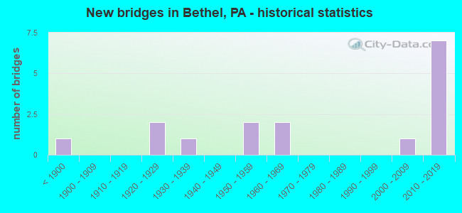
- New bridges - historical statistics
- 1Before 1900
- 21920-1929
- 11930-1939
- 21950-1959
- 21960-1969
- 12000-2009
- 72010-2019
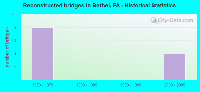
- Reconstructed bridges - Historical Statistics
- 21970-1979
- 01980-1989
- 01990-1999
- 12000-2009
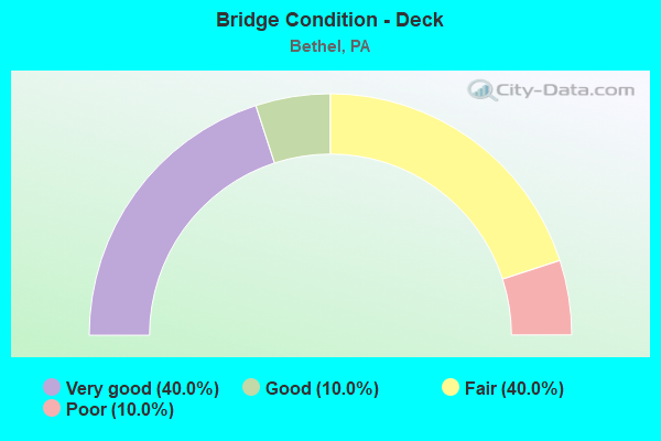
- Bridge Condition - Deck
- 40.0%Very good
- 10.0%Good
- 40.0%Fair
- 10.0%Poor
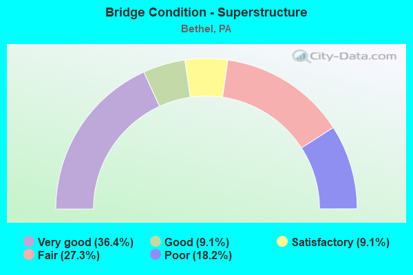
- Bridge Condition - Superstructure
- 36.4%Very good
- 9.1%Good
- 9.1%Satisfactory
- 27.3%Fair
- 18.2%Poor
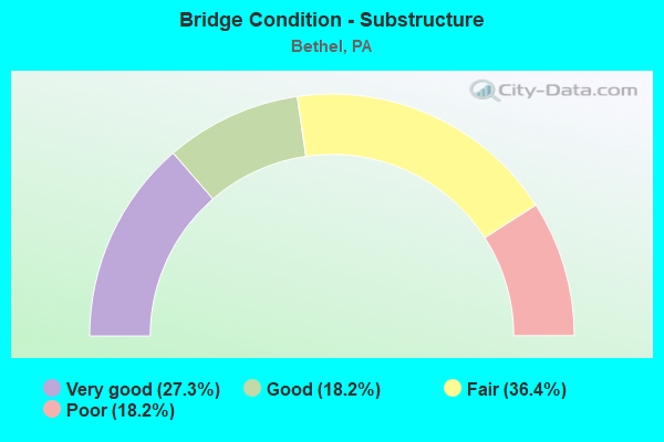
- Bridge Condition - Substructure
- 27.3%Very good
- 18.2%Good
- 36.4%Fair
- 18.2%Poor
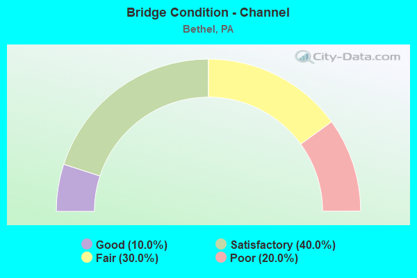
- Bridge Condition - Channel
- 10.0%Good
- 40.0%Satisfactory
- 30.0%Fair
- 20.0%Poor
Find on map >> Show street view
Structure Number: 463, Location: 1 MI.E.OF BETHEL (Lat: 40.479997, Lng: -76.274289), Route carried "on" structure: Interstate 78, Year Built: 1950, Status: Open, Structure Length: 0.64m (2.10ft), Average Daily Traffic: 35,480 (year 2021), Truck Traffic: 41%, Average Future Daily Traffic: 44,925 (year 2032), Design Load: HS 20+Mod, Features Intersected: MILL CREEK
Minimum Vertical Clearance: 30+ m (98+ ft), Kilometerpoint: 9.085, Lanes on structure: 4, Base Highway Network: Yes, Owner: State Highway Agency, Approaching Roadway Width: 28.0m (91.9ft), Skew: 30 degrees, Material/Design: Concrete, Design/Construction: Culvert, Number Of Spans In Main Unit: 1, Length of Maximum Span: 6.4m (21.0ft)
Condition: Channel: Satisfactory, Culverts: Fair, Operating Rating: 89.8 metric tons, Method Used To Determine Operating Rating: Field evaluation and documented engineering judgment, Inventory Rating: 89.8 metric tons, Method Used To Determine Inventory Rating: Field evaluation and documented engineering judgment, Structural Evaluation: Somewhat better than minimum adequacy, Waterway Adequacy: Superior to present desirable criteria, Approach Roadway Alignment: Equal to present desirable criteria, Length Of Structure Improvement: 1.20m (3.94ft), Designated Inspection Frequency: Every 24 months, Inspection Date: June 2021
Find on map >> Show street view
Structure Number: 4878, Location: 2 MI.S.OF BETHEL (Lat: 40.457414, Lng: -76.288594), Route carried "on" structure: State highway 501, Year Built: 1928, Year Reconstructed: 1981, Status: Open, Structure Length: 0.76m (2.49ft), Average Daily Traffic: 6,417 (year 2020), Truck Traffic: 18%, Average Future Daily Traffic: 8,028 (year 2032), Design Load: HS 20, Features Intersected: TRIB.SWATARA CREEK
Minimum Vertical Clearance: 30+ m (98+ ft), Kilometerpoint: 6.268, Lanes on structure: 2, Base Highway Network: Yes, Owner: State Highway Agency, Approaching Roadway Width: 10.1m (33.1ft), Material/Design: Concrete, Design/Construction: Tee Beam, Number Of Spans In Main Unit: 1, Length of Maximum Span: 7.3m (24.0ft), Curb-To-Curb Width: 9.8m (32.2ft), Out-to-Out Width: 10.8m (35.4ft)
Condition: Deck: Fair, Superstructure: Fair, Substructure: Fair, Channel: Poor, Operating Rating: 76.2 metric tons, Method Used To Determine Operating Rating: Load Factor (LF), Inventory Rating: 45.4 metric tons, Method Used To Determine Inventory Rating: Load Factor (LF), Structural Evaluation: Somewhat better than minimum adequacy, Deck Geometry: Meets minimum limits, Waterway Adequacy: Equal to present minimum criteria, Approach Roadway Alignment: Equal to present desirable criteria, Length Of Structure Improvement: 1.50m (4.92ft), Designated Inspection Frequency: Every 24 months, Inspection Date: Febuary 2020, Deck Structure Type: Concrete Cast-file-Place, Wearing Surface/Protective System: Wearing Surface: Integral Concrete, Membrane: Epoxy, Deck Protection: Epoxy Coated Reinforcing
Find on map >> Show street view
Structure Number: 5328, Location: 1 MI. SE OF BETHEL (Lat: 40.461336, Lng: -76.280589), Route carried "on" structure: City street , Year Built: 2006, Status: Open, Structure Length: 1.68m (5.51ft), Average Daily Traffic: 1,814 (year 2017), Truck Traffic: 2%, Average Future Daily Traffic: 2,902 (year 2033), Features Intersected: LITTLE SWATARA CREEK, Facility Carried by Structure: SALEM ROAD
Minimum Vertical Clearance: 30+ m (98+ ft), Kilometerpoint: 0.000, Lanes on structure: 1, Owner: County Highway Agency, Approaching Roadway Width: 4.6m (15.1ft), Material/Design: Masonry, Design/Construction: Arch - Deck, Number Of Spans In Main Unit: 3, Length of Maximum Span: 4.6m (15.1ft), Curb-To-Curb Width: 4.4m (14.4ft), Out-to-Out Width: 5.6m (18.4ft)
Condition: Superstructure: Satisfactory, Substructure: Fair, Channel: Fair, Operating Rating: 49.0 metric tons, Method Used To Determine Operating Rating: Field evaluation and documented engineering judgment, Inventory Rating: 32.7 metric tons, Method Used To Determine Inventory Rating: Field evaluation and documented engineering judgment, Structural Evaluation: Somewhat better than minimum adequacy, Deck Geometry: High priority of replacement, Waterway Adequacy: Equal to present minimum criteria, Approach Roadway Alignment: Equal to present desirable criteria, Length Of Structure Improvement: 2.00m (6.56ft), Designated Inspection Frequency: Every 24 months, Other Special Inspection Frequency: Every 12 months, Inspection Date: April 2020, Other Special Inspection Date: April 2021, Bridge Improvement Cost: $28,000, Roadway Improvement Cost: $83,000, Total Project Cost: $380,000
Find on map >> Show street view
Structure Number: 533, Location: SHIKELLAMY BRIDGE (Lat: 40.472817, Lng: -76.263286), Route carried "on" structure: ServiceCity street , Year Built: 1966, Status: Posted for load, Structure Length: 1.68m (5.51ft), Average Daily Traffic: 447 (year 1985), Truck Traffic: 1%, Average Future Daily Traffic: 1,300 (year 2030), Design Load: HS 20, Features Intersected: LITTLE SWATARA CREEK, Facility Carried by Structure: AIRPORT RD
Minimum Vertical Clearance: 30+ m (98+ ft), Kilometerpoint: 0.000, Lanes on structure: 2, Owner: Town or Township Highway Agency, Approaching Roadway Width: 7.0m (23.0ft), Skew: 3 degrees, Material/Design: Prestressed concrete, Design/Construction: Box Beam or Girders - Multiple, Number Of Spans In Main Unit: 1, Length of Maximum Span: 15.8m (51.8ft), Curb or Sidewalk Widths: Left: 0.5m (1.6ft), Right: 0.5m (1.6ft), Curb-To-Curb Width: 9.8m (32.2ft), Out-to-Out Width: 11.6m (38.1ft)
Condition: Deck: Poor, Superstructure: Poor, Substructure: Good, Channel: Satisfactory, Operating Rating: 49.9 metric tons, Method Used To Determine Operating Rating: Load Factor (LF), Inventory Rating: 21.8 metric tons, Method Used To Determine Inventory Rating: Load Factor (LF), Structural Evaluation: Meets minimum limits, Deck Geometry: Equal to present minimum criteria, Waterway Adequacy: Equal to present minimum criteria, Approach Roadway Alignment: Equal to present desirable criteria, Length Of Structure Improvement: 1.70m (5.58ft), Designated Inspection Frequency: Every 24 months, Other Special Inspection Frequency: Every 12 months, Inspection Date: September 2020, Other Special Inspection Date: September 2021, Deck Structure Type: Other, Wearing Surface/Protective System: Wearing Surface: Bituminous
Find on map >> Show street view
Structure Number: 5333, Location: 1 MILE EAST OF BETHEL (Lat: 40.476839, Lng: -76.270653), Route carried "on" structure: Business City street , Year Built: 1928, Status: Open, Structure Length: 1.04m (3.41ft), Average Daily Traffic: 1,733 (year 1985), Truck Traffic: 1%, Average Future Daily Traffic: 2,426 (year 2005), Features Intersected: MILL CREEK, Facility Carried by Structure: OLD ROUTE 22
Minimum Vertical Clearance: 30+ m (98+ ft), Kilometerpoint: 0.000, Lanes on structure: 2, Owner: Town or Township Highway Agency, Approaching Roadway Width: 6.7m (22.0ft), Material/Design: Concrete, Design/Construction: Tee Beam, Number Of Spans In Main Unit: 1, Length of Maximum Span: 9.1m (29.9ft), Curb-To-Curb Width: 7.2m (23.6ft), Out-to-Out Width: 8.0m (26.2ft)
Condition: Deck: Fair, Superstructure: Fair, Substructure: Poor, Channel: Fair, Operating Rating: 73.5 metric tons, Method Used To Determine Operating Rating: Field evaluation and documented engineering judgment, Inventory Rating: 43.5 metric tons, Method Used To Determine Inventory Rating: Field evaluation and documented engineering judgment, Structural Evaluation: Meets minimum limits, Deck Geometry: High priority of corrective action, Waterway Adequacy: Equal to present minimum criteria, Approach Roadway Alignment: Equal to present desirable criteria, Length Of Structure Improvement: 1.70m (5.58ft), Designated Inspection Frequency: Every 24 months, Inspection Date: September 2021, Bridge Improvement Cost: $3,000, Roadway Improvement Cost: $9,000, Total Project Cost: $43,000, Deck Structure Type: Concrete Cast-file-Place, Wearing Surface/Protective System: Wearing Surface: Bituminous
Find on map >> Show street view
Structure Number: 5336, Location: EAST OF BETHEL,N.OF T721 (Lat: 40.477631, Lng: -76.285819), Route carried "on" structure: ServiceCity street , Year Built: 1950, Status: Open, Structure Length: 0.67m (2.20ft), Average Daily Traffic: 93 (year 1985), Average Future Daily Traffic: 130 (year 2005), Design Load: HS 20, Features Intersected: TRIB TO LITTLE SWATARA, Facility Carried by Structure: LEGION DR
Minimum Vertical Clearance: 30+ m (98+ ft), Kilometerpoint: 0.000, Lanes on structure: 2, Owner: Town or Township Highway Agency, Approaching Roadway Width: 4.9m (16.1ft), Skew: 3 degrees, Material/Design: Concrete, Design/Construction: Tee Beam, Number Of Spans In Main Unit: 1, Length of Maximum Span: 6.1m (20.0ft), Curb or Sidewalk Widths: Left: 0.3m (1.0ft), Right: 0.3m (1.0ft), Curb-To-Curb Width: 7.3m (24.0ft), Out-to-Out Width: 8.4m (27.6ft)
Condition: Deck: Good, Superstructure: Good, Substructure: Poor, Channel: Fair, Operating Rating: 81.6 metric tons, Method Used To Determine Operating Rating: Field evaluation and documented engineering judgment, Inventory Rating: 49.0 metric tons, Method Used To Determine Inventory Rating: Field evaluation and documented engineering judgment, Structural Evaluation: Meets minimum limits, Deck Geometry: Equal to present minimum criteria, Waterway Adequacy: Better than present minimum criteria, Approach Roadway Alignment: Equal to present minimum criteria, Length Of Structure Improvement: 0.70m (2.30ft), Designated Inspection Frequency: Every 24 months, Inspection Date: September 2021, Bridge Improvement Cost: $5,000, Roadway Improvement Cost: $39,000, Total Project Cost: $65,000, Deck Structure Type: Concrete Cast-file-Place, Wearing Surface/Protective System: Wearing Surface: Bituminous
Find on map >> Show street view
Structure Number: 5337, Location: 1.3 MI E OF PA 501 (Lat: 40.486906, Lng: -76.276103), Route carried "on" structure: City street , Year Built: 1960, Status: Open, Structure Length: 0.70m (2.30ft), Average Daily Traffic: 330 (year 1977), Truck Traffic: 1%, Average Future Daily Traffic: 462 (year 2007), Design Load: HS 20, Features Intersected: MILL CREEK, Facility Carried by Structure: SCHUBERT RD
Minimum Vertical Clearance: 30+ m (98+ ft), Kilometerpoint: 0.000, Lanes on structure: 2, Owner: Town or Township Highway Agency, Approaching Roadway Width: 5.5m (18.0ft), Skew: 3 degrees, Material/Design: Concrete, Design/Construction: Slab, Number Of Spans In Main Unit: 1, Length of Maximum Span: 6.1m (20.0ft), Curb or Sidewalk Widths: Left: 0.4m (1.3ft), Right: 0.4m (1.3ft), Curb-To-Curb Width: 9.0m (29.5ft), Out-to-Out Width: 10.8m (35.4ft)
Condition: Deck: Fair, Superstructure: Fair, Substructure: Fair, Channel: Satisfactory, Operating Rating: 75.3 metric tons, Method Used To Determine Operating Rating: Field evaluation and documented engineering judgment, Inventory Rating: 44.5 metric tons, Method Used To Determine Inventory Rating: Field evaluation and documented engineering judgment, Structural Evaluation: Somewhat better than minimum adequacy, Deck Geometry: Equal to present minimum criteria, Waterway Adequacy: Better than present minimum criteria, Approach Roadway Alignment: Equal to present desirable criteria, Length Of Structure Improvement: 1.30m (4.27ft), Designated Inspection Frequency: Every 24 months, Inspection Date: September 2021, Wearing Surface/Protective System: Wearing Surface: Monolithic Concrete
Find on map >> Show street view
Structure Number: 30708, Location: VILLAGE OF ROCK (Lat: 40.543639, Lng: -76.313300), Route carried "on" structure: State highway 895, Year Built: 1937, Year Reconstructed: 1979, Status: Posted for load-capacity, Structure Length: 2.44m (8.01ft), Average Daily Traffic: 1,044 (year 2020), Truck Traffic: 10%, Average Future Daily Traffic: 1,322 (year 2032), Design Load: HS 20, Features Intersected: LITTLE SWATARA CREEK
Minimum Vertical Clearance: 30+ m (98+ ft), Kilometerpoint: 6.333, Lanes on structure: 2, Owner: State Highway Agency, Approaching Roadway Width: 7.0m (23.0ft), Skew: 3 degrees, Material/Design: Concrete, Design/Construction: Tee Beam, Number Of Spans In Main Unit: 2, Length of Maximum Span: 11.6m (38.1ft), Curb or Sidewalk Widths: Left: 0.2m (0.7ft), Right: 0.2m (0.7ft), Curb-To-Curb Width: 7.1m (23.3ft), Out-to-Out Width: 7.9m (25.9ft)
Condition: Deck: Fair, Superstructure: Poor, Substructure: Fair, Channel: Poor, Operating Rating: 46.3 metric tons, Method Used To Determine Operating Rating: Allowable Stress (AS), Inventory Rating: 22.7 metric tons, Method Used To Determine Inventory Rating: Allowable Stress (AS), Structural Evaluation: Meets minimum limits, Deck Geometry: High priority of corrective action, Waterway Adequacy: Better than present minimum criteria, Approach Roadway Alignment: Equal to present desirable criteria, Length Of Structure Improvement: 3.20m (10.50ft), Designated Inspection Frequency: Every 24 months, Other Special Inspection Frequency: Every 12 months, Inspection Date: August 2021, Other Special Inspection Date: August 2021, Bridge Improvement Cost: $29,000, Roadway Improvement Cost: $86,000, Total Project Cost: $393,000, Deck Structure Type: Concrete Cast-file-Place, Wearing Surface/Protective System: Wearing Surface: Bituminous
Find on map >> Show street view
Structure Number: 30956, Location: 0.1 MI NORTH OF SR 895 (Lat: 40.544694, Lng: -76.295003), Route carried "on" structure: City street , Year Built: 1860, Year Reconstructed: 2014, Status: Open, Structure Length: 1.52m (4.99ft), Average Daily Traffic: 50 (year 2015), Average Future Daily Traffic: 450 (year 2035), Design Load: HS 20, Features Intersected: LOWER LITTLE SWATARA CR, Facility Carried by Structure: NEWSWANGER RD
Minimum Vertical Clearance: 3.20m (10.50ft), Kilometerpoint: 0.000, Lanes on structure: 1, Owner: County Highway Agency, Approaching Roadway Width: 4.3m (14.1ft), Material/Design: Steel, Design/Construction: Stringer/Multi-beam, Number Of Spans In Main Unit: 1, Length of Maximum Span: 14.0m (45.9ft), Curb-To-Curb Width: 4.5m (14.8ft), Out-to-Out Width: 4.9m (16.1ft)
Condition: Deck: Very good, Superstructure: Very good, Substructure: Very good, Channel: Satisfactory, Operating Rating: 49.9 metric tons, Method Used To Determine Operating Rating: Allowable Stress (AS), Inventory Rating: 37.2 metric tons, Method Used To Determine Inventory Rating: Allowable Stress (AS), Structural Evaluation: Equal to present desirable criteria, Deck Geometry: High priority of replacement, Waterway Adequacy: Equal to present minimum criteria, Approach Roadway Alignment: Meets minimum limits, Length Of Structure Improvement: 1.80m (5.91ft), Designated Inspection Frequency: Every 24 months, Inspection Date: December 2020, Bridge Improvement Cost: $20,000, Roadway Improvement Cost: $59,000, Total Project Cost: $270,000, Deck Structure Type: Wood or Timber, Wearing Surface/Protective System: Wearing Surface: Wood or Timber
Find on map >> Show street view
Structure Number: 48163, Location: I-78 PA501 INTERCHANGE (Lat: 40.476375, Lng: -76.294781), Route carried "on" structure: State highway 501, Year Built: 2013, Status: Open, Structure Length: 3.54m (11.61ft), Average Daily Traffic: 3,830 (year 2021), Truck Traffic: 9%, Average Future Daily Traffic: 4,220 (year 2034), Design Load: HL 93, Features Intersected: I-78
Minimum Vertical Clearance: 30+ m (98+ ft), Kilometerpoint: 8.943, Lanes on structure: 2, Lanes under structure: 4, Owner: State Highway Agency, Approaching Roadway Width: 12.2m (40.0ft), Material/Design: Prestressed concrete, Design/Construction: Stringer/Multi-beam, Number Of Spans In Main Unit: 1, Length of Maximum Span: 35.1m (115.2ft), Curb or Sidewalk Widths: Left: 0.0m, Right: 2.0m (6.6ft), Curb-To-Curb Width: 14.6m (47.9ft), Out-to-Out Width: 17.5m (57.4ft)
Condition: Deck: Very good, Superstructure: Very good, Substructure: Very good, Operating Rating: 62.2 metric tons, Method Used To Determine Operating Rating: Assigned ratings based on Load and Resistance Factor Design (LRFD) reported by rating factor (RF) using HL93 loadings, Inventory Rating: 33.7 metric tons, Method Used To Determine Inventory Rating: Assigned ratings based on Load and Resistance Factor Design (LRFD) reported by rating factor (RF) using HL93 loadings, Structural Evaluation: Equal to present desirable criteria, Deck Geometry: Superior to present desirable criteria, Underclear: Equal to present minimum criteria, Approach Roadway Alignment: Better than present minimum criteria, Designated Inspection Frequency: Every 48 months, Inspection Date: October 2019, Deck Structure Type: Concrete Cast-file-Place, Wearing Surface/Protective System: Wearing Surface: Monolithic Concrete, Deck Protection: Epoxy Coated Reinforcing
Find on map >> Show street view
Structure Number: 52738, Location: 0.2 MI.E.OF PA501 (Lat: 40.458667, Lng: -76.283361), Route carried "on" structure: State highway , Year Built: 2015, Status: Open, Structure Length: 4.75m (15.58ft), Average Daily Traffic: 4,041 (year 2020), Truck Traffic: 11%, Average Future Daily Traffic: 4,154 (year 2034), Design Load: HL 93, Features Intersected: LITTLE SWATARA CREEK, Facility Carried by Structure: SR 4008 (LR 06007)
Minimum Vertical Clearance: 30+ m (98+ ft), Kilometerpoint: 0.000, Lanes on structure: 2, Owner: State Highway Agency, Approaching Roadway Width: 9.4m (30.8ft), Skew: 2 degrees, Material/Design: Prestressed concrete, Design/Construction: Box Beam or Girders - Single/Spread, Number Of Spans In Main Unit: 2, Length of Maximum Span: 22.9m (75.1ft), Curb or Sidewalk Widths: Left: 0.2m (0.7ft), Right: 0.2m (0.7ft), Curb-To-Curb Width: 9.1m (29.9ft), Out-to-Out Width: 10.2m (33.5ft)
Condition: Deck: Very good, Superstructure: Very good, Substructure: Good, Channel: Good, Operating Rating: 59.6 metric tons, Method Used To Determine Operating Rating: Assigned ratings based on Load and Resistance Factor Design (LRFD) reported by rating factor (RF) using HL93 loadings, Inventory Rating: 37.6 metric tons, Method Used To Determine Inventory Rating: Assigned ratings based on Load and Resistance Factor Design (LRFD) reported by rating factor (RF) using HL93 loadings, Structural Evaluation: Better than present minimum criteria, Deck Geometry: Meets minimum limits, Waterway Adequacy: Superior to present desirable criteria, Approach Roadway Alignment: Equal to present desirable criteria, Designated Inspection Frequency: Every 48 months, Inspection Date: November 2019, Deck Structure Type: Concrete Cast-file-Place, Wearing Surface/Protective System: Wearing Surface: Monolithic Concrete, Deck Protection: Epoxy Coated Reinforcing
Find on map >> Show street view
Structure Number: 5458, Location: Airport Rd Over I-78 (Lat: 40.481667, Lng: -76.266667), Route carried "on" structure: State highway , Year Built: 2018, Status: Open, Structure Length: 3.69m (12.11ft), Average Daily Traffic: 266 (year 2022), Truck Traffic: 5%, Average Future Daily Traffic: 380 (year 2038), Design Load: HL 93, Features Intersected: I-78 (LR 141), Facility Carried by Structure: SR 4039 (Airport)
Minimum Vertical Clearance: 30+ m (98+ ft), Kilometerpoint: 0.000, Lanes on structure: 2, Lanes under structure: 4, Owner: State Highway Agency, Approaching Roadway Width: 7.9m (25.9ft), Material/Design: Prestressed concrete, Design/Construction: Stringer/Multi-beam, Number Of Spans In Main Unit: 1, Length of Maximum Span: 36.0m (118.1ft), Curb or Sidewalk Widths: Left: 0.2m (0.7ft), Right: 0.2m (0.7ft), Curb-To-Curb Width: 7.9m (25.9ft), Out-to-Out Width: 9.0m (29.5ft)
Condition: Deck: Very good, Superstructure: Very good, Substructure: Very good, Operating Rating: 59.6 metric tons, Method Used To Determine Operating Rating: Assigned ratings based on Load and Resistance Factor Design (LRFD) reported by rating factor (RF) using HL93 loadings, Inventory Rating: 38.2 metric tons, Method Used To Determine Inventory Rating: Assigned ratings based on Load and Resistance Factor Design (LRFD) reported by rating factor (RF) using HL93 loadings, Structural Evaluation: Equal to present desirable criteria, Deck Geometry: Somewhat better than minimum adequacy, Underclear: Equal to present minimum criteria, Approach Roadway Alignment: Better than present minimum criteria, Designated Inspection Frequency: Every 48 months, Inspection Date: May 2020, Deck Structure Type: Concrete Cast-file-Place, Wearing Surface/Protective System: Wearing Surface: Monolithic Concrete, Deck Protection: Epoxy Coated Reinforcing
Find on map >> Show street view
Structure Number: 48163, Location: I-78 PA501 INTERCHANGE (Lat: 40.476375, Lng: -76.294781), Route carried "under" structure: Interstate 78, Year Built: 2013, Structure Length: 0. m, Average Daily Traffic: 17,424 (year 2021), Truck Traffic: 44%, Features Intersected: I-78, Facility Carried by Structure: PA501 (LR 423)
Minimum Vertical Clearance: 5.27m (17.29ft), Kilometerpoint: 6.666, Lanes on structure: 2, Lanes under structure: 2, Material/Design: Prestressed concrete, Design/Construction: Stringer/Multi-beam, Length of Maximum Span: 35.1m (115.2ft)
Find on map >> Show street view
Structure Number: 48163, Location: I-78 PA501 INTERCHANGE (Lat: 40.476375, Lng: -76.294781), Route carried "under" structure: Interstate 78, Year Built: 2013, Structure Length: 0. m, Average Daily Traffic: 18,056 (year 2021), Truck Traffic: 38%, Features Intersected: I-78, Facility Carried by Structure: PA501 (LR 423)
Minimum Vertical Clearance: 5.27m (17.29ft), Kilometerpoint: 6.664, Lanes on structure: 2, Lanes under structure: 2, Material/Design: Prestressed concrete, Design/Construction: Stringer/Multi-beam, Length of Maximum Span: 35.1m (115.2ft)
Find on map >> Show street view
Structure Number: 5458, Location: Airport Rd Over I-78 (Lat: 40.481667, Lng: -76.266667), Route carried "under" structure: Interstate 78, Year Built: 2018, Structure Length: 0. m, Average Daily Traffic: 18,056 (year 2021), Truck Traffic: 38%, Features Intersected: I-78 (LR 141), Facility Carried by Structure: SR 4039 (Airport)
Minimum Vertical Clearance: 5.30m (17.39ft), Kilometerpoint: 9.082, Lanes on structure: 2, Lanes under structure: 2, Material/Design: Prestressed concrete, Design/Construction: Stringer/Multi-beam, Length of Maximum Span: 36.0m (118.1ft)
Find on map >> Show street view
Structure Number: 5458, Location: Airport Rd Over I-78 (Lat: 40.481667, Lng: -76.266667), Route carried "under" structure: Interstate 78, Year Built: 2018, Structure Length: 0. m, Average Daily Traffic: 17,424 (year 2021), Truck Traffic: 44%, Features Intersected: I-78 (LR 141), Facility Carried by Structure: SR 4039 (Airport)
Minimum Vertical Clearance: 5.24m (17.19ft), Kilometerpoint: 9.085, Lanes on structure: 2, Lanes under structure: 2, Material/Design: Prestressed concrete, Design/Construction: Stringer/Multi-beam, Length of Maximum Span: 36.0m (118.1ft)