Bridge Statistics for Bethlehem, New Hampshire (NH)
Condition, Traffic, Stress, Structural Evaluation, Project Costs
- National Bridge Inventory (NBI) Statistics
- 11Number of bridges
- 144ft / 44.2mTotal length
- $28,278,000Total costs
- 34,312Total average daily traffic
- 2,851Total average daily truck traffic
- National Bridge Inventory (NBI) Registered Bridges for Bethlehem
- No street view available for this location
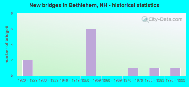
- New bridges - historical statistics
- 21920-1929
- 61950-1959
- 11970-1979
- 11980-1989
- 11990-1999

- Reconstructed bridges - Historical Statistics
- 41980-1989
- 21990-1999
- 12000-2009


- Bridge Condition - Deck
- 77.8%Good
- 22.2%Satisfactory

- Bridge Condition - Superstructure
- 22.2%Very good
- 55.6%Good
- 11.1%Satisfactory
- 11.1%Poor

- Bridge Condition - Substructure
- 11.1%Very good
- 22.2%Good
- 66.7%Satisfactory

- Bridge Condition - Channel
- 25.0%Very good
- 50.0%Good
- 25.0%Satisfactory
Find on map >> Show street view
Structure Number: 24007100137, Location: 6.6 MI FROM LITTLETON TL (Lat: 44.313175, Lng: -71.670056), Route carried "on" structure: Other road , Year Built: 1928, Year Reconstructed: 2011, Status: Open, Structure Length: 3.38m (11.09ft), Average Daily Traffic: 186 (year 2020), Truck Traffic: 4%, Average Future Daily Traffic: 275 (year 2042), Design Load: H 15, Features Intersected: AMMONOOSUC RIVER, Facility Carried by Structure: PROSPECT STREET
Minimum Vertical Clearance: 4.27m (14.01ft), Kilometerpoint: 4.633, Lanes on structure: 1, Owner: City or Municipal Highway Agency, Approaching Roadway Width: 4.8m (15.7ft), Material/Design: Steel, Design/Construction: Truss - Thru, Number Of Spans In Main Unit: 1, Length of Maximum Span: 31.1m (102.0ft), Curb-To-Curb Width: 4.9m (16.1ft), Out-to-Out Width: 5.5m (18.0ft)
Condition: Deck: Good, Superstructure: Very good, Substructure: Satisfactory, Channel: Very good, Operating Rating: 67.9 metric tons, Method Used To Determine Operating Rating: Load and Resistance Factor (LRFR), Inventory Rating: 53.4 metric tons, Method Used To Determine Inventory Rating: Load and Resistance Factor (LRFR), Structural Evaluation: Equal to present minimum criteria, Deck Geometry: High priority of replacement, Waterway Adequacy: Equal to present desirable criteria, Approach Roadway Alignment: Equal to present desirable criteria, Length Of Structure Improvement: 3.38m (11.09ft), Designated Inspection Frequency: Every 24 months, Critical Feature Inspection Frequency: Every 24 months, Inspection Date: August 2021, Critical Feature Inspection Date: August 2021, Bridge Improvement Cost: $2,718,000, Roadway Improvement Cost: $200,000, Total Project Cost: $3,142,000 ( Estimate for 2022), Deck Structure Type: Wood or Timber, Wearing Surface/Protective System: Wearing Surface: Bituminous
Find on map >> Show street view
Structure Number: 24009900152, Location: 2.2 MI FROM WHITEFIELD TL (Lat: 44.293819, Lng: -71.657633), Route carried "on" structure: State highway 142, Year Built: 1927, Year Reconstructed: 1998, Status: Open, Structure Length: 3.78m (12.40ft), Average Daily Traffic: 1,098 (year 2020), Truck Traffic: 10%, Average Future Daily Traffic: 1,625 (year 2042), Design Load: H 15, Features Intersected: AMMONOOSUC RIVER
Minimum Vertical Clearance: 4.24m (13.91ft), Kilometerpoint: 12.210, Lanes on structure: 2, Owner: State Highway Agency, Approaching Roadway Width: 6.7m (22.0ft), Material/Design: Steel, Design/Construction: Truss - Thru, Number Of Spans In Main Unit: 1, Length of Maximum Span: 35.7m (117.1ft), Curb or Sidewalk Widths: Left: 0.1m (0.3ft), Right: 0.1m (0.3ft), Curb-To-Curb Width: 6.4m (21.0ft), Out-to-Out Width: 7.3m (24.0ft)
Condition: Deck: Satisfactory, Superstructure: Poor, Substructure: Satisfactory, Channel: Good, Operating Rating: 40.8 metric tons, Method Used To Determine Operating Rating: Load Factor (LF), Inventory Rating: 24.5 metric tons, Method Used To Determine Inventory Rating: Load Factor (LF), Structural Evaluation: Meets minimum limits, Deck Geometry: High priority of replacement, Waterway Adequacy: Superior to present desirable criteria, Approach Roadway Alignment: High priority of corrective action, Length Of Structure Improvement: 3.78m (12.40ft), Designated Inspection Frequency: Every 8 months, Critical Feature Inspection Frequency: Every 24 months, Inspection Date: November 2021, Critical Feature Inspection Date: June 2021, Bridge Improvement Cost: $2,718,000, Roadway Improvement Cost: $200,000, Total Project Cost: $3,142,000 ( Estimate for 2022), Deck Structure Type: Concrete Cast-file-Place, Wearing Surface/Protective System: Wearing Surface: Bituminous
Find on map >> Show street view
Structure Number: 2401000005, Location: 0.03 MI LITTLETON TL (Lat: 44.293500, Lng: -71.760067), Route carried "on" structure: Interstate 93, Year Built: 1959, Year Reconstructed: 1991, Status: Open, Structure Length: 2.38m (7.81ft), Average Daily Traffic: 3,757 (year 2020), Truck Traffic: 9%, Average Future Daily Traffic: 5,560 (year 2042), Design Load: HS 20+Mod, Features Intersected: US302,NH 10,NH 18,NH116
Minimum Vertical Clearance: 30+ m (98+ ft), Kilometerpoint: 15.432, Lanes on structure: 2, Lanes under structure: 2, Base Highway Network: Yes, Owner: State Highway Agency, Approaching Roadway Width: 11.6m (38.1ft), Skew: 5 degrees, Material/Design: Steel, Design/Construction: Stringer/Multi-beam, Number Of Spans In Main Unit: 1, Length of Maximum Span: 21.3m (69.9ft), Curb or Sidewalk Widths: Left: 0.1m (0.3ft), Right: 0.1m (0.3ft), Curb-To-Curb Width: 12.3m (40.4ft), Out-to-Out Width: 13.4m (44.0ft)
Condition: Deck: Good, Superstructure: Good, Substructure: Satisfactory, Operating Rating: 60.4 metric tons, Method Used To Determine Operating Rating: Load Factor (LF), Inventory Rating: 36.1 metric tons, Method Used To Determine Inventory Rating: Load Factor (LF), Structural Evaluation: Equal to present minimum criteria, Deck Geometry: Better than present minimum criteria, Underclear: Meets minimum limits, Approach Roadway Alignment: Equal to present desirable criteria, Length Of Structure Improvement: 2.38m (7.81ft), Designated Inspection Frequency: Every 24 months, Inspection Date: June 2021, Bridge Improvement Cost: $2,718,000, Roadway Improvement Cost: $200,000, Total Project Cost: $3,142,000 ( Estimate for 2022), Deck Structure Type: Concrete Cast-file-Place, Wearing Surface/Protective System: Wearing Surface: Bituminous, Membrane: Other
Find on map >> Show street view
Structure Number: 24011100064, Location: 2.1 MI SUGARHILL TL (Lat: 44.284458, Lng: -71.744258), Route carried "on" structure: US 302, Year Built: 1959, Year Reconstructed: 1988, Status: Open, Structure Length: 8.78m (28.81ft), Average Daily Traffic: 2,698 (year 2020), Truck Traffic: 7%, Average Future Daily Traffic: 3,993 (year 2042), Design Load: HS 25 or greater, Features Intersected: I-93
Minimum Vertical Clearance: 30+ m (98+ ft), Kilometerpoint: 38.207, Lanes on structure: 2, Lanes under structure: 5, Base Highway Network: Yes, Owner: State Highway Agency, Approaching Roadway Width: 13.4m (44.0ft), Skew: 3 degrees, Material/Design: Steel, Design/Construction: Stringer/Multi-beam, Number Of Spans In Main Unit: 5, Length of Maximum Span: 22.6m (74.1ft), Curb or Sidewalk Widths: Left: 0.2m (0.7ft), Right: 0.2m (0.7ft), Curb-To-Curb Width: 14.0m (45.9ft), Out-to-Out Width: 15.5m (50.9ft)
Condition: Deck: Satisfactory, Superstructure: Satisfactory, Substructure: Satisfactory, Operating Rating: 78.9 metric tons, Method Used To Determine Operating Rating: Load Factor (LF), Inventory Rating: 47.2 metric tons, Method Used To Determine Inventory Rating: Load Factor (LF), Structural Evaluation: Equal to present minimum criteria, Deck Geometry: Superior to present desirable criteria, Underclear: High priority of replacement, Approach Roadway Alignment: Equal to present desirable criteria, Length Of Structure Improvement: 8.78m (28.81ft), Designated Inspection Frequency: Every 24 months, Inspection Date: May 2021, Bridge Improvement Cost: $2,718,000, Roadway Improvement Cost: $200,000, Total Project Cost: $3,142,000 ( Estimate for 2022), Deck Structure Type: Concrete Cast-file-Place, Wearing Surface/Protective System: Wearing Surface: Bituminous, Membrane: Other
Find on map >> Show street view
Structure Number: 24011900065, Location: 1.7 MI SUGARHILL TL (Lat: 44.278819, Lng: -71.743036), Route carried "on" structure: Other road , Year Built: 1959, Year Reconstructed: 1990, Status: Open, Structure Length: 7.44m (24.41ft), Average Daily Traffic: 148 (year 2020), Truck Traffic: 4%, Average Future Daily Traffic: 219 (year 2042), Design Load: HS 20, Features Intersected: I-93, Facility Carried by Structure: WEST FARM ROAD
Minimum Vertical Clearance: 30+ m (98+ ft), Kilometerpoint: 2.058, Lanes on structure: 2, Lanes under structure: 4, Owner: State Highway Agency, Approaching Roadway Width: 6.1m (20.0ft), Skew: 1 degrees, Material/Design: Steel continuous, Design/Construction: Stringer/Multi-beam, Number Of Spans In Main Unit: 5, Length of Maximum Span: 20.1m (65.9ft), Curb or Sidewalk Widths: Left: 0.1m (0.3ft), Right: 0.1m (0.3ft), Curb-To-Curb Width: 8.2m (26.9ft), Out-to-Out Width: 9.3m (30.5ft)
Condition: Deck: Good, Superstructure: Good, Substructure: Good, Operating Rating: 57.2 metric tons, Method Used To Determine Operating Rating: Load Factor (LF), Inventory Rating: 34.5 metric tons, Method Used To Determine Inventory Rating: Load Factor (LF), Structural Evaluation: Better than present minimum criteria, Deck Geometry: Somewhat better than minimum adequacy, Underclear: High priority of replacement, Approach Roadway Alignment: Equal to present desirable criteria, Length Of Structure Improvement: 7.44m (24.41ft), Designated Inspection Frequency: Every 24 months, Inspection Date: May 2021, Bridge Improvement Cost: $2,718,000, Roadway Improvement Cost: $200,000, Total Project Cost: $3,142,000 ( Estimate for 2022), Deck Structure Type: Concrete Cast-file-Place, Wearing Surface/Protective System: Wearing Surface: Bituminous, Membrane: Other
Find on map >> Show street view
Structure Number: 24012500177, Location: 2.9 MI FROM CARROLL TL (Lat: 44.272928, Lng: -71.632369), Route carried "on" structure: US 302, Year Built: 1983, Status: Open, Structure Length: 12.22m (40.09ft), Average Daily Traffic: 3,477 (year 2020), Truck Traffic: 7%, Average Future Daily Traffic: 5,145 (year 2042), Design Load: HS 20+Mod, Features Intersected: AMMONOOSUC RIVER
Minimum Vertical Clearance: 30+ m (98+ ft), Kilometerpoint: 47.662, Lanes on structure: 2, Base Highway Network: Yes, Owner: State Highway Agency, Approaching Roadway Width: 13.4m (44.0ft), Skew: 6 degrees, Material/Design: Steel continuous, Design/Construction: Stringer/Multi-beam, Number Of Spans In Main Unit: 3, Length of Maximum Span: 45.1m (148.0ft), Curb or Sidewalk Widths: Left: 0.2m (0.7ft), Right: 1.5m (4.9ft), Curb-To-Curb Width: 13.2m (43.3ft), Out-to-Out Width: 15.7m (51.5ft)
Condition: Deck: Good, Superstructure: Good, Substructure: Good, Channel: Good, Operating Rating: 59.0 metric tons, Method Used To Determine Operating Rating: Load Factor (LF), Inventory Rating: 35.4 metric tons, Method Used To Determine Inventory Rating: Load Factor (LF), Structural Evaluation: Better than present minimum criteria, Deck Geometry: Equal to present minimum criteria, Waterway Adequacy: Superior to present desirable criteria, Approach Roadway Alignment: Equal to present desirable criteria, Length Of Structure Improvement: 12.22m (40.09ft), Designated Inspection Frequency: Every 24 months, Inspection Date: June 2020, Bridge Improvement Cost: $2,718,000, Roadway Improvement Cost: $200,000, Total Project Cost: $3,142,000 ( Estimate for 2022), Deck Structure Type: Concrete Cast-file-Place, Wearing Surface/Protective System: Wearing Surface: Bituminous, Membrane: Preformed Fabric
Find on map >> Show street view
Structure Number: 2401470006, Location: 0.3 MI SUGARHILL TL (Lat: 44.260308, Lng: -71.752139), Route carried "on" structure: Interstate 93, Year Built: 1959, Year Reconstructed: 1991, Status: Open, Structure Length: 1.98m (6.50ft), Average Daily Traffic: 2,304 (year 2020), Truck Traffic: 9%, Average Future Daily Traffic: 3,409 (year 2042), Design Load: HS 20+Mod, Features Intersected: NH 18,NH116
Minimum Vertical Clearance: 30+ m (98+ ft), Kilometerpoint: 20.040, Lanes on structure: 2, Lanes under structure: 2, Base Highway Network: Yes, Owner: State Highway Agency, Approaching Roadway Width: 11.9m (39.0ft), Skew: 24 degrees, Material/Design: Steel, Design/Construction: Stringer/Multi-beam, Number Of Spans In Main Unit: 1, Length of Maximum Span: 18.0m (59.1ft), Curb or Sidewalk Widths: Left: 2.4m (7.9ft), Right: 0.1m (0.3ft), Curb-To-Curb Width: 16.2m (53.1ft), Out-to-Out Width: 16.7m (54.8ft)
Condition: Deck: Good, Superstructure: Good, Substructure: Satisfactory, Operating Rating: 89.8 metric tons, Method Used To Determine Operating Rating: Load Factor (LF), Inventory Rating: 62.6 metric tons, Method Used To Determine Inventory Rating: Load Factor (LF), Structural Evaluation: Equal to present minimum criteria, Deck Geometry: Superior to present desirable criteria, Underclear: Meets minimum limits, Approach Roadway Alignment: Equal to present desirable criteria, Length Of Structure Improvement: 1.98m (6.50ft), Designated Inspection Frequency: Every 24 months, Inspection Date: May 2021, Bridge Improvement Cost: $2,718,000, Roadway Improvement Cost: $200,000, Total Project Cost: $3,142,000 ( Estimate for 2022), Deck Structure Type: Concrete Cast-file-Place, Wearing Surface/Protective System: Wearing Surface: Bituminous, Membrane: Preformed Fabric, Deck Protection: Epoxy Coated Reinforcing
Find on map >> Show street view
Structure Number: 2401480006, Location: 0.7 M N SUGARHILL TL (Lat: 44.260361, Lng: -71.751739), Route carried "on" structure: Interstate 93, Year Built: 1972, Year Reconstructed: 1991, Status: Open, Structure Length: 1.95m (6.40ft), Average Daily Traffic: 2,531 (year 2020), Truck Traffic: 9%, Average Future Daily Traffic: 3,745 (year 2042), Design Load: HS 20+Mod, Features Intersected: NH 18,NH116
Minimum Vertical Clearance: 30+ m (98+ ft), Kilometerpoint: 191.798, Lanes on structure: 3, Lanes under structure: 2, Base Highway Network: Yes, Owner: State Highway Agency, Approaching Roadway Width: 17.1m (56.1ft), Skew: 4 degrees, Material/Design: Steel, Design/Construction: Stringer/Multi-beam, Number Of Spans In Main Unit: 1, Length of Maximum Span: 17.5m (57.4ft), Curb or Sidewalk Widths: Left: 3.7m (12.1ft), Right: 0.1m (0.3ft), Curb-To-Curb Width: 24.7m (81.0ft), Out-to-Out Width: 24.9m (81.7ft)
Condition: Deck: Good, Superstructure: Very good, Substructure: Satisfactory, Operating Rating: 51.7 metric tons, Method Used To Determine Operating Rating: Load Factor (LF), Inventory Rating: 30.8 metric tons, Method Used To Determine Inventory Rating: Load Factor (LF), Structural Evaluation: Equal to present minimum criteria, Deck Geometry: Superior to present desirable criteria, Underclear: Meets minimum limits, Approach Roadway Alignment: Equal to present desirable criteria, Length Of Structure Improvement: 1.95m (6.40ft), Designated Inspection Frequency: Every 24 months, Inspection Date: May 2021, Bridge Improvement Cost: $2,718,000, Roadway Improvement Cost: $200,000, Total Project Cost: $3,142,000 ( Estimate for 2022), Deck Structure Type: Concrete Cast-file-Place, Wearing Surface/Protective System: Wearing Surface: Bituminous, Membrane: Preformed Fabric
Find on map >> Show street view
Structure Number: 24016700174, Location: 2.0 MI FROM FRANCONIA TL (Lat: 44.243758, Lng: -71.638250), Route carried "on" structure: US 3, Year Built: 1990, Status: Open, Structure Length: 2.29m (7.51ft), Average Daily Traffic: 5,113 (year 2020), Truck Traffic: 7%, Average Future Daily Traffic: 7,567 (year 2042), Design Load: HS 25 or greater, Features Intersected: GALE RIVER
Minimum Vertical Clearance: 30+ m (98+ ft), Kilometerpoint: 230.802, Lanes on structure: 2, Owner: State Highway Agency, Approaching Roadway Width: 13.4m (44.0ft), Material/Design: Steel, Design/Construction: Stringer/Multi-beam, Number Of Spans In Main Unit: 1, Length of Maximum Span: 21.3m (69.9ft), Curb or Sidewalk Widths: Left: 0.2m (0.7ft), Right: 0.2m (0.7ft), Curb-To-Curb Width: 13.1m (43.0ft), Out-to-Out Width: 14.3m (46.9ft)
Condition: Deck: Good, Superstructure: Good, Substructure: Very good, Channel: Satisfactory, Operating Rating: 78.9 metric tons, Method Used To Determine Operating Rating: Load Factor (LF), Inventory Rating: 47.2 metric tons, Method Used To Determine Inventory Rating: Load Factor (LF), Structural Evaluation: Better than present minimum criteria, Deck Geometry: Somewhat better than minimum adequacy, Waterway Adequacy: Superior to present desirable criteria, Approach Roadway Alignment: Equal to present desirable criteria, Length Of Structure Improvement: 2.29m (7.51ft), Designated Inspection Frequency: Every 24 months, Inspection Date: March 2020, Bridge Improvement Cost: $2,718,000, Roadway Improvement Cost: $200,000, Total Project Cost: $3,142,000 ( Estimate for 2022), Deck Structure Type: Concrete Cast-file-Place, Wearing Surface/Protective System: Wearing Surface: Bituminous, Membrane: Preformed Fabric, Deck Protection: Epoxy Coated Reinforcing
Find on map >> Show street view
Structure Number: 24011100064, Location: 2.1 MI SUGARHILL TL (Lat: 44.284458, Lng: -71.744258), Route carried "under" structure: Interstate 93, Year Built: 1959, Structure Length: 0. m, Average Daily Traffic: 6,800 (year 2002), Truck Traffic: 9%, Features Intersected: I-93, Facility Carried by Structure: US302,NH 18,NH116
Minimum Vertical Clearance: 5.29m (17.36ft), Kilometerpoint: 0.000, Lanes on structure: 2, Lanes under structure: 5, Material/Design: Steel, Design/Construction: Stringer/Multi-beam, Length of Maximum Span: 22.6m (74.1ft)
Find on map >> Show street view
Structure Number: 24011900065, Location: 1.7 MI SUGARHILL TL (Lat: 44.278819, Lng: -71.743036), Route carried "under" structure: Interstate 93, Year Built: 1959, Structure Length: 0. m, Average Daily Traffic: 6,200 (year 2008), Truck Traffic: 9%, Features Intersected: I-93, Facility Carried by Structure: WEST FARM ROAD
Minimum Vertical Clearance: 5.28m (17.32ft), Kilometerpoint: 0.000, Lanes on structure: 2, Lanes under structure: 4, Material/Design: Steel continuous, Design/Construction: Stringer/Multi-beam, Length of Maximum Span: 20.1m (65.9ft)