Bridge Statistics for Bethpage, New York (NY)
Condition, Traffic, Stress, Structural Evaluation, Project Costs
- National Bridge Inventory (NBI) Statistics
- 11Number of bridges
- 43ft / 13.3mTotal length
- $28,913,000Total costs
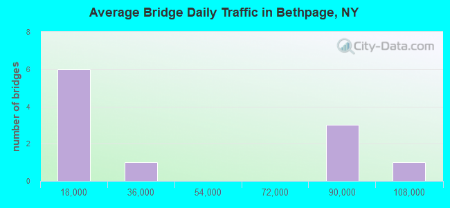
- 468,314Total average daily traffic
- 7,195Total average daily truck traffic
- National Bridge Inventory (NBI) Registered Bridges for Bethpage
- No street view available for this location
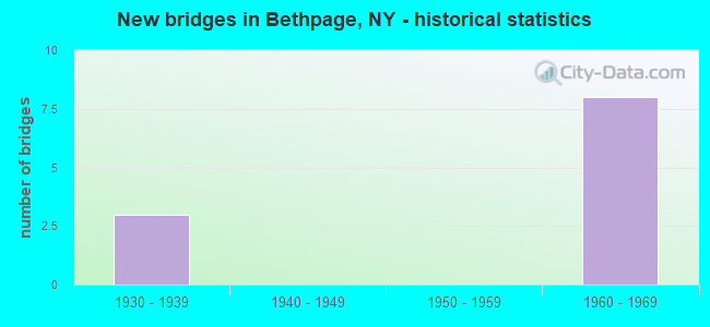
- New bridges - historical statistics
- 31930-1939
- 81960-1969
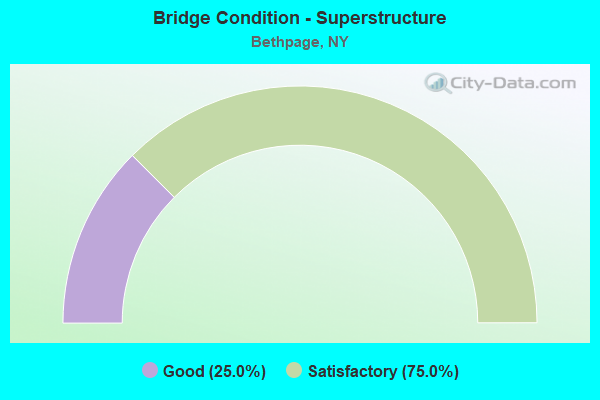
- Bridge Condition - Superstructure
- 25.0%Good
- 75.0%Satisfactory
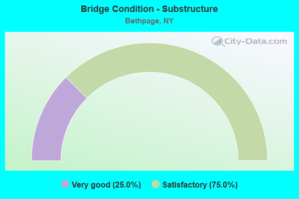
- Bridge Condition - Substructure
- 25.0%Very good
- 75.0%Satisfactory
Find on map >> Show street view
Structure Number: 103786, Location: .7 MI N JCT SH 24 & SH135 (Lat: 40.736469, Lng: -73.474183), Route carried "on" structure: Other road , Year Built: 1962, Status: Open, Structure Length: 4.57m (14.99ft), Average Daily Traffic: 17,552 (year 2020), Truck Traffic: 5%, Average Future Daily Traffic: 21,322 (year 2040), Design Load: H 20, Features Intersected: 135 135 03011063 Northbo, Facility Carried by Structure: CENTRAL AVENUE
Minimum Vertical Clearance: 30+ m (98+ ft), Kilometerpoint: 1.883, Lanes on structure: 4, Lanes under structure: 6, Owner: State Highway Agency, Approaching Roadway Width: 16.5m (54.1ft), Skew: 24 degrees, Material/Design: Steel, Design/Construction: Stringer/Multi-beam, Number Of Spans In Main Unit: 2, Length of Maximum Span: 22.2m (72.8ft), Curb or Sidewalk Widths: Left: 2.1m (6.9ft), Right: 2.1m (6.9ft), Curb-To-Curb Width: 16.5m (54.1ft), Out-to-Out Width: 20.7m (67.9ft)
Condition: Deck: Satisfactory, Superstructure: Satisfactory, Substructure: Satisfactory, Operating Rating: 86.2 metric tons, Method Used To Determine Operating Rating: Load and Resistance Factor Rating (LRFR) rating reported by rating factor(RF) method using HL-93 loadings, Inventory Rating: 66.4 metric tons, Method Used To Determine Inventory Rating: Load and Resistance Factor Rating (LRFR) rating reported by rating factor(RF) method using HL-93 loadings, Structural Evaluation: Equal to present minimum criteria, Deck Geometry: Meets minimum limits, Underclear: High priority of corrective action, Approach Roadway Alignment: Better than present minimum criteria, Length Of Structure Improvement: 4.57m (14.99ft), Designated Inspection Frequency: Every 24 months, Inspection Date: July 2021, Bridge Improvement Cost: $5,803,000, Roadway Improvement Cost: $3,398,000, Total Project Cost: $9,202,000 ( Estimate for 2021), Deck Structure Type: Concrete Cast-file-Place, Wearing Surface/Protective System: Wearing Surface: Integral Concrete
Find on map >> Show street view
Structure Number: 103788, Location: 1.1 MI N JCT SH24 & SH135 (Lat: 40.743208, Lng: -73.473889), Route carried "on" structure: Other road , Year Built: 1962, Status: Open, Structure Length: 3.66m (12.01ft), Average Daily Traffic: 11,160 (year 2020), Truck Traffic: 2%, Average Future Daily Traffic: 13,808 (year 2040), Design Load: H 20, Features Intersected: 135 135 03011067 NB, RTE, Facility Carried by Structure: POWELL AVENUE
Minimum Vertical Clearance: 30+ m (98+ ft), Kilometerpoint: 0.483, Lanes on structure: 2, Lanes under structure: 7, Owner: State Highway Agency, Approaching Roadway Width: 12.2m (40.0ft), Material/Design: Steel, Design/Construction: Stringer/Multi-beam, Number Of Spans In Main Unit: 2, Length of Maximum Span: 18.8m (61.7ft), Curb or Sidewalk Widths: Left: 1.6m (5.2ft), Right: 1.6m (5.2ft), Curb-To-Curb Width: 12.2m (40.0ft), Out-to-Out Width: 16.4m (53.8ft)
Condition: Deck: Satisfactory, Superstructure: Satisfactory, Substructure: Satisfactory, Operating Rating: 76.1 metric tons, Method Used To Determine Operating Rating: Load and Resistance Factor Rating (LRFR) rating reported by rating factor(RF) method using HL-93 loadings, Inventory Rating: 58.6 metric tons, Method Used To Determine Inventory Rating: Load and Resistance Factor Rating (LRFR) rating reported by rating factor(RF) method using HL-93 loadings, Structural Evaluation: Equal to present minimum criteria, Deck Geometry: Somewhat better than minimum adequacy, Underclear: High priority of corrective action, Approach Roadway Alignment: Equal to present minimum criteria, Length Of Structure Improvement: 3.65m (11.98ft), Designated Inspection Frequency: Every 24 months, Inspection Date: May 2021, Bridge Improvement Cost: $3,365,000, Roadway Improvement Cost: $1,970,000, Total Project Cost: $5,335,000 ( Estimate for 2021), Deck Structure Type: Concrete Cast-file-Place, Wearing Surface/Protective System: Wearing Surface: Bituminous, Membrane: Preformed Fabric
Find on map >> Show street view
Structure Number: 1037899, Location: 1.9 MI S JCT RTE 135+SSP (Lat: 40.755417, Lng: -73.474825), Route carried "on" structure: State highway 135, Year Built: 1962, Status: Open, Structure Length: 2.47m (8.10ft), Average Daily Traffic: 86,041 (year 2020), Truck Traffic: 6%, Average Future Daily Traffic: 102,345 (year 2040), Design Load: H 20, Features Intersected: BROADWAY
Minimum Vertical Clearance: 30+ m (98+ ft), Kilometerpoint: 10.491, Lanes on structure: 6, Lanes under structure: 4, Base Highway Network: Yes, Owner: State Highway Agency, Approaching Roadway Width: 29.9m (98.1ft), Skew: 20 degrees, Material/Design: Steel, Design/Construction: Stringer/Multi-beam, Number Of Spans In Main Unit: 1, Length of Maximum Span: 23.1m (75.8ft), Curb-To-Curb Width: 29.7m (97.4ft), Out-to-Out Width: 32.1m (105.3ft)
Condition: Deck: Satisfactory, Superstructure: Satisfactory, Substructure: Satisfactory, Operating Rating: 83.5 metric tons, Method Used To Determine Operating Rating: Load Factor (LF), Inventory Rating: 49.9 metric tons, Method Used To Determine Inventory Rating: Load Factor (LF), Structural Evaluation: Equal to present minimum criteria, Deck Geometry: Superior to present desirable criteria, Underclear: Somewhat better than minimum adequacy, Approach Roadway Alignment: Equal to present desirable criteria, Length Of Structure Improvement: 2.46m (8.07ft), Designated Inspection Frequency: Every 24 months, Inspection Date: August 2021, Bridge Improvement Cost: $5,548,000, Roadway Improvement Cost: $3,249,000, Total Project Cost: $8,796,000 ( Estimate for 2021), Deck Structure Type: Concrete Cast-file-Place, Wearing Surface/Protective System: Wearing Surface: Bituminous, Membrane: Preformed Fabric
Find on map >> Show street view
Structure Number: 10591, Location: .7 MI NE JCT RTS 24+135 (Lat: 40.735544, Lng: -73.469981), Route carried "on" structure: Other road , Year Built: 1936, Status: Open, Structure Length: 2.59m (8.50ft), Average Daily Traffic: 13,333 (year 2020), Truck Traffic: 7%, Average Future Daily Traffic: 16,196 (year 2040), Design Load: H 20, Features Intersected: RTE 907E, BIKE PATH, Facility Carried by Structure: CENTRAL AVENUE
Minimum Vertical Clearance: 30+ m (98+ ft), Kilometerpoint: 0.097, Lanes on structure: 2, Lanes under structure: 3, Owner: State Highway Agency, Approaching Roadway Width: 15.2m (49.9ft), Skew: 2 degrees, Material/Design: Concrete, Design/Construction: Arch - Deck, Number Of Spans In Main Unit: 1, Length of Maximum Span: 23.1m (75.8ft), Curb or Sidewalk Widths: Left: 1.5m (4.9ft), Right: 1.7m (5.6ft), Curb-To-Curb Width: 15.1m (49.5ft), Out-to-Out Width: 18.3m (60.0ft)
Condition: Superstructure: Good, Substructure: Very good, Operating Rating: 62.6 metric tons, Method Used To Determine Operating Rating: Field evaluation and documented engineering judgment, Inventory Rating: 23.9 metric tons, Method Used To Determine Inventory Rating: Field evaluation and documented engineering judgment, Structural Evaluation: Somewhat better than minimum adequacy, Deck Geometry: Superior to present desirable criteria, Underclear: High priority of corrective action, Approach Roadway Alignment: Better than present minimum criteria, Length Of Structure Improvement: 2.59m (8.50ft), Designated Inspection Frequency: Every 24 months, Inspection Date: January 2020, Bridge Improvement Cost: $3,519,000, Roadway Improvement Cost: $2,061,000, Total Project Cost: $5,580,000 ( Estimate for 2021), Wearing Surface/Protective System: Wearing Surface: Bituminous
Find on map >> Show street view
Structure Number: 103786, Location: .7 MI N JCT SH 24 & SH135 (Lat: 40.736469, Lng: -73.474183), Route carried "under" structure: State highway 135, Year Built: 1962, Structure Length: 0. m, Average Daily Traffic: 89,244 (year 2002), Features Intersected: 135 135 03011063 Northbo, Facility Carried by Structure: CENTRAL AVENUE
Minimum Vertical Clearance: 5.36m (17.59ft), Kilometerpoint: 8.673, Lanes on structure: 4, Lanes under structure: 3, Material/Design: Steel, Design/Construction: Stringer/Multi-beam, Length of Maximum Span: 22.2m (72.8ft)
Find on map >> Show street view
Structure Number: 103788, Location: 1.1 MI N JCT SH24 & SH135 (Lat: 40.743208, Lng: -73.473889), Route carried "under" structure: State highway 135, Year Built: 1962, Structure Length: 0. m, Average Daily Traffic: 104,968 (year 2002), Features Intersected: 135 135 03011067 NB, RTE, Facility Carried by Structure: POWELL AVENUE
Minimum Vertical Clearance: 4.62m (15.16ft), Kilometerpoint: 9.429, Lanes on structure: 2, Lanes under structure: 3, Material/Design: Steel, Design/Construction: Stringer/Multi-beam, Length of Maximum Span: 18.8m (61.7ft)
Find on map >> Show street view
Structure Number: 1037899, Location: 1.9 MI S JCT RTE 135+SSP (Lat: 40.755417, Lng: -73.474825), Route carried "under" structure: Other road , Year Built: 1962, Structure Length: 0. m, Average Daily Traffic: 11,800 (year 2021), Features Intersected: BROADWAY, Facility Carried by Structure: RTE 135
Minimum Vertical Clearance: 5.51m (18.08ft), Kilometerpoint: 0.000, Lanes on structure: 6, Lanes under structure: 4, Material/Design: Steel, Design/Construction: Stringer/Multi-beam, Length of Maximum Span: 23.1m (75.8ft)
Find on map >> Show street view
Structure Number: 10591, Location: .7 MI NE JCT RTS 24+135 (Lat: 40.735544, Lng: -73.469981), Route carried "under" structure: State highway 907E, Year Built: 1936, Structure Length: 0. m, Average Daily Traffic: 11,900 (year 1975), Features Intersected: RTE 907E, BIKE PATH, Facility Carried by Structure: CENTRAL AVENUE
Minimum Vertical Clearance: 4.27m (14.01ft), Kilometerpoint: 3.829, Lanes on structure: 2, Lanes under structure: 3, Material/Design: Concrete, Design/Construction: Arch - Deck, Length of Maximum Span: 23.1m (75.8ft)
Find on map >> Show street view
Structure Number: 703787, Location: .7 MI N JCT RTS 24+135 (Lat: 40.736889, Lng: -73.473969), Route carried "under" structure: State highway 135, Year Built: 1963, Structure Length: 0. m, Average Daily Traffic: 89,244 (year 2002), Features Intersected: RTE 135, Facility Carried by Structure: LONG ISLAND
Minimum Vertical Clearance: 4.31m (14.14ft), Kilometerpoint: 8.737, Lanes under structure: 6, Material/Design: Steel, Design/Construction: Girder and Floorbeam System, Length of Maximum Span: 21.0m (68.9ft)
Find on map >> Show street view
Structure Number: 705672, Location: .7 MI NE JCT RTS 24+135 (Lat: 40.734314, Lng: -73.470056), Route carried "under" structure: Other road 907E, Year Built: 1936, Structure Length: 0. m, Average Daily Traffic: 13,072 (year 2002), Features Intersected: RTE 907E, Facility Carried by Structure: LONG ISLAND
Minimum Vertical Clearance: 3.98m (13.06ft), Kilometerpoint: 3.701, Lanes under structure: 2, Material/Design: Steel, Design/Construction: Girder and Floorbeam System, Length of Maximum Span: 20.7m (67.9ft)
Find on map >> Show street view
Structure Number: 770922, Location: 0.6 MI SE OF BETHPAGE (Lat: 40.735769, Lng: -73.472347), Route carried "under" structure: County highway , Year Built: 1963, Structure Length: 0. m, Average Daily Traffic: 20,000 (year 1977), Features Intersected: CENTRAL AVE, Facility Carried by Structure: LIRR MAIN LINE
Minimum Vertical Clearance: 4.31m (14.14ft), Kilometerpoint: 0.000, Lanes under structure: 4, Material/Design: Steel, Design/Construction: Girder and Floorbeam System, Length of Maximum Span: 31.6m (103.7ft)