Bridge Statistics for Beulah, North Dakota (ND)
Condition, Traffic, Stress, Structural Evaluation, Project Costs
- National Bridge Inventory (NBI) Statistics
- 10Number of bridges
- 98ft / 30.3mTotal length
- $592,000Total costs
- 11,899Total average daily traffic
- 845Total average daily truck traffic
- 13,628Total future (year 2037) average daily traffic
- National Bridge Inventory (NBI) Registered Bridges for Beulah
- No street view available for this location
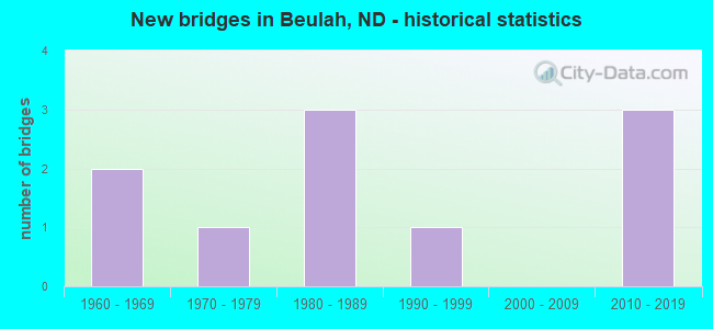
- New bridges - historical statistics
- 21960-1969
- 11970-1979
- 31980-1989
- 11990-1999
- 32010-2019


- Bridge Condition - Deck
- 42.9%Very good
- 42.9%Good
- 14.3%Satisfactory

- Bridge Condition - Superstructure
- 28.6%Very good
- 57.1%Good
- 14.3%Satisfactory

- Bridge Condition - Substructure
- 57.1%Very good
- 42.9%Good

- Bridge Condition - Channel
- 22.2%Excellent
- 55.6%Very good
- 22.2%Good

- Bridge Condition - Culverts
- 66.7%Very good
- 33.3%Satisfactory
Find on map >> Show street view
Structure Number: 29118214, Location: 2 WEST .5 SOUTH OF BEULAH (Lat: 47.261211, Lng: -101.827997), Route carried "on" structure: County highway , Year Built: 1979, Status: Open, Structure Length: 1.25m (4.10ft), Average Daily Traffic: 10 (year 2018), Average Future Daily Traffic: 10 (year 2038), Design Load: H 20, Features Intersected: SPRING CREEK, Facility Carried by Structure: COUNTY HIGHWAY
Minimum Vertical Clearance: 30+ m (98+ ft), Kilometerpoint: 0.000, Lanes on structure: 2, Owner: County Highway Agency, Approaching Roadway Width: 6.1m (20.0ft), Material/Design: Prestressed concrete, Design/Construction: Box Beam or Girders - Multiple, Number Of Spans In Main Unit: 1, Length of Maximum Span: 11.6m (38.1ft), Curb-To-Curb Width: 5.5m (18.0ft), Out-to-Out Width: 5.5m (18.0ft)
Condition: Deck: Satisfactory, Superstructure: Satisfactory, Substructure: Very good, Channel: Very good, Operating Rating: 68.6 metric tons, Method Used To Determine Operating Rating: Load Factor (LF), Inventory Rating: 39.5 metric tons, Method Used To Determine Inventory Rating: Load Factor (LF), Structural Evaluation: Equal to present minimum criteria, Deck Geometry: Meets minimum limits, Waterway Adequacy: High priority of corrective action, Approach Roadway Alignment: Somewhat better than minimum adequacy, Length Of Structure Improvement: 1.25m (4.10ft), Designated Inspection Frequency: Every 24 months, Inspection Date: July 2020, Bridge Improvement Cost: $74,000, Roadway Improvement Cost: $7,000, Total Project Cost: $111,000
Find on map >> Show street view
Structure Number: 2912021, Location: .75 SW OF BEULAH (Lat: 47.255864, Lng: -101.803769), Route carried "on" structure: County highway 2920, Year Built: 1984, Status: Open, Structure Length: 3.23m (10.60ft), Average Daily Traffic: 50 (year 2018), Truck Traffic: 10%, Average Future Daily Traffic: 85 (year 2038), Design Load: H 20, Features Intersected: SPRING CREEK, Facility Carried by Structure: COUNTY HIGHWAY
Minimum Vertical Clearance: 30+ m (98+ ft), Kilometerpoint: 21.561, Lanes on structure: 2, Owner: County Highway Agency, Approaching Roadway Width: 7.3m (24.0ft), Material/Design: Prestressed concrete continuous, Design/Construction: Box Beam or Girders - Single/Spread, Number Of Spans In Main Unit: 3, Length of Maximum Span: 10.1m (33.1ft), Curb-To-Curb Width: 8.5m (27.9ft), Out-to-Out Width: 9.4m (30.8ft)
Condition: Deck: Very good, Superstructure: Very good, Substructure: Very good, Channel: Excellent, Operating Rating: 40.1 metric tons, Method Used To Determine Operating Rating: Load Factor (LF), Inventory Rating: 19.2 metric tons, Method Used To Determine Inventory Rating: Load Factor (LF), Structural Evaluation: Somewhat better than minimum adequacy, Deck Geometry: Better than present minimum criteria, Waterway Adequacy: Superior to present desirable criteria, Approach Roadway Alignment: Equal to present desirable criteria, Designated Inspection Frequency: Every 24 months, Inspection Date: July 2020, Deck Structure Type: Concrete Cast-file-Place, Wearing Surface/Protective System: Wearing Surface: Monolithic Concrete
Find on map >> Show street view
Structure Number: 2912025, Location: 1 WEST 4 SOUTH OF BEULAH (Lat: 47.197867, Lng: -101.805631), Route carried "on" structure: County highway , Year Built: 1994, Status: Open, Structure Length: 0.67m (2.20ft), Average Daily Traffic: 50 (year 2017), Average Future Daily Traffic: 50 (year 2037), Design Load: HS 25 or greater, Features Intersected: BRUSH CREEK, Facility Carried by Structure: COUNTY HIGHWAY
Minimum Vertical Clearance: 30+ m (98+ ft), Kilometerpoint: 0.000, Lanes on structure: 2, Owner: County Highway Agency, Approaching Roadway Width: 8.5m (27.9ft), Material/Design: Concrete, Design/Construction: Culvert, Number Of Spans In Main Unit: 2, Length of Maximum Span: 3.0m (9.8ft)
Condition: Channel: Excellent, Culverts: Very good, Operating Rating: 68.0 metric tons, Method Used To Determine Operating Rating: Field evaluation and documented engineering judgment, Inventory Rating: 40.8 metric tons, Method Used To Determine Inventory Rating: Field evaluation and documented engineering judgment, Structural Evaluation: Equal to present desirable criteria, Waterway Adequacy: Superior to present desirable criteria, Approach Roadway Alignment: Equal to present desirable criteria, Designated Inspection Frequency: Every 24 months, Inspection Date: July 2020
Find on map >> Show street view
Structure Number: 2912221, Location: 1 MILE EAST OF BEULAH (Lat: 47.262397, Lng: -101.744119), Route carried "on" structure: County highway 2920, Year Built: 1982, Status: Open, Structure Length: 5.61m (18.41ft), Average Daily Traffic: 100 (year 2018), Truck Traffic: 12%, Average Future Daily Traffic: 100 (year 2038), Design Load: H 20, Features Intersected: KNIFE RIVER, Facility Carried by Structure: COUNTY HIGHWAY
Minimum Vertical Clearance: 30+ m (98+ ft), Kilometerpoint: 28.158, Lanes on structure: 2, Owner: County Highway Agency, Approaching Roadway Width: 9.1m (29.9ft), Skew: 2 degrees, Material/Design: Prestressed concrete continuous, Design/Construction: Box Beam or Girders - Single/Spread, Number Of Spans In Main Unit: 3, Length of Maximum Span: 21.0m (68.9ft), Curb-To-Curb Width: 8.5m (27.9ft), Out-to-Out Width: 9.3m (30.5ft)
Condition: Deck: Very good, Superstructure: Good, Substructure: Very good, Channel: Very good, Operating Rating: 44.4 metric tons, Method Used To Determine Operating Rating: Load Factor (LF), Inventory Rating: 18.0 metric tons, Method Used To Determine Inventory Rating: Load Factor (LF), Structural Evaluation: Somewhat better than minimum adequacy, Deck Geometry: Better than present minimum criteria, Waterway Adequacy: Equal to present desirable criteria, Approach Roadway Alignment: Equal to present desirable criteria, Designated Inspection Frequency: Every 24 months, Inspection Date: July 2020, Deck Structure Type: Concrete Cast-file-Place, Wearing Surface/Protective System: Wearing Surface: Monolithic Concrete
Find on map >> Show street view
Structure Number: 2912416, Location: 5 WEST 2 NORTH OF HAZEN (Lat: 47.328186, Lng: -101.703486), Route carried "on" structure: County highway , Year Built: 2014, Status: Open, Structure Length: 0.64m (2.10ft), Average Daily Traffic: 24 (year 2017), Average Future Daily Traffic: 24 (year 2037), Design Load: HS 25 or greater, Features Intersected: CREEK, Facility Carried by Structure: COUNTY HIGHWAY
Minimum Vertical Clearance: 30+ m (98+ ft), Kilometerpoint: 0.000, Lanes on structure: 2, Owner: County Highway Agency, Approaching Roadway Width: 7.9m (25.9ft), Material/Design: Concrete, Design/Construction: Culvert, Number Of Spans In Main Unit: 2, Length of Maximum Span: 3.0m (9.8ft)
Condition: Channel: Very good, Culverts: Very good, Operating Rating: 60.9 metric tons, Method Used To Determine Operating Rating: Load and Resistance Factor Rating (LRFR) rating reported by rating factor(RF) method using HL-93 loadings, Inventory Rating: 47.0 metric tons, Method Used To Determine Inventory Rating: Load and Resistance Factor Rating (LRFR) rating reported by rating factor(RF) method using HL-93 loadings, Structural Evaluation: Equal to present desirable criteria, Waterway Adequacy: Equal to present desirable criteria, Approach Roadway Alignment: Equal to present desirable criteria, Designated Inspection Frequency: Every 24 months, Inspection Date: July 2020
Find on map >> Show street view
Structure Number: 2912521, Location: 3 EAST 1 SOUTH OF BEULAH (Lat: 47.255808, Lng: -101.693797), Route carried "on" structure: County highway 2920, Year Built: 1986, Status: Open, Structure Length: 2.56m (8.40ft), Average Daily Traffic: 200 (year 2018), Truck Traffic: 13%, Average Future Daily Traffic: 200 (year 2038), Design Load: H 20, Features Intersected: OTTER CREEK, Facility Carried by Structure: COUNTY HIGHWAY
Minimum Vertical Clearance: 30+ m (98+ ft), Kilometerpoint: 32.743, Lanes on structure: 2, Owner: County Highway Agency, Approaching Roadway Width: 8.5m (27.9ft), Material/Design: Prestressed concrete, Design/Construction: Box Beam or Girders - Single/Spread, Number Of Spans In Main Unit: 1, Length of Maximum Span: 24.4m (80.1ft), Curb-To-Curb Width: 8.5m (27.9ft), Out-to-Out Width: 9.3m (30.5ft)
Condition: Deck: Very good, Superstructure: Very good, Substructure: Very good, Channel: Good, Operating Rating: 89.8 metric tons, Method Used To Determine Operating Rating: Load Factor (LF), Inventory Rating: 33.3 metric tons, Method Used To Determine Inventory Rating: Load Factor (LF), Structural Evaluation: Equal to present desirable criteria, Deck Geometry: Equal to present minimum criteria, Waterway Adequacy: Equal to present desirable criteria, Approach Roadway Alignment: Equal to present desirable criteria, Designated Inspection Frequency: Every 24 months, Inspection Date: July 2020, Deck Structure Type: Concrete Cast-file-Place, Wearing Surface/Protective System: Wearing Surface: Monolithic Concrete
Find on map >> Show street view
Structure Number: 49096039, Location: 8 SOUTH OF BEULAH (Lat: 47.178472, Lng: -101.785233), Route carried "on" structure: State highway 49, Year Built: 2016, Status: Open, Structure Length: 3.23m (10.60ft), Average Daily Traffic: 2,745 (year 2019), Truck Traffic: 7%, Average Future Daily Traffic: 4,095 (year 2039), Design Load: HL 93, Features Intersected: BRUSH CREEK
Minimum Vertical Clearance: 30+ m (98+ ft), Kilometerpoint: 154.527, Lanes on structure: 2, Base Highway Network: Yes, Owner: State Highway Agency, Approaching Roadway Width: 10.4m (34.1ft), Material/Design: Prestressed concrete, Design/Construction: Stringer/Multi-beam, Number Of Spans In Main Unit: 1, Length of Maximum Span: 32.3m (106.0ft), Curb or Sidewalk Widths: Left: 0.4m (1.3ft), Right: 0.4m (1.3ft), Curb-To-Curb Width: 12.2m (40.0ft), Out-to-Out Width: 13.0m (42.7ft)
Condition: Deck: Good, Superstructure: Good, Substructure: Good, Channel: Very good, Operating Rating: 60.6 metric tons, Method Used To Determine Operating Rating: Load and Resistance Factor Rating (LRFR) rating reported by rating factor(RF) method using HL-93 loadings, Inventory Rating: 39.5 metric tons, Method Used To Determine Inventory Rating: Load and Resistance Factor Rating (LRFR) rating reported by rating factor(RF) method using HL-93 loadings, Structural Evaluation: Better than present minimum criteria, Deck Geometry: Equal to present minimum criteria, Waterway Adequacy: Equal to present desirable criteria, Approach Roadway Alignment: Equal to present desirable criteria, Designated Inspection Frequency: Every 24 months, Inspection Date: September 2021, Deck Structure Type: Concrete Cast-file-Place, Wearing Surface/Protective System: Wearing Surface: Monolithic Concrete, Deck Protection: Epoxy Coated Reinforcing
Find on map >> Show street view
Structure Number: 49098857, Location: 5 SOUTH OF BEULAH (Lat: 47.219231, Lng: -101.785739), Route carried "on" structure: State highway 49, Year Built: 1963, Status: Open, Structure Length: 3.08m (10.10ft), Average Daily Traffic: 1,590 (year 2019), Truck Traffic: 7%, Average Future Daily Traffic: 1,474 (year 2039), Design Load: HS 20, Features Intersected: KNIFE RIVER COAL ROAD
Minimum Vertical Clearance: 30+ m (98+ ft), Kilometerpoint: 159.061, Lanes on structure: 2, Lanes under structure: 2, Base Highway Network: Yes, Owner: State Highway Agency, Approaching Roadway Width: 10.4m (34.1ft), Material/Design: Concrete continuous, Design/Construction: Slab, Number Of Spans In Main Unit: 3, Length of Maximum Span: 11.3m (37.1ft), Curb or Sidewalk Widths: Left: 0.5m (1.6ft), Right: 0.5m (1.6ft), Curb-To-Curb Width: 9.2m (30.2ft), Out-to-Out Width: 11.0m (36.1ft)
Condition: Deck: Good, Superstructure: Good, Substructure: Good, Operating Rating: 50.5 metric tons, Method Used To Determine Operating Rating: Load Factor (LF), Inventory Rating: 30.2 metric tons, Method Used To Determine Inventory Rating: Load Factor (LF), Structural Evaluation: Better than present minimum criteria, Deck Geometry: Somewhat better than minimum adequacy, Underclear: High priority of corrective action, Approach Roadway Alignment: Equal to present desirable criteria, Length Of Structure Improvement: 3.66m (12.01ft), Designated Inspection Frequency: Every 24 months, Inspection Date: September 2021, Bridge Improvement Cost: $10,000, Roadway Improvement Cost: $10,000, Total Project Cost: $25,000, Deck Structure Type: Concrete Cast-file-Place, Wearing Surface/Protective System: Wearing Surface: Bituminous
Find on map >> Show street view
Structure Number: 49101247, Location: 1 SOUTH OF BEULAH (Lat: 47.253333, Lng: -101.786667), Route carried "on" structure: State highway 49, Year Built: 2016, Status: Open, Structure Length: 8.78m (28.81ft), Average Daily Traffic: 3,400 (year 2019), Truck Traffic: 7%, Average Future Daily Traffic: 3,300 (year 2039), Design Load: HL 93, Features Intersected: KNIFE RIVER
Minimum Vertical Clearance: 30+ m (98+ ft), Kilometerpoint: 162.906, Lanes on structure: 2, Base Highway Network: Yes, Owner: State Highway Agency, Approaching Roadway Width: 9.8m (32.2ft), Material/Design: Prestressed concrete, Design/Construction: Stringer/Multi-beam, Number Of Spans In Main Unit: 3, Length of Maximum Span: 29.4m (96.5ft), Curb or Sidewalk Widths: Left: 0.4m (1.3ft), Right: 3.7m (12.1ft), Curb-To-Curb Width: 12.2m (40.0ft), Out-to-Out Width: 16.3m (53.5ft)
Condition: Deck: Good, Superstructure: Good, Substructure: Good, Channel: Very good, Operating Rating: 41.5 metric tons, Method Used To Determine Operating Rating: Load and Resistance Factor Rating (LRFR) rating reported by rating factor(RF) method using HL-93 loadings, Inventory Rating: 32.1 metric tons, Method Used To Determine Inventory Rating: Load and Resistance Factor Rating (LRFR) rating reported by rating factor(RF) method using HL-93 loadings, Structural Evaluation: Better than present minimum criteria, Deck Geometry: Equal to present minimum criteria, Waterway Adequacy: Equal to present desirable criteria, Approach Roadway Alignment: Equal to present desirable criteria, Length Of Structure Improvement: 6.16m (20.21ft), Designated Inspection Frequency: Every 24 months, Inspection Date: September 2021, Bridge Improvement Cost: $304,000, Roadway Improvement Cost: $30,000, Total Project Cost: $456,000, Deck Structure Type: Concrete Cast-file-Place, Wearing Surface/Protective System: Wearing Surface: Monolithic Concrete, Deck Protection: Epoxy Coated Reinforcing
Find on map >> Show street view
Structure Number: 49102307, Location: IN BEULAH (Lat: 47.269081, Lng: -101.785669), Route carried "on" structure: State highway 49, Year Built: 1967, Status: Open, Structure Length: 1.28m (4.20ft), Average Daily Traffic: 3,730 (year 2019), Truck Traffic: 7%, Average Future Daily Traffic: 4,290 (year 2039), Design Load: HS 20, Features Intersected: CREEK
Minimum Vertical Clearance: 30+ m (98+ ft), Kilometerpoint: 164.612, Lanes on structure: 2, Base Highway Network: Yes, Owner: State Highway Agency, Approaching Roadway Width: 12.8m (42.0ft), Skew: 4 degrees, Material/Design: Steel, Design/Construction: Culvert, Number Of Spans In Main Unit: 2, Length of Maximum Span: 2.7m (8.9ft)
Condition: Channel: Good, Culverts: Satisfactory, Operating Rating: 54.0 metric tons, Method Used To Determine Operating Rating: Load Factor (LF), Inventory Rating: 32.4 metric tons, Method Used To Determine Inventory Rating: Load Factor (LF), Structural Evaluation: Equal to present minimum criteria, Waterway Adequacy: Somewhat better than minimum adequacy, Approach Roadway Alignment: Equal to present desirable criteria, Designated Inspection Frequency: Every 24 months, Inspection Date: September 2021