Bridge Statistics for Big Flats, New York (NY)
Condition, Traffic, Stress, Structural Evaluation, Project Costs
- National Bridge Inventory (NBI) Statistics
- 30Number of bridges
- 223ft / 68.4mTotal length
- $129,378,000Total costs
- 174,673Total average daily traffic
- 15,889Total average daily truck traffic
- National Bridge Inventory (NBI) Registered Bridges for Big Flats
- No street view available for this location
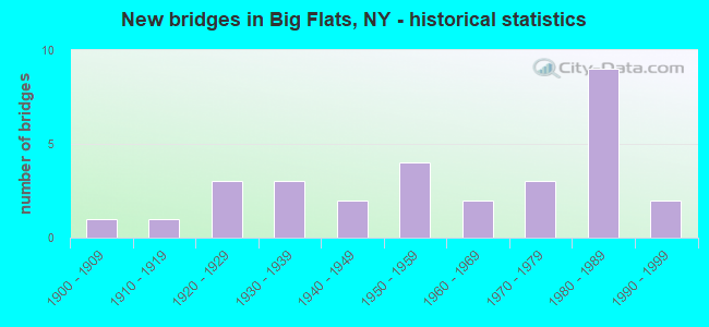
- New bridges - historical statistics
- 11900-1909
- 11910-1919
- 31920-1929
- 31930-1939
- 21940-1949
- 41950-1959
- 21960-1969
- 31970-1979
- 91980-1989
- 21990-1999

- Reconstructed bridges - Historical Statistics
- 11970-1979
- 61980-1989
- 61990-1999
- 02000-2009
- 12010-2019


- Bridge Condition - Deck
- 4.8%Excellent
- 14.3%Very good
- 38.1%Good
- 42.9%Satisfactory

- Bridge Condition - Superstructure
- 4.8%Excellent
- 14.3%Very good
- 42.9%Good
- 33.3%Satisfactory
- 4.8%Fair

- Bridge Condition - Substructure
- 9.5%Good
- 23.8%Satisfactory
- 57.1%Fair
- 9.5%Poor

- Bridge Condition - Channel
- 10.5%Good
- 52.6%Satisfactory
- 26.3%Fair
- 10.5%Poor

- Bridge Condition - Culverts
- 33.3%Good
- 33.3%Satisfactory
- 33.3%Fair
Find on map >> Show street view
Structure Number: 101274, Location: SR 352 OVER I86 (Lat: 42.127006, Lng: -76.981328), Route carried "on" structure: State highway 352, Year Built: 1985, Status: Open, Structure Length: 7.01m (23.00ft), Average Daily Traffic: 4,646 (year 2018), Truck Traffic: 5%, Average Future Daily Traffic: 4,667 (year 2040), Design Load: HS 20, Features Intersected: 86I 17 64043142, RTE I86
Minimum Vertical Clearance: 30+ m (98+ ft), Kilometerpoint: 9.976, Lanes on structure: 4, Lanes under structure: 4, Base Highway Network: Yes, Owner: State Highway Agency, Approaching Roadway Width: 18.6m (61.0ft), Skew: 1 degrees, Material/Design: Steel continuous, Design/Construction: Stringer/Multi-beam, Number Of Spans In Main Unit: 2, Length of Maximum Span: 34.4m (112.9ft), Curb-To-Curb Width: 18.3m (60.0ft), Out-to-Out Width: 19.2m (63.0ft)
Condition: Deck: Good, Superstructure: Good, Substructure: Satisfactory, Operating Rating: 88.0 metric tons, Method Used To Determine Operating Rating: Load Factor (LF), Inventory Rating: 52.6 metric tons, Method Used To Determine Inventory Rating: Load Factor (LF), Structural Evaluation: Equal to present minimum criteria, Deck Geometry: Somewhat better than minimum adequacy, Underclear: Somewhat better than minimum adequacy, Approach Roadway Alignment: Equal to present desirable criteria, Length Of Structure Improvement: 7.01m (23.00ft), Designated Inspection Frequency: Every 24 months, Inspection Date: June 2020, Bridge Improvement Cost: $3,652,000, Roadway Improvement Cost: $2,139,000, Total Project Cost: $5,791,000 ( Estimate for 2021), Deck Structure Type: Concrete Cast-file-Place, Wearing Surface/Protective System: Wearing Surface: Integral Concrete, Deck Protection: Epoxy Coated Reinforcing
Find on map >> Show street view
Structure Number: 101275, Location: 0.7 MI NE JCT RTE 17 + CL (Lat: 42.137875, Lng: -76.953242), Route carried "on" structure: Interstate 86, Year Built: 1956, Status: Open, Structure Length: 0.82m (2.69ft), Average Daily Traffic: 30,313 (year 2018), Truck Traffic: 13%, Average Future Daily Traffic: 46,533 (year 2040), Design Load: HS 20+Mod, Features Intersected: WINFIELD CREEK
Minimum Vertical Clearance: 30+ m (98+ ft), Kilometerpoint: 1.126, Lanes on structure: 4, Base Highway Network: Yes, Owner: State Highway Agency, Approaching Roadway Width: 29.3m (96.1ft), Skew: 23 degrees, Material/Design: Concrete, Design/Construction: Culvert, Number Of Spans In Main Unit: 2, Length of Maximum Span: 3.4m (11.2ft), Curb-To-Curb Width: 29.3m (96.1ft), Out-to-Out Width: 30.8m (101.0ft)
Condition: Channel: Satisfactory, Culverts: Satisfactory, Operating Rating: 96.2 metric tons, Method Used To Determine Operating Rating: Load Factor (LF), Inventory Rating: 58.1 metric tons, Method Used To Determine Inventory Rating: Load Factor (LF), Structural Evaluation: Equal to present minimum criteria, Deck Geometry: Superior to present desirable criteria, Waterway Adequacy: Equal to present minimum criteria, Approach Roadway Alignment: Equal to present desirable criteria, Length Of Structure Improvement: 0.70m (2.30ft), Designated Inspection Frequency: Every 24 months, Inspection Date: March 2021, Bridge Improvement Cost: $1,221,000, Roadway Improvement Cost: $715,000, Total Project Cost: $1,936,000 ( Estimate for 2021), Wearing Surface/Protective System: Wearing Surface: Bituminous
Find on map >> Show street view
Structure Number: 1012771, Location: 2.2 MI NE JCT RTE 17 + CL (Lat: 42.146208, Lng: -76.923897), Route carried "on" structure: Interstate 86, Year Built: 1956, Year Reconstructed: 1994, Status: Open, Structure Length: 1.58m (5.18ft), Average Daily Traffic: 15,552 (year 2008), Truck Traffic: 17%, Design Load: HS 20+Mod, Features Intersected: GUTHRIE RUN
Minimum Vertical Clearance: 30+ m (98+ ft), Kilometerpoint: 3.701, Lanes on structure: 2, Base Highway Network: Yes, Owner: State Highway Agency, Approaching Roadway Width: 10.7m (35.1ft), Skew: 4 degrees, Material/Design: Steel, Design/Construction: Stringer/Multi-beam, Number Of Spans In Main Unit: 1, Length of Maximum Span: 14.3m (46.9ft), Curb-To-Curb Width: 11.9m (39.0ft), Out-to-Out Width: 12.5m (41.0ft)
Condition: Deck: Satisfactory, Superstructure: Satisfactory, Substructure: Fair, Channel: Satisfactory, Operating Rating: 86.2 metric tons, Method Used To Determine Operating Rating: Load Factor (LF), Inventory Rating: 54.4 metric tons, Method Used To Determine Inventory Rating: Load Factor (LF), Structural Evaluation: Somewhat better than minimum adequacy, Deck Geometry: Equal to present minimum criteria, Waterway Adequacy: High priority of corrective action, Approach Roadway Alignment: Equal to present desirable criteria, Length Of Structure Improvement: 1.58m (5.18ft), Designated Inspection Frequency: Every 24 months, Inspection Date: November 2021, Bridge Improvement Cost: $1,082,000, Roadway Improvement Cost: $633,000, Total Project Cost: $1,715,000 ( Estimate for 2021), Deck Structure Type: Concrete Cast-file-Place, Wearing Surface/Protective System: Wearing Surface: Integral Concrete, Deck Protection: Epoxy Coated Reinforcing
Find on map >> Show street view
Structure Number: 1012772, Location: 2.2 MI NE JCT RTE 17 + CL (Lat: 42.146025, Lng: -76.923989), Route carried "on" structure: Interstate 86, Year Built: 1956, Year Reconstructed: 1994, Status: Open, Structure Length: 1.58m (5.18ft), Average Daily Traffic: 13,653 (year 2020), Truck Traffic: 15%, Average Future Daily Traffic: 20,958 (year 2040), Design Load: HS 20+Mod, Features Intersected: GUTHRIE RUN
Minimum Vertical Clearance: 30+ m (98+ ft), Kilometerpoint: 3.701, Lanes on structure: 2, Base Highway Network: Yes, Owner: State Highway Agency, Approaching Roadway Width: 11.0m (36.1ft), Skew: 4 degrees, Material/Design: Steel, Design/Construction: Stringer/Multi-beam, Number Of Spans In Main Unit: 1, Length of Maximum Span: 14.3m (46.9ft), Curb-To-Curb Width: 12.2m (40.0ft), Out-to-Out Width: 12.8m (42.0ft)
Condition: Deck: Satisfactory, Superstructure: Satisfactory, Substructure: Fair, Channel: Satisfactory, Operating Rating: 86.2 metric tons, Method Used To Determine Operating Rating: Load Factor (LF), Inventory Rating: 54.4 metric tons, Method Used To Determine Inventory Rating: Load Factor (LF), Structural Evaluation: Somewhat better than minimum adequacy, Deck Geometry: Better than present minimum criteria, Waterway Adequacy: Equal to present minimum criteria, Approach Roadway Alignment: Equal to present desirable criteria, Length Of Structure Improvement: 1.58m (5.18ft), Designated Inspection Frequency: Every 24 months, Inspection Date: November 2021, Bridge Improvement Cost: $1,108,000, Roadway Improvement Cost: $649,000, Total Project Cost: $1,757,000 ( Estimate for 2021), Deck Structure Type: Concrete Cast-file-Place, Wearing Surface/Protective System: Wearing Surface: Integral Concrete, Deck Protection: Epoxy Coated Reinforcing
Find on map >> Show street view
Structure Number: 104628, Location: .1 MI SE JCT SR17 & SR352 (Lat: 42.126108, Lng: -76.980350), Route carried "on" structure: State highway 352, Year Built: 1985, Status: Open, Structure Length: 4.82m (15.81ft), Average Daily Traffic: 4,646 (year 2018), Truck Traffic: 5%, Average Future Daily Traffic: 4,667 (year 2040), Design Load: HS 20, Features Intersected: NORFOLK SOUTHERN
Minimum Vertical Clearance: 30+ m (98+ ft), Kilometerpoint: 10.137, Lanes on structure: 4, Base Highway Network: Yes, Owner: State Highway Agency, Approaching Roadway Width: 18.6m (61.0ft), Skew: 2 degrees, Material/Design: Steel continuous, Design/Construction: Stringer/Multi-beam, Number Of Spans In Main Unit: 3, Length of Maximum Span: 20.1m (65.9ft), Curb-To-Curb Width: 18.4m (60.4ft), Out-to-Out Width: 19.4m (63.6ft)
Condition: Deck: Satisfactory, Superstructure: Good, Substructure: Satisfactory, Operating Rating: 80.7 metric tons, Method Used To Determine Operating Rating: Load Factor (LF), Inventory Rating: 51.7 metric tons, Method Used To Determine Inventory Rating: Load Factor (LF), Structural Evaluation: Equal to present minimum criteria, Deck Geometry: Somewhat better than minimum adequacy, Underclear: Better than present minimum criteria, Approach Roadway Alignment: Equal to present desirable criteria, Length Of Structure Improvement: 4.81m (15.78ft), Designated Inspection Frequency: Every 24 months, Inspection Date: June 2020, Bridge Improvement Cost: $2,774,000, Roadway Improvement Cost: $1,625,000, Total Project Cost: $4,399,000 ( Estimate for 2021), Deck Structure Type: Concrete Cast-file-Place, Wearing Surface/Protective System: Wearing Surface: Integral Concrete, Deck Protection: Epoxy Coated Reinforcing
Find on map >> Show street view
Structure Number: 104631, Location: 2.1 MI SE BIG FLATS (Lat: 42.104239, Lng: -76.921839), Route carried "on" structure: Alternate State highway 352, Year Built: 1932, Year Reconstructed: 1975, Status: Open, Structure Length: 1.55m (5.09ft), Average Daily Traffic: 5,275 (year 2018), Truck Traffic: 4%, Average Future Daily Traffic: 5,325 (year 2040), Design Load: H 20, Features Intersected: SINGSING CREEK
Minimum Vertical Clearance: 30+ m (98+ ft), Kilometerpoint: 5.969, Lanes on structure: 2, Base Highway Network: Yes, Owner: State Highway Agency, Approaching Roadway Width: 12.2m (40.0ft), Skew: 4 degrees, Material/Design: Concrete, Design/Construction: Culvert, Number Of Spans In Main Unit: 2, Length of Maximum Span: 7.3m (24.0ft)
Condition: Channel: Fair, Culverts: Fair, Operating Rating: 73.0 metric tons, Method Used To Determine Operating Rating: Field evaluation and documented engineering judgment, Inventory Rating: 19.6 metric tons, Method Used To Determine Inventory Rating: Field evaluation and documented engineering judgment, Structural Evaluation: Meets minimum limits, Waterway Adequacy: Equal to present desirable criteria, Approach Roadway Alignment: Equal to present desirable criteria, Length Of Structure Improvement: 1.55m (5.09ft), Designated Inspection Frequency: Every 24 months, Inspection Date: March 2020, Bridge Improvement Cost: $1,146,000, Roadway Improvement Cost: $671,000, Total Project Cost: $1,817,000 ( Estimate for 2021), Wearing Surface/Protective System: Wearing Surface: Bituminous
Find on map >> Show street view
Structure Number: 107287, Location: 0.5M N-BIG FLATS OVER STE (Lat: 42.141150, Lng: -76.941722), Route carried "on" structure: Ramp Other road , Year Built: 1985, Status: Open, Structure Length: 5.70m (18.70ft), Average Daily Traffic: 4,016 (year 2020), Truck Traffic: 2%, Average Future Daily Traffic: 4,968 (year 2040), Design Load: HS 20, Features Intersected: 86I 17 62051013, RTE I86, Facility Carried by Structure: Olcott Rd.
Minimum Vertical Clearance: 30+ m (98+ ft), Kilometerpoint: 0.145, Lanes on structure: 4, Lanes under structure: 4, Owner: State Highway Agency, Approaching Roadway Width: 17.4m (57.1ft), Material/Design: Steel continuous, Design/Construction: Stringer/Multi-beam, Number Of Spans In Main Unit: 2, Length of Maximum Span: 27.7m (90.9ft), Curb or Sidewalk Widths: Left: 0.0m, Right: 4.1m (13.5ft), Curb-To-Curb Width: 17.1m (56.1ft), Out-to-Out Width: 22.3m (73.2ft)
Condition: Deck: Satisfactory, Superstructure: Good, Substructure: Fair, Operating Rating: 88.0 metric tons, Method Used To Determine Operating Rating: Load Factor (LF), Inventory Rating: 51.7 metric tons, Method Used To Determine Inventory Rating: Load Factor (LF), Structural Evaluation: Somewhat better than minimum adequacy, Deck Geometry: Somewhat better than minimum adequacy, Underclear: Equal to present minimum criteria, Approach Roadway Alignment: Equal to present desirable criteria, Length Of Structure Improvement: 5.69m (18.67ft), Designated Inspection Frequency: Every 24 months, Inspection Date: September 2020, Bridge Improvement Cost: $3,557,000, Roadway Improvement Cost: $2,083,000, Total Project Cost: $5,640,000 ( Estimate for 2021), Deck Structure Type: Concrete Cast-file-Place, Wearing Surface/Protective System: Wearing Surface: Integral Concrete, Deck Protection: Epoxy Coated Reinforcing
Find on map >> Show street view
Structure Number: 107288, Location: 5 MI SOUTHEAST OF CORNING (Lat: 42.123808, Lng: -76.988747), Route carried "on" structure: Interstate 86, Year Built: 1986, Status: Open, Structure Length: 1.89m (6.20ft), Average Daily Traffic: 27,820 (year 2020), Truck Traffic: 19%, Average Future Daily Traffic: 51,900 (year 2040), Design Load: HS 20, Features Intersected: NORFOLK SOUTHERN
Minimum Vertical Clearance: 30+ m (98+ ft), Kilometerpoint: 83.411, Lanes on structure: 4, Base Highway Network: Yes, Owner: State Highway Agency, Approaching Roadway Width: 26.8m (87.9ft), Skew: 27 degrees, Material/Design: Prestressed concrete, Design/Construction: Box Beam or Girders - Multiple, Number Of Spans In Main Unit: 1, Length of Maximum Span: 17.6m (57.7ft), Curb-To-Curb Width: 26.2m (86.0ft), Out-to-Out Width: 172.8m (566.9ft)
Condition: Deck: Satisfactory, Superstructure: Satisfactory, Substructure: Fair, Operating Rating: 61.7 metric tons, Method Used To Determine Operating Rating: Load Factor (LF), Inventory Rating: 36.3 metric tons, Method Used To Determine Inventory Rating: Load Factor (LF), Structural Evaluation: Somewhat better than minimum adequacy, Deck Geometry: Superior to present desirable criteria, Underclear: Somewhat better than minimum adequacy, Approach Roadway Alignment: Equal to present desirable criteria, Length Of Structure Improvement: 1.88m (6.17ft), Designated Inspection Frequency: Every 24 months, Inspection Date: September 2020, Bridge Improvement Cost: $53,363,000, Roadway Improvement Cost: $31,249,000, Total Project Cost: $84,612,000 ( Estimate for 2021), Wearing Surface/Protective System: Wearing Surface: Bituminous
Find on map >> Show street view
Structure Number: 107374, Location: JCT CO RD 17 & I86 (Lat: 42.145778, Lng: -76.925419), Route carried "on" structure: County highway , Year Built: 1987, Status: Open, Structure Length: 7.10m (23.29ft), Average Daily Traffic: 2,356 (year 2017), Truck Traffic: 3%, Average Future Daily Traffic: 2,915 (year 2040), Design Load: HS 20, Features Intersected: 86I 17 62051022, RTE I86, Facility Carried by Structure: CR17- Hibbard Rd.
Minimum Vertical Clearance: 30+ m (98+ ft), Kilometerpoint: 1.673, Lanes on structure: 2, Lanes under structure: 4, Owner: State Highway Agency, Approaching Roadway Width: 10.4m (34.1ft), Skew: 3 degrees, Material/Design: Steel continuous, Design/Construction: Stringer/Multi-beam, Number Of Spans In Main Unit: 2, Length of Maximum Span: 35.3m (115.8ft), Curb-To-Curb Width: 10.2m (33.5ft), Out-to-Out Width: 11.2m (36.7ft)
Condition: Deck: Good, Superstructure: Satisfactory, Substructure: Satisfactory, Operating Rating: 64.4 metric tons, Method Used To Determine Operating Rating: Load Factor (LF), Inventory Rating: 38.1 metric tons, Method Used To Determine Inventory Rating: Load Factor (LF), Structural Evaluation: Equal to present minimum criteria, Deck Geometry: Meets minimum limits, Underclear: Meets minimum limits, Approach Roadway Alignment: Equal to present desirable criteria, Length Of Structure Improvement: 7.10m (23.29ft), Designated Inspection Frequency: Every 24 months, Inspection Date: August 2020, Bridge Improvement Cost: $2,185,000, Roadway Improvement Cost: $1,280,000, Total Project Cost: $3,465,000 ( Estimate for 2021), Deck Structure Type: Concrete Cast-file-Place, Wearing Surface/Protective System: Wearing Surface: Integral Concrete, Deck Protection: Epoxy Coated Reinforcing
Find on map >> Show street view
Structure Number: 221755, Location: 07 MI N E CORNING (Lat: 42.134844, Lng: -76.987894), Route carried "on" structure: Alternate Other road , Year Built: 1977, Status: Open, Structure Length: 0.73m (2.40ft), Average Daily Traffic: 276 (year 2018), Truck Traffic: 3%, Average Future Daily Traffic: 386 (year 2038), Design Load: H 20, Features Intersected: WINFIELD CREEK, Facility Carried by Structure: HICKORY LANE
Minimum Vertical Clearance: 30+ m (98+ ft), Kilometerpoint: 0.064, Lanes on structure: 2, Owner: Town or Township Highway Agency, Approaching Roadway Width: 6.1m (20.0ft), Skew: 3 degrees, Material/Design: Wood or Timber, Design/Construction: Stringer/Multi-beam, Number Of Spans In Main Unit: 1, Length of Maximum Span: 6.7m (22.0ft), Curb-To-Curb Width: 8.1m (26.6ft), Out-to-Out Width: 8.4m (27.6ft)
Condition: Deck: Good, Superstructure: Good, Substructure: Satisfactory, Channel: Satisfactory, Operating Rating: 40.8 metric tons, Method Used To Determine Operating Rating: Load Factor (LF), Inventory Rating: 29.9 metric tons, Method Used To Determine Inventory Rating: Load Factor (LF), Structural Evaluation: Equal to present minimum criteria, Deck Geometry: Somewhat better than minimum adequacy, Waterway Adequacy: Somewhat better than minimum adequacy, Approach Roadway Alignment: Superior to present desirable criteria, Length Of Structure Improvement: 0.73m (2.40ft), Designated Inspection Frequency: Every 24 months, Inspection Date: September 2021, Bridge Improvement Cost: $302,000, Roadway Improvement Cost: $177,000, Total Project Cost: $479,000 ( Estimate for 2021), Deck Structure Type: Wood or Timber, Wearing Surface/Protective System: Wearing Surface: Bituminous
Find on map >> Show street view
Structure Number: 225585, Location: IN BIG FLATS (Lat: 42.143456, Lng: -76.965644), Route carried "on" structure: Other road , Year Built: 1976, Year Reconstructed: 1991, Status: Open, Structure Length: 0.98m (3.22ft), Average Daily Traffic: 786 (year 2020), Truck Traffic: 2%, Average Future Daily Traffic: 1,100 (year 2040), Design Load: HS 20, Features Intersected: TRIB CHEMUNG R, Facility Carried by Structure: DAVENPORT RD
Minimum Vertical Clearance: 30+ m (98+ ft), Kilometerpoint: 0.032, Lanes on structure: 2, Owner: Town or Township Highway Agency, Approaching Roadway Width: 8.5m (27.9ft), Skew: 5 degrees, Material/Design: Wood or Timber, Design/Construction: Slab, Number Of Spans In Main Unit: 1, Length of Maximum Span: 8.8m (28.9ft), Curb-To-Curb Width: 8.2m (26.9ft), Out-to-Out Width: 8.5m (27.9ft)
Condition: Deck: Good, Superstructure: Good, Substructure: Poor, Channel: Satisfactory, Operating Rating: 68.0 metric tons, Method Used To Determine Operating Rating: Load Factor (LF), Inventory Rating: 48.1 metric tons, Method Used To Determine Inventory Rating: Load Factor (LF), Structural Evaluation: Meets minimum limits, Deck Geometry: Somewhat better than minimum adequacy, Waterway Adequacy: Somewhat better than minimum adequacy, Approach Roadway Alignment: Somewhat better than minimum adequacy, Length Of Structure Improvement: 0.97m (3.18ft), Designated Inspection Frequency: Every 24 months, Inspection Date: May 2020, Bridge Improvement Cost: $526,000, Roadway Improvement Cost: $308,000, Total Project Cost: $834,000 ( Estimate for 2021), Deck Structure Type: Wood or Timber, Wearing Surface/Protective System: Wearing Surface: Bituminous
Find on map >> Show street view
Structure Number: 226676, Location: 0.6MI N.BIG FLATS-ADJRT17 (Lat: 42.142078, Lng: -76.944353), Route carried "on" structure: Other road , Year Built: 1985, Year Reconstructed: 2019, Status: Open, Structure Length: 3.14m (10.30ft), Average Daily Traffic: 2,270 (year 2020), Truck Traffic: 5%, Average Future Daily Traffic: 2,808 (year 2040), Design Load: HS 20, Features Intersected: OWENS HOLLOW CREK, Facility Carried by Structure: DANIEL ZENKER DR
Minimum Vertical Clearance: 30+ m (98+ ft), Kilometerpoint: 1.352, Lanes on structure: 2, Owner: Town or Township Highway Agency, Approaching Roadway Width: 14.6m (47.9ft), Skew: 2 degrees, Material/Design: Prestressed concrete, Design/Construction: Box Beam or Girders - Multiple, Number Of Spans In Main Unit: 1, Length of Maximum Span: 29.8m (97.8ft), Curb-To-Curb Width: 14.6m (47.9ft), Out-to-Out Width: 15.3m (50.2ft)
Condition: Deck: Excellent, Superstructure: Good, Substructure: Good, Channel: Good, Operating Rating: 88.9 metric tons, Method Used To Determine Operating Rating: Load Factor (LF), Inventory Rating: 44.5 metric tons, Method Used To Determine Inventory Rating: Load Factor (LF), Structural Evaluation: Better than present minimum criteria, Deck Geometry: Superior to present desirable criteria, Waterway Adequacy: Equal to present minimum criteria, Approach Roadway Alignment: Equal to present desirable criteria, Length Of Structure Improvement: 3.04m (9.97ft), Designated Inspection Frequency: Every 24 months, Inspection Date: December 2021, Bridge Improvement Cost: $1,244,000, Roadway Improvement Cost: $728,000, Total Project Cost: $1,972,000 ( Estimate for 2021), Deck Structure Type: Concrete Cast-file-Place, Wearing Surface/Protective System: Wearing Surface: Monolithic Concrete, Deck Protection: Epoxy Coated Reinforcing
Find on map >> Show street view
Structure Number: 333098, Location: 1.5 MI SW OF BIG FLATS (Lat: 42.123617, Lng: -76.954114), Route carried "on" structure: County highway , Year Built: 1960, Year Reconstructed: 1987, Status: Open, Structure Length: 18.04m (59.19ft), Average Daily Traffic: 2,947 (year 2020), Truck Traffic: 3%, Average Future Daily Traffic: 3,074 (year 2040), Design Load: HS 20+Mod, Features Intersected: CHEMUNG RIVER, Facility Carried by Structure: CR10 S CORNING RD
Minimum Vertical Clearance: 30+ m (98+ ft), Kilometerpoint: 1.014, Lanes on structure: 2, Owner: County Highway Agency, Approaching Roadway Width: 9.1m (29.9ft), Skew: 1 degrees, Material/Design: Steel, Design/Construction: Stringer/Multi-beam, Number Of Spans In Main Unit: 5, Length of Maximum Span: 35.9m (117.8ft), Curb-To-Curb Width: 9.1m (29.9ft), Out-to-Out Width: 9.8m (32.2ft)
Condition: Deck: Satisfactory, Superstructure: Fair, Substructure: Fair, Channel: Good, Operating Rating: 95.6 metric tons, Method Used To Determine Operating Rating: Field evaluation and documented engineering judgment, Inventory Rating: 29.4 metric tons, Method Used To Determine Inventory Rating: Field evaluation and documented engineering judgment, Structural Evaluation: Somewhat better than minimum adequacy, Deck Geometry: Meets minimum limits, Waterway Adequacy: Equal to present desirable criteria, Approach Roadway Alignment: Equal to present desirable criteria, Length Of Structure Improvement: 18.04m (59.19ft), Designated Inspection Frequency: Every 24 months, Underwater Inspection Frequency: Every 60 months, Inspection Date: July 2021, Underwater Inspection Date: June 2021, Bridge Improvement Cost: $4,325,000, Roadway Improvement Cost: $2,533,000, Total Project Cost: $6,858,000 ( Estimate for 2021), Deck Structure Type: Concrete Cast-file-Place, Wearing Surface/Protective System: Wearing Surface: Integral Concrete, Deck Protection: Epoxy Coated Reinforcing
Find on map >> Show street view
Structure Number: 333133, Location: 0.6 MI N OF BIG FLATS (Lat: 42.143989, Lng: -76.939003), Route carried "on" structure: Other road , Year Built: 1934, Year Reconstructed: 2002, Status: Open, Structure Length: 0.85m (2.79ft), Average Daily Traffic: 988 (year 2020), Truck Traffic: 2%, Average Future Daily Traffic: 1,222 (year 2040), Features Intersected: TRIB CHEMUNG RIVR, Facility Carried by Structure: HILLVIEW DR
Minimum Vertical Clearance: 30+ m (98+ ft), Kilometerpoint: 0.177, Lanes on structure: 2, Owner: County Highway Agency, Approaching Roadway Width: 7.3m (24.0ft), Material/Design: Wood or Timber, Design/Construction: Stringer/Multi-beam, Number Of Spans In Main Unit: 1, Length of Maximum Span: 8.2m (26.9ft), Curb-To-Curb Width: 8.0m (26.2ft), Out-to-Out Width: 8.6m (28.2ft)
Condition: Deck: Very good, Superstructure: Excellent, Substructure: Satisfactory, Channel: Fair, Operating Rating: 69.0 metric tons, Method Used To Determine Operating Rating: Field evaluation and documented engineering judgment, Inventory Rating: 29.8 metric tons, Method Used To Determine Inventory Rating: Field evaluation and documented engineering judgment, Structural Evaluation: Equal to present minimum criteria, Deck Geometry: Somewhat better than minimum adequacy, Waterway Adequacy: Equal to present minimum criteria, Approach Roadway Alignment: Equal to present minimum criteria, Length Of Structure Improvement: 0.85m (2.79ft), Designated Inspection Frequency: Every 24 months, Inspection Date: July 2020, Bridge Improvement Cost: $263,000, Roadway Improvement Cost: $154,000, Total Project Cost: $417,000 ( Estimate for 2021), Deck Structure Type: Wood or Timber, Wearing Surface/Protective System: Wearing Surface: Bituminous, Membrane: Other
Find on map >> Show street view
Structure Number: 333143, Location: IN BIG FLATS (Lat: 42.133792, Lng: -76.943014), Route carried "on" structure: County highway , Year Built: 1924, Year Reconstructed: 1995, Status: Open, Structure Length: 1.01m (3.31ft), Average Daily Traffic: 4,573 (year 2017), Truck Traffic: 4%, Average Future Daily Traffic: 5,555 (year 2040), Design Load: HS 20, Features Intersected: TRB CHEMUNG RIVER, Facility Carried by Structure: CR64 MAIN ST
Minimum Vertical Clearance: 30+ m (98+ ft), Kilometerpoint: 0.080, Lanes on structure: 2, Owner: County Highway Agency, Approaching Roadway Width: 6.7m (22.0ft), Material/Design: Prestressed concrete, Design/Construction: Box Beam or Girders - Multiple, Number Of Spans In Main Unit: 1, Length of Maximum Span: 9.4m (30.8ft), Curb-To-Curb Width: 8.0m (26.2ft), Out-to-Out Width: 8.7m (28.5ft)
Condition: Deck: Very good, Superstructure: Very good, Substructure: Fair, Channel: Poor, Operating Rating: 70.8 metric tons, Method Used To Determine Operating Rating: Load Factor (LF), Inventory Rating: 41.7 metric tons, Method Used To Determine Inventory Rating: Load Factor (LF), Structural Evaluation: Somewhat better than minimum adequacy, Deck Geometry: High priority of corrective action, Waterway Adequacy: Equal to present minimum criteria, Approach Roadway Alignment: Equal to present desirable criteria, Length Of Structure Improvement: 1.00m (3.28ft), Designated Inspection Frequency: Every 24 months, Inspection Date: April 2021, Bridge Improvement Cost: $362,000, Roadway Improvement Cost: $212,000, Total Project Cost: $573,000 ( Estimate for 2021), Wearing Surface/Protective System: Wearing Surface: Bituminous, Membrane: Other
Find on map >> Show street view
Structure Number: 333144, Location: 0.4 MI SE OF BIG FLATS (Lat: 42.134708, Lng: -76.927825), Route carried "on" structure: County highway , Year Built: 1924, Year Reconstructed: 1995, Status: Open, Structure Length: 1.16m (3.81ft), Average Daily Traffic: 5,692 (year 2020), Truck Traffic: 4%, Average Future Daily Traffic: 6,914 (year 2040), Design Load: HS 20, Features Intersected: CUTHRIE RUN, Facility Carried by Structure: CR64 MAIN ST
Minimum Vertical Clearance: 30+ m (98+ ft), Kilometerpoint: 1.335, Lanes on structure: 2, Owner: County Highway Agency, Approaching Roadway Width: 6.4m (21.0ft), Material/Design: Prestressed concrete, Design/Construction: Box Beam or Girders - Multiple, Number Of Spans In Main Unit: 1, Length of Maximum Span: 10.3m (33.8ft), Curb-To-Curb Width: 9.9m (32.5ft), Out-to-Out Width: 10.5m (34.4ft)
Condition: Deck: Very good, Superstructure: Very good, Substructure: Fair, Channel: Satisfactory, Operating Rating: 72.6 metric tons, Method Used To Determine Operating Rating: Load Factor (LF), Inventory Rating: 43.5 metric tons, Method Used To Determine Inventory Rating: Load Factor (LF), Structural Evaluation: Somewhat better than minimum adequacy, Deck Geometry: Meets minimum limits, Waterway Adequacy: Equal to present minimum criteria, Approach Roadway Alignment: Equal to present desirable criteria, Length Of Structure Improvement: 1.15m (3.77ft), Designated Inspection Frequency: Every 24 months, Inspection Date: April 2021, Bridge Improvement Cost: $458,000, Roadway Improvement Cost: $268,000, Total Project Cost: $727,000 ( Estimate for 2021), Wearing Surface/Protective System: Wearing Surface: Bituminous, Membrane: Other
Find on map >> Show street view
Structure Number: 333145, Location: 1.5 MILE EAST OF BIGFLATS (Lat: 42.140986, Lng: -76.907075), Route carried "on" structure: ServiceCounty highway , Year Built: 1924, Year Reconstructed: 1992, Status: Open, Structure Length: 1.16m (3.81ft), Average Daily Traffic: 5,692 (year 2020), Truck Traffic: 4%, Average Future Daily Traffic: 6,914 (year 2040), Design Load: HS 20, Features Intersected: SINGSING CREEK, Facility Carried by Structure: CR64 MAIN ST
Minimum Vertical Clearance: 30+ m (98+ ft), Kilometerpoint: 3.234, Lanes on structure: 2, Owner: County Highway Agency, Approaching Roadway Width: 7.0m (23.0ft), Skew: 1 degrees, Material/Design: Prestressed concrete, Design/Construction: Box Beam or Girders - Multiple, Number Of Spans In Main Unit: 1, Length of Maximum Span: 10.6m (34.8ft), Curb-To-Curb Width: 9.2m (30.2ft), Out-to-Out Width: 9.8m (32.2ft)
Condition: Deck: Satisfactory, Superstructure: Satisfactory, Substructure: Fair, Channel: Poor, Operating Rating: 49.9 metric tons, Method Used To Determine Operating Rating: Load Factor (LF), Inventory Rating: 35.4 metric tons, Method Used To Determine Inventory Rating: Load Factor (LF), Structural Evaluation: Somewhat better than minimum adequacy, Deck Geometry: High priority of corrective action, Waterway Adequacy: Equal to present minimum criteria, Approach Roadway Alignment: Equal to present desirable criteria, Length Of Structure Improvement: 1.15m (3.77ft), Designated Inspection Frequency: Every 24 months, Inspection Date: April 2021, Bridge Improvement Cost: $372,000, Roadway Improvement Cost: $218,000, Total Project Cost: $590,000 ( Estimate for 2021), Wearing Surface/Protective System: Wearing Surface: Bituminous, Membrane: Other
Find on map >> Show street view
Structure Number: 333155, Location: 2.5 MI N OF BIG FLATS (Lat: 42.173811, Lng: -76.925103), Route carried "on" structure: Other road , Year Built: 1944, Year Reconstructed: 1997, Status: Open, Structure Length: 1.07m (3.51ft), Average Daily Traffic: 222 (year 2018), Truck Traffic: 3%, Average Future Daily Traffic: 311 (year 2038), Design Load: HS 25 or greater, Features Intersected: CUTHRIE RUN, Facility Carried by Structure: BREED HOLLOW ROAD
Minimum Vertical Clearance: 30+ m (98+ ft), Kilometerpoint: 0.965, Lanes on structure: 2, Owner: Town or Township Highway Agency, Approaching Roadway Width: 6.1m (20.0ft), Skew: 4 degrees, Material/Design: Wood or Timber, Design/Construction: Stringer/Multi-beam, Number Of Spans In Main Unit: 1, Length of Maximum Span: 9.7m (31.8ft), Curb-To-Curb Width: 7.3m (24.0ft), Out-to-Out Width: 7.9m (25.9ft)
Condition: Deck: Good, Superstructure: Good, Substructure: Fair, Channel: Fair, Operating Rating: 78.8 metric tons, Method Used To Determine Operating Rating: Field evaluation and documented engineering judgment, Inventory Rating: 36.7 metric tons, Method Used To Determine Inventory Rating: Field evaluation and documented engineering judgment, Structural Evaluation: Somewhat better than minimum adequacy, Deck Geometry: Somewhat better than minimum adequacy, Waterway Adequacy: Superior to present desirable criteria, Approach Roadway Alignment: Better than present minimum criteria, Length Of Structure Improvement: 1.06m (3.48ft), Designated Inspection Frequency: Every 24 months, Inspection Date: March 2021, Bridge Improvement Cost: $375,000, Roadway Improvement Cost: $220,000, Total Project Cost: $595,000 ( Estimate for 2021), Deck Structure Type: Wood or Timber, Wearing Surface/Protective System: Wearing Surface: Bituminous
Find on map >> Show street view
Structure Number: 333156, Location: 2.9 MI N OF BIG FLATS (Lat: 42.178850, Lng: -76.925175), Route carried "on" structure: Other road , Year Built: 1944, Year Reconstructed: 1997, Status: Open, Structure Length: 1.07m (3.51ft), Average Daily Traffic: 222 (year 2018), Truck Traffic: 3%, Average Future Daily Traffic: 311 (year 2038), Design Load: HS 25 or greater, Features Intersected: CUTHRIE RUN, Facility Carried by Structure: BREED HOLLOW ROAD
Minimum Vertical Clearance: 30+ m (98+ ft), Kilometerpoint: 1.545, Lanes on structure: 2, Owner: County Highway Agency, Approaching Roadway Width: 6.1m (20.0ft), Skew: 4 degrees, Material/Design: Wood or Timber, Design/Construction: Stringer/Multi-beam, Number Of Spans In Main Unit: 1, Length of Maximum Span: 10.0m (32.8ft), Curb-To-Curb Width: 7.3m (24.0ft), Out-to-Out Width: 7.9m (25.9ft)
Condition: Deck: Good, Superstructure: Very good, Substructure: Fair, Channel: Satisfactory, Operating Rating: 79.7 metric tons, Method Used To Determine Operating Rating: Field evaluation and documented engineering judgment, Inventory Rating: 40.8 metric tons, Method Used To Determine Inventory Rating: Field evaluation and documented engineering judgment, Structural Evaluation: Somewhat better than minimum adequacy, Deck Geometry: Somewhat better than minimum adequacy, Waterway Adequacy: Superior to present desirable criteria, Approach Roadway Alignment: Equal to present minimum criteria, Length Of Structure Improvement: 1.06m (3.48ft), Designated Inspection Frequency: Every 24 months, Inspection Date: March 2021, Bridge Improvement Cost: $377,000, Roadway Improvement Cost: $221,000, Total Project Cost: $597,000 ( Estimate for 2021), Deck Structure Type: Wood or Timber, Wearing Surface/Protective System: Wearing Surface: Bituminous
Find on map >> Show street view
Structure Number: 333157, Location: 3.4 MI N OF BIG FLATS (Lat: 42.184419, Lng: -76.927083), Route carried "on" structure: Other road , Year Built: 1962, Year Reconstructed: 1997, Status: Open, Structure Length: 0.82m (2.69ft), Average Daily Traffic: 222 (year 2018), Truck Traffic: 3%, Average Future Daily Traffic: 311 (year 2038), Design Load: HS 25 or greater, Features Intersected: CUTHRIE RUN, Facility Carried by Structure: BREED HOLLOW ROAD
Minimum Vertical Clearance: 30+ m (98+ ft), Kilometerpoint: 2.188, Lanes on structure: 2, Owner: County Highway Agency, Approaching Roadway Width: 5.5m (18.0ft), Skew: 3 degrees, Material/Design: Wood or Timber, Design/Construction: Slab, Number Of Spans In Main Unit: 1, Length of Maximum Span: 7.6m (24.9ft), Curb-To-Curb Width: 7.3m (24.0ft), Out-to-Out Width: 7.9m (25.9ft)
Condition: Deck: Good, Superstructure: Good, Substructure: Fair, Channel: Fair, Operating Rating: 89.8 metric tons, Method Used To Determine Operating Rating: Load Factor (LF), Inventory Rating: 73.5 metric tons, Method Used To Determine Inventory Rating: Load Factor (LF), Structural Evaluation: Somewhat better than minimum adequacy, Deck Geometry: Somewhat better than minimum adequacy, Waterway Adequacy: Superior to present desirable criteria, Approach Roadway Alignment: Equal to present minimum criteria, Length Of Structure Improvement: 0.82m (2.69ft), Designated Inspection Frequency: Every 24 months, Inspection Date: March 2021, Bridge Improvement Cost: $296,000, Roadway Improvement Cost: $173,000, Total Project Cost: $469,000 ( Estimate for 2021), Wearing Surface/Protective System: Wearing Surface: Bituminous
Find on map >> Show street view
Structure Number: 333161, Location: 1.2 MI SE OF BIG FLATS (Lat: 42.133658, Lng: -76.915553), Route carried "on" structure: Other road , Year Built: 1976, Status: Open, Structure Length: 2.62m (8.60ft), Average Daily Traffic: 602 (year 2018), Truck Traffic: 5%, Average Future Daily Traffic: 843 (year 2038), Design Load: HS 20, Features Intersected: SINGSING CREEK, Facility Carried by Structure: SUBURBAN DRIVE
Minimum Vertical Clearance: 30+ m (98+ ft), Kilometerpoint: 0.322, Lanes on structure: 2, Owner: County Highway Agency, Approaching Roadway Width: 7.3m (24.0ft), Material/Design: Steel, Design/Construction: Stringer/Multi-beam, Number Of Spans In Main Unit: 1, Length of Maximum Span: 24.9m (81.7ft), Curb-To-Curb Width: 9.1m (29.9ft), Out-to-Out Width: 9.8m (32.2ft)
Condition: Deck: Satisfactory, Superstructure: Satisfactory, Substructure: Fair, Channel: Fair, Operating Rating: 70.3 metric tons, Method Used To Determine Operating Rating: Load and Resistance Factor Rating (LRFR) rating reported by rating factor(RF) method using HL-93 loadings, Inventory Rating: 54.1 metric tons, Method Used To Determine Inventory Rating: Load and Resistance Factor Rating (LRFR) rating reported by rating factor(RF) method using HL-93 loadings, Structural Evaluation: Somewhat better than minimum adequacy, Deck Geometry: Equal to present minimum criteria, Waterway Adequacy: Meets minimum limits, Approach Roadway Alignment: Equal to present desirable criteria, Length Of Structure Improvement: 2.62m (8.60ft), Designated Inspection Frequency: Every 24 months, Inspection Date: July 2020, Bridge Improvement Cost: $661,000, Roadway Improvement Cost: $387,000, Total Project Cost: $1,049,000 ( Estimate for 2021), Deck Structure Type: Concrete Cast-file-Place, Wearing Surface/Protective System: Wearing Surface: Integral Concrete
Find on map >> Show street view
Structure Number: 333191, Location: 5.0 MI SEELEY CK (Lat: 42.074492, Lng: -76.940122), Route carried "on" structure: ServiceOther road , Year Built: 1952, Year Reconstructed: 1992, Status: Open, Structure Length: 0.98m (3.22ft), Average Daily Traffic: 159 (year 2018), Truck Traffic: 5%, Average Future Daily Traffic: 223 (year 2038), Design Load: HS 25 or greater, Features Intersected: HENDY CREEK, Facility Carried by Structure: CLARK HOLLOW ROAD
Minimum Vertical Clearance: 30+ m (98+ ft), Kilometerpoint: 6.597, Lanes on structure: 2, Owner: County Highway Agency, Approaching Roadway Width: 4.9m (16.1ft), Material/Design: Wood or Timber, Design/Construction: Slab, Number Of Spans In Main Unit: 1, Length of Maximum Span: 9.4m (30.8ft), Curb-To-Curb Width: 5.6m (18.4ft), Out-to-Out Width: 5.9m (19.4ft)
Condition: Deck: Satisfactory, Superstructure: Satisfactory, Substructure: Poor, Channel: Satisfactory, Operating Rating: 79.3 metric tons, Method Used To Determine Operating Rating: Field evaluation and documented engineering judgment, Inventory Rating: 40.8 metric tons, Method Used To Determine Inventory Rating: Field evaluation and documented engineering judgment, Structural Evaluation: Meets minimum limits, Deck Geometry: High priority of corrective action, Waterway Adequacy: Superior to present desirable criteria, Approach Roadway Alignment: Equal to present desirable criteria, Length Of Structure Improvement: 0.97m (3.18ft), Designated Inspection Frequency: Every 24 months, Inspection Date: April 2021, Bridge Improvement Cost: $229,000, Roadway Improvement Cost: $134,000, Total Project Cost: $363,000 ( Estimate for 2021), Wearing Surface/Protective System: Wearing Surface: Bituminous
Find on map >> Show street view
Structure Number: 336956, Location: 1.2 M SW REGIONAL AIRPORT (Lat: 42.151283, Lng: -76.918625), Route carried "on" structure: County highway , Year Built: 1998, Status: Open, Structure Length: 1.86m (6.10ft), Average Daily Traffic: 2,176 (year 2017), Truck Traffic: 4%, Average Future Daily Traffic: 2,692 (year 2040), Features Intersected: CUTHRIE RUN, Facility Carried by Structure: DANIEL ZENKER DRIV
Minimum Vertical Clearance: 30+ m (98+ ft), Kilometerpoint: 2.172, Lanes on structure: 2, Owner: County Highway Agency, Approaching Roadway Width: 16.5m (54.1ft), Skew: 23 degrees, Material/Design: Prestressed concrete, Design/Construction: Box Beam or Girders - Multiple, Number Of Spans In Main Unit: 1, Length of Maximum Span: 18.0m (59.1ft), Curb-To-Curb Width: 16.7m (54.8ft), Out-to-Out Width: 17.3m (56.8ft)
Condition: Deck: Good, Superstructure: Good, Substructure: Good, Channel: Satisfactory, Operating Rating: 78.9 metric tons, Method Used To Determine Operating Rating: Load Factor (LF), Inventory Rating: 43.5 metric tons, Method Used To Determine Inventory Rating: Load Factor (LF), Structural Evaluation: Better than present minimum criteria, Deck Geometry: Superior to present desirable criteria, Waterway Adequacy: Meets minimum limits, Approach Roadway Alignment: Better than present minimum criteria, Length Of Structure Improvement: 1.85m (6.07ft), Designated Inspection Frequency: Every 24 months, Inspection Date: April 2021, Bridge Improvement Cost: $1,424,000, Roadway Improvement Cost: $834,000, Total Project Cost: $2,257,000 ( Estimate for 2021), Wearing Surface/Protective System: Wearing Surface: Bituminous
Find on map >> Show street view
Structure Number: 336964, Location: 1.2 M W REGIONAL AIRPORT (Lat: 42.152106, Lng: -76.915625), Route carried "on" structure: County highway , Year Built: 1998, Status: Open, Structure Length: 0.82m (2.69ft), Average Daily Traffic: 2,176 (year 2017), Truck Traffic: 4%, Average Future Daily Traffic: 2,692 (year 2040), Design Load: HS 25 or greater, Features Intersected: TRIB CUTHRIE RUN, Facility Carried by Structure: DANIEL ZENKER DRIV
Minimum Vertical Clearance: 30+ m (98+ ft), Kilometerpoint: 2.462, Lanes on structure: 2, Owner: County Highway Agency, Approaching Roadway Width: 16.5m (54.1ft), Skew: 24 degrees, Material/Design: Concrete, Design/Construction: Culvert, Number Of Spans In Main Unit: 2, Length of Maximum Span: 3.7m (12.1ft)
Condition: Channel: Satisfactory, Culverts: Good, Operating Rating: 85.3 metric tons, Method Used To Determine Operating Rating: Load Factor (LF), Inventory Rating: 50.8 metric tons, Method Used To Determine Inventory Rating: Load Factor (LF), Structural Evaluation: Better than present minimum criteria, Waterway Adequacy: Somewhat better than minimum adequacy, Approach Roadway Alignment: Equal to present desirable criteria, Length Of Structure Improvement: 0.82m (2.69ft), Designated Inspection Frequency: Every 24 months, Inspection Date: April 2021, Bridge Improvement Cost: $294,000, Roadway Improvement Cost: $172,000, Total Project Cost: $466,000 ( Estimate for 2021)
Find on map >> Show street view
Structure Number: 101274, Location: SR 352 OVER I86 (Lat: 42.127006, Lng: -76.981328), Route carried "under" structure: Interstate 86, Year Built: 1985, Structure Length: 0. m, Average Daily Traffic: 8,164 (year 1999), Features Intersected: 86I 17 64043142, RTE I86, Facility Carried by Structure: RTE 352
Minimum Vertical Clearance: 5.05m (16.57ft), Kilometerpoint: 22.848, Lanes on structure: 4, Lanes under structure: 2, Material/Design: Steel continuous, Design/Construction: Stringer/Multi-beam, Length of Maximum Span: 34.4m (112.9ft)
Find on map >> Show street view
Structure Number: 107287, Location: 0.5M N-BIG FLATS OVER STE (Lat: 42.141150, Lng: -76.941722), Route carried "under" structure: Interstate 86, Year Built: 1985, Structure Length: 0. m, Average Daily Traffic: 6,010 (year 1999), Features Intersected: 86I 17 62051013, RTE I86, Facility Carried by Structure: Olcott Rd.
Minimum Vertical Clearance: 5.16m (16.93ft), Kilometerpoint: 2.092, Lanes on structure: 4, Lanes under structure: 2, Material/Design: Steel continuous, Design/Construction: Stringer/Multi-beam, Length of Maximum Span: 27.7m (90.9ft)
Find on map >> Show street view
Structure Number: 107374, Location: JCT CO RD 17 & I86 (Lat: 42.145778, Lng: -76.925419), Route carried "under" structure: Interstate 86, Year Built: 1987, Structure Length: 0. m, Average Daily Traffic: 20,600 (year 1985), Features Intersected: 86I 17 62051022, RTE I86, Facility Carried by Structure: CR17- Hibbard Rd.
Minimum Vertical Clearance: 5.23m (17.16ft), Kilometerpoint: 3.540, Lanes on structure: 2, Lanes under structure: 2, Material/Design: Steel continuous, Design/Construction: Stringer/Multi-beam, Length of Maximum Span: 35.3m (115.8ft)
Find on map >> Show street view
Structure Number: 733217, Location: IN BIG FLATS (Lat: 42.138675, Lng: -76.927917), Route carried "under" structure: ServiceOther road , Year Built: 1934, Structure Length: 0. m, Average Daily Traffic: 1,622 (year 2020), Truck Traffic: 2%, Features Intersected: WINTER STREET, Facility Carried by Structure: NORFOLK SOUTHERN
Minimum Vertical Clearance: 3.02m (9.91ft), Kilometerpoint: 0.000, Lanes under structure: 2, Material/Design: Steel, Design/Construction: Girder and Floorbeam System, Length of Maximum Span: 9.4m (30.8ft)
Find on map >> Show street view
Structure Number: 7332182, Location: IN BIG FLATS (Lat: 42.136394, Lng: -76.943350), Route carried "under" structure: Bypass Other road , Year Built: 1916, Structure Length: 0. m, Features Intersected: OLCOTT ROAD, NO NAME CRE, Facility Carried by Structure: NORFOLK SOUTHERN
Minimum Vertical Clearance: 3.84m (12.60ft), Kilometerpoint: 0.000, Lanes under structure: 2, Material/Design: Steel, Design/Construction: Girder and Floorbeam System, Length of Maximum Span: 19.5m (64.0ft)
Find on map >> Show street view
Structure Number: 7700142, Location: IN BIG FLATS (Lat: 42.137364, Lng: -76.937231), Route carried "under" structure: ServiceOther road , Year Built: 1900, Structure Length: 0. m, Average Daily Traffic: 997 (year 2020), Truck Traffic: 1%, Features Intersected: CANAL ST, Facility Carried by Structure: NORFOLK SOUTHERN
Minimum Vertical Clearance: 3.45m (11.32ft), Kilometerpoint: 0.000, Lanes under structure: 2, Material/Design: Steel, Design/Construction: Girder and Floorbeam System, Length of Maximum Span: 17.6m (57.7ft)