Bridge Statistics for Bigfork, Montana (MT)
Condition, Traffic, Stress, Structural Evaluation, Project Costs
- National Bridge Inventory (NBI) Statistics
- 10Number of bridges
- 203ft / 61.8mTotal length
- $2,408,000Total costs
- 29,362Total average daily traffic
- 358Total average daily truck traffic
- 31,972Total future (year 2037) average daily traffic
- National Bridge Inventory (NBI) Registered Bridges for Bigfork
- No street view available for this location
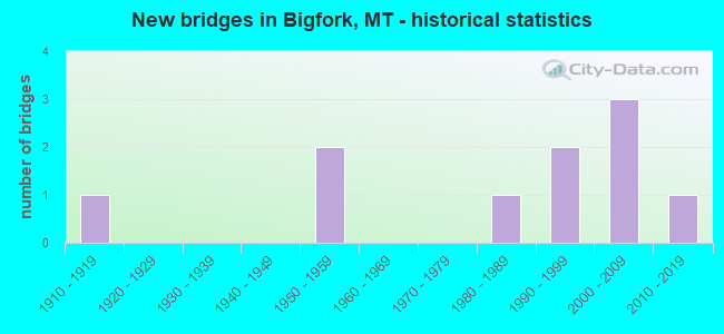
- New bridges - historical statistics
- 11910-1919
- 21950-1959
- 11980-1989
- 21990-1999
- 32000-2009
- 12010-2019


- Bridge Condition - Deck
- 30.0%Good
- 60.0%Satisfactory
- 10.0%Poor

- Bridge Condition - Superstructure
- 60.0%Good
- 10.0%Satisfactory
- 20.0%Fair
- 10.0%Poor

- Bridge Condition - Substructure
- 10.0%Very good
- 70.0%Good
- 10.0%Satisfactory
- 10.0%Fair

- Bridge Condition - Channel
- 20.0%Excellent
- 70.0%Very good
- 10.0%Satisfactory
Find on map >> Show street view
Structure Number: 6381, Location: 5M E BIG FORK (Lat: 48.051678, Lng: -113.982361), Route carried "on" structure: State highway 209, Year Built: 2018, Status: Open, Structure Length: 6.45m (21.16ft), Average Daily Traffic: 2,111 (year 2020), Truck Traffic: 1%, Average Future Daily Traffic: 2,238 (year 2040), Design Load: HL 93, Features Intersected: SWAN RIVER
Minimum Vertical Clearance: 30+ m (98+ ft), Kilometerpoint: 7.240, Lanes on structure: 2, Owner: State Highway Agency, Approaching Roadway Width: 12.2m (40.0ft), Material/Design: Steel, Design/Construction: Stringer/Multi-beam, Number Of Spans In Main Unit: 1, Length of Maximum Span: 62.6m (205.4ft), Curb-To-Curb Width: 12.2m (40.0ft), Out-to-Out Width: 13.2m (43.3ft)
Condition: Deck: Good, Superstructure: Good, Substructure: Very good, Channel: Very good, Operating Rating: 51.7 metric tons, Method Used To Determine Operating Rating: Load and Resistance Factor (LRFR), Inventory Rating: 39.9 metric tons, Method Used To Determine Inventory Rating: Load and Resistance Factor (LRFR), Structural Evaluation: Better than present minimum criteria, Deck Geometry: Equal to present minimum criteria, Waterway Adequacy: Equal to present desirable criteria, Approach Roadway Alignment: Equal to present desirable criteria, Designated Inspection Frequency: Every 24 months, Inspection Date: October 2020, Deck Structure Type: Concrete Cast-file-Place, Wearing Surface/Protective System: Wearing Surface: Monolithic Concrete, Deck Protection: Other
Find on map >> Show street view
Structure Number: L15096001+01001, Location: 1M SE CRESTON (Lat: 48.175447, Lng: -114.131861), Route carried "on" structure: County highway 15096, Year Built: 1989, Status: Open, Structure Length: 1.55m (5.09ft), Average Daily Traffic: 100 (year 2022), Truck Traffic: 3%, Average Future Daily Traffic: 100 (year 2037), Design Load: HS 20, Features Intersected: MILL CREEK 148, Facility Carried by Structure: RIVERSIDE RD
Minimum Vertical Clearance: 30+ m (98+ ft), Kilometerpoint: 1.807, Lanes on structure: 2, Owner: County Highway Agency, Approaching Roadway Width: 7.3m (24.0ft), Material/Design: Prestressed concrete, Design/Construction: Tee Beam, Number Of Spans In Main Unit: 1, Length of Maximum Span: 15.5m (50.9ft), Curb-To-Curb Width: 8.5m (27.9ft), Out-to-Out Width: 8.5m (27.9ft)
Condition: Deck: Good, Superstructure: Satisfactory, Substructure: Good, Channel: Very good, Operating Rating: 32.7 metric tons, Method Used To Determine Operating Rating: Assigned rating based on Load Factor Design (LFD) reported in metric tons, Inventory Rating: 32.7 metric tons, Method Used To Determine Inventory Rating: Assigned rating based on Load Factor Design (LFD) reported in metric tons, Structural Evaluation: Equal to present minimum criteria, Deck Geometry: Better than present minimum criteria, Waterway Adequacy: Equal to present desirable criteria, Approach Roadway Alignment: Equal to present desirable criteria, Designated Inspection Frequency: Every 24 months, Inspection Date: April 2021, Deck Structure Type: Concrete Precast Panels
Find on map >> Show street view
Structure Number: L15113000+01001, Location: 1M SE CRESTON (Lat: 48.174906, Lng: -114.132561), Route carried "on" structure: County highway 15113, Year Built: 2000, Status: Open, Structure Length: 1.31m (4.30ft), Average Daily Traffic: 100 (year 2022), Truck Traffic: 3%, Average Future Daily Traffic: 100 (year 2037), Design Load: HS 20, Features Intersected: MILL CREEK 012, Facility Carried by Structure: OBRYAN LN
Minimum Vertical Clearance: 30+ m (98+ ft), Kilometerpoint: 0.055, Lanes on structure: 2, Owner: County Highway Agency, Approaching Roadway Width: 6.7m (22.0ft), Skew: 2 degrees, Material/Design: Prestressed concrete, Design/Construction: Channel Beam, Number Of Spans In Main Unit: 1, Length of Maximum Span: 13.1m (43.0ft), Curb-To-Curb Width: 8.5m (27.9ft), Out-to-Out Width: 9.1m (29.9ft)
Condition: Deck: Satisfactory, Superstructure: Good, Substructure: Good, Channel: Excellent, Operating Rating: 63.5 metric tons, Method Used To Determine Operating Rating: Load Factor (LF), Inventory Rating: 35.4 metric tons, Method Used To Determine Inventory Rating: Load Factor (LF), Structural Evaluation: Better than present minimum criteria, Deck Geometry: Better than present minimum criteria, Waterway Adequacy: Equal to present desirable criteria, Approach Roadway Alignment: Equal to present desirable criteria, Designated Inspection Frequency: Every 24 months, Inspection Date: April 2021, Deck Structure Type: Concrete Precast Panels
Find on map >> Show street view
Structure Number: L15657002+06001, Location: 1M W FERNDALE (Lat: 48.055689, Lng: -114.029675), Route carried "on" structure: County highway 15657, Year Built: 1998, Status: Open, Structure Length: 8.87m (29.10ft), Average Daily Traffic: 100 (year 2022), Truck Traffic: 3%, Average Future Daily Traffic: 100 (year 2037), Design Load: HS 20, Features Intersected: SWAN RIVER 008, Facility Carried by Structure: SWAN RIVER RD
Minimum Vertical Clearance: 30+ m (98+ ft), Kilometerpoint: 0.125, Lanes on structure: 2, Owner: County Highway Agency, Approaching Roadway Width: 7.3m (24.0ft), Material/Design: Prestressed concrete, Design/Construction: Stringer/Multi-beam, Number Of Spans In Main Unit: 4, Length of Maximum Span: 22.4m (73.5ft), Curb or Sidewalk Widths: Left: 0.0m, Right: 1.5m (4.9ft), Curb-To-Curb Width: 7.3m (24.0ft), Out-to-Out Width: 9.6m (31.5ft)
Condition: Deck: Satisfactory, Superstructure: Good, Substructure: Good, Channel: Very good, Operating Rating: 32.7 metric tons, Method Used To Determine Operating Rating: Assigned rating based on Load Factor Design (LFD) reported in metric tons, Inventory Rating: 32.7 metric tons, Method Used To Determine Inventory Rating: Assigned rating based on Load Factor Design (LFD) reported in metric tons, Structural Evaluation: Better than present minimum criteria, Deck Geometry: Equal to present minimum criteria, Waterway Adequacy: Equal to present desirable criteria, Approach Roadway Alignment: Equal to present desirable criteria, Designated Inspection Frequency: Every 24 months, Underwater Inspection Frequency: Every 60 months, Inspection Date: November 2021, Underwater Inspection Date: October 2018, Deck Structure Type: Concrete Cast-file-Place, Wearing Surface/Protective System: Wearing Surface: Monolithic Concrete, Deck Protection: Epoxy Coated Reinforcing
Find on map >> Show street view
Structure Number: L15659000+06001, Location: 5M NE BIG FORK (Lat: 48.082828, Lng: -113.989269), Route carried "on" structure: County highway 15659, Year Built: 2001, Status: Open, Structure Length: 0.82m (2.69ft), Average Daily Traffic: 100 (year 2022), Truck Traffic: 3%, Average Future Daily Traffic: 100 (year 2037), Design Load: HS 20, Features Intersected: WOLF CREEK 009, Facility Carried by Structure: WOLF CREEK DR
Minimum Vertical Clearance: 30+ m (98+ ft), Kilometerpoint: 0.997, Lanes on structure: 2, Owner: County Highway Agency, Approaching Roadway Width: 6.7m (22.0ft), Material/Design: Prestressed concrete, Design/Construction: Channel Beam, Number Of Spans In Main Unit: 1, Length of Maximum Span: 8.2m (26.9ft), Curb-To-Curb Width: 8.8m (28.9ft), Out-to-Out Width: 9.1m (29.9ft)
Condition: Deck: Good, Superstructure: Good, Substructure: Good, Channel: Excellent, Operating Rating: 32.7 metric tons, Method Used To Determine Operating Rating: Assigned rating based on Load Factor Design (LFD) reported in metric tons, Inventory Rating: 32.7 metric tons, Method Used To Determine Inventory Rating: Assigned rating based on Load Factor Design (LFD) reported in metric tons, Structural Evaluation: Better than present minimum criteria, Deck Geometry: Better than present minimum criteria, Waterway Adequacy: Equal to present desirable criteria, Approach Roadway Alignment: Equal to present desirable criteria, Designated Inspection Frequency: Every 24 months, Inspection Date: April 2021, Deck Structure Type: Concrete Precast Panels
Find on map >> Show street view
Structure Number: L15672000+02001, Location: S END BIG FORK (Lat: 48.059319, Lng: -114.072686), Route carried "on" structure: County highway 15672, Year Built: 1911, Status: Posted for load, Structure Length: 3.66m (12.01ft), Average Daily Traffic: 1,498 (year 2020), Average Future Daily Traffic: 1,573 (year 2040), Features Intersected: SWAN RIVER 110, Facility Carried by Structure: BRIDGE ST
Minimum Vertical Clearance: 4.95m (16.24ft), Kilometerpoint: 1.076, Lanes on structure: 1, Owner: County Highway Agency, Approaching Roadway Width: 4.9m (16.1ft), Material/Design: Steel, Design/Construction: Truss - Thru, Number Of Spans In Main Unit: 1, Length of Maximum Span: 36.3m (119.1ft), Curb or Sidewalk Widths: Left: 0.0m, Right: 1.4m (4.6ft), Curb-To-Curb Width: 4.7m (15.4ft), Out-to-Out Width: 4.9m (16.1ft)
Condition: Deck: Satisfactory, Superstructure: Poor, Substructure: Fair, Channel: Very good, Operating Rating: 7.2 metric tons, Method Used To Determine Operating Rating: Allowable Stress (AS), Inventory Rating: 3.6 metric tons, Method Used To Determine Inventory Rating: Allowable Stress (AS), Structural Evaluation: High priority of replacement, Deck Geometry: High priority of replacement, Waterway Adequacy: Superior to present desirable criteria, Approach Roadway Alignment: Equal to present minimum criteria, Bridge Posting: Required (Relationship of Operating Rating to Maximum Legal Load: > 39.9% below), Length Of Structure Improvement: 4.60m (15.09ft), Designated Inspection Frequency: Every 24 months, Critical Feature Inspection Frequency: Every 24 months, Inspection Date: June 2021, Critical Feature Inspection Date: June 2021, Bridge Improvement Cost: $193,000, Roadway Improvement Cost: $97,000, Total Project Cost: $290,000, Deck Structure Type: Wood or Timber, Wearing Surface/Protective System: Wearing Surface: Wood or Timber
Find on map >> Show street view
Structure Number: L24630000+06001, Location: 2M SE FERNDALE (Lat: 48.033322, Lng: -113.975944), Route carried "on" structure: County highway 24625, Year Built: 2007, Status: Open, Structure Length: 9.39m (30.81ft), Average Daily Traffic: 100 (year 2022), Truck Traffic: 3%, Average Future Daily Traffic: 100 (year 2037), Design Load: HS 20, Features Intersected: SWAN RIVER 102, Facility Carried by Structure: S FERNDALE DR
Minimum Vertical Clearance: 30+ m (98+ ft), Kilometerpoint: 1.187, Lanes on structure: 1, Owner: County Highway Agency, Approaching Roadway Width: 4.8m (15.7ft), Skew: 2 degrees, Material/Design: Prestressed concrete, Design/Construction: Stringer/Multi-beam, Number Of Spans In Main Unit: 4, Length of Maximum Span: 23.6m (77.4ft), Curb or Sidewalk Widths: Left: 0.0m, Right: 1.6m (5.2ft), Curb-To-Curb Width: 4.8m (15.7ft), Out-to-Out Width: 9.9m (32.5ft)
Condition: Deck: Satisfactory, Superstructure: Good, Substructure: Good, Channel: Very good, Operating Rating: 32.7 metric tons, Method Used To Determine Operating Rating: Assigned rating based on Load Factor Design (LFD) reported in metric tons, Inventory Rating: 32.7 metric tons, Method Used To Determine Inventory Rating: Assigned rating based on Load Factor Design (LFD) reported in metric tons, Structural Evaluation: Better than present minimum criteria, Deck Geometry: Equal to present desirable criteria, Waterway Adequacy: Equal to present desirable criteria, Approach Roadway Alignment: Better than present minimum criteria, Length Of Structure Improvement: 11.17m (36.65ft), Designated Inspection Frequency: Every 24 months, Inspection Date: November 2021, Bridge Improvement Cost: $260,000, Roadway Improvement Cost: $52,000, Total Project Cost: $325,000, Deck Structure Type: Concrete Cast-file-Place, Wearing Surface/Protective System: Wearing Surface: Monolithic Concrete, Deck Protection: Epoxy Coated Reinforcing
Find on map >> Show street view
Structure Number: P00052031+00211, Location: BIG FORK (Lat: 48.060769, Lng: -114.079908), Route carried "on" structure: State highway 35, Year Built: 1954, Status: Open, Structure Length: 6.70m (21.98ft), Average Daily Traffic: 9,796 (year 2020), Truck Traffic: 1%, Average Future Daily Traffic: 10,286 (year 2040), Design Load: HS 15, Features Intersected: SWAN RIVER
Minimum Vertical Clearance: 30+ m (98+ ft), Kilometerpoint: 49.877, Lanes on structure: 2, Base Highway Network: Yes, Owner: State Highway Agency, Approaching Roadway Width: 8.5m (27.9ft), Material/Design: Steel continuous, Design/Construction: Stringer/Multi-beam, Number Of Spans In Main Unit: 4, Length of Maximum Span: 28.7m (94.2ft), Curb-To-Curb Width: 8.5m (27.9ft), Out-to-Out Width: 10.1m (33.1ft)
Condition: Deck: Satisfactory, Superstructure: Fair, Substructure: Good, Channel: Very good, Operating Rating: 35.4 metric tons, Method Used To Determine Operating Rating: Load Factor (LF), Inventory Rating: 20.9 metric tons, Method Used To Determine Inventory Rating: Load Factor (LF), Structural Evaluation: Somewhat better than minimum adequacy, Deck Geometry: Meets minimum limits, Waterway Adequacy: Superior to present desirable criteria, Approach Roadway Alignment: Equal to present desirable criteria, Designated Inspection Frequency: Every 24 months, Underwater Inspection Frequency: Every 60 months, Inspection Date: October 2020, Underwater Inspection Date: September 2019, Deck Structure Type: Concrete Cast-file-Place, Wearing Surface/Protective System: Wearing Surface: Epoxy Overlay
Find on map >> Show street view
Structure Number: P00052040+08471, Location: 1M E CRESTON (Lat: 48.188858, Lng: -114.122308), Route carried "on" structure: State highway 35, Year Built: 1995, Status: Open, Structure Length: 2.19m (7.19ft), Average Daily Traffic: 7,183 (year 2020), Truck Traffic: 2%, Average Future Daily Traffic: 7,901 (year 2040), Design Load: HS 20, Features Intersected: MILL CREEK
Minimum Vertical Clearance: 30+ m (98+ ft), Kilometerpoint: 65.481, Lanes on structure: 2, Base Highway Network: Yes, Owner: State Highway Agency, Approaching Roadway Width: 12.2m (40.0ft), Skew: 3 degrees, Material/Design: Prestressed concrete, Design/Construction: Stringer/Multi-beam, Number Of Spans In Main Unit: 1, Length of Maximum Span: 21.3m (69.9ft), Curb-To-Curb Width: 12.0m (39.4ft), Out-to-Out Width: 12.9m (42.3ft)
Condition: Deck: Satisfactory, Superstructure: Good, Substructure: Good, Channel: Very good, Operating Rating: 32.7 metric tons, Method Used To Determine Operating Rating: Assigned rating based on Load Factor Design (LFD) reported in metric tons, Inventory Rating: 32.7 metric tons, Method Used To Determine Inventory Rating: Assigned rating based on Load Factor Design (LFD) reported in metric tons, Structural Evaluation: Better than present minimum criteria, Deck Geometry: Somewhat better than minimum adequacy, Waterway Adequacy: Equal to present desirable criteria, Approach Roadway Alignment: Equal to present desirable criteria, Designated Inspection Frequency: Every 24 months, Inspection Date: April 2021, Deck Structure Type: Concrete Cast-file-Place, Wearing Surface/Protective System: Wearing Surface: Monolithic Concrete, Deck Protection: Epoxy Coated Reinforcing
Find on map >> Show street view
Structure Number: P00082005+05831, Location: 3M NW BIG FORK (Lat: 48.092425, Lng: -114.115258), Route carried "on" structure: State highway 82, Year Built: 1955, Status: Open, Structure Length: 20.90m (68.57ft), Average Daily Traffic: 8,274 (year 2020), Truck Traffic: 1%, Average Future Daily Traffic: 9,474 (year 2040), Design Load: HS 15, Features Intersected: FLATHEAD RIVER
Minimum Vertical Clearance: 30+ m (98+ ft), Kilometerpoint: 9.221, Lanes on structure: 2, Base Highway Network: Yes, Owner: State Highway Agency, Approaching Roadway Width: 7.3m (24.0ft), Material/Design: Steel continuous, Design/Construction: Girder and Floorbeam System, Number Of Spans In Main Unit: 4, Number Of Approach Spans: 2, Length of Maximum Span: 54.9m (180.1ft), Curb or Sidewalk Widths: Left: 0.1m (0.3ft), Right: 0.1m (0.3ft), Curb-To-Curb Width: 7.3m (24.0ft), Out-to-Out Width: 8.9m (29.2ft)
Condition: Deck: Poor, Superstructure: Fair, Substructure: Satisfactory, Channel: Satisfactory, Operating Rating: 32.7 metric tons, Method Used To Determine Operating Rating: Allowable Stress (AS), Inventory Rating: 24.4 metric tons, Method Used To Determine Inventory Rating: Allowable Stress (AS), Structural Evaluation: Somewhat better than minimum adequacy, Deck Geometry: High priority of replacement, Waterway Adequacy: Equal to present desirable criteria, Approach Roadway Alignment: Equal to present desirable criteria, Length Of Structure Improvement: 21.29m (69.85ft), Designated Inspection Frequency: Every 24 months, Critical Feature Inspection Frequency: Every 24 months, Underwater Inspection Frequency: Every 60 months, Inspection Date: October 2020, Critical Feature Inspection Date: October 2020, Underwater Inspection Date: August 2021, Bridge Improvement Cost: $1,195,000, Roadway Improvement Cost: $598,000, Total Project Cost: $1,793,000, Deck Structure Type: Concrete Cast-file-Place, Wearing Surface/Protective System: Wearing Surface: Monolithic Concrete