Bridge Statistics for Blacksburg, South Carolina (SC)
Condition, Traffic, Stress, Structural Evaluation, Project Costs
- National Bridge Inventory (NBI) Statistics
- 23Number of bridges
- 259ft / 79.3mTotal length
- $3,500,000Total costs
- 183,875Total average daily traffic
- 34,281Total average daily truck traffic
- National Bridge Inventory (NBI) Registered Bridges for Blacksburg
- No street view available for this location
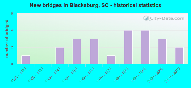
- New bridges - historical statistics
- 11920-1929
- 21940-1949
- 31950-1959
- 31960-1969
- 11970-1979
- 41980-1989
- 41990-1999
- 32000-2009
- 22010-2019


- Bridge Condition - Deck
- 5.3%Excellent
- 15.8%Very good
- 31.6%Good
- 26.3%Satisfactory
- 10.5%Fair
- 10.5%Poor

- Bridge Condition - Superstructure
- 10.5%Excellent
- 21.1%Very good
- 21.1%Good
- 21.1%Satisfactory
- 21.1%Fair
- 5.3%Poor

- Bridge Condition - Substructure
- 5.3%Excellent
- 21.1%Very good
- 15.8%Good
- 15.8%Satisfactory
- 42.1%Fair

- Bridge Condition - Channel
- 28.6%Very good
- 28.6%Good
- 28.6%Satisfactory
- 14.3%Fair

- Bridge Condition - Culverts
- 50.0%Very good
- 50.0%Satisfactory
Find on map >> Show street view
Structure Number: 263, Location: CITY LIMITS BLACKSBURG (Lat: 35.124250, Lng: -81.509275), Route carried "on" structure: US 29, Year Built: 1928, Status: Open, Structure Length: 3.29m (10.79ft), Average Daily Traffic: 5,400 (year 2020), Truck Traffic: 7%, Average Future Daily Traffic: 9,396 (year 2040), Design Load: H 15, Features Intersected: SOUTHERN RAILROAD
Minimum Vertical Clearance: 30+ m (98+ ft), Kilometerpoint: 30.885, Lanes on structure: 2, Base Highway Network: Yes, Owner: State Highway Agency, Approaching Roadway Width: 7.6m (24.9ft), Material/Design: Concrete, Design/Construction: Tee Beam, Number Of Spans In Main Unit: 3, Length of Maximum Span: 11.0m (36.1ft), Curb or Sidewalk Widths: Left: 1.3m (4.3ft), Right: 1.3m (4.3ft), Curb-To-Curb Width: 8.3m (27.2ft), Out-to-Out Width: 11.4m (37.4ft)
Condition: Deck: Poor, Superstructure: Poor, Substructure: Fair, Operating Rating: 36.0 metric tons, Method Used To Determine Operating Rating: Load and Resistance Factor Rating (LRFR) rating reported by rating factor(RF) method using HL-93 loadings, Inventory Rating: 27.5 metric tons, Method Used To Determine Inventory Rating: Load and Resistance Factor Rating (LRFR) rating reported by rating factor(RF) method using HL-93 loadings, Structural Evaluation: Meets minimum limits, Deck Geometry: High priority of replacement, Underclear: Meets minimum limits, Approach Roadway Alignment: Better than present minimum criteria, Length Of Structure Improvement: 4.16m (13.65ft), Designated Inspection Frequency: Every 12 months, Inspection Date: November 2021, Bridge Improvement Cost: $526,000, Roadway Improvement Cost: $132,000, Total Project Cost: $789,000 ( Estimate for 2021), Deck Structure Type: Concrete Cast-file-Place, Wearing Surface/Protective System: Wearing Surface: Bituminous
Find on map >> Show street view
Structure Number: 84, Location: 2.0 MI NW OF BLACKSBURG (Lat: 35.126664, Lng: -81.550258), Route carried "on" structure: State highway 83, Year Built: 2018, Status: Open, Structure Length: 11.89m (39.01ft), Average Daily Traffic: 3,400 (year 2020), Truck Traffic: 7%, Average Future Daily Traffic: 4,964 (year 2040), Design Load: HS 20, Features Intersected: BUFFALO CREEK
Minimum Vertical Clearance: 30+ m (98+ ft), Kilometerpoint: 6.893, Lanes on structure: 2, Owner: State Highway Agency, Approaching Roadway Width: 9.1m (29.9ft), Material/Design: Prestressed concrete, Design/Construction: Stringer/Multi-beam, Number Of Spans In Main Unit: 5, Length of Maximum Span: 26.8m (87.9ft), Curb-To-Curb Width: 13.4m (44.0ft), Out-to-Out Width: 14.4m (47.2ft)
Condition: Deck: Good, Superstructure: Excellent, Substructure: Very good, Channel: Good, Operating Rating: 52.5 metric tons, Method Used To Determine Operating Rating: Load and Resistance Factor Rating (LRFR) rating reported by rating factor(RF) method using HL-93 loadings, Inventory Rating: 40.5 metric tons, Method Used To Determine Inventory Rating: Load and Resistance Factor Rating (LRFR) rating reported by rating factor(RF) method using HL-93 loadings, Structural Evaluation: Equal to present desirable criteria, Deck Geometry: Better than present minimum criteria, Waterway Adequacy: Equal to present desirable criteria, Approach Roadway Alignment: Equal to present desirable criteria, Length Of Structure Improvement: 11.89m (39.01ft), Designated Inspection Frequency: Every 24 months, Inspection Date: November 2020, Deck Structure Type: Concrete Cast-file-Place, Wearing Surface/Protective System: Wearing Surface: Monolithic Concrete
Find on map >> Show street view
Structure Number: 1605, Location: CITY OF BLACKSBURG (Lat: 35.126617, Lng: -81.512239), Route carried "on" structure: State highway 127, Year Built: 1949, Status: Open, Structure Length: 3.66m (12.01ft), Average Daily Traffic: 1,550 (year 2020), Truck Traffic: 3%, Average Future Daily Traffic: 1,984 (year 2040), Design Load: HS 20, Features Intersected: SOUTHERN RAILROAD
Minimum Vertical Clearance: 30+ m (98+ ft), Kilometerpoint: 0.341, Lanes on structure: 2, Owner: State Highway Agency, Approaching Roadway Width: 8.5m (27.9ft), Material/Design: Concrete, Design/Construction: Tee Beam, Number Of Spans In Main Unit: 3, Length of Maximum Span: 12.2m (40.0ft), Curb or Sidewalk Widths: Left: 1.5m (4.9ft), Right: 1.5m (4.9ft), Curb-To-Curb Width: 12.2m (40.0ft), Out-to-Out Width: 16.9m (55.4ft)
Condition: Deck: Satisfactory, Superstructure: Fair, Substructure: Satisfactory, Operating Rating: 19.8 metric tons, Method Used To Determine Operating Rating: Load and Resistance Factor Rating (LRFR) rating reported by rating factor(RF) method using HL-93 loadings, Inventory Rating: 15.2 metric tons, Method Used To Determine Inventory Rating: Load and Resistance Factor Rating (LRFR) rating reported by rating factor(RF) method using HL-93 loadings, Structural Evaluation: Meets minimum limits, Deck Geometry: Better than present minimum criteria, Underclear: Equal to present minimum criteria, Approach Roadway Alignment: Equal to present desirable criteria, Bridge Posting: Required (Relationship of Operating Rating to Maximum Legal Load: > 39.9% below), Length Of Structure Improvement: 4.54m (14.90ft), Designated Inspection Frequency: Every 12 months, Inspection Date: January 2021, Bridge Improvement Cost: $458,000, Roadway Improvement Cost: $115,000, Total Project Cost: $687,000 ( Estimate for 2021), Deck Structure Type: Concrete Cast-file-Place, Wearing Surface/Protective System: Wearing Surface: Bituminous
Find on map >> Show street view
Structure Number: 1606, Location: 2.6 MI N OF BLACKSBURG (Lat: 35.157322, Lng: -81.517408), Route carried "on" structure: State highway 198, Year Built: 1949, Year Reconstructed: 1975, Status: Open, Structure Length: 0.98m (3.22ft), Average Daily Traffic: 2,000 (year 2020), Truck Traffic: 10%, Average Future Daily Traffic: 2,920 (year 2040), Design Load: H 20, Features Intersected: SAPOCH CREEK
Minimum Vertical Clearance: 30+ m (98+ ft), Kilometerpoint: 2.552, Lanes on structure: 2, Owner: State Highway Agency, Approaching Roadway Width: 9.8m (32.2ft), Material/Design: Concrete, Design/Construction: Culvert, Number Of Spans In Main Unit: 3, Length of Maximum Span: 3.0m (9.8ft), Curb-To-Curb Width: 9.8m (32.2ft), Out-to-Out Width: 16.3m (53.5ft)
Condition: Channel: Fair, Culverts: Satisfactory, Operating Rating: 23.3 metric tons, Method Used To Determine Operating Rating: Load and Resistance Factor Rating (LRFR) rating reported by rating factor(RF) method using HL-93 loadings, Inventory Rating: 18.1 metric tons, Method Used To Determine Inventory Rating: Load and Resistance Factor Rating (LRFR) rating reported by rating factor(RF) method using HL-93 loadings, Structural Evaluation: Somewhat better than minimum adequacy, Deck Geometry: Somewhat better than minimum adequacy, Waterway Adequacy: Better than present minimum criteria, Approach Roadway Alignment: Equal to present desirable criteria, Length Of Structure Improvement: 0.98m (3.22ft), Designated Inspection Frequency: Every 24 months, Inspection Date: January 2020
Find on map >> Show street view
Structure Number: 2485, Location: 7.5 MI NE OF GAFFNEY (Lat: 35.130367, Lng: -81.545269), Route carried "on" structure: Interstate 85, Year Built: 2004, Status: Open, Structure Length: 11.34m (37.20ft), Average Daily Traffic: 47,700 (year 2020), Truck Traffic: 19%, Average Future Daily Traffic: 83,475 (year 2040), Design Load: HS 25 or greater, Features Intersected: BUFFALO CREEK
Minimum Vertical Clearance: 30+ m (98+ ft), Kilometerpoint: 160.487, Lanes on structure: 4, Base Highway Network: Yes, Owner: State Highway Agency, Approaching Roadway Width: 16.2m (53.1ft), Skew: 30 degrees, Material/Design: Steel continuous, Design/Construction: Stringer/Multi-beam, Number Of Spans In Main Unit: 1, Number Of Approach Spans: 2, Length of Maximum Span: 43.9m (144.0ft), Curb-To-Curb Width: 33.8m (110.9ft), Out-to-Out Width: 35.7m (117.1ft)
Condition: Deck: Very good, Superstructure: Very good, Substructure: Very good, Channel: Very good, Operating Rating: 48.3 metric tons, Method Used To Determine Operating Rating: Load and Resistance Factor Rating (LRFR) rating reported by rating factor(RF) method using HL-93 loadings, Inventory Rating: 41.8 metric tons, Method Used To Determine Inventory Rating: Load and Resistance Factor Rating (LRFR) rating reported by rating factor(RF) method using HL-93 loadings, Structural Evaluation: Equal to present desirable criteria, Deck Geometry: Superior to present desirable criteria, Waterway Adequacy: Equal to present desirable criteria, Approach Roadway Alignment: Equal to present desirable criteria, Length Of Structure Improvement: 11.34m (37.20ft), Designated Inspection Frequency: Every 24 months, Inspection Date: January 2020, Deck Structure Type: Concrete Cast-file-Place, Wearing Surface/Protective System: Wearing Surface: Bituminous
Find on map >> Show street view
Structure Number: 2674, Location: 2.1 MI NW OF BLACKSBURG (Lat: 35.128736, Lng: -81.551533), Route carried "on" structure: State highway 83, Year Built: 1958, Status: Posted for load, Structure Length: 6.40m (21.00ft), Average Daily Traffic: 2,800 (year 2020), Truck Traffic: 9%, Average Future Daily Traffic: 4,088 (year 2040), Design Load: HS 20, Features Intersected: I-85
Minimum Vertical Clearance: 5.00m (16.40ft), Kilometerpoint: 6.669, Lanes on structure: 2, Lanes under structure: 4, Owner: State Highway Agency, Approaching Roadway Width: 9.1m (29.9ft), Material/Design: Concrete, Design/Construction: Tee Beam, Number Of Spans In Main Unit: 4, Length of Maximum Span: 16.8m (55.1ft), Curb or Sidewalk Widths: Left: 0.5m (1.6ft), Right: 0.5m (1.6ft), Curb-To-Curb Width: 8.6m (28.2ft), Out-to-Out Width: 10.2m (33.5ft)
Condition: Deck: Satisfactory, Superstructure: Satisfactory, Substructure: Satisfactory, Operating Rating: 59.3 metric tons, Method Used To Determine Operating Rating: Load and Resistance Factor Rating (LRFR) rating reported by rating factor(RF) method using HL-93 loadings, Inventory Rating: 45.7 metric tons, Method Used To Determine Inventory Rating: Load and Resistance Factor Rating (LRFR) rating reported by rating factor(RF) method using HL-93 loadings, Structural Evaluation: Equal to present minimum criteria, Deck Geometry: Meets minimum limits, Underclear: High priority of replacement, Approach Roadway Alignment: Equal to present desirable criteria, Bridge Posting: Required (Relationship of Operating Rating to Maximum Legal Load: > 39.9% below), Length Of Structure Improvement: 7.39m (24.25ft), Designated Inspection Frequency: Every 24 months, Inspection Date: November 2020, Bridge Improvement Cost: $746,000, Roadway Improvement Cost: $187,000, Total Project Cost: $1,119,000 ( Estimate for 2021), Deck Structure Type: Concrete Cast-file-Place, Wearing Surface/Protective System: Wearing Surface: Monolithic Concrete
Find on map >> Show street view
Structure Number: 2675, Location: 1.9 MI SE OF BLACKSBURG (Lat: 35.113475, Lng: -81.483903), Route carried "on" structure: State highway 5, Year Built: 2007, Status: Open, Structure Length: 3.90m (12.80ft), Average Daily Traffic: 8,100 (year 2020), Truck Traffic: 14%, Average Future Daily Traffic: 14,094 (year 2040), Design Load: HS 20, Features Intersected: SOUTHERN RAILROAD
Minimum Vertical Clearance: 30+ m (98+ ft), Kilometerpoint: 4.352, Lanes on structure: 4, Base Highway Network: Yes, Owner: State Highway Agency, Approaching Roadway Width: 23.8m (78.1ft), Skew: 4 degrees, Material/Design: Prestressed concrete, Design/Construction: Stringer/Multi-beam, Number Of Spans In Main Unit: 1, Length of Maximum Span: 39.0m (128.0ft), Curb or Sidewalk Widths: Left: 1.5m (4.9ft), Right: 1.5m (4.9ft), Curb-To-Curb Width: 23.8m (78.1ft), Out-to-Out Width: 27.7m (90.9ft)
Condition: Deck: Good, Superstructure: Very good, Substructure: Very good, Operating Rating: 80.4 metric tons, Method Used To Determine Operating Rating: Load and Resistance Factor Rating (LRFR) rating reported by rating factor(RF) method using HL-93 loadings, Inventory Rating: 39.9 metric tons, Method Used To Determine Inventory Rating: Load and Resistance Factor Rating (LRFR) rating reported by rating factor(RF) method using HL-93 loadings, Structural Evaluation: Equal to present desirable criteria, Deck Geometry: Superior to present desirable criteria, Underclear: Somewhat better than minimum adequacy, Approach Roadway Alignment: Equal to present desirable criteria, Length Of Structure Improvement: 3.90m (12.80ft), Designated Inspection Frequency: Every 24 months, Inspection Date: January 2020, Deck Structure Type: Concrete Cast-file-Place, Wearing Surface/Protective System: Wearing Surface: Monolithic Concrete
Find on map >> Show street view
Structure Number: 3833, Location: 2.0MI W BLACKSBURG (Lat: 35.115258, Lng: -81.539275), Route carried "on" structure: State highway 245, Year Built: 1962, Status: Posted for load, Structure Length: 1.83m (6.00ft), Average Daily Traffic: 1,000 (year 2020), Truck Traffic: 8%, Average Future Daily Traffic: 1,460 (year 2040), Design Load: H 10, Features Intersected: BR OF DOOLITTLE CK
Minimum Vertical Clearance: 30+ m (98+ ft), Kilometerpoint: 3.037, Lanes on structure: 2, Owner: State Highway Agency, Approaching Roadway Width: 9.1m (29.9ft), Material/Design: Concrete, Design/Construction: Slab, Number Of Spans In Main Unit: 4, Length of Maximum Span: 4.6m (15.1ft), Curb or Sidewalk Widths: Left: 0.2m (0.7ft), Right: 0.2m (0.7ft), Curb-To-Curb Width: 7.9m (25.9ft), Out-to-Out Width: 8.4m (27.6ft)
Condition: Deck: Fair, Superstructure: Fair, Substructure: Fair, Channel: Satisfactory, Operating Rating: 15.2 metric tons, Method Used To Determine Operating Rating: Load and Resistance Factor Rating (LRFR) rating reported by rating factor(RF) method using HL-93 loadings, Inventory Rating: 11.7 metric tons, Method Used To Determine Inventory Rating: Load and Resistance Factor Rating (LRFR) rating reported by rating factor(RF) method using HL-93 loadings, Structural Evaluation: High priority of replacement, Deck Geometry: Somewhat better than minimum adequacy, Waterway Adequacy: Better than present minimum criteria, Approach Roadway Alignment: Equal to present desirable criteria, Bridge Posting: Required (Relationship of Operating Rating to Maximum Legal Load: > 39.9% below), Length Of Structure Improvement: 2.56m (8.40ft), Designated Inspection Frequency: Every 24 months, Inspection Date: October 2021, Bridge Improvement Cost: $258,000, Roadway Improvement Cost: $65,000, Total Project Cost: $387,000 ( Estimate for 2021), Deck Structure Type: Concrete Precast Panels, Wearing Surface/Protective System: Wearing Surface: Bituminous
Find on map >> Show street view
Structure Number: 4281, Location: 2.4MI S BLACKSBURG (Lat: 35.089664, Lng: -81.531317), Route carried "on" structure: State highway 320, Year Built: 1964, Status: Open, Structure Length: 2.74m (8.99ft), Average Daily Traffic: 325 (year 2020), Truck Traffic: 5%, Average Future Daily Traffic: 416 (year 2040), Design Load: H 10, Features Intersected: DOOLITTLE CREEK
Minimum Vertical Clearance: 30+ m (98+ ft), Kilometerpoint: 2.588, Lanes on structure: 2, Owner: State Highway Agency, Approaching Roadway Width: 8.5m (27.9ft), Material/Design: Prestressed concrete, Design/Construction: Stringer/Multi-beam, Number Of Spans In Main Unit: 1, Number Of Approach Spans: 4, Length of Maximum Span: 9.1m (29.9ft), Curb-To-Curb Width: 8.0m (26.2ft), Out-to-Out Width: 8.4m (27.6ft)
Condition: Deck: Poor, Superstructure: Fair, Substructure: Fair, Channel: Satisfactory, Operating Rating: 17.2 metric tons, Method Used To Determine Operating Rating: Load and Resistance Factor Rating (LRFR) rating reported by rating factor(RF) method using HL-93 loadings, Inventory Rating: 10.4 metric tons, Method Used To Determine Inventory Rating: Load and Resistance Factor Rating (LRFR) rating reported by rating factor(RF) method using HL-93 loadings, Structural Evaluation: High priority of replacement, Deck Geometry: Somewhat better than minimum adequacy, Waterway Adequacy: Better than present minimum criteria, Approach Roadway Alignment: Equal to present desirable criteria, Bridge Posting: Required (Relationship of Operating Rating to Maximum Legal Load: > 39.9% below), Length Of Structure Improvement: 3.57m (11.71ft), Designated Inspection Frequency: Every 12 months, Inspection Date: October 2021, Bridge Improvement Cost: $345,000, Roadway Improvement Cost: $86,000, Total Project Cost: $518,000 ( Estimate for 2021), Deck Structure Type: Concrete Precast Panels, Wearing Surface/Protective System: Wearing Surface: Bituminous
Find on map >> Show street view
Structure Number: 4957, Location: 3.5MI SE BLACKSBURG (Lat: 35.078453, Lng: -81.480778), Route carried "on" structure: State highway 100, Year Built: 1967, Status: Open, Structure Length: 2.29m (7.51ft), Average Daily Traffic: 350 (year 2021), Truck Traffic: 5%, Average Future Daily Traffic: 448 (year 2041), Design Load: H 10, Features Intersected: BELLS BRANCH
Minimum Vertical Clearance: 30+ m (98+ ft), Kilometerpoint: 6.259, Lanes on structure: 2, Owner: State Highway Agency, Approaching Roadway Width: 9.4m (30.8ft), Material/Design: Concrete, Design/Construction: Slab, Number Of Spans In Main Unit: 5, Length of Maximum Span: 4.6m (15.1ft), Curb-To-Curb Width: 7.9m (25.9ft), Out-to-Out Width: 8.4m (27.6ft)
Condition: Deck: Fair, Superstructure: Fair, Substructure: Fair, Channel: Good, Operating Rating: 17.2 metric tons, Method Used To Determine Operating Rating: Load and Resistance Factor Rating (LRFR) rating reported by rating factor(RF) method using HL-93 loadings, Inventory Rating: 13.3 metric tons, Method Used To Determine Inventory Rating: Load and Resistance Factor Rating (LRFR) rating reported by rating factor(RF) method using HL-93 loadings, Structural Evaluation: Meets minimum limits, Deck Geometry: Somewhat better than minimum adequacy, Waterway Adequacy: Better than present minimum criteria, Approach Roadway Alignment: Better than present minimum criteria, Bridge Posting: Required (Relationship of Operating Rating to Maximum Legal Load: > 39.9% below), Length Of Structure Improvement: 2.29m (7.51ft), Designated Inspection Frequency: Every 24 months, Inspection Date: October 2021, Deck Structure Type: Concrete Precast Panels, Wearing Surface/Protective System: Wearing Surface: Bituminous
Find on map >> Show street view
Structure Number: 7657, Location: 3.5MI SE BLACKSBURG (Lat: 35.096878, Lng: -81.461514), Route carried "on" structure: State highway 68, Year Built: 1983, Status: Open, Structure Length: 2.80m (9.19ft), Average Daily Traffic: 350 (year 2020), Truck Traffic: 5%, Average Future Daily Traffic: 448 (year 2040), Design Load: HS 15, Features Intersected: SOU RR
Minimum Vertical Clearance: 30+ m (98+ ft), Kilometerpoint: 3.362, Lanes on structure: 2, Owner: State Highway Agency, Approaching Roadway Width: 9.8m (32.2ft), Skew: 3 degrees, Material/Design: Steel continuous, Design/Construction: Stringer/Multi-beam, Number Of Spans In Main Unit: 1, Length of Maximum Span: 28.0m (91.9ft), Curb-To-Curb Width: 9.8m (32.2ft), Out-to-Out Width: 10.9m (35.8ft)
Condition: Deck: Good, Superstructure: Good, Substructure: Good, Operating Rating: 69.3 metric tons, Method Used To Determine Operating Rating: Load and Resistance Factor Rating (LRFR) rating reported by rating factor(RF) method using HL-93 loadings, Inventory Rating: 53.5 metric tons, Method Used To Determine Inventory Rating: Load and Resistance Factor Rating (LRFR) rating reported by rating factor(RF) method using HL-93 loadings, Structural Evaluation: Better than present minimum criteria, Deck Geometry: Better than present minimum criteria, Underclear: Somewhat better than minimum adequacy, Approach Roadway Alignment: Equal to present desirable criteria, Length Of Structure Improvement: 2.80m (9.19ft), Designated Inspection Frequency: Every 24 months, Inspection Date: January 2021, Deck Structure Type: Concrete Cast-file-Place, Wearing Surface/Protective System: Wearing Surface: Monolithic Concrete
Find on map >> Show street view
Structure Number: 7983, Location: 1.2MI SE BLACKSBURG (Lat: 35.106492, Lng: -81.506128), Route carried "on" structure: State highway 100, Year Built: 1986, Status: Open, Structure Length: 0.79m (2.59ft), Average Daily Traffic: 325 (year 2020), Truck Traffic: 5%, Average Future Daily Traffic: 416 (year 2040), Design Load: HS 20, Features Intersected: DOOLITTLE CREEK
Minimum Vertical Clearance: 30+ m (98+ ft), Kilometerpoint: 2.031, Lanes on structure: 2, Owner: State Highway Agency, Approaching Roadway Width: 9.1m (29.9ft), Material/Design: Concrete, Design/Construction: Culvert, Number Of Spans In Main Unit: 2, Length of Maximum Span: 3.7m (12.1ft), Curb-To-Curb Width: 13.4m (44.0ft), Out-to-Out Width: 35.7m (117.1ft)
Condition: Channel: Very good, Culverts: Very good, Operating Rating: 97.2 metric tons, Method Used To Determine Operating Rating: Load and Resistance Factor Rating (LRFR) rating reported by rating factor(RF) method using HL-93 loadings, Inventory Rating: 91.7 metric tons, Method Used To Determine Inventory Rating: Load and Resistance Factor Rating (LRFR) rating reported by rating factor(RF) method using HL-93 loadings, Structural Evaluation: Equal to present desirable criteria, Deck Geometry: Superior to present desirable criteria, Waterway Adequacy: Equal to present desirable criteria, Approach Roadway Alignment: Equal to present desirable criteria, Length Of Structure Improvement: 0.79m (2.59ft), Designated Inspection Frequency: Every 24 months, Inspection Date: November 2020
Find on map >> Show street view
Structure Number: 8143, Location: 3.5MI SE BLACKSBURG (Lat: 35.085950, Lng: -81.478669), Route carried "on" structure: State highway 68, Year Built: 1988, Status: Posted for load, Structure Length: 2.74m (8.99ft), Average Daily Traffic: 350 (year 2020), Truck Traffic: 5%, Average Future Daily Traffic: 448 (year 2040), Design Load: HS 20, Features Intersected: BELLS BRANCH
Minimum Vertical Clearance: 30+ m (98+ ft), Kilometerpoint: 5.428, Lanes on structure: 2, Owner: State Highway Agency, Approaching Roadway Width: 11.3m (37.1ft), Material/Design: Prestressed concrete, Design/Construction: Box Beam or Girders - Multiple, Number Of Spans In Main Unit: 1, Number Of Approach Spans: 4, Length of Maximum Span: 9.1m (29.9ft), Curb-To-Curb Width: 10.4m (34.1ft), Out-to-Out Width: 11.6m (38.1ft)
Condition: Deck: Satisfactory, Superstructure: Satisfactory, Substructure: Fair, Channel: Satisfactory, Operating Rating: 30.5 metric tons, Method Used To Determine Operating Rating: Load and Resistance Factor Rating (LRFR) rating reported by rating factor(RF) method using HL-93 loadings, Inventory Rating: 12.0 metric tons, Method Used To Determine Inventory Rating: Load and Resistance Factor Rating (LRFR) rating reported by rating factor(RF) method using HL-93 loadings, Structural Evaluation: Meets minimum limits, Deck Geometry: Better than present minimum criteria, Waterway Adequacy: Better than present minimum criteria, Approach Roadway Alignment: Better than present minimum criteria, Bridge Posting: Required (Relationship of Operating Rating to Maximum Legal Load: 0.1 - 9.9% below), Length Of Structure Improvement: 2.74m (8.99ft), Designated Inspection Frequency: Every 24 months, Other Special Inspection Frequency: Every 24 months, Inspection Date: December 2020, Other Special Inspection Date: May 2021, Deck Structure Type: Concrete Precast Panels, Wearing Surface/Protective System: Wearing Surface: Bituminous
Find on map >> Show street view
Structure Number: 824, Location: 2.4MI NW BLACKSBURG (Lat: 35.151753, Lng: -81.534356), Route carried "on" structure: State highway 213, Year Built: 1989, Status: Open, Structure Length: 8.99m (29.49ft), Average Daily Traffic: 325 (year 2020), Truck Traffic: 5%, Average Future Daily Traffic: 416 (year 2040), Design Load: HS 20, Features Intersected: BUFFALO CREEK
Minimum Vertical Clearance: 30+ m (98+ ft), Kilometerpoint: 2.013, Lanes on structure: 2, Owner: State Highway Agency, Approaching Roadway Width: 10.7m (35.1ft), Material/Design: Steel, Design/Construction: Stringer/Multi-beam, Number Of Spans In Main Unit: 1, Number Of Approach Spans: 6, Length of Maximum Span: 35.1m (115.2ft), Curb-To-Curb Width: 10.5m (34.4ft), Out-to-Out Width: 11.3m (37.1ft)
Condition: Deck: Good, Superstructure: Good, Substructure: Good, Channel: Very good, Operating Rating: 34.3 metric tons, Method Used To Determine Operating Rating: Load and Resistance Factor Rating (LRFR) rating reported by rating factor(RF) method using HL-93 loadings, Inventory Rating: 26.2 metric tons, Method Used To Determine Inventory Rating: Load and Resistance Factor Rating (LRFR) rating reported by rating factor(RF) method using HL-93 loadings, Structural Evaluation: Equal to present minimum criteria, Deck Geometry: Better than present minimum criteria, Waterway Adequacy: Equal to present desirable criteria, Approach Roadway Alignment: Equal to present desirable criteria, Length Of Structure Improvement: 8.99m (29.49ft), Designated Inspection Frequency: Every 24 months, Inspection Date: December 2020, Deck Structure Type: Concrete Cast-file-Place, Wearing Surface/Protective System: Wearing Surface: Monolithic Concrete
Find on map >> Show street view
Structure Number: 8333, Location: 2.8MI N BLACKSBURG (Lat: 35.161269, Lng: -81.505028), Route carried "on" structure: State highway 52, Year Built: 1990, Status: Open, Structure Length: 1.37m (4.49ft), Average Daily Traffic: 325 (year 2020), Truck Traffic: 5%, Average Future Daily Traffic: 416 (year 2040), Design Load: H 15, Features Intersected: BUFFALO CREEK
Minimum Vertical Clearance: 30+ m (98+ ft), Kilometerpoint: 1.973, Lanes on structure: 2, Owner: State Highway Agency, Approaching Roadway Width: 8.5m (27.9ft), Material/Design: Prestressed concrete, Design/Construction: Stringer/Multi-beam, Number Of Spans In Main Unit: 1, Number Of Approach Spans: 1, Length of Maximum Span: 9.1m (29.9ft), Curb-To-Curb Width: 9.6m (31.5ft), Out-to-Out Width: 10.5m (34.4ft)
Condition: Deck: Satisfactory, Superstructure: Satisfactory, Substructure: Fair, Channel: Satisfactory, Operating Rating: 46.3 metric tons, Method Used To Determine Operating Rating: Load and Resistance Factor Rating (LRFR) rating reported by rating factor(RF) method using HL-93 loadings, Inventory Rating: 35.6 metric tons, Method Used To Determine Inventory Rating: Load and Resistance Factor Rating (LRFR) rating reported by rating factor(RF) method using HL-93 loadings, Structural Evaluation: Somewhat better than minimum adequacy, Deck Geometry: Equal to present minimum criteria, Waterway Adequacy: Better than present minimum criteria, Approach Roadway Alignment: Equal to present minimum criteria, Length Of Structure Improvement: 1.37m (4.49ft), Designated Inspection Frequency: Every 24 months, Inspection Date: December 2021, Deck Structure Type: Concrete Precast Panels, Wearing Surface/Protective System: Wearing Surface: Bituminous
Find on map >> Show street view
Structure Number: 8966, Location: 3.5 MI E OF DENMARK (Lat: 33.359903, Lng: -81.103975), Route carried "on" structure: State highway 70, Year Built: 1996, Status: Open, Structure Length: 1.83m (6.00ft), Average Daily Traffic: 2,400 (year 2020), Truck Traffic: 6%, Average Future Daily Traffic: 3,816 (year 2040), Design Load: HS 20, Features Intersected: HAYES MILL CREEK
Minimum Vertical Clearance: 30+ m (98+ ft), Kilometerpoint: 13.987, Lanes on structure: 2, Base Highway Network: Yes, Owner: State Highway Agency, Approaching Roadway Width: 7.3m (24.0ft), Material/Design: Prestressed concrete, Design/Construction: Slab, Number Of Spans In Main Unit: 1, Number Of Approach Spans: 2, Length of Maximum Span: 9.1m (29.9ft), Curb-To-Curb Width: 10.4m (34.1ft), Out-to-Out Width: 11.8m (38.7ft)
Condition: Deck: Good, Superstructure: Good, Substructure: Fair, Channel: Good, Operating Rating: 26.2 metric tons, Method Used To Determine Operating Rating: Load and Resistance Factor Rating (LRFR) rating reported by rating factor(RF) method using HL-93 loadings, Inventory Rating: 20.1 metric tons, Method Used To Determine Inventory Rating: Load and Resistance Factor Rating (LRFR) rating reported by rating factor(RF) method using HL-93 loadings, Structural Evaluation: Somewhat better than minimum adequacy, Deck Geometry: Somewhat better than minimum adequacy, Waterway Adequacy: Better than present minimum criteria, Approach Roadway Alignment: Equal to present desirable criteria, Length Of Structure Improvement: 1.83m (6.00ft), Designated Inspection Frequency: Every 24 months, Inspection Date: April 2020, Deck Structure Type: Concrete Precast Panels, Wearing Surface/Protective System: Wearing Surface: Bituminous
Find on map >> Show street view
Structure Number: 8991, Location: 3MI SE MANNING (Lat: 33.659136, Lng: -80.179431), Route carried "on" structure: State highway 262, Year Built: 1996, Status: Open, Structure Length: 1.22m (4.00ft), Average Daily Traffic: 500 (year 2020), Truck Traffic: 3%, Average Future Daily Traffic: 640 (year 2040), Design Load: HS 20, Features Intersected: BEAR CREEK
Minimum Vertical Clearance: 30+ m (98+ ft), Kilometerpoint: 0.958, Lanes on structure: 2, Owner: State Highway Agency, Approaching Roadway Width: 7.0m (23.0ft), Material/Design: Prestressed concrete, Design/Construction: Slab, Number Of Spans In Main Unit: 1, Length of Maximum Span: 12.2m (40.0ft), Curb-To-Curb Width: 10.4m (34.1ft), Out-to-Out Width: 11.7m (38.4ft)
Condition: Deck: Very good, Superstructure: Very good, Substructure: Good, Channel: Very good, Operating Rating: 19.8 metric tons, Method Used To Determine Operating Rating: Load and Resistance Factor Rating (LRFR) rating reported by rating factor(RF) method using HL-93 loadings, Inventory Rating: 13.9 metric tons, Method Used To Determine Inventory Rating: Load and Resistance Factor Rating (LRFR) rating reported by rating factor(RF) method using HL-93 loadings, Structural Evaluation: Meets minimum limits, Deck Geometry: Equal to present minimum criteria, Waterway Adequacy: Better than present minimum criteria, Approach Roadway Alignment: Equal to present desirable criteria, Length Of Structure Improvement: 1.22m (4.00ft), Designated Inspection Frequency: Every 24 months, Inspection Date: October 2020, Deck Structure Type: Concrete Precast Panels, Wearing Surface/Protective System: Wearing Surface: Bituminous
Find on map >> Show street view
Structure Number: 9752, Location: IN BLACKSBURG (Lat: 35.120006, Lng: -81.509806), Route carried "on" structure: State highway 612, Year Built: 1975, Status: Open, Structure Length: 1.37m (4.49ft), Average Daily Traffic: 475 (year 2021), Truck Traffic: 5%, Average Future Daily Traffic: 608 (year 2041), Design Load: H 10, Features Intersected: STREAM
Minimum Vertical Clearance: 30+ m (98+ ft), Kilometerpoint: 0.311, Lanes on structure: 2, Owner: State Highway Agency, Approaching Roadway Width: 7.9m (25.9ft), Material/Design: Concrete, Design/Construction: Slab, Number Of Spans In Main Unit: 3, Length of Maximum Span: 4.6m (15.1ft), Curb-To-Curb Width: 7.9m (25.9ft), Out-to-Out Width: 8.4m (27.6ft)
Condition: Deck: Satisfactory, Superstructure: Satisfactory, Substructure: Fair, Channel: Fair, Operating Rating: 14.3 metric tons, Method Used To Determine Operating Rating: Load and Resistance Factor Rating (LRFR) rating reported by rating factor(RF) method using HL-93 loadings, Inventory Rating: 11.0 metric tons, Method Used To Determine Inventory Rating: Load and Resistance Factor Rating (LRFR) rating reported by rating factor(RF) method using HL-93 loadings, Structural Evaluation: Meets minimum limits, Deck Geometry: Somewhat better than minimum adequacy, Waterway Adequacy: Meets minimum limits, Approach Roadway Alignment: Equal to present minimum criteria, Bridge Posting: Required (Relationship of Operating Rating to Maximum Legal Load: > 39.9% below), Length Of Structure Improvement: 1.37m (4.49ft), Designated Inspection Frequency: Every 24 months, Inspection Date: October 2021, Deck Structure Type: Concrete Precast Panels, Wearing Surface/Protective System: Wearing Surface: Bituminous
Find on map >> Show street view
Structure Number: 9754, Location: 1 MI E BLACKSBURG (Lat: 35.128008, Lng: -81.504353), Route carried "on" structure: State highway 5, Year Built: 2003, Status: Open, Structure Length: 4.11m (13.48ft), Average Daily Traffic: 8,900 (year 2020), Truck Traffic: 14%, Average Future Daily Traffic: 15,486 (year 2040), Design Load: HS 20, Features Intersected: SOUTHERN RR
Minimum Vertical Clearance: 30+ m (98+ ft), Kilometerpoint: 1.642, Lanes on structure: 4, Base Highway Network: Yes, Owner: State Highway Agency, Approaching Roadway Width: 20.1m (65.9ft), Skew: 2 degrees, Material/Design: Prestressed concrete continuous, Design/Construction: Stringer/Multi-beam, Number Of Spans In Main Unit: 1, Length of Maximum Span: 41.1m (134.8ft), Curb-To-Curb Width: 20.1m (65.9ft), Out-to-Out Width: 23.8m (78.1ft)
Condition: Deck: Very good, Superstructure: Very good, Substructure: Very good, Operating Rating: 63.8 metric tons, Method Used To Determine Operating Rating: Load and Resistance Factor Rating (LRFR) rating reported by rating factor(RF) method using HL-93 loadings, Inventory Rating: 35.0 metric tons, Method Used To Determine Inventory Rating: Load and Resistance Factor Rating (LRFR) rating reported by rating factor(RF) method using HL-93 loadings, Structural Evaluation: Equal to present desirable criteria, Deck Geometry: Better than present minimum criteria, Underclear: Superior to present desirable criteria, Approach Roadway Alignment: Equal to present desirable criteria, Length Of Structure Improvement: 4.11m (13.48ft), Designated Inspection Frequency: Every 24 months, Inspection Date: January 2020, Deck Structure Type: Concrete Cast-file-Place, Wearing Surface/Protective System: Wearing Surface: Monolithic Concrete
Find on map >> Show street view
Structure Number: 9873, Location: TOWN OF BLACKSBURG (Lat: 35.126156, Lng: -81.514125), Route carried "on" structure: County highway 1032, Year Built: 1999, Status: Open, Structure Length: 3.66m (12.01ft), Average Daily Traffic: 200 (year 2020), Truck Traffic: 5%, Average Future Daily Traffic: 256 (year 2040), Design Load: HS 20, Features Intersected: SOUTHERN R.R
Minimum Vertical Clearance: 30+ m (98+ ft), Kilometerpoint: 0.111, Lanes on structure: 2, Owner: County Highway Agency, Approaching Roadway Width: 7.0m (23.0ft), Material/Design: Prestressed concrete, Design/Construction: Slab, Number Of Spans In Main Unit: 3, Length of Maximum Span: 12.2m (40.0ft), Curb-To-Curb Width: 8.5m (27.9ft), Out-to-Out Width: 9.8m (32.2ft)
Condition: Deck: Good, Superstructure: Good, Substructure: Satisfactory, Operating Rating: 63.5 metric tons, Method Used To Determine Operating Rating: Load and Resistance Factor Rating (LRFR) rating reported by rating factor(RF) method using HL-93 loadings, Inventory Rating: 49.2 metric tons, Method Used To Determine Inventory Rating: Load and Resistance Factor Rating (LRFR) rating reported by rating factor(RF) method using HL-93 loadings, Structural Evaluation: Equal to present minimum criteria, Deck Geometry: High priority of corrective action, Underclear: High priority of corrective action, Approach Roadway Alignment: Better than present minimum criteria, Length Of Structure Improvement: 3.66m (12.01ft), Designated Inspection Frequency: Every 24 months, Inspection Date: January 2020, Deck Structure Type: Concrete Precast Panels, Wearing Surface/Protective System: Wearing Surface: Bituminous
Find on map >> Show street view
Structure Number: 10027, Location: 5 W OF BLACKSBURG (Lat: 35.118586, Lng: -81.462331), Route carried "on" structure: State highway 66, Year Built: 2014, Status: Open, Structure Length: 2.13m (6.99ft), Average Daily Traffic: 400 (year 2020), Truck Traffic: 6%, Average Future Daily Traffic: 584 (year 2040), Design Load: HS 20, Features Intersected: STREAM
Minimum Vertical Clearance: 30+ m (98+ ft), Kilometerpoint: 2.942, Lanes on structure: 2, Owner: State Highway Agency, Approaching Roadway Width: 10.7m (35.1ft), Material/Design: Prestressed concrete, Design/Construction: Slab, Number Of Spans In Main Unit: 1, Length of Maximum Span: 21.3m (69.9ft), Curb-To-Curb Width: 9.8m (32.2ft), Out-to-Out Width: 10.7m (35.1ft)
Condition: Deck: Excellent, Superstructure: Excellent, Substructure: Excellent, Channel: Good, Operating Rating: 69.7 metric tons, Method Used To Determine Operating Rating: Load and Resistance Factor Rating (LRFR) rating reported by rating factor(RF) method using HL-93 loadings, Inventory Rating: 42.8 metric tons, Method Used To Determine Inventory Rating: Load and Resistance Factor Rating (LRFR) rating reported by rating factor(RF) method using HL-93 loadings, Structural Evaluation: Superior to present desirable criteria, Deck Geometry: Meets minimum limits, Waterway Adequacy: Equal to present desirable criteria, Approach Roadway Alignment: Equal to present minimum criteria, Length Of Structure Improvement: 2.13m (6.99ft), Designated Inspection Frequency: Every 24 months, Inspection Date: June 2020, Deck Structure Type: Concrete Precast Panels, Wearing Surface/Protective System: Wearing Surface: Monolithic Concrete
Find on map >> Show street view
Structure Number: 2674, Location: 2.1 MI NW OF BLACKSBURG (Lat: 35.128736, Lng: -81.551533), Route carried "under" structure: Interstate 85, Year Built: 1958, Structure Length: 0. m, Average Daily Traffic: 49,000 (year 2020), Truck Traffic: 25%, Features Intersected: I-85, Facility Carried by Structure: S-83
Minimum Vertical Clearance: 4.78m (15.68ft), Kilometerpoint: 159.969, Lanes on structure: 2, Lanes under structure: 4, Material/Design: Concrete, Design/Construction: Tee Beam, Length of Maximum Span: 16.8m (55.1ft)
Find on map >> Show street view
Structure Number: 2682, Location: 1.0 MI N OF BLACKSBURG (Lat: 35.140983, Lng: -81.508472), Route carried "under" structure: Interstate 85, Year Built: 1958, Structure Length: 0. m, Average Daily Traffic: 47,700 (year 2020), Truck Traffic: 19%, Features Intersected: I-85, Facility Carried by Structure: SC 198
Minimum Vertical Clearance: 5.49m (18.01ft), Kilometerpoint: 164.137, Lanes on structure: 2, Lanes under structure: 4, Material/Design: Prestressed concrete, Design/Construction: Stringer/Multi-beam, Length of Maximum Span: 23.2m (76.1ft)