Bridge Statistics for Blackwood, New Jersey (NJ)
Condition, Traffic, Stress, Structural Evaluation, Project Costs
- National Bridge Inventory (NBI) Statistics
- 23Number of bridges
- 161ft / 48.6mTotal length
- $2,798,000Total costs
- 991,025Total average daily traffic
- 50,429Total average daily truck traffic
- National Bridge Inventory (NBI) Registered Bridges for Blackwood
- No street view available for this location
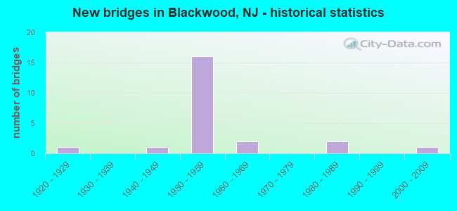
- New bridges - historical statistics
- 11920-1929
- 11940-1949
- 161950-1959
- 21960-1969
- 21980-1989
- 12000-2009


- Bridge Condition - Deck
- 7.1%Good
- 85.7%Satisfactory
- 7.1%Fair

- Bridge Condition - Superstructure
- 7.1%Very good
- 50.0%Good
- 28.6%Satisfactory
- 14.3%Fair

- Bridge Condition - Substructure
- 21.4%Good
- 71.4%Satisfactory
- 7.1%Fair

- Bridge Condition - Channel
- 42.9%Good
- 57.1%Satisfactory
Find on map >> Show street view
Structure Number: 411153, Location: 0.33 MILES N OF CR168 (Lat: 39.783689, Lng: -75.049139), Route carried "on" structure: County highway 673, Year Built: 1958, Year Reconstructed: 1994, Status: Open, Structure Length: 7.07m (23.20ft), Average Daily Traffic: 14,544 (year 2020), Truck Traffic: 4%, Average Future Daily Traffic: 17,454 (year 2040), Design Load: HS 20, Features Intersected: ROUTE NJ 42
Minimum Vertical Clearance: 30+ m (98+ ft), Kilometerpoint: 0.531, Lanes on structure: 2, Lanes under structure: 6, Owner: State Highway Agency, Approaching Roadway Width: 11.0m (36.1ft), Skew: 4 degrees, Material/Design: Steel, Design/Construction: Stringer/Multi-beam, Number Of Spans In Main Unit: 2, Length of Maximum Span: 34.4m (112.9ft), Curb or Sidewalk Widths: Left: 1.8m (5.9ft), Right: 1.8m (5.9ft), Curb-To-Curb Width: 11.0m (36.1ft), Out-to-Out Width: 15.2m (49.9ft)
Condition: Deck: Satisfactory, Superstructure: Good, Substructure: Good, Operating Rating: 89.8 metric tons, Method Used To Determine Operating Rating: Load Factor (LF), Inventory Rating: 53.5 metric tons, Method Used To Determine Inventory Rating: Load Factor (LF), Structural Evaluation: Better than present minimum criteria, Deck Geometry: Meets minimum limits, Underclear: Meets minimum limits, Approach Roadway Alignment: Better than present minimum criteria, Designated Inspection Frequency: Every 24 months, Inspection Date: July 2020, Deck Structure Type: Concrete Cast-file-Place, Wearing Surface/Protective System: Wearing Surface: Latex Concrete
Find on map >> Show street view
Structure Number: 411154, Location: .78 MILE SOUTH OF 534 JCT (Lat: 39.791969, Lng: -75.050139), Route carried "on" structure: Other road , Year Built: 1958, Status: Open, Structure Length: 5.24m (17.19ft), Average Daily Traffic: 9,431 (year 2020), Truck Traffic: 3%, Average Future Daily Traffic: 11,507 (year 2040), Design Load: HS 20, Features Intersected: NJ 42, Facility Carried by Structure: DAVISTOWN RD
Minimum Vertical Clearance: 30+ m (98+ ft), Kilometerpoint: 0.789, Lanes on structure: 2, Lanes under structure: 6, Owner: State Highway Agency, Approaching Roadway Width: 11.0m (36.1ft), Skew: 1 degrees, Material/Design: Steel, Design/Construction: Stringer/Multi-beam, Number Of Spans In Main Unit: 2, Length of Maximum Span: 25.0m (82.0ft), Curb or Sidewalk Widths: Left: 1.8m (5.9ft), Right: 1.8m (5.9ft), Curb-To-Curb Width: 11.0m (36.1ft), Out-to-Out Width: 15.2m (49.9ft)
Condition: Deck: Satisfactory, Superstructure: Good, Substructure: Good, Inventory Rating: 54.4 metric tons, Method Used To Determine Inventory Rating: Load Factor (LF), Structural Evaluation: Better than present minimum criteria, Deck Geometry: Meets minimum limits, Underclear: Meets minimum limits, Approach Roadway Alignment: Equal to present minimum criteria, Designated Inspection Frequency: Every 24 months, Inspection Date: November 2020, Deck Structure Type: Concrete Cast-file-Place, Wearing Surface/Protective System: Wearing Surface: Monolithic Concrete
Find on map >> Show street view
Structure Number: 411156, Location: 0.67 MI S OF COLES ROAD (Lat: 39.802519, Lng: -75.054981), Route carried "on" structure: State highway 42, Year Built: 1958, Status: Open, Structure Length: 2.26m (7.41ft), Average Daily Traffic: 69,353 (year 2020), Truck Traffic: 5%, Average Future Daily Traffic: 84,624 (year 2040), Design Load: HS 20, Features Intersected: BLCKWD CLEM. RD (CR 534)
Minimum Vertical Clearance: 30+ m (98+ ft), Kilometerpoint: 14.178, Lanes on structure: 4, Lanes under structure: 4, Base Highway Network: Yes, Owner: State Highway Agency, Approaching Roadway Width: 15.5m (50.9ft), Skew: 2 degrees, Material/Design: Steel, Design/Construction: Stringer/Multi-beam, Number Of Spans In Main Unit: 1, Length of Maximum Span: 21.3m (69.9ft), Curb or Sidewalk Widths: Left: 0.5m (1.6ft), Right: 0.9m (3.0ft), Curb-To-Curb Width: 15.5m (50.9ft), Out-to-Out Width: 18.0m (59.1ft)
Condition: Deck: Satisfactory, Superstructure: Good, Substructure: Satisfactory, Operating Rating: 89.8 metric tons, Method Used To Determine Operating Rating: Load Factor (LF), Inventory Rating: 61.7 metric tons, Method Used To Determine Inventory Rating: Load Factor (LF), Structural Evaluation: Equal to present minimum criteria, Deck Geometry: High priority of replacement, Underclear: Meets minimum limits, Approach Roadway Alignment: Superior to present desirable criteria, Designated Inspection Frequency: Every 24 months, Inspection Date: September 2020, Deck Structure Type: Concrete Cast-file-Place, Wearing Surface/Protective System: Wearing Surface: Bituminous
Find on map >> Show street view
Structure Number: 411157, Location: 1.2 MI S OF 42-168 JCT (Lat: 39.802669, Lng: -75.055719), Route carried "on" structure: State highway 42, Year Built: 1958, Status: Open, Structure Length: 2.26m (7.41ft), Average Daily Traffic: 69,223 (year 2020), Truck Traffic: 5%, Average Future Daily Traffic: 83,068 (year 2040), Design Load: HS 20, Features Intersected: BLACKWOOD CLEMENTON ROAD
Minimum Vertical Clearance: 30+ m (98+ ft), Kilometerpoint: 14.178, Lanes on structure: 4, Lanes under structure: 4, Base Highway Network: Yes, Owner: State Highway Agency, Approaching Roadway Width: 16.2m (53.1ft), Skew: 2 degrees, Material/Design: Steel, Design/Construction: Stringer/Multi-beam, Number Of Spans In Main Unit: 1, Length of Maximum Span: 21.3m (69.9ft), Curb or Sidewalk Widths: Left: 0.9m (3.0ft), Right: 0.5m (1.6ft), Curb-To-Curb Width: 16.2m (53.1ft), Out-to-Out Width: 18.6m (61.0ft)
Condition: Deck: Fair, Superstructure: Good, Substructure: Satisfactory, Inventory Rating: 55.3 metric tons, Method Used To Determine Inventory Rating: Load Factor (LF), Structural Evaluation: Equal to present minimum criteria, Deck Geometry: High priority of replacement, Underclear: Meets minimum limits, Approach Roadway Alignment: Equal to present desirable criteria, Length Of Structure Improvement: 2.30m (7.55ft), Designated Inspection Frequency: Every 24 months, Inspection Date: September 2020, Bridge Improvement Cost: $132,000, Roadway Improvement Cost: $32,000, Total Project Cost: $336,000 ( Estimate for 2020), Deck Structure Type: Concrete Cast-file-Place, Wearing Surface/Protective System: Wearing Surface: Bituminous
Find on map >> Show street view
Structure Number: 411158, Location: 0.36 MILE EAST OF 168 JCT (Lat: 39.811031, Lng: -75.061861), Route carried "on" structure: City street , Year Built: 1957, Status: Open, Structure Length: 6.52m (21.39ft), Average Daily Traffic: 6,630 (year 2020), Truck Traffic: 4%, Average Future Daily Traffic: 7,956 (year 2040), Design Load: HS 20, Features Intersected: ROUTE NJ 42, Facility Carried by Structure: COLES ROAD
Minimum Vertical Clearance: 30+ m (98+ ft), Kilometerpoint: 0.579, Lanes on structure: 2, Lanes under structure: 7, Owner: State Highway Agency, Approaching Roadway Width: 14.0m (45.9ft), Skew: 3 degrees, Material/Design: Steel, Design/Construction: Stringer/Multi-beam, Number Of Spans In Main Unit: 2, Length of Maximum Span: 32.3m (106.0ft), Curb or Sidewalk Widths: Left: 1.8m (5.9ft), Right: 1.8m (5.9ft), Curb-To-Curb Width: 14.0m (45.9ft), Out-to-Out Width: 18.3m (60.0ft)
Condition: Deck: Satisfactory, Superstructure: Good, Substructure: Satisfactory, Inventory Rating: 58.1 metric tons, Method Used To Determine Inventory Rating: Load Factor (LF), Structural Evaluation: Equal to present minimum criteria, Deck Geometry: Superior to present desirable criteria, Underclear: High priority of corrective action, Approach Roadway Alignment: Better than present minimum criteria, Length Of Structure Improvement: 7.62m (25.00ft), Designated Inspection Frequency: Every 24 months, Inspection Date: September 2020, Bridge Improvement Cost: $700,000, Roadway Improvement Cost: $140,000, Total Project Cost: $1,063,000 ( Estimate for 2020), Deck Structure Type: Concrete Cast-file-Place, Wearing Surface/Protective System: Wearing Surface: Monolithic Concrete
Find on map >> Show street view
Structure Number: 411159, Location: JCT OF NJ 42 & NJ 168 (Lat: 39.816581, Lng: -75.068031), Route carried "on" structure: State highway 42, Year Built: 1956, Status: Open, Structure Length: 2.83m (9.28ft), Average Daily Traffic: 66,325 (year 2020), Truck Traffic: 5%, Average Future Daily Traffic: 79,590 (year 2040), Design Load: HS 20, Features Intersected: NJ 168
Minimum Vertical Clearance: 30+ m (98+ ft), Kilometerpoint: 16.093, Lanes on structure: 4, Lanes under structure: 4, Base Highway Network: Yes, Owner: State Highway Agency, Approaching Roadway Width: 16.2m (53.1ft), Skew: 3 degrees, Material/Design: Steel, Design/Construction: Stringer/Multi-beam, Number Of Spans In Main Unit: 1, Length of Maximum Span: 25.9m (85.0ft), Curb or Sidewalk Widths: Left: 0.7m (2.3ft), Right: 0.7m (2.3ft), Curb-To-Curb Width: 16.2m (53.1ft), Out-to-Out Width: 18.6m (61.0ft)
Condition: Deck: Satisfactory, Superstructure: Good, Substructure: Satisfactory, Operating Rating: 85.3 metric tons, Method Used To Determine Operating Rating: Load Factor (LF), Inventory Rating: 50.8 metric tons, Method Used To Determine Inventory Rating: Load Factor (LF), Structural Evaluation: Equal to present minimum criteria, Deck Geometry: High priority of replacement, Underclear: Equal to present minimum criteria, Approach Roadway Alignment: Better than present minimum criteria, Length Of Structure Improvement: 2.83m (9.28ft), Designated Inspection Frequency: Every 24 months, Inspection Date: August 2020, Bridge Improvement Cost: $252,000, Roadway Improvement Cost: $38,000, Total Project Cost: $391,000 ( Estimate for 2020), Deck Structure Type: Concrete Cast-file-Place, Wearing Surface/Protective System: Wearing Surface: Bituminous
Find on map >> Show street view
Structure Number: 41116, Location: JCT OF RT 42 & 168 (Lat: 39.816611, Lng: -75.068311), Route carried "on" structure: State highway 42, Year Built: 1956, Status: Open, Structure Length: 2.83m (9.28ft), Average Daily Traffic: 64,080 (year 2020), Truck Traffic: 5%, Average Future Daily Traffic: 76,908 (year 2040), Design Load: HS 20, Features Intersected: ROUTE NJ 168
Minimum Vertical Clearance: 30+ m (98+ ft), Kilometerpoint: 16.093, Lanes on structure: 4, Lanes under structure: 4, Base Highway Network: Yes, Owner: State Highway Agency, Approaching Roadway Width: 15.5m (50.9ft), Skew: 3 degrees, Material/Design: Steel, Design/Construction: Stringer/Multi-beam, Number Of Spans In Main Unit: 1, Length of Maximum Span: 25.9m (85.0ft), Curb or Sidewalk Widths: Left: 0.3m (1.0ft), Right: 0.3m (1.0ft), Curb-To-Curb Width: 15.5m (50.9ft), Out-to-Out Width: 18.0m (59.1ft)
Condition: Deck: Satisfactory, Superstructure: Good, Substructure: Satisfactory, Operating Rating: 87.1 metric tons, Method Used To Determine Operating Rating: Load Factor (LF), Inventory Rating: 51.7 metric tons, Method Used To Determine Inventory Rating: Load Factor (LF), Structural Evaluation: Equal to present minimum criteria, Deck Geometry: High priority of replacement, Underclear: Equal to present minimum criteria, Approach Roadway Alignment: Better than present minimum criteria, Length Of Structure Improvement: 2.80m (9.19ft), Designated Inspection Frequency: Every 24 months, Inspection Date: August 2020, Bridge Improvement Cost: $228,000, Roadway Improvement Cost: $34,000, Total Project Cost: $353,000 ( Estimate for 2020), Deck Structure Type: Concrete Cast-file-Place, Wearing Surface/Protective System: Wearing Surface: Bituminous
Find on map >> Show street view
Structure Number: 411162, Location: .2 MILE NORTH OF 168 JCT (Lat: 39.818000, Lng: -75.071100), Route carried "on" structure: State highway 42, Year Built: 1957, Status: Open, Structure Length: 4.51m (14.80ft), Average Daily Traffic: 58,667 (year 2020), Truck Traffic: 5%, Average Future Daily Traffic: 105,600 (year 2040), Design Load: HS 20, Features Intersected: CONRAIL (ABANDONED)
Minimum Vertical Clearance: 30.45m (99.90ft), Kilometerpoint: 16.431, Lanes on structure: 4, Base Highway Network: Yes, Owner: State Highway Agency, Approaching Roadway Width: 16.2m (53.1ft), Skew: 4 degrees, Material/Design: Steel, Design/Construction: Stringer/Multi-beam, Number Of Spans In Main Unit: 3, Length of Maximum Span: 16.8m (55.1ft), Curb or Sidewalk Widths: Left: 1.1m (3.6ft), Right: 0.5m (1.6ft), Curb-To-Curb Width: 16.2m (53.1ft), Out-to-Out Width: 18.7m (61.4ft)
Condition: Deck: Satisfactory, Superstructure: Fair, Substructure: Satisfactory, Operating Rating: 80.7 metric tons, Method Used To Determine Operating Rating: Load Factor (LF), Inventory Rating: 48.1 metric tons, Method Used To Determine Inventory Rating: Load Factor (LF), Structural Evaluation: Somewhat better than minimum adequacy, Deck Geometry: High priority of replacement, Approach Roadway Alignment: Equal to present desirable criteria, Length Of Structure Improvement: 4.51m (14.80ft), Designated Inspection Frequency: Every 24 months, Inspection Date: August 2020, Bridge Improvement Cost: $356,000, Roadway Improvement Cost: $26,000, Total Project Cost: $506,000 ( Estimate for 2020), Deck Structure Type: Concrete Cast-file-Place, Wearing Surface/Protective System: Wearing Surface: Bituminous
Find on map >> Show street view
Structure Number: 48B001, Location: 1.49 MI S OF RT 42 (Lat: 39.804919, Lng: -75.075489), Route carried "on" structure: County highway 681, Year Built: 2005, Status: Open, Structure Length: 1.98m (6.50ft), Average Daily Traffic: 5,202 (year 2021), Truck Traffic: 4%, Average Future Daily Traffic: 6,242 (year 2041), Design Load: HS 25 or greater, Features Intersected: S BR BIG TIMBER CREEK
Minimum Vertical Clearance: 30+ m (98+ ft), Kilometerpoint: 0.000, Lanes on structure: 2, Owner: County Highway Agency, Approaching Roadway Width: 9.1m (29.9ft), Material/Design: Prestressed concrete, Design/Construction: Slab, Number Of Spans In Main Unit: 2, Length of Maximum Span: 9.1m (29.9ft), Curb or Sidewalk Widths: Left: 1.7m (5.6ft), Right: 1.7m (5.6ft), Curb-To-Curb Width: 9.1m (29.9ft), Out-to-Out Width: 13.4m (44.0ft)
Condition: Deck: Good, Superstructure: Very good, Substructure: Good, Channel: Satisfactory, Operating Rating: 74.4 metric tons, Method Used To Determine Operating Rating: Load Factor (LF), Inventory Rating: 35.4 metric tons, Method Used To Determine Inventory Rating: Load Factor (LF), Structural Evaluation: Better than present minimum criteria, Deck Geometry: High priority of corrective action, Waterway Adequacy: Equal to present desirable criteria, Approach Roadway Alignment: Equal to present desirable criteria, Length Of Structure Improvement: 1.98m (6.50ft), Designated Inspection Frequency: Every 24 months, Underwater Inspection Frequency: Every 48 months, Inspection Date: Febuary 2021, Underwater Inspection Date: Febuary 2021, Bridge Improvement Cost: $9,000, Roadway Improvement Cost: $9,000, Total Project Cost: $28,000 ( Estimate for 2021), Deck Structure Type: Concrete Precast Panels, Wearing Surface/Protective System: Wearing Surface: Bituminous, Membrane: Preformed Fabric, Deck Protection: Epoxy Coated Reinforcing
Find on map >> Show street view
Structure Number: 48B002, Location: .39 MILE WEST OF NJ 168 (Lat: 39.801919, Lng: -75.073300), Route carried "on" structure: County highway 534, Year Built: 1922, Status: Open, Structure Length: 0.73m (2.40ft), Average Daily Traffic: 11,124 (year 2021), Truck Traffic: 4%, Average Future Daily Traffic: 13,349 (year 2041), Design Load: H 20, Features Intersected: SO.BR TIMBER CREEK
Minimum Vertical Clearance: 30+ m (98+ ft), Kilometerpoint: 6.486, Lanes on structure: 2, Owner: County Highway Agency, Approaching Roadway Width: 9.1m (29.9ft), Material/Design: Concrete, Design/Construction: Slab, Number Of Spans In Main Unit: 3, Length of Maximum Span: 2.1m (6.9ft), Curb or Sidewalk Widths: Left: 3.0m (9.8ft), Right: 3.8m (12.5ft), Curb-To-Curb Width: 9.1m (29.9ft), Out-to-Out Width: 16.8m (55.1ft)
Condition: Deck: Satisfactory, Superstructure: Satisfactory, Substructure: Satisfactory, Channel: Good, Operating Rating: 52.6 metric tons, Method Used To Determine Operating Rating: Load Factor (LF), Inventory Rating: 31.8 metric tons, Method Used To Determine Inventory Rating: Load Factor (LF), Structural Evaluation: Equal to present minimum criteria, Deck Geometry: High priority of corrective action, Waterway Adequacy: Equal to present minimum criteria, Approach Roadway Alignment: Equal to present minimum criteria, Length Of Structure Improvement: 0.73m (2.40ft), Designated Inspection Frequency: Every 24 months, Inspection Date: March 2021, Bridge Improvement Cost: $40,000, Roadway Improvement Cost: $30,000, Total Project Cost: $121,000 ( Estimate for 2021), Deck Structure Type: Concrete Cast-file-Place, Wearing Surface/Protective System: Wearing Surface: Monolithic Concrete
Find on map >> Show street view
Structure Number: 48C011, Location: 0.36 MI W OF TR 168 (Lat: 39.786939, Lng: -75.064581), Route carried "on" structure: County highway 747, Year Built: 1941, Status: Open, Structure Length: 1.07m (3.51ft), Average Daily Traffic: 5,817 (year 2021), Truck Traffic: 4%, Average Future Daily Traffic: 68,981 (year 2041), Design Load: H 20, Features Intersected: S BRANCH TIMBER CREEK, Facility Carried by Structure: LAKELAND ROAD
Minimum Vertical Clearance: 30+ m (98+ ft), Kilometerpoint: 0.547, Lanes on structure: 2, Owner: County Highway Agency, Approaching Roadway Width: 10.4m (34.1ft), Material/Design: Concrete, Design/Construction: Frame, Number Of Spans In Main Unit: 1, Length of Maximum Span: 9.1m (29.9ft), Curb or Sidewalk Widths: Left: 2.4m (7.9ft), Right: 2.4m (7.9ft), Curb-To-Curb Width: 10.5m (34.4ft), Out-to-Out Width: 16.1m (52.8ft)
Condition: Deck: Satisfactory, Superstructure: Satisfactory, Substructure: Satisfactory, Channel: Satisfactory, Inventory Rating: 72.6 metric tons, Method Used To Determine Inventory Rating: Load Factor (LF), Structural Evaluation: Equal to present minimum criteria, Deck Geometry: Meets minimum limits, Waterway Adequacy: Superior to present desirable criteria, Approach Roadway Alignment: Equal to present desirable criteria, Designated Inspection Frequency: Every 24 months, Inspection Date: March 2021, Deck Structure Type: Concrete Cast-file-Place, Wearing Surface/Protective System: Wearing Surface: Bituminous
Find on map >> Show street view
Structure Number: 48C023, Location: 0.14 MI W OF LAKELAND RD (Lat: 39.788019, Lng: -75.067519), Route carried "on" structure: City street , Year Built: 1950, Status: Posted for load, Structure Length: 0.70m (2.30ft), Average Daily Traffic: 65 (year 2021), Truck Traffic: 1%, Average Future Daily Traffic: 78 (year 2041), Features Intersected: SO BR TIMBER CREEK, Facility Carried by Structure: LAKELAND SWR PT RD
Minimum Vertical Clearance: 30+ m (98+ ft), Kilometerpoint: 0.000, Lanes on structure: 1, Owner: County Highway Agency, Approaching Roadway Width: 4.6m (15.1ft), Material/Design: Steel, Design/Construction: Stringer/Multi-beam, Number Of Spans In Main Unit: 1, Length of Maximum Span: 5.8m (19.0ft), Curb-To-Curb Width: 4.8m (15.7ft), Out-to-Out Width: 5.3m (17.4ft)
Condition: Deck: Satisfactory, Superstructure: Satisfactory, Substructure: Satisfactory, Channel: Satisfactory, Operating Rating: 26.3 metric tons, Method Used To Determine Operating Rating: Load Factor (LF), Inventory Rating: 15.4 metric tons, Method Used To Determine Inventory Rating: Load Factor (LF), Structural Evaluation: Meets minimum limits, Deck Geometry: Equal to present desirable criteria, Waterway Adequacy: Equal to present desirable criteria, Approach Roadway Alignment: Meets minimum limits, Bridge Posting: Required (Relationship of Operating Rating to Maximum Legal Load: 0.1 - 9.9% below), Designated Inspection Frequency: Every 24 months, Other Special Inspection Frequency: Every 12 months, Inspection Date: March 2021, Other Special Inspection Date: March 2021, Deck Structure Type: Concrete Cast-file-Place, Wearing Surface/Protective System: Wearing Surface: Monolithic Concrete
Find on map >> Show street view
Structure Number: 803K04, Location: 0.97 mi EAST of RT NJ 55 (Lat: 39.814939, Lng: -75.088869), Route carried "on" structure: County highway 706, Year Built: 1984, Status: Open, Structure Length: 2.96m (9.71ft), Average Daily Traffic: 8,920 (year 2020), Truck Traffic: 4%, Average Future Daily Traffic: 10,704 (year 2040), Design Load: HS 20+Mod, Features Intersected: BIG TIMBER CREEK
Minimum Vertical Clearance: 30+ m (98+ ft), Kilometerpoint: 2.559, Lanes on structure: 2, Owner: County Highway Agency, Approaching Roadway Width: 12.2m (40.0ft), Material/Design: Prestressed concrete, Design/Construction: Box Beam or Girders - Multiple, Number Of Spans In Main Unit: 2, Length of Maximum Span: 14.0m (45.9ft), Curb or Sidewalk Widths: Left: 1.2m (3.9ft), Right: 0.3m (1.0ft), Curb-To-Curb Width: 15.5m (50.9ft), Out-to-Out Width: 17.5m (57.4ft)
Condition: Deck: Satisfactory, Superstructure: Satisfactory, Substructure: Fair, Channel: Satisfactory, Operating Rating: 48.1 metric tons, Method Used To Determine Operating Rating: Load Factor (LF), Inventory Rating: 29.0 metric tons, Method Used To Determine Inventory Rating: Load Factor (LF), Structural Evaluation: Somewhat better than minimum adequacy, Deck Geometry: Superior to present desirable criteria, Waterway Adequacy: Equal to present minimum criteria, Approach Roadway Alignment: Equal to present minimum criteria, Designated Inspection Frequency: Every 24 months, Underwater Inspection Frequency: Every 48 months, Inspection Date: May 2020, Underwater Inspection Date: May 2020, Deck Structure Type: Concrete Precast Panels, Wearing Surface/Protective System: Wearing Surface: Bituminous, Membrane: Epoxy
Find on map >> Show street view
Structure Number: 820166, Location: 2.0 MI NORTH OF US 322 (Lat: 39.798619, Lng: -75.316411), Route carried "on" structure: Interstate 295, Year Built: 1968, Status: Open, Structure Length: 0.64m (2.10ft), Average Daily Traffic: 58,456 (year 2021), Truck Traffic: 9%, Average Future Daily Traffic: 70,147 (year 2041), Design Load: HS 20, Features Intersected: LITTLE TIMBER CREEK
Minimum Vertical Clearance: 30+ m (98+ ft), Kilometerpoint: 22.402, Lanes on structure: 4, Base Highway Network: Yes, Owner: State Highway Agency, Approaching Roadway Width: 42.1m (138.1ft), Skew: 21 degrees, Material/Design: Concrete, Design/Construction: Culvert, Number Of Spans In Main Unit: 1, Length of Maximum Span: 6.4m (21.0ft)
Condition: Channel: Good, Culverts: Satisfactory, Operating Rating: 63.5 metric tons, Method Used To Determine Operating Rating: Load Factor (LF), Inventory Rating: 38.1 metric tons, Method Used To Determine Inventory Rating: Load Factor (LF), Structural Evaluation: Equal to present minimum criteria, Waterway Adequacy: Equal to present desirable criteria, Approach Roadway Alignment: Better than present minimum criteria, Designated Inspection Frequency: Every 24 months, Inspection Date: November 2021
Find on map >> Show street view
Structure Number: 820167, Location: 2.4 MI NORTH OF US 322 (Lat: 39.802600, Lng: -75.312700), Route carried "on" structure: Ramp US 130, Year Built: 1968, Status: Open, Structure Length: 5.97m (19.59ft), Average Daily Traffic: 12,195 (year 2021), Truck Traffic: 4%, Average Future Daily Traffic: 14,595 (year 2041), Design Load: HS 20+Mod, Features Intersected: I-295
Minimum Vertical Clearance: 30+ m (98+ ft), Kilometerpoint: 22.676, Lanes on structure: 1, Lanes under structure: 5, Base Highway Network: Yes, Owner: State Highway Agency, Approaching Roadway Width: 8.8m (28.9ft), Skew: 3 degrees, Material/Design: Steel, Design/Construction: Stringer/Multi-beam, Number Of Spans In Main Unit: 2, Length of Maximum Span: 29.9m (98.1ft), Curb or Sidewalk Widths: Left: 0.8m (2.6ft), Right: 0.8m (2.6ft), Curb-To-Curb Width: 8.8m (28.9ft), Out-to-Out Width: 11.1m (36.4ft)
Condition: Deck: Satisfactory, Superstructure: Fair, Substructure: Satisfactory, Operating Rating: 78.0 metric tons, Method Used To Determine Operating Rating: Load Factor (LF), Inventory Rating: 46.3 metric tons, Method Used To Determine Inventory Rating: Load Factor (LF), Structural Evaluation: Somewhat better than minimum adequacy, Deck Geometry: Superior to present desirable criteria, Underclear: Somewhat better than minimum adequacy, Approach Roadway Alignment: Meets minimum limits, Designated Inspection Frequency: Every 24 months, Inspection Date: November 2021, Deck Structure Type: Concrete Cast-file-Place, Wearing Surface/Protective System: Wearing Surface: Monolithic Concrete
Find on map >> Show street view
Structure Number: 832163, Location: 1.60 MILE S OF NJ 42 (Lat: 39.807969, Lng: -75.104581), Route carried "on" structure: State highway 55, Year Built: 1985, Status: Open, Structure Length: 1.04m (3.41ft), Average Daily Traffic: 79,016 (year 2019), Truck Traffic: 5%, Average Future Daily Traffic: 115,111 (year 2039), Design Load: HS 20+Mod, Features Intersected: ALMONESSON CREEK
Minimum Vertical Clearance: 30+ m (98+ ft), Kilometerpoint: 92.376, Lanes on structure: 4, Base Highway Network: Yes, Owner: State Highway Agency, Approaching Roadway Width: 25.6m (84.0ft), Skew: 22 degrees, Material/Design: Concrete continuous, Design/Construction: Culvert, Number Of Spans In Main Unit: 2, Length of Maximum Span: 4.6m (15.1ft)
Condition: Channel: Good, Culverts: Satisfactory, Structural Evaluation: Equal to present minimum criteria, Waterway Adequacy: Superior to present desirable criteria, Approach Roadway Alignment: Equal to present desirable criteria, Designated Inspection Frequency: Every 24 months, Inspection Date: November 2021
Find on map >> Show street view
Structure Number: 411153, Location: 0.33 MILES N OF CR168 (Lat: 39.783689, Lng: -75.049139), Route carried "under" structure: State highway 42, Year Built: 1958, Structure Length: 0. m, Average Daily Traffic: 96,217 (year 2020), Truck Traffic: 5%, Features Intersected: ROUTE NJ 42, Facility Carried by Structure: COLLEGE DR (CR673)
Minimum Vertical Clearance: 4.75m (15.58ft), Kilometerpoint: 12.038, Lanes on structure: 2, Lanes under structure: 6, Material/Design: Steel, Design/Construction: Stringer/Multi-beam, Length of Maximum Span: 34.4m (112.9ft)
Find on map >> Show street view
Structure Number: 411154, Location: .78 MILE SOUTH OF 534 JCT (Lat: 39.791969, Lng: -75.050139), Route carried "under" structure: State highway 42, Year Built: 1958, Structure Length: 0. m, Average Daily Traffic: 138,496 (year 2020), Truck Traffic: 5%, Features Intersected: NJ 42, Facility Carried by Structure: DAVISTOWN RD
Minimum Vertical Clearance: 4.75m (15.58ft), Kilometerpoint: 12.923, Lanes on structure: 2, Lanes under structure: 6, Material/Design: Steel, Design/Construction: Stringer/Multi-beam, Length of Maximum Span: 25.0m (82.0ft)
Find on map >> Show street view
Structure Number: 411156, Location: 0.67 MI S OF COLES ROAD (Lat: 39.802519, Lng: -75.054981), Route carried "under" structure: County highway 534, Year Built: 1958, Structure Length: 0. m, Average Daily Traffic: 21,375 (year 2020), Truck Traffic: 5%, Features Intersected: BLCKWD CLEM. RD (CR 534), Facility Carried by Structure: NJ-42
Minimum Vertical Clearance: 4.88m (16.01ft), Kilometerpoint: 8.111, Lanes on structure: 4, Lanes under structure: 4, Material/Design: Steel, Design/Construction: Stringer/Multi-beam, Length of Maximum Span: 21.3m (69.9ft)
Find on map >> Show street view
Structure Number: 411157, Location: 1.2 MI S OF 42-168 JCT (Lat: 39.802669, Lng: -75.055719), Route carried "under" structure: County highway 534, Year Built: 1958, Structure Length: 0. m, Average Daily Traffic: 29,425 (year 2020), Truck Traffic: 4%, Features Intersected: BLACKWOOD CLEMENTON ROAD, Facility Carried by Structure: RT NJ42 SOUTHBOUND
Minimum Vertical Clearance: 4.55m (14.93ft), Kilometerpoint: 7.162, Lanes on structure: 4, Lanes under structure: 4, Material/Design: Steel, Design/Construction: Stringer/Multi-beam, Length of Maximum Span: 21.3m (69.9ft)
Find on map >> Show street view
Structure Number: 411158, Location: 0.36 MILE EAST OF 168 JCT (Lat: 39.811031, Lng: -75.061861), Route carried "under" structure: State highway 42, Year Built: 1957, Structure Length: 0. m, Average Daily Traffic: 134,600 (year 2020), Truck Traffic: 5%, Features Intersected: ROUTE NJ 42, Facility Carried by Structure: COLES ROAD
Minimum Vertical Clearance: 5.36m (17.59ft), Kilometerpoint: 15.257, Lanes on structure: 2, Lanes under structure: 7, Material/Design: Steel, Design/Construction: Stringer/Multi-beam, Length of Maximum Span: 32.3m (106.0ft)
Find on map >> Show street view
Structure Number: 411159, Location: JCT OF NJ 42 & NJ 168 (Lat: 39.816581, Lng: -75.068031), Route carried "under" structure: State highway 168, Year Built: 1956, Structure Length: 0. m, Average Daily Traffic: 16,044 (year 2020), Truck Traffic: 4%, Features Intersected: NJ 168, Facility Carried by Structure: NJ 42 NB
Minimum Vertical Clearance: 4.52m (14.83ft), Kilometerpoint: 5.536, Lanes on structure: 4, Lanes under structure: 4, Material/Design: Steel, Design/Construction: Stringer/Multi-beam, Length of Maximum Span: 25.9m (85.0ft)
Find on map >> Show street view
Structure Number: 41116, Location: JCT OF RT 42 & 168 (Lat: 39.816611, Lng: -75.068311), Route carried "under" structure: State highway 168, Year Built: 1956, Structure Length: 0. m, Average Daily Traffic: 15,820 (year 2020), Truck Traffic: 4%, Features Intersected: ROUTE NJ 168, Facility Carried by Structure: ROUTE NJ 42 SB
Minimum Vertical Clearance: 4.57m (14.99ft), Kilometerpoint: 5.504, Lanes on structure: 4, Lanes under structure: 4, Material/Design: Steel, Design/Construction: Stringer/Multi-beam, Length of Maximum Span: 25.9m (85.0ft)