Bridge Statistics for Blairsburg, Iowa (IA)
Condition, Traffic, Stress, Structural Evaluation, Project Costs
- National Bridge Inventory (NBI) Statistics
- 13Number of bridges
- 89ft / 26.6mTotal length
- 46,080Total average daily traffic
- 12,273Total average daily truck traffic
- National Bridge Inventory (NBI) Registered Bridges for Blairsburg
- No street view available for this location
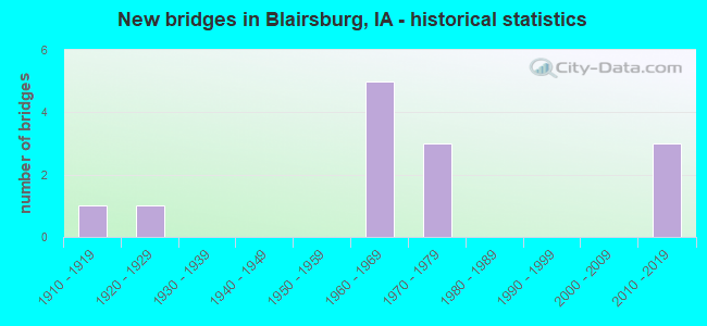
- New bridges - historical statistics
- 11910-1919
- 11920-1929
- 51960-1969
- 31970-1979
- 32010-2019


- Bridge Condition - Deck
- 20.0%Very good
- 40.0%Good
- 20.0%Fair
- 20.0%Serious

- Bridge Condition - Superstructure
- 60.0%Very good
- 20.0%Poor
- 20.0%Serious

- Bridge Condition - Substructure
- 40.0%Good
- 20.0%Satisfactory
- 40.0%Poor

- Bridge Condition - Channel
- 28.6%Very good
- 28.6%Good
- 42.9%Satisfactory

- Bridge Condition - Culverts
- 60.0%Very good
- 40.0%Good
Find on map >> Show street view
Structure Number: 2643, Location: AT US 20 / US 69 JUNCTION (Lat: 42.448694, Lng: -93.640219), Route carried "on" structure: US 69, Year Built: 1968, Status: Open, Structure Length: 6.68m (21.92ft), Average Daily Traffic: 1,110 (year 2020), Truck Traffic: 24%, Average Future Daily Traffic: 1,110 (year 2040), Design Load: HS 20, Features Intersected: US 20
Minimum Vertical Clearance: 30+ m (98+ ft), Kilometerpoint: 236.746, Lanes on structure: 2, Lanes under structure: 4, Base Highway Network: Yes, Owner: State Highway Agency, Approaching Roadway Width: 13.4m (44.0ft), Material/Design: Prestressed concrete, Design/Construction: Stringer/Multi-beam, Number Of Spans In Main Unit: 4, Length of Maximum Span: 21.0m (68.9ft), Curb-To-Curb Width: 13.4m (44.0ft), Out-to-Out Width: 14.4m (47.2ft)
Condition: Deck: Good, Superstructure: Very good, Substructure: Good, Operating Rating: 56.7 metric tons, Method Used To Determine Operating Rating: Load Factor (LF), Inventory Rating: 31.5 metric tons, Method Used To Determine Inventory Rating: Load Factor (LF), Structural Evaluation: Better than present minimum criteria, Deck Geometry: Equal to present desirable criteria, Underclear: Equal to present minimum criteria, Approach Roadway Alignment: Better than present minimum criteria, Designated Inspection Frequency: Every 24 months, Inspection Date: May 2020, Deck Structure Type: Concrete Cast-file-Place, Wearing Surface/Protective System: Wearing Surface: Low Slump Concrete
Find on map >> Show street view
Structure Number: 26445, Location: 0.8 MILE N OF JCT. SR D25 (Lat: 42.481719, Lng: -93.636056), Route carried "on" structure: US 69, Year Built: 1973, Status: Open, Structure Length: 5.21m (17.09ft), Average Daily Traffic: 1,050 (year 2020), Truck Traffic: 34%, Average Future Daily Traffic: 1,050 (year 2040), Design Load: HS 20, Features Intersected: CC RR
Minimum Vertical Clearance: 30+ m (98+ ft), Kilometerpoint: 240.544, Lanes on structure: 2, Base Highway Network: Yes, Owner: State Highway Agency, Approaching Roadway Width: 14.6m (47.9ft), Material/Design: Prestressed concrete, Design/Construction: Stringer/Multi-beam, Number Of Spans In Main Unit: 3, Length of Maximum Span: 19.8m (65.0ft), Curb or Sidewalk Widths: Left: 0.3m (1.0ft), Right: 0.3m (1.0ft), Curb-To-Curb Width: 13.4m (44.0ft), Out-to-Out Width: 14.4m (47.2ft)
Condition: Deck: Good, Superstructure: Very good, Substructure: Satisfactory, Operating Rating: 69.2 metric tons, Method Used To Determine Operating Rating: Load Factor (LF), Inventory Rating: 41.5 metric tons, Method Used To Determine Inventory Rating: Load Factor (LF), Structural Evaluation: Equal to present minimum criteria, Deck Geometry: Equal to present desirable criteria, Underclear: Equal to present desirable criteria, Approach Roadway Alignment: Equal to present desirable criteria, Designated Inspection Frequency: Every 24 months, Inspection Date: May 2020, Deck Structure Type: Concrete Cast-file-Place, Wearing Surface/Protective System: Wearing Surface: Monolithic Concrete
Find on map >> Show street view
Structure Number: 2659, Location: 0.7 MILE E OF JCT US 69 (Lat: 42.448878, Lng: -93.625708), Route carried "on" structure: US 20, Year Built: 1968, Status: Open, Structure Length: 0.76m (2.49ft), Average Daily Traffic: 8,700 (year 2020), Truck Traffic: 27%, Average Future Daily Traffic: 8,700 (year 2041), Design Load: HS 20, Features Intersected: DRAINAGE DITCH #4
Minimum Vertical Clearance: 30+ m (98+ ft), Kilometerpoint: 230.788, Lanes on structure: 4, Base Highway Network: Yes, Owner: State Highway Agency, Approaching Roadway Width: 24.4m (80.1ft), Skew: 20 degrees, Material/Design: Concrete continuous, Design/Construction: Culvert, Number Of Spans In Main Unit: 2, Length of Maximum Span: 3.7m (12.1ft)
Condition: Channel: Good, Culverts: Good, Operating Rating: 97.2 metric tons, Method Used To Determine Operating Rating: Load Factor (LF) rating reported by rating factor (RF) method using MS18 loading, Inventory Rating: 61.6 metric tons, Method Used To Determine Inventory Rating: Load Factor (LF) rating reported by rating factor (RF) method using MS18 loading, Structural Evaluation: Better than present minimum criteria, Waterway Adequacy: Equal to present minimum criteria, Approach Roadway Alignment: Equal to present desirable criteria, Designated Inspection Frequency: Every 24 months, Inspection Date: June 2021
Find on map >> Show street view
Structure Number: 2661, Location: 1.8 MILES EAST OF US 69 (Lat: 42.448867, Lng: -93.604772), Route carried "on" structure: US 20, Year Built: 1968, Status: Open, Structure Length: 0.76m (2.49ft), Average Daily Traffic: 8,700 (year 2020), Truck Traffic: 27%, Average Future Daily Traffic: 8,700 (year 2041), Design Load: HS 20, Features Intersected: DRAINAGE DITCH #4
Minimum Vertical Clearance: 30+ m (98+ ft), Kilometerpoint: 232.510, Lanes on structure: 4, Base Highway Network: Yes, Owner: State Highway Agency, Approaching Roadway Width: 24.4m (80.1ft), Skew: 20 degrees, Material/Design: Concrete continuous, Design/Construction: Culvert, Number Of Spans In Main Unit: 2, Length of Maximum Span: 3.7m (12.1ft)
Condition: Channel: Satisfactory, Culverts: Good, Operating Rating: 49.2 metric tons, Method Used To Determine Operating Rating: Load Factor (LF) rating reported by rating factor (RF) method using MS18 loading, Inventory Rating: 29.5 metric tons, Method Used To Determine Inventory Rating: Load Factor (LF) rating reported by rating factor (RF) method using MS18 loading, Structural Evaluation: Better than present minimum criteria, Waterway Adequacy: Equal to present minimum criteria, Approach Roadway Alignment: Equal to present desirable criteria, Designated Inspection Frequency: Every 24 months, Inspection Date: June 2021
Find on map >> Show street view
Structure Number: 17173, Location: 088241201 (Lat: 42.456225, Lng: -93.599156), Route carried "on" structure: County highway , Year Built: 1917, Status: Posted for load, Structure Length: 0.94m (3.08ft), Average Daily Traffic: 5 (year 2019), Average Future Daily Traffic: 5 (year 2041), Features Intersected: DRAINAGE DITCH, Facility Carried by Structure: LOCAL
Minimum Vertical Clearance: 30+ m (98+ ft), Kilometerpoint: 17.886, Lanes on structure: 1, Owner: County Highway Agency, Approaching Roadway Width: 7.3m (24.0ft), Skew: 3 degrees, Material/Design: Concrete, Design/Construction: Stringer/Multi-beam, Number Of Spans In Main Unit: 1, Length of Maximum Span: 9.1m (29.9ft), Curb-To-Curb Width: 5.4m (17.7ft), Out-to-Out Width: 6.1m (20.0ft)
Condition: Deck: Serious, Superstructure: Serious, Substructure: Poor, Channel: Satisfactory, Operating Rating: 32.7 metric tons, Method Used To Determine Operating Rating: Allowable Stress (AS), Inventory Rating: 17.1 metric tons, Method Used To Determine Inventory Rating: Allowable Stress (AS), Structural Evaluation: High priority of corrective action, Deck Geometry: High priority of corrective action, Waterway Adequacy: Equal to present minimum criteria, Approach Roadway Alignment: Equal to present minimum criteria, Length Of Structure Improvement: 5.00m (16.40ft), Designated Inspection Frequency: Every 12 months, Inspection Date: September 2021, Bridge Improvement Cost: $132,000, Roadway Improvement Cost: $13,000, Deck Structure Type: Concrete Cast-file-Place, Wearing Surface/Protective System: Wearing Surface: Gravel
Find on map >> Show street view
Structure Number: 171751, Location: 088241402 (Lat: 42.433081, Lng: -93.620572), Route carried "on" structure: County highway , Year Built: 2011, Status: Open, Structure Length: 1.01m (3.31ft), Average Daily Traffic: 10 (year 2019), Average Future Daily Traffic: 10 (year 2039), Design Load: HS 20, Features Intersected: DRAINAGE DITCH, Facility Carried by Structure: LOCAL
Minimum Vertical Clearance: 30+ m (98+ ft), Kilometerpoint: 19.171, Lanes on structure: 2, Owner: County Highway Agency, Approaching Roadway Width: 6.7m (22.0ft), Skew: 4 degrees, Material/Design: Concrete continuous, Design/Construction: Culvert, Number Of Spans In Main Unit: 2, Length of Maximum Span: 4.9m (16.1ft)
Condition: Channel: Very good, Culverts: Very good, Operating Rating: 44.1 metric tons, Method Used To Determine Operating Rating: Assigned rating based on Load Factor Design (LFD) reported in metric tons, Inventory Rating: 32.7 metric tons, Method Used To Determine Inventory Rating: Assigned rating based on Load Factor Design (LFD) reported in metric tons, Structural Evaluation: Equal to present desirable criteria, Waterway Adequacy: Better than present minimum criteria, Approach Roadway Alignment: Equal to present desirable criteria, Designated Inspection Frequency: Every 48 months, Inspection Date: September 2019
Find on map >> Show street view
Structure Number: 171761, Location: 088241501 (Lat: 42.441703, Lng: -93.628061), Route carried "on" structure: County highway , Year Built: 2011, Status: Open, Structure Length: 0.67m (2.20ft), Average Daily Traffic: 50 (year 2019), Average Future Daily Traffic: 50 (year 2039), Design Load: HS 20, Features Intersected: DRAINAGE DITCH, Facility Carried by Structure: 240TH ST
Minimum Vertical Clearance: 30+ m (98+ ft), Kilometerpoint: 16.971, Lanes on structure: 2, Owner: County Highway Agency, Approaching Roadway Width: 6.7m (22.0ft), Skew: 1 degrees, Material/Design: Concrete continuous, Design/Construction: Culvert, Number Of Spans In Main Unit: 2, Length of Maximum Span: 3.0m (9.8ft)
Condition: Channel: Very good, Culverts: Very good, Operating Rating: 44.1 metric tons, Method Used To Determine Operating Rating: Assigned rating based on Load Factor Design (LFD) reported in metric tons, Inventory Rating: 32.7 metric tons, Method Used To Determine Inventory Rating: Assigned rating based on Load Factor Design (LFD) reported in metric tons, Structural Evaluation: Equal to present desirable criteria, Waterway Adequacy: Better than present minimum criteria, Approach Roadway Alignment: Better than present minimum criteria, Designated Inspection Frequency: Every 48 months, Inspection Date: September 2019
Find on map >> Show street view
Structure Number: 17178, Location: 088242301 (Lat: 42.427186, Lng: -93.616106), Route carried "on" structure: County highway , Year Built: 1923, Status: Posted for load, Structure Length: 1.28m (4.20ft), Average Daily Traffic: 25 (year 2019), Average Future Daily Traffic: 25 (year 2041), Features Intersected: DRAINAGE DITCH, Facility Carried by Structure: FM
Minimum Vertical Clearance: 30+ m (98+ ft), Kilometerpoint: 22.717, Lanes on structure: 2, Owner: County Highway Agency, Approaching Roadway Width: 7.3m (24.0ft), Skew: 4 degrees, Material/Design: Steel, Design/Construction: Stringer/Multi-beam, Number Of Spans In Main Unit: 1, Length of Maximum Span: 12.2m (40.0ft), Curb-To-Curb Width: 5.4m (17.7ft), Out-to-Out Width: 6.1m (20.0ft)
Condition: Deck: Fair, Superstructure: Poor, Substructure: Poor, Channel: Satisfactory, Operating Rating: 35.7 metric tons, Method Used To Determine Operating Rating: Allowable Stress (AS), Inventory Rating: 19.8 metric tons, Method Used To Determine Inventory Rating: Allowable Stress (AS), Structural Evaluation: Meets minimum limits, Deck Geometry: High priority of corrective action, Waterway Adequacy: Equal to present minimum criteria, Approach Roadway Alignment: Somewhat better than minimum adequacy, Bridge Posting: Required (Relationship of Operating Rating to Maximum Legal Load: 0.1 - 9.9% below), Length Of Structure Improvement: 6.50m (21.33ft), Designated Inspection Frequency: Every 24 months, Inspection Date: September 2021, Bridge Improvement Cost: $172,000, Roadway Improvement Cost: $17,000, Deck Structure Type: Concrete Cast-file-Place, Wearing Surface/Protective System: Wearing Surface: Gravel
Find on map >> Show street view
Structure Number: 60337, Location: 2.0 MI. W OF JCT. US 69 (Lat: 42.448333, Lng: -93.679572), Route carried "on" structure: County highway , Year Built: 1975, Status: Open, Structure Length: 8.17m (26.80ft), Average Daily Traffic: 25 (year 2019), Truck Traffic: 4%, Average Future Daily Traffic: 25 (year 2040), Design Load: H 20, Features Intersected: US 20, Facility Carried by Structure: POPLAR GROVE AVE
Minimum Vertical Clearance: 30+ m (98+ ft), Kilometerpoint: 23.327, Lanes on structure: 2, Lanes under structure: 4, Owner: State Highway Agency, Approaching Roadway Width: 9.1m (29.9ft), Material/Design: Prestressed concrete, Design/Construction: Stringer/Multi-beam, Number Of Spans In Main Unit: 4, Length of Maximum Span: 28.0m (91.9ft), Curb or Sidewalk Widths: Left: 0.3m (1.0ft), Right: 0.3m (1.0ft), Curb-To-Curb Width: 9.1m (29.9ft), Out-to-Out Width: 10.1m (33.1ft)
Condition: Deck: Very good, Superstructure: Very good, Substructure: Good, Operating Rating: 74.4 metric tons, Method Used To Determine Operating Rating: Load Factor (LF), Inventory Rating: 26.8 metric tons, Method Used To Determine Inventory Rating: Load Factor (LF), Structural Evaluation: Equal to present minimum criteria, Deck Geometry: Better than present minimum criteria, Underclear: Superior to present desirable criteria, Approach Roadway Alignment: Better than present minimum criteria, Designated Inspection Frequency: Every 24 months, Inspection Date: April 2020, Deck Structure Type: Concrete Cast-file-Place, Wearing Surface/Protective System: Wearing Surface: Monolithic Concrete
Find on map >> Show street view
Structure Number: DAPAMCIOW000925, Location: 1500 FT N OF LINE 3A RD (Lat: 40.797139, Lng: -91.290950), Route carried "on" structure: ServiceOther road , Year Built: 2019, Status: Open, Structure Length: 1.12m (3.67ft), Average Daily Traffic: 5 (year 2020), Truck Traffic: 3%, Average Future Daily Traffic: 10 (year 2042), Design Load: HS 20, Features Intersected: LONG CREEK, Facility Carried by Structure: PLANT RD Q
Minimum Vertical Clearance: 30+ m (98+ ft), Kilometerpoint: 0.000, Lanes on structure: 1, Owner: Army, Approaching Roadway Width: 3.7m (12.1ft), Skew: 3 degrees, Material/Design: Concrete, Design/Construction: Culvert, Number Of Spans In Main Unit: 3, Length of Maximum Span: 3.0m (9.8ft), Curb or Sidewalk Widths: Left: 0.2m (0.7ft), Right: 0.2m (0.7ft)
Condition: Channel: Good, Culverts: Very good, Operating Rating: 42.4 metric tons, Method Used To Determine Operating Rating: Field evaluation and documented engineering judgment, Inventory Rating: 32.7 metric tons, Method Used To Determine Inventory Rating: Field evaluation and documented engineering judgment, Structural Evaluation: Equal to present desirable criteria, Waterway Adequacy: Equal to present desirable criteria, Approach Roadway Alignment: Equal to present minimum criteria, Length Of Structure Improvement: 1.79m (5.87ft), Designated Inspection Frequency: Every 24 months, Inspection Date: March 2020
Find on map >> Show street view
Structure Number: 2643, Location: AT US 20 / US 69 JUNCTION (Lat: 42.448694, Lng: -93.640219), Route carried "under" structure: US 20, Year Built: 1968, Structure Length: 0. m, Average Daily Traffic: 8,500 (year 2020), Truck Traffic: 26%, Features Intersected: US 20, Facility Carried by Structure: US 69
Minimum Vertical Clearance: 30+ m (98+ ft), Kilometerpoint: 229.587, Lanes on structure: 2, Lanes under structure: 4, Material/Design: Prestressed concrete, Design/Construction: Stringer/Multi-beam, Length of Maximum Span: 21.0m (68.9ft)
Find on map >> Show street view
Structure Number: 2662, Location: 1.6 MILES W OF JCT I-35 (Lat: 42.448664, Lng: -93.601114), Route carried "under" structure: US 20, Year Built: 1967, Structure Length: 0. m, Average Daily Traffic: 8,700 (year 2020), Truck Traffic: 27%, Features Intersected: US 20, Facility Carried by Structure: TOLLMAN AVE
Minimum Vertical Clearance: 30+ m (98+ ft), Kilometerpoint: 232.809, Lanes on structure: 2, Lanes under structure: 4, Material/Design: Prestressed concrete, Design/Construction: Stringer/Multi-beam, Length of Maximum Span: 21.0m (68.9ft)
Find on map >> Show street view
Structure Number: 60337, Location: 2.0 MI. W OF JCT. US 69 (Lat: 42.448333, Lng: -93.679572), Route carried "under" structure: US 20, Year Built: 1975, Structure Length: 0. m, Average Daily Traffic: 9,200 (year 2020), Truck Traffic: 26%, Features Intersected: US 20, Facility Carried by Structure: POPLAR GROVE AVE
Minimum Vertical Clearance: 30+ m (98+ ft), Kilometerpoint: 226.353, Lanes on structure: 2, Lanes under structure: 4, Material/Design: Prestressed concrete, Design/Construction: Stringer/Multi-beam, Length of Maximum Span: 28.0m (91.9ft)