Bridge Statistics for Blandon, Pennsylvania (PA)
Condition, Traffic, Stress, Structural Evaluation, Project Costs
- National Bridge Inventory (NBI) Statistics
- 22Number of bridges
- 217ft / 65.8mTotal length
- $4,995,000Total costs
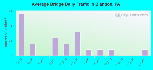
- 157,693Total average daily traffic
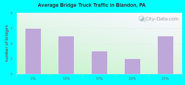
- 23,203Total average daily truck traffic
- National Bridge Inventory (NBI) Registered Bridges for Blandon
- No street view available for this location
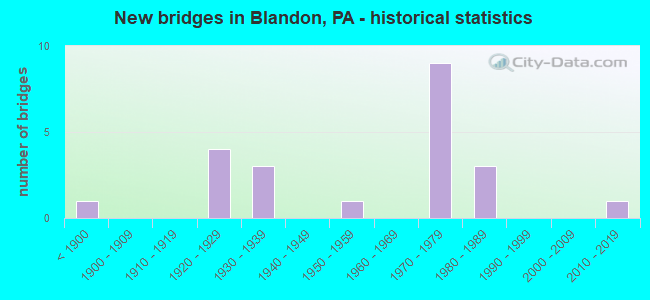
- New bridges - historical statistics
- 1Before 1900
- 41920-1929
- 31930-1939
- 11950-1959
- 91970-1979
- 31980-1989
- 12010-2019
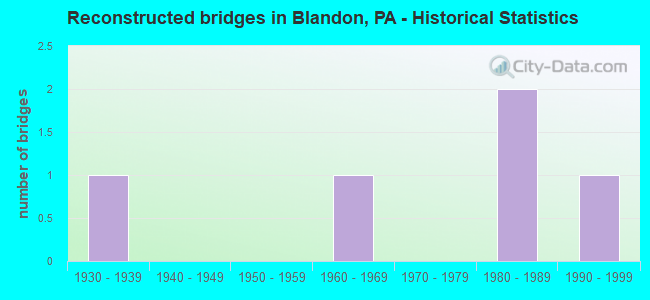
- Reconstructed bridges - Historical Statistics
- 11930-1939
- 01940-1949
- 01950-1959
- 11960-1969
- 01970-1979
- 21980-1989
- 11990-1999
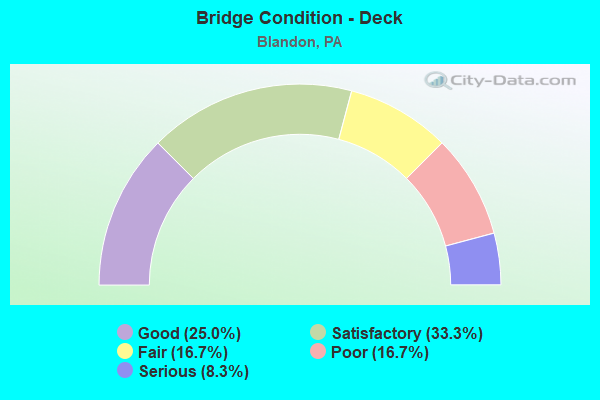
- Bridge Condition - Deck
- 25.0%Good
- 33.3%Satisfactory
- 16.7%Fair
- 16.7%Poor
- 8.3%Serious
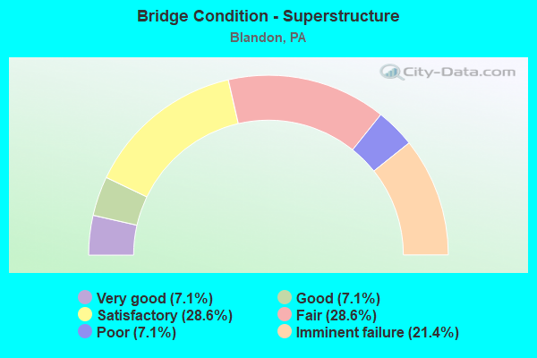
- Bridge Condition - Superstructure
- 7.1%Very good
- 7.1%Good
- 28.6%Satisfactory
- 28.6%Fair
- 7.1%Poor
- 21.4%Imminent failure
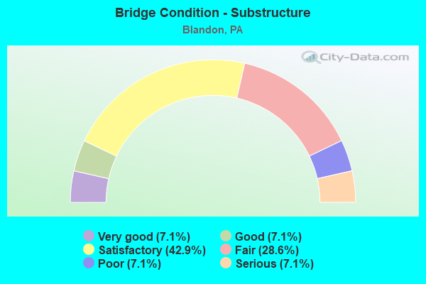
- Bridge Condition - Substructure
- 7.1%Very good
- 7.1%Good
- 42.9%Satisfactory
- 28.6%Fair
- 7.1%Poor
- 7.1%Serious
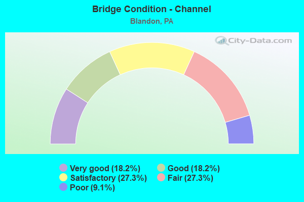
- Bridge Condition - Channel
- 18.2%Very good
- 18.2%Good
- 27.3%Satisfactory
- 27.3%Fair
- 9.1%Poor
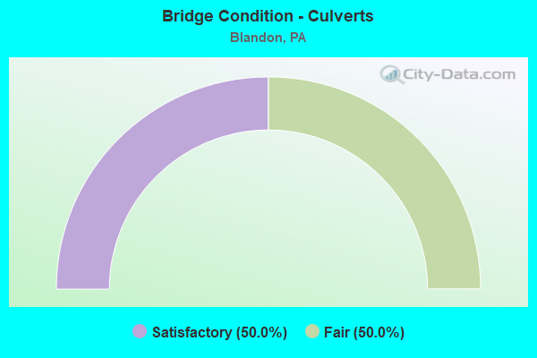
- Bridge Condition - Culverts
- 50.0%Satisfactory
- 50.0%Fair
Find on map >> Show street view
Structure Number: 461, Location: ONTELAUNEE DAM (Lat: 40.446794, Lng: -75.931850), Route carried "on" structure: State highway 73, Year Built: 1935, Year Reconstructed: 1994, Status: Open, Structure Length: 16.58m (54.40ft), Average Daily Traffic: 8,425 (year 2021), Truck Traffic: 12%, Average Future Daily Traffic: 7,164 (year 2032), Design Load: HS 20, Features Intersected: MAIDEN CREEK
Minimum Vertical Clearance: 30+ m (98+ ft), Kilometerpoint: 1.395, Lanes on structure: 2, Owner: City or Municipal Highway Agency, Approaching Roadway Width: 6.7m (22.0ft), Material/Design: Concrete, Design/Construction: Arch - Deck, Number Of Spans In Main Unit: 7, Length of Maximum Span: 22.3m (73.2ft), Curb or Sidewalk Widths: Left: 1.5m (4.9ft), Right: 1.5m (4.9ft), Curb-To-Curb Width: 6.6m (21.7ft), Out-to-Out Width: 10.2m (33.5ft)
Condition: Superstructure: Fair, Substructure: Satisfactory, Channel: Good, Operating Rating: 89.8 metric tons, Method Used To Determine Operating Rating: Load Factor (LF), Inventory Rating: 78.0 metric tons, Method Used To Determine Inventory Rating: Load Factor (LF), Structural Evaluation: Somewhat better than minimum adequacy, Deck Geometry: High priority of replacement, Waterway Adequacy: Superior to present desirable criteria, Approach Roadway Alignment: Equal to present desirable criteria, Length Of Structure Improvement: 17.50m (57.41ft), Designated Inspection Frequency: Every 24 months, Inspection Date: May 2020, Bridge Improvement Cost: $85,000, Roadway Improvement Cost: $249,000, Total Project Cost: $1,143,000
Find on map >> Show street view
Structure Number: 4611, Location: MAIDENCREEK (Lat: 40.450444, Lng: -75.910592), Route carried "on" structure: State highway 73, Year Built: 1935, Status: Open, Structure Length: 1.31m (4.30ft), Average Daily Traffic: 8,425 (year 2021), Truck Traffic: 12%, Average Future Daily Traffic: 7,164 (year 2032), Design Load: HS 20, Features Intersected: NORFOLK SOUTHERN
Minimum Vertical Clearance: 30+ m (98+ ft), Kilometerpoint: 3.022, Lanes on structure: 2, Owner: City or Municipal Highway Agency, Approaching Roadway Width: 7.3m (24.0ft), Skew: 3 degrees, Material/Design: Steel, Design/Construction: Stringer/Multi-beam, Number Of Spans In Main Unit: 1, Length of Maximum Span: 12.2m (40.0ft), Curb or Sidewalk Widths: Left: 0.0m, Right: 1.5m (4.9ft), Curb-To-Curb Width: 7.4m (24.3ft), Out-to-Out Width: 9.8m (32.2ft)
Condition: Deck: Satisfactory, Superstructure: Satisfactory, Substructure: Fair, Operating Rating: 82.6 metric tons, Method Used To Determine Operating Rating: Load Factor (LF), Inventory Rating: 49.9 metric tons, Method Used To Determine Inventory Rating: Load Factor (LF), Structural Evaluation: Somewhat better than minimum adequacy, Deck Geometry: High priority of replacement, Underclear: High priority of corrective action, Approach Roadway Alignment: Equal to present minimum criteria, Length Of Structure Improvement: 2.00m (6.56ft), Designated Inspection Frequency: Every 24 months, Inspection Date: June 2020, Bridge Improvement Cost: $4,000, Roadway Improvement Cost: $13,000, Total Project Cost: $59,000, Deck Structure Type: Concrete Cast-file-Place, Wearing Surface/Protective System: Wearing Surface: Bituminous
Find on map >> Show street view
Structure Number: 4612, Location: 1 MI.N.OF BLANDON (Lat: 40.447247, Lng: -75.896553), Route carried "on" structure: State highway 73, Year Built: 1927, Year Reconstructed: 1973, Status: Open, Structure Length: 2.44m (8.01ft), Average Daily Traffic: 6,669 (year 2022), Truck Traffic: 11%, Average Future Daily Traffic: 11,699 (year 2032), Design Load: HS 20, Features Intersected: WILLOW CREEK
Minimum Vertical Clearance: 30+ m (98+ ft), Kilometerpoint: 4.426, Lanes on structure: 2, Owner: State Highway Agency, Approaching Roadway Width: 7.9m (25.9ft), Skew: 3 degrees, Material/Design: Concrete, Design/Construction: Tee Beam, Number Of Spans In Main Unit: 2, Length of Maximum Span: 11.3m (37.1ft), Curb-To-Curb Width: 12.0m (39.4ft), Out-to-Out Width: 13.1m (43.0ft)
Condition: Deck: Good, Superstructure: Satisfactory, Substructure: Satisfactory, Channel: Fair, Operating Rating: 44.5 metric tons, Method Used To Determine Operating Rating: Load Factor (LF), Inventory Rating: 20.0 metric tons, Method Used To Determine Inventory Rating: Load Factor (LF), Structural Evaluation: Somewhat better than minimum adequacy, Deck Geometry: Somewhat better than minimum adequacy, Waterway Adequacy: Equal to present desirable criteria, Approach Roadway Alignment: Equal to present desirable criteria, Length Of Structure Improvement: 3.20m (10.50ft), Designated Inspection Frequency: Every 24 months, Inspection Date: April 2021, Bridge Improvement Cost: $10,000, Roadway Improvement Cost: $29,000, Total Project Cost: $133,000, Deck Structure Type: Concrete Cast-file-Place, Wearing Surface/Protective System: Wearing Surface: Bituminous
Find on map >> Show street view
Structure Number: 4796, Location: 1 MI S OF PA 73 (Lat: 40.449694, Lng: -75.895972), Route carried "on" structure: US 222, Year Built: 1927, Year Reconstructed: 1985, Status: Open, Structure Length: 4.05m (13.29ft), Average Daily Traffic: 22,646 (year 2022), Truck Traffic: 20%, Average Future Daily Traffic: 33,122 (year 2032), Design Load: HS 20, Features Intersected: WILLOW CREEK
Minimum Vertical Clearance: 30+ m (98+ ft), Kilometerpoint: 29.340, Lanes on structure: 3, Base Highway Network: Yes, Owner: State Highway Agency, Approaching Roadway Width: 12.8m (42.0ft), Skew: 4 degrees, Material/Design: Concrete, Design/Construction: Tee Beam, Number Of Spans In Main Unit: 3, Length of Maximum Span: 13.4m (44.0ft), Curb or Sidewalk Widths: Left: 0.2m (0.7ft), Right: 0.2m (0.7ft), Curb-To-Curb Width: 12.6m (41.3ft), Out-to-Out Width: 13.7m (44.9ft)
Condition: Deck: Fair, Superstructure: Fair, Substructure: Fair, Channel: Fair, Operating Rating: 53.5 metric tons, Method Used To Determine Operating Rating: Load Factor (LF), Inventory Rating: 31.8 metric tons, Method Used To Determine Inventory Rating: Load Factor (LF), Structural Evaluation: Somewhat better than minimum adequacy, Deck Geometry: Meets minimum limits, Waterway Adequacy: Equal to present minimum criteria, Approach Roadway Alignment: Equal to present desirable criteria, Length Of Structure Improvement: 4.90m (16.08ft), Designated Inspection Frequency: Every 24 months, Inspection Date: November 2020, Deck Structure Type: Concrete Cast-file-Place, Wearing Surface/Protective System: Wearing Surface: Integral Concrete
Find on map >> Show street view
Structure Number: 4944, Location: LK.ONTELAUNEE W.SHORE DR. (Lat: 40.471258, Lng: -75.920628), Route carried "on" structure: State highway , Year Built: 1927, Status: Closed, Structure Length: 12.28m (40.29ft), Average Daily Traffic: 332 (year 2020), Truck Traffic: 3%, Average Future Daily Traffic: 381 (year 2032), Design Load: HS 20, Features Intersected: LAKE ONTELAUNEE, Facility Carried by Structure: 1003/06216/T-960
Minimum Vertical Clearance: 30+ m (98+ ft), Kilometerpoint: 5.609, Lanes on structure: 2, Owner: State Highway Agency, Approaching Roadway Width: 7.3m (24.0ft), Material/Design: Concrete, Design/Construction: Arch - Deck, Number Of Spans In Main Unit: 3, Length of Maximum Span: 35.1m (115.2ft), Curb-To-Curb Width: 6.0m (19.7ft), Out-to-Out Width: 7.4m (24.3ft)
Condition: Deck: Serious, Superstructure: Imminent failure, Substructure: Serious, Channel: Very good, Deck Geometry: High priority of corrective action, Waterway Adequacy: Superior to present desirable criteria, Approach Roadway Alignment: Equal to present minimum criteria, Bridge Posting: Required (Relationship of Operating Rating to Maximum Legal Load: > 39.9% below), Length Of Structure Improvement: 13.20m (43.31ft), Designated Inspection Frequency: Every 24 months, Underwater Inspection Frequency: Every 60 months, Inspection Date: June 2021, Underwater Inspection Date: July 2019, Bridge Improvement Cost: $136,000, Roadway Improvement Cost: $399,000, Total Project Cost: $1,830,000, Deck Structure Type: Concrete Cast-file-Place, Wearing Surface/Protective System: Wearing Surface: Bituminous
Find on map >> Show street view
Structure Number: 4949, Location: MT. LAUREL ROAD (Lat: 40.413003, Lng: -75.897694), Route carried "on" structure: State highway , Year Built: 1974, Status: Open, Structure Length: 0.82m (2.69ft), Average Daily Traffic: 3,302 (year 2020), Truck Traffic: 9%, Average Future Daily Traffic: 4,685 (year 2032), Design Load: HS 20, Features Intersected: LAUREL CREEK, Facility Carried by Structure: SR 1004 (LR 06116)
Minimum Vertical Clearance: 30+ m (98+ ft), Kilometerpoint: 4.022, Lanes on structure: 2, Owner: State Highway Agency, Approaching Roadway Width: 12.2m (40.0ft), Skew: 4 degrees, Material/Design: Prestressed concrete, Design/Construction: Box Beam or Girders - Multiple, Number Of Spans In Main Unit: 1, Length of Maximum Span: 7.9m (25.9ft), Curb-To-Curb Width: 13.4m (44.0ft), Out-to-Out Width: 14.6m (47.9ft)
Condition: Deck: Satisfactory, Superstructure: Fair, Substructure: Satisfactory, Channel: Satisfactory, Operating Rating: 80.7 metric tons, Method Used To Determine Operating Rating: Load Factor (LF), Inventory Rating: 38.1 metric tons, Method Used To Determine Inventory Rating: Load Factor (LF), Structural Evaluation: Somewhat better than minimum adequacy, Deck Geometry: Better than present minimum criteria, Waterway Adequacy: Better than present minimum criteria, Approach Roadway Alignment: Equal to present desirable criteria, Length Of Structure Improvement: 1.40m (4.59ft), Designated Inspection Frequency: Every 24 months, Inspection Date: August 2020, Deck Structure Type: Other, Wearing Surface/Protective System: Wearing Surface: Bituminous
Find on map >> Show street view
Structure Number: 4962, Location: 3 MI.W.OF FLEETWOOD (Lat: 40.442000, Lng: -75.880589), Route carried "on" structure: State highway , Year Built: 1955, Status: Open, Structure Length: 1.01m (3.31ft), Average Daily Traffic: 12,390 (year 2020), Truck Traffic: 5%, Average Future Daily Traffic: 14,933 (year 2032), Design Load: HS 20, Features Intersected: TRIB.WILLOW CREEK, Facility Carried by Structure: SR 1010 (LR 06117)
Minimum Vertical Clearance: 30+ m (98+ ft), Kilometerpoint: 3.206, Lanes on structure: 2, Owner: State Highway Agency, Approaching Roadway Width: 11.6m (38.1ft), Skew: 4 degrees, Material/Design: Concrete, Design/Construction: Tee Beam, Number Of Spans In Main Unit: 1, Length of Maximum Span: 9.4m (30.8ft), Curb-To-Curb Width: 11.6m (38.1ft), Out-to-Out Width: 12.6m (41.3ft)
Condition: Deck: Good, Superstructure: Good, Substructure: Fair, Channel: Poor, Operating Rating: 65.3 metric tons, Method Used To Determine Operating Rating: Load Factor (LF), Inventory Rating: 39.0 metric tons, Method Used To Determine Inventory Rating: Load Factor (LF), Structural Evaluation: Somewhat better than minimum adequacy, Deck Geometry: Somewhat better than minimum adequacy, Waterway Adequacy: Equal to present desirable criteria, Approach Roadway Alignment: Equal to present desirable criteria, Length Of Structure Improvement: 1.60m (5.25ft), Designated Inspection Frequency: Every 24 months, Inspection Date: November 2020, Deck Structure Type: Concrete Cast-file-Place, Wearing Surface/Protective System: Wearing Surface: Bituminous
Find on map >> Show street view
Structure Number: 5211, Location: US222 INTERCHANGE (Lat: 40.429692, Lng: -75.912847), Route carried "on" structure: Ramp US 222, Year Built: 1974, Status: Open, Structure Length: 7.10m (23.29ft), Average Daily Traffic: 16,039 (year 2022), Truck Traffic: 15%, Average Future Daily Traffic: 17,660 (year 2032), Design Load: HS 20, Features Intersected: SR 222 (LR 157)
Minimum Vertical Clearance: 30+ m (98+ ft), Kilometerpoint: 27.304, Lanes on structure: 1, Lanes under structure: 4, Base Highway Network: Yes, Owner: State Highway Agency, Approaching Roadway Width: 8.8m (28.9ft), Skew: 4 degrees, Material/Design: Steel, Design/Construction: Stringer/Multi-beam, Number Of Spans In Main Unit: 1, Number Of Approach Spans: 2, Length of Maximum Span: 39.0m (128.0ft), Curb-To-Curb Width: 9.2m (30.2ft), Out-to-Out Width: 10.5m (34.4ft)
Condition: Deck: Satisfactory, Superstructure: Satisfactory, Substructure: Satisfactory, Operating Rating: 77.1 metric tons, Method Used To Determine Operating Rating: Load Factor (LF), Inventory Rating: 46.3 metric tons, Method Used To Determine Inventory Rating: Load Factor (LF), Structural Evaluation: Equal to present minimum criteria, Deck Geometry: Superior to present desirable criteria, Underclear: Equal to present minimum criteria, Approach Roadway Alignment: Equal to present desirable criteria, Length Of Structure Improvement: 8.00m (26.25ft), Designated Inspection Frequency: Every 24 months, Inspection Date: November 2020, Deck Structure Type: Concrete Cast-file-Place, Wearing Surface/Protective System: Wearing Surface: Monolithic Concrete
Find on map >> Show street view
Structure Number: 5213, Location: US222 INTERCHANGE (Lat: 40.429922, Lng: -75.912719), Route carried "on" structure: Ramp US 222, Year Built: 1974, Status: Open, Structure Length: 7.10m (23.29ft), Average Daily Traffic: 14,657 (year 2022), Truck Traffic: 16%, Average Future Daily Traffic: 20,990 (year 2032), Design Load: HS 20, Features Intersected: SR 222 (LR 157)
Minimum Vertical Clearance: 30+ m (98+ ft), Kilometerpoint: 27.323, Lanes on structure: 1, Lanes under structure: 8, Base Highway Network: Yes, Owner: State Highway Agency, Approaching Roadway Width: 8.8m (28.9ft), Skew: 4 degrees, Material/Design: Steel, Design/Construction: Stringer/Multi-beam, Number Of Spans In Main Unit: 1, Number Of Approach Spans: 2, Length of Maximum Span: 39.0m (128.0ft), Curb-To-Curb Width: 9.2m (30.2ft), Out-to-Out Width: 10.5m (34.4ft)
Condition: Deck: Satisfactory, Superstructure: Satisfactory, Substructure: Satisfactory, Operating Rating: 77.1 metric tons, Method Used To Determine Operating Rating: Load Factor (LF), Inventory Rating: 46.3 metric tons, Method Used To Determine Inventory Rating: Load Factor (LF), Structural Evaluation: Equal to present minimum criteria, Deck Geometry: Superior to present desirable criteria, Underclear: Equal to present minimum criteria, Approach Roadway Alignment: Equal to present desirable criteria, Length Of Structure Improvement: 8.00m (26.25ft), Designated Inspection Frequency: Every 24 months, Inspection Date: November 2020, Bridge Improvement Cost: $11,000, Roadway Improvement Cost: $33,000, Total Project Cost: $150,000, Deck Structure Type: Concrete Cast-file-Place, Wearing Surface/Protective System: Wearing Surface: Monolithic Concrete
Find on map >> Show street view
Structure Number: 5392, Location: WEST OF MAIDEN CREEK (Lat: 40.452300, Lng: -75.909800), Route carried "on" structure: City street , Year Built: 1920, Year Reconstructed: 1990, Status: Closed, Structure Length: 1.16m (3.81ft), Average Daily Traffic: 200 (year 2010), Truck Traffic: 1%, Average Future Daily Traffic: 280 (year 2020), Features Intersected: NORFOLK SOUTHERN (0342), Facility Carried by Structure: CALCIUM ROAD
Minimum Vertical Clearance: 30+ m (98+ ft), Kilometerpoint: 0.000, Lanes on structure: 2, Owner: Railroad, Approaching Roadway Width: 5.5m (18.0ft), Material/Design: Steel, Design/Construction: Girder and Floorbeam System, Number Of Spans In Main Unit: 1, Length of Maximum Span: 10.7m (35.1ft), Curb-To-Curb Width: 5.1m (16.7ft), Out-to-Out Width: 5.7m (18.7ft)
Condition: Deck: Poor, Superstructure: Imminent failure, Substructure: Poor, Approach Roadway Alignment: Meets minimum limits, Bridge Posting: Required (Relationship of Operating Rating to Maximum Legal Load: > 39.9% below), Length Of Structure Improvement: 1.10m (3.61ft), Designated Inspection Frequency: Every 24 months, Critical Feature Inspection Frequency: Every 24 months, Inspection Date: June 2021, Critical Feature Inspection Date: June 2021, Bridge Improvement Cost: $10,000, Roadway Improvement Cost: $10,000, Total Project Cost: $93,000, Deck Structure Type: Wood or Timber, Wearing Surface/Protective System: Wearing Surface: Wood or Timber
Find on map >> Show street view
Structure Number: 5394, Location: EDGE OF LAKE ONTELAUNEE (Lat: 40.477867, Lng: -75.909208), Route carried "on" structure: City street , Year Built: 1934, Status: Open, Structure Length: 0.70m (2.30ft), Average Daily Traffic: 300 (year 2010), Truck Traffic: 1%, Average Future Daily Traffic: 350 (year 2030), Design Load: HS 20, Features Intersected: TRIB.TO MAIDEN CREEK, Facility Carried by Structure: WEST SHORE DRIVE
Minimum Vertical Clearance: 30+ m (98+ ft), Kilometerpoint: 0.000, Lanes on structure: 2, Owner: Town or Township Highway Agency, Approaching Roadway Width: 5.5m (18.0ft), Material/Design: Concrete, Design/Construction: Tee Beam, Number Of Spans In Main Unit: 1, Length of Maximum Span: 6.7m (22.0ft), Out-to-Out Width: 9.8m (32.2ft)
Condition: Superstructure: Fair, Substructure: Satisfactory, Channel: Satisfactory, Operating Rating: 78.0 metric tons, Method Used To Determine Operating Rating: Field evaluation and documented engineering judgment, Inventory Rating: 46.3 metric tons, Method Used To Determine Inventory Rating: Field evaluation and documented engineering judgment, Structural Evaluation: Somewhat better than minimum adequacy, Waterway Adequacy: Equal to present desirable criteria, Approach Roadway Alignment: Equal to present desirable criteria, Length Of Structure Improvement: 1.30m (4.27ft), Designated Inspection Frequency: Every 24 months, Inspection Date: July 2020
Find on map >> Show street view
Structure Number: 5422, Location: NE OF BERKLEY (Lat: 40.437242, Lng: -75.923650), Route carried "on" structure: ServiceCity street , Year Built: 1988, Status: Posted for load, Structure Length: 0.85m (2.79ft), Average Daily Traffic: 200 (year 2010), Truck Traffic: 1%, Average Future Daily Traffic: 312 (year 2030), Design Load: HS 25 or greater, Features Intersected: NORFOLK SO. (LINE 0342), Facility Carried by Structure: BOWERS ROAD
Minimum Vertical Clearance: 30+ m (98+ ft), Kilometerpoint: 0.000, Lanes on structure: 2, Owner: Town or Township Highway Agency, Approaching Roadway Width: 6.1m (20.0ft), Material/Design: Prestressed concrete, Design/Construction: Box Beam or Girders - Multiple, Number Of Spans In Main Unit: 1, Length of Maximum Span: 8.2m (26.9ft), Curb or Sidewalk Widths: Left: 0.2m (0.7ft), Right: 0.2m (0.7ft), Curb-To-Curb Width: 7.5m (24.6ft), Out-to-Out Width: 8.6m (28.2ft)
Condition: Deck: Poor, Superstructure: Poor, Substructure: Good, Operating Rating: 39.9 metric tons, Method Used To Determine Operating Rating: Load Factor (LF), Inventory Rating: 22.7 metric tons, Method Used To Determine Inventory Rating: Load Factor (LF), Structural Evaluation: Meets minimum limits, Deck Geometry: Somewhat better than minimum adequacy, Underclear: High priority of corrective action, Approach Roadway Alignment: Equal to present desirable criteria, Bridge Posting: Required (Relationship of Operating Rating to Maximum Legal Load: 10.0 - 19.9% below), Length Of Structure Improvement: 1.50m (4.92ft), Designated Inspection Frequency: Every 24 months, Other Special Inspection Frequency: Every 12 months, Inspection Date: June 2021, Other Special Inspection Date: June 2021, Deck Structure Type: Other, Wearing Surface/Protective System: Wearing Surface: Bituminous, Membrane: Preformed Fabric
Find on map >> Show street view
Structure Number: 5423, Location: NE OF BERKLEY (Lat: 40.439114, Lng: -75.926719), Route carried "on" structure: Other road , Year Built: 1883, Year Reconstructed: 1942, Status: Closed, Structure Length: 6.16m (20.21ft), Average Daily Traffic: 868 (year 2011), Average Future Daily Traffic: 1,000 (year 2016), Features Intersected: MAIDEN CREEK, Facility Carried by Structure: BOWERS ROAD
Minimum Vertical Clearance: 30+ m (98+ ft), Kilometerpoint: 0.000, Lanes on structure: 1, Owner: County Highway Agency, Approaching Roadway Width: 5.2m (17.1ft), Material/Design: Aluminum, Iron, Design/Construction: Truss - Thru, Number Of Spans In Main Unit: 1, Length of Maximum Span: 61.0m (200.1ft), Curb or Sidewalk Widths: Left: 0.1m (0.3ft), Right: 0.1m (0.3ft), Curb-To-Curb Width: 5.3m (17.4ft), Out-to-Out Width: 5.6m (18.4ft)
Condition: Deck: Fair, Superstructure: Imminent failure, Substructure: Fair, Channel: Very good, Waterway Adequacy: Superior to present desirable criteria, Approach Roadway Alignment: Equal to present desirable criteria, Bridge Posting: Required (Relationship of Operating Rating to Maximum Legal Load: > 39.9% below), Length Of Structure Improvement: 11.20m (36.75ft), Designated Inspection Frequency: Every 24 months, Critical Feature Inspection Frequency: Every 24 months, Inspection Date: September 2021, Critical Feature Inspection Date: September 2021, Bridge Improvement Cost: $118,000, Roadway Improvement Cost: $346,000, Total Project Cost: $1,587,000, Deck Structure Type: Other, Wearing Surface/Protective System: Wearing Surface: Bituminous
Find on map >> Show street view
Structure Number: 47969, Location: EAST OF MAIDEN CREEK (Lat: 40.449936, Lng: -75.872142), Route carried "on" structure: City street , Year Built: 1980, Status: Open, Structure Length: 0.94m (3.08ft), Average Daily Traffic: 150 (year 2013), Truck Traffic: 1%, Average Future Daily Traffic: 175 (year 2023), Design Load: HS 20, Features Intersected: WILLOW CREEK, Facility Carried by Structure: WALNUT TREE DRIVE
Minimum Vertical Clearance: 30+ m (98+ ft), Kilometerpoint: 0.000, Lanes on structure: 2, Owner: Town or Township Highway Agency, Approaching Roadway Width: 8.5m (27.9ft), Skew: 2 degrees, Material/Design: Concrete, Design/Construction: Culvert, Number Of Spans In Main Unit: 2, Length of Maximum Span: 4.3m (14.1ft)
Condition: Channel: Fair, Culverts: Satisfactory, Operating Rating: 49.0 metric tons, Method Used To Determine Operating Rating: Field evaluation and documented engineering judgment, Inventory Rating: 32.7 metric tons, Method Used To Determine Inventory Rating: Field evaluation and documented engineering judgment, Structural Evaluation: Equal to present minimum criteria, Waterway Adequacy: Better than present minimum criteria, Approach Roadway Alignment: Equal to present desirable criteria, Designated Inspection Frequency: Every 24 months, Inspection Date: August 2021
Find on map >> Show street view
Structure Number: 4797, Location: EAST OF MAIDEN CREEK (Lat: 40.447661, Lng: -75.884786), Route carried "on" structure: City street , Year Built: 1980, Status: Open, Structure Length: 0.88m (2.89ft), Average Daily Traffic: 150 (year 2013), Truck Traffic: 1%, Average Future Daily Traffic: 175 (year 2023), Design Load: HS 20, Features Intersected: TRIB. TO WILLOW CREEK, Facility Carried by Structure: CORNERSTONE DRIVE
Minimum Vertical Clearance: 30+ m (98+ ft), Kilometerpoint: 0.000, Lanes on structure: 2, Owner: Town or Township Highway Agency, Approaching Roadway Width: 8.2m (26.9ft), Material/Design: Aluminum, Iron, Design/Construction: Culvert, Number Of Spans In Main Unit: 2, Length of Maximum Span: 4.0m (13.1ft)
Condition: Channel: Satisfactory, Culverts: Fair, Operating Rating: 49.0 metric tons, Method Used To Determine Operating Rating: Field evaluation and documented engineering judgment, Inventory Rating: 32.7 metric tons, Method Used To Determine Inventory Rating: Field evaluation and documented engineering judgment, Structural Evaluation: Somewhat better than minimum adequacy, Waterway Adequacy: Better than present minimum criteria, Approach Roadway Alignment: Equal to present desirable criteria, Designated Inspection Frequency: Every 24 months, Inspection Date: August 2021
Find on map >> Show street view
Structure Number: 56653, Location: 1/2 MI East of Rt 222 (Lat: 40.451094, Lng: -75.877389), Route carried "on" structure: City street 757, Year Built: 2019, Status: Open, Structure Length: 2.44m (8.01ft), Average Daily Traffic: 2,748 (year 2017), Truck Traffic: 5%, Average Future Daily Traffic: 3,166 (year 2037), Design Load: HL 93, Features Intersected: Willow Creek, Facility Carried by Structure: Schaeffer Road
Minimum Vertical Clearance: 30+ m (98+ ft), Kilometerpoint: 0.000, Lanes on structure: 2, Owner: Town or Township Highway Agency, Approaching Roadway Width: 5.2m (17.1ft), Skew: 4 degrees, Material/Design: Prestressed concrete, Design/Construction: Box Beam or Girders - Single/Spread, Number Of Spans In Main Unit: 1, Length of Maximum Span: 23.2m (76.1ft), Curb or Sidewalk Widths: Left: 0.0m, Right: 1.5m (4.9ft), Curb-To-Curb Width: 8.5m (27.9ft), Out-to-Out Width: 11.0m (36.1ft)
Condition: Deck: Good, Superstructure: Very good, Substructure: Very good, Channel: Good, Operating Rating: 50.5 metric tons, Method Used To Determine Operating Rating: Assigned ratings based on Load and Resistance Factor Design (LRFD) reported by rating factor (RF) using HL93 loadings, Inventory Rating: 38.9 metric tons, Method Used To Determine Inventory Rating: Assigned ratings based on Load and Resistance Factor Design (LRFD) reported by rating factor (RF) using HL93 loadings, Structural Evaluation: Equal to present desirable criteria, Deck Geometry: Meets minimum limits, Waterway Adequacy: Equal to present desirable criteria, Approach Roadway Alignment: Better than present minimum criteria, Designated Inspection Frequency: Every 24 months, Inspection Date: April 2021, Deck Structure Type: Concrete Cast-file-Place, Wearing Surface/Protective System: Wearing Surface: Monolithic Concrete, Deck Protection: Epoxy Coated Reinforcing
Find on map >> Show street view
Structure Number: 5211, Location: US222 INTERCHANGE (Lat: 40.429692, Lng: -75.912847), Route carried "under" structure: US 222, Year Built: 1974, Structure Length: 0. m, Average Daily Traffic: 11,324 (year 2022), Truck Traffic: 20%, Features Intersected: SR 222 (LR 157)
Minimum Vertical Clearance: 5.41m (17.75ft), Kilometerpoint: 28.141, Lanes on structure: 1, Lanes under structure: 2, Material/Design: Steel, Design/Construction: Stringer/Multi-beam, Length of Maximum Span: 39.0m (128.0ft)
Find on map >> Show street view
Structure Number: 5211, Location: US222 INTERCHANGE (Lat: 40.429692, Lng: -75.912847), Route carried "under" structure: US 222B, Year Built: 1974, Structure Length: 0. m, Average Daily Traffic: 7,448 (year 2021), Truck Traffic: 7%, Features Intersected: SR 222 (LR 157), Facility Carried by Structure: SR 0222 (LR 1035)
Minimum Vertical Clearance: 4.77m (15.65ft), Kilometerpoint: 12.220, Lanes on structure: 1, Lanes under structure: 2, Material/Design: Steel, Design/Construction: Stringer/Multi-beam, Length of Maximum Span: 39.0m (128.0ft)
Find on map >> Show street view
Structure Number: 5211, Location: US222 INTERCHANGE (Lat: 40.429692, Lng: -75.912847), Route carried "under" structure: US 222, Year Built: 1974, Structure Length: 0. m, Average Daily Traffic: 11,324 (year 2022), Truck Traffic: 20%, Features Intersected: SR 222 (LR 157)
Minimum Vertical Clearance: 4.77m (15.65ft), Kilometerpoint: 28.184, Lanes on structure: 1, Lanes under structure: 2, Material/Design: Steel, Design/Construction: Stringer/Multi-beam, Length of Maximum Span: 39.0m (128.0ft)
Find on map >> Show street view
Structure Number: 5211, Location: US222 INTERCHANGE (Lat: 40.429692, Lng: -75.912847), Route carried "under" structure: US 222B, Year Built: 1974, Structure Length: 0. m, Average Daily Traffic: 7,448 (year 2021), Truck Traffic: 7%, Features Intersected: SR 222 (LR 157), Facility Carried by Structure: SR 0222 (LR 1035)
Minimum Vertical Clearance: 5.41m (17.75ft), Kilometerpoint: 12.220, Lanes on structure: 1, Lanes under structure: 2, Material/Design: Steel, Design/Construction: Stringer/Multi-beam, Length of Maximum Span: 39.0m (128.0ft)
Find on map >> Show street view
Structure Number: 5213, Location: US222 INTERCHANGE (Lat: 40.429922, Lng: -75.912719), Route carried "under" structure: US 222, Year Built: 1974, Structure Length: 0. m, Average Daily Traffic: 11,324 (year 2022), Truck Traffic: 20%, Features Intersected: SR 222 (LR 157)
Minimum Vertical Clearance: 5.34m (17.52ft), Kilometerpoint: 28.141, Lanes on structure: 1, Lanes under structure: 4, Material/Design: Steel, Design/Construction: Stringer/Multi-beam, Length of Maximum Span: 39.0m (128.0ft)
Find on map >> Show street view
Structure Number: 5213, Location: US222 INTERCHANGE (Lat: 40.429922, Lng: -75.912719), Route carried "under" structure: US 222, Year Built: 1974, Structure Length: 0. m, Average Daily Traffic: 11,324 (year 2022), Truck Traffic: 20%, Features Intersected: SR 222 (LR 157)
Minimum Vertical Clearance: 4.75m (15.58ft), Kilometerpoint: 28.184, Lanes on structure: 1, Lanes under structure: 4, Material/Design: Steel, Design/Construction: Stringer/Multi-beam, Length of Maximum Span: 39.0m (128.0ft)