Bridge Statistics for Blasdell, New York (NY)
Condition, Traffic, Stress, Structural Evaluation, Project Costs
- National Bridge Inventory (NBI) Statistics
- 50Number of bridges
- 430ft / 131mTotal length
- $145,987,000Total costs
- 715,606Total average daily traffic
- 35,372Total average daily truck traffic
- National Bridge Inventory (NBI) Registered Bridges for Blasdell
- No street view available for this location
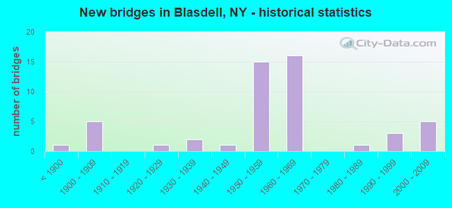
- New bridges - historical statistics
- 1Before 1900
- 51900-1909
- 11920-1929
- 21930-1939
- 11940-1949
- 151950-1959
- 161960-1969
- 11980-1989
- 31990-1999
- 52000-2009

- Reconstructed bridges - Historical Statistics
- 11980-1989
- 31990-1999


- Bridge Condition - Deck
- 15.0%Very good
- 35.0%Good
- 25.0%Satisfactory
- 20.0%Fair
- 5.0%Poor

- Bridge Condition - Superstructure
- 25.0%Very good
- 30.0%Good
- 30.0%Satisfactory
- 15.0%Fair

- Bridge Condition - Substructure
- 15.0%Very good
- 35.0%Good
- 20.0%Satisfactory
- 30.0%Fair

- Bridge Condition - Channel
- 23.1%Very good
- 46.2%Good
- 15.4%Satisfactory
- 15.4%Poor

- Bridge Condition - Culverts
- 28.6%Very good
- 14.3%Satisfactory
- 42.9%Fair
- 14.3%Poor
Find on map >> Show street view
Structure Number: 10014, Location: .4 MI NE JCT SH 5 & SH 75 (Lat: 42.777483, Lng: -78.857303), Route carried "on" structure: State highway 5, Year Built: 1962, Status: Open, Structure Length: 10.12m (33.20ft), Average Daily Traffic: 32,870 (year 2020), Truck Traffic: 5%, Average Future Daily Traffic: 33,024 (year 2040), Design Load: HS 25 or greater, Features Intersected: B LINE - S.H.75 S
Minimum Vertical Clearance: 30+ m (98+ ft), Kilometerpoint: 32.148, Lanes on structure: 2, Lanes under structure: 2, Base Highway Network: Yes, Owner: State Highway Agency, Approaching Roadway Width: 11.6m (38.1ft), Material/Design: Steel continuous, Design/Construction: Stringer/Multi-beam, Number Of Spans In Main Unit: 3, Length of Maximum Span: 48.1m (157.8ft), Curb-To-Curb Width: 8.5m (27.9ft), Out-to-Out Width: 10.1m (33.1ft)
Condition: Deck: Fair, Superstructure: Good, Substructure: Good, Operating Rating: 68.9 metric tons, Method Used To Determine Operating Rating: Load Factor (LF), Inventory Rating: 40.8 metric tons, Method Used To Determine Inventory Rating: Load Factor (LF), Structural Evaluation: Better than present minimum criteria, Deck Geometry: High priority of corrective action, Underclear: Meets minimum limits, Approach Roadway Alignment: Equal to present minimum criteria, Length Of Structure Improvement: 10.11m (33.17ft), Designated Inspection Frequency: Every 24 months, Inspection Date: November 2021, Bridge Improvement Cost: $3,632,000, Roadway Improvement Cost: $2,127,000, Total Project Cost: $5,758,000 ( Estimate for 2021), Deck Structure Type: Concrete Cast-file-Place, Wearing Surface/Protective System: Wearing Surface: Bituminous, Membrane: Preformed Fabric
Find on map >> Show street view
Structure Number: 1001429, Location: 0.2 MI S JCT RTS 5 & 179 (Lat: 42.788978, Lng: -78.847186), Route carried "on" structure: State highway 5, Year Built: 1962, Status: Open, Structure Length: 5.09m (16.70ft), Average Daily Traffic: 29,418 (year 2019), Truck Traffic: 6%, Average Future Daily Traffic: 29,556 (year 2040), Design Load: HS 20+Mod, Features Intersected: RTE 179
Minimum Vertical Clearance: 30+ m (98+ ft), Kilometerpoint: 33.821, Lanes on structure: 6, Lanes under structure: 2, Base Highway Network: Yes, Owner: State Highway Agency, Approaching Roadway Width: 35.7m (117.1ft), Skew: 20 degrees, Material/Design: Steel, Design/Construction: Stringer/Multi-beam, Number Of Spans In Main Unit: 3, Length of Maximum Span: 23.7m (77.8ft), Curb or Sidewalk Widths: Left: 0.9m (3.0ft), Right: 0.9m (3.0ft), Curb-To-Curb Width: 29.9m (98.1ft), Out-to-Out Width: 31.5m (103.3ft)
Condition: Deck: Good, Superstructure: Satisfactory, Substructure: Satisfactory, Operating Rating: 55.3 metric tons, Method Used To Determine Operating Rating: Load Factor (LF), Inventory Rating: 37.2 metric tons, Method Used To Determine Inventory Rating: Load Factor (LF), Structural Evaluation: Equal to present minimum criteria, Deck Geometry: Superior to present desirable criteria, Underclear: High priority of corrective action, Approach Roadway Alignment: Equal to present minimum criteria, Length Of Structure Improvement: 5.09m (16.70ft), Designated Inspection Frequency: Every 24 months, Inspection Date: September 2020, Bridge Improvement Cost: $5,897,000, Roadway Improvement Cost: $3,453,000, Total Project Cost: $9,350,000 ( Estimate for 2021), Deck Structure Type: Concrete Cast-file-Place, Wearing Surface/Protective System: Wearing Surface: Integral Concrete
Find on map >> Show street view
Structure Number: 1001439, Location: JCT RTS 5 & 179 (Lat: 42.791264, Lng: -78.847019), Route carried "on" structure: State highway 5, Year Built: 1962, Status: Open, Structure Length: 5.15m (16.90ft), Average Daily Traffic: 29,418 (year 2019), Truck Traffic: 6%, Average Future Daily Traffic: 29,556 (year 2040), Design Load: HS 20+Mod, Features Intersected: RTE 179
Minimum Vertical Clearance: 30+ m (98+ ft), Kilometerpoint: 34.079, Lanes on structure: 6, Lanes under structure: 2, Base Highway Network: Yes, Owner: State Highway Agency, Approaching Roadway Width: 26.2m (86.0ft), Skew: 20 degrees, Material/Design: Steel, Design/Construction: Stringer/Multi-beam, Number Of Spans In Main Unit: 3, Length of Maximum Span: 24.0m (78.7ft), Curb or Sidewalk Widths: Left: 0.9m (3.0ft), Right: 0.9m (3.0ft), Curb-To-Curb Width: 29.9m (98.1ft), Out-to-Out Width: 31.5m (103.3ft)
Condition: Deck: Good, Superstructure: Satisfactory, Substructure: Good, Operating Rating: 38.9 metric tons, Method Used To Determine Operating Rating: Load and Resistance Factor Rating (LRFR) rating reported by rating factor(RF) method using HL-93 loadings, Inventory Rating: 30.1 metric tons, Method Used To Determine Inventory Rating: Load and Resistance Factor Rating (LRFR) rating reported by rating factor(RF) method using HL-93 loadings, Structural Evaluation: Equal to present minimum criteria, Deck Geometry: Superior to present desirable criteria, Underclear: High priority of corrective action, Approach Roadway Alignment: Equal to present minimum criteria, Length Of Structure Improvement: 5.15m (16.90ft), Designated Inspection Frequency: Every 24 months, Inspection Date: July 2020, Bridge Improvement Cost: $5,959,000, Roadway Improvement Cost: $3,489,000, Total Project Cost: $9,448,000 ( Estimate for 2021), Deck Structure Type: Concrete Cast-file-Place, Wearing Surface/Protective System: Wearing Surface: Integral Concrete
Find on map >> Show street view
Structure Number: 1001449, Location: 0.2 MI N JCT RTS 5 & 179 (Lat: 42.793486, Lng: -78.846889), Route carried "on" structure: State highway 5, Year Built: 1962, Status: Open, Structure Length: 0.91m (2.99ft), Average Daily Traffic: 29,418 (year 2019), Truck Traffic: 6%, Average Future Daily Traffic: 29,556 (year 2040), Design Load: HS 20+Mod, Features Intersected: RUSH CREEK
Minimum Vertical Clearance: 30+ m (98+ ft), Kilometerpoint: 34.336, Lanes on structure: 6, Base Highway Network: Yes, Owner: State Highway Agency, Approaching Roadway Width: 30.5m (100.1ft), Skew: 20 degrees, Material/Design: Concrete continuous, Design/Construction: Culvert, Number Of Spans In Main Unit: 2, Length of Maximum Span: 4.2m (13.8ft), Curb or Sidewalk Widths: Left: 1.5m (4.9ft), Right: 1.5m (4.9ft)
Condition: Channel: Good, Culverts: Fair, Operating Rating: 75.6 metric tons, Method Used To Determine Operating Rating: Field evaluation and documented engineering judgment, Inventory Rating: 32.7 metric tons, Method Used To Determine Inventory Rating: Field evaluation and documented engineering judgment, Structural Evaluation: Somewhat better than minimum adequacy, Waterway Adequacy: Meets minimum limits, Approach Roadway Alignment: Equal to present minimum criteria, Length Of Structure Improvement: 0.91m (2.99ft), Designated Inspection Frequency: Every 24 months, Inspection Date: June 2020, Bridge Improvement Cost: $770,000, Roadway Improvement Cost: $451,000, Total Project Cost: $1,221,000 ( Estimate for 2021), Wearing Surface/Protective System: Wearing Surface: Bituminous
Find on map >> Show street view
Structure Number: 101546, Location: 0.3 MI NE JCT RTS 20 + 62 (Lat: 42.765536, Lng: -78.820558), Route carried "on" structure: US 20, Year Built: 2009, Status: Open, Structure Length: 1.34m (4.40ft), Average Daily Traffic: 19,431 (year 2019), Truck Traffic: 3%, Average Future Daily Traffic: 19,522 (year 2040), Design Load: HS 25 or greater, Features Intersected: BUFFALO SOUTHERN
Minimum Vertical Clearance: 30+ m (98+ ft), Kilometerpoint: 32.325, Lanes on structure: 4, Base Highway Network: Yes, Owner: State Highway Agency, Approaching Roadway Width: 18.0m (59.1ft), Material/Design: Concrete, Design/Construction: Frame, Number Of Spans In Main Unit: 1, Length of Maximum Span: 12.2m (40.0ft), Curb or Sidewalk Widths: Left: 1.9m (6.2ft), Right: 3.4m (11.2ft), Curb-To-Curb Width: 18.0m (59.1ft), Out-to-Out Width: 23.6m (77.4ft)
Condition: Deck: Good, Superstructure: Good, Substructure: Good, Operating Rating: 81.3 metric tons, Method Used To Determine Operating Rating: Field evaluation and documented engineering judgment, Inventory Rating: 40.8 metric tons, Method Used To Determine Inventory Rating: Field evaluation and documented engineering judgment, Structural Evaluation: Better than present minimum criteria, Deck Geometry: Somewhat better than minimum adequacy, Underclear: Better than present minimum criteria, Approach Roadway Alignment: Equal to present desirable criteria, Length Of Structure Improvement: 1.34m (4.40ft), Designated Inspection Frequency: Every 24 months, Inspection Date: November 2021, Bridge Improvement Cost: $2,143,000, Roadway Improvement Cost: $1,255,000, Total Project Cost: $3,398,000 ( Estimate for 2021), Deck Structure Type: Concrete Cast-file-Place, Wearing Surface/Protective System: Wearing Surface: Bituminous, Membrane: Other, Deck Protection: Epoxy Coated Reinforcing
Find on map >> Show street view
Structure Number: 101548, Location: JCT RTS 20 +I-90 (Lat: 42.767058, Lng: -78.817489), Route carried "on" structure: US 20, Year Built: 2009, Status: Open, Structure Length: 1.07m (3.51ft), Average Daily Traffic: 19,431 (year 2019), Truck Traffic: 3%, Average Future Daily Traffic: 19,522 (year 2040), Design Load: HS 25 or greater, Features Intersected: 90I (EB), RUSH CREEK
Minimum Vertical Clearance: 4.62m (15.16ft), Kilometerpoint: 32.614, Lanes on structure: 4, Base Highway Network: Yes, Owner: State Highway Agency, Approaching Roadway Width: 15.8m (51.8ft), Material/Design: Concrete, Design/Construction: Culvert, Number Of Spans In Main Unit: 2, Length of Maximum Span: 4.9m (16.1ft), Curb or Sidewalk Widths: Left: 2.0m (6.6ft), Right: 2.0m (6.6ft), Curb-To-Curb Width: 15.6m (51.2ft), Out-to-Out Width: 23.4m (76.8ft)
Condition: Channel: Good, Culverts: Very good, Operating Rating: 72.6 metric tons, Method Used To Determine Operating Rating: Load Factor (LF), Inventory Rating: 43.5 metric tons, Method Used To Determine Inventory Rating: Load Factor (LF), Structural Evaluation: Equal to present desirable criteria, Deck Geometry: Meets minimum limits, Waterway Adequacy: Equal to present minimum criteria, Approach Roadway Alignment: Equal to present desirable criteria, Length Of Structure Improvement: 1.06m (3.48ft), Designated Inspection Frequency: Every 24 months, Inspection Date: April 2021, Bridge Improvement Cost: $690,000, Roadway Improvement Cost: $404,000, Total Project Cost: $1,094,000 ( Estimate for 2021), Wearing Surface/Protective System: Wearing Surface: Bituminous, Membrane: Other
Find on map >> Show street view
Structure Number: 102823, Location: JCT RT 62 + I-90 (Lat: 42.759967, Lng: -78.824397), Route carried "on" structure: US 62, Year Built: 1956, Status: Open, Structure Length: 11.03m (36.19ft), Average Daily Traffic: 11,190 (year 2020), Truck Traffic: 3%, Average Future Daily Traffic: 11,242 (year 2040), Design Load: HS 20+Mod, Features Intersected: 90 IX EB, RTE I90
Minimum Vertical Clearance: 30+ m (98+ ft), Kilometerpoint: 37.586, Lanes on structure: 4, Lanes under structure: 4, Base Highway Network: Yes, Owner: State Toll Authority, Approaching Roadway Width: 20.1m (65.9ft), Skew: 24 degrees, Material/Design: Steel continuous, Design/Construction: Stringer/Multi-beam, Number Of Spans In Main Unit: 5, Length of Maximum Span: 27.4m (89.9ft), Curb or Sidewalk Widths: Left: 0.8m (2.6ft), Right: 0.8m (2.6ft), Curb-To-Curb Width: 18.9m (62.0ft), Out-to-Out Width: 21.0m (68.9ft)
Condition: Deck: Poor, Superstructure: Good, Substructure: Fair, Operating Rating: 45.7 metric tons, Method Used To Determine Operating Rating: Load and Resistance Factor Rating (LRFR) rating reported by rating factor(RF) method using HL-93 loadings, Inventory Rating: 35.0 metric tons, Method Used To Determine Inventory Rating: Load and Resistance Factor Rating (LRFR) rating reported by rating factor(RF) method using HL-93 loadings, Structural Evaluation: Somewhat better than minimum adequacy, Deck Geometry: Equal to present minimum criteria, Underclear: High priority of corrective action, Approach Roadway Alignment: Equal to present minimum criteria, Length Of Structure Improvement: 11.03m (36.19ft), Designated Inspection Frequency: Every 24 months, Inspection Date: August 2020, Bridge Improvement Cost: $8,130,000, Roadway Improvement Cost: $4,761,000, Total Project Cost: $12,891,000 ( Estimate for 2021), Deck Structure Type: Concrete Cast-file-Place, Wearing Surface/Protective System: Wearing Surface: Bituminous
Find on map >> Show street view
Structure Number: 102825, Location: 1 MI N JCT US 62 & SH 179 (Lat: 42.802928, Lng: -78.823964), Route carried "on" structure: US 62, Year Built: 1987, Status: Open, Structure Length: 4.48m (14.70ft), Average Daily Traffic: 10,828 (year 2019), Truck Traffic: 4%, Average Future Daily Traffic: 10,878 (year 2040), Design Load: HS 20, Features Intersected: NORFOLK SOUTHERN
Minimum Vertical Clearance: 30+ m (98+ ft), Kilometerpoint: 42.381, Lanes on structure: 2, Base Highway Network: Yes, Owner: State Highway Agency, Approaching Roadway Width: 15.8m (51.8ft), Skew: 22 degrees, Material/Design: Prestressed concrete continuous, Design/Construction: Box Beam or Girders - Multiple, Number Of Spans In Main Unit: 3, Length of Maximum Span: 18.2m (59.7ft), Curb or Sidewalk Widths: Left: 1.5m (4.9ft), Right: 1.5m (4.9ft), Curb-To-Curb Width: 15.8m (51.8ft), Out-to-Out Width: 19.4m (63.6ft)
Condition: Deck: Satisfactory, Superstructure: Very good, Substructure: Good, Operating Rating: 68.9 metric tons, Method Used To Determine Operating Rating: Load Factor (LF), Inventory Rating: 27.2 metric tons, Method Used To Determine Inventory Rating: Load Factor (LF), Structural Evaluation: Equal to present minimum criteria, Deck Geometry: Superior to present desirable criteria, Underclear: Somewhat better than minimum adequacy, Approach Roadway Alignment: Equal to present desirable criteria, Length Of Structure Improvement: 4.48m (14.70ft), Designated Inspection Frequency: Every 24 months, Inspection Date: July 2020, Bridge Improvement Cost: $2,270,000, Roadway Improvement Cost: $1,330,000, Total Project Cost: $3,600,000 ( Estimate for 2021), Deck Structure Type: Concrete Cast-file-Place, Wearing Surface/Protective System: Wearing Surface: Integral Concrete, Deck Protection: Epoxy Coated Reinforcing
Find on map >> Show street view
Structure Number: 1039449, Location: 0.9 MI E JCT RTS 179 + 5 (Lat: 42.789797, Lng: -78.836533), Route carried "on" structure: State highway 179, Year Built: 1966, Year Reconstructed: 2001, Status: Open, Structure Length: 27.37m (89.80ft), Average Daily Traffic: 19,307 (year 2020), Truck Traffic: 10%, Average Future Daily Traffic: 19,397 (year 2040), Features Intersected: JEFFERY BLVD, FORD CO AC
Minimum Vertical Clearance: 30+ m (98+ ft), Kilometerpoint: 0.628, Lanes on structure: 4, Lanes under structure: 4, Base Highway Network: Yes, Owner: State Highway Agency, Approaching Roadway Width: 18.3m (60.0ft), Skew: 20 degrees, Material/Design: Steel continuous, Design/Construction: Stringer/Multi-beam, Number Of Spans In Main Unit: 8, Length of Maximum Span: 37.0m (121.4ft), Curb-To-Curb Width: 18.3m (60.0ft), Out-to-Out Width: 19.9m (65.3ft)
Condition: Deck: Good, Superstructure: Very good, Substructure: Satisfactory, Channel: Good, Operating Rating: 30.5 metric tons, Method Used To Determine Operating Rating: Load and Resistance Factor Rating (LRFR) rating reported by rating factor(RF) method using HL-93 loadings, Inventory Rating: 23.7 metric tons, Method Used To Determine Inventory Rating: Load and Resistance Factor Rating (LRFR) rating reported by rating factor(RF) method using HL-93 loadings, Structural Evaluation: Somewhat better than minimum adequacy, Deck Geometry: Somewhat better than minimum adequacy, Underclear: Equal to present minimum criteria, Waterway Adequacy: Somewhat better than minimum adequacy, Approach Roadway Alignment: Equal to present desirable criteria, Length Of Structure Improvement: 27.37m (89.80ft), Designated Inspection Frequency: Every 24 months, Inspection Date: September 2021, Bridge Improvement Cost: $18,150,000, Roadway Improvement Cost: $10,629,000, Total Project Cost: $28,779,000 ( Estimate for 2021), Deck Structure Type: Concrete Cast-file-Place, Wearing Surface/Protective System: Wearing Surface: Monolithic Concrete, Deck Protection: Epoxy Coated Reinforcing
Find on map >> Show street view
Structure Number: 103946, Location: 0.3 MI W JCT RTS 179 + 62 (Lat: 42.789144, Lng: -78.829075), Route carried "on" structure: Other road , Year Built: 1966, Status: Open, Structure Length: 4.60m (15.09ft), Average Daily Traffic: 268 (year 2020), Truck Traffic: 4%, Average Future Daily Traffic: 375 (year 2040), Design Load: HS 20, Features Intersected: 179 179 53011009, RTE 17, Facility Carried by Structure: ELECTRIC AVE.
Minimum Vertical Clearance: 30+ m (98+ ft), Kilometerpoint: 0.080, Lanes on structure: 2, Lanes under structure: 4, Owner: State Highway Agency, Approaching Roadway Width: 9.1m (29.9ft), Material/Design: Steel, Design/Construction: Stringer/Multi-beam, Number Of Spans In Main Unit: 2, Length of Maximum Span: 22.2m (72.8ft), Curb or Sidewalk Widths: Left: 1.5m (4.9ft), Right: 1.5m (4.9ft), Curb-To-Curb Width: 9.1m (29.9ft), Out-to-Out Width: 12.7m (41.7ft)
Condition: Deck: Good, Superstructure: Good, Substructure: Good, Operating Rating: 73.9 metric tons, Method Used To Determine Operating Rating: Load and Resistance Factor Rating (LRFR) rating reported by rating factor(RF) method using HL-93 loadings, Inventory Rating: 56.7 metric tons, Method Used To Determine Inventory Rating: Load and Resistance Factor Rating (LRFR) rating reported by rating factor(RF) method using HL-93 loadings, Structural Evaluation: Better than present minimum criteria, Deck Geometry: Equal to present minimum criteria, Underclear: Meets minimum limits, Approach Roadway Alignment: Equal to present minimum criteria, Length Of Structure Improvement: 4.60m (15.09ft), Designated Inspection Frequency: Every 24 months, Inspection Date: June 2020, Bridge Improvement Cost: $2,136,000, Roadway Improvement Cost: $1,251,000, Total Project Cost: $3,387,000 ( Estimate for 2021), Deck Structure Type: Concrete Cast-file-Place, Wearing Surface/Protective System: Wearing Surface: Bituminous
Find on map >> Show street view
Structure Number: 105065, Location: 0.6 MI W JCT RTS 20A + 20 (Lat: 42.771589, Lng: -78.821947), Route carried "on" structure: Alternate State highway 951E, Year Built: 1948, Status: Open, Structure Length: 0.91m (2.99ft), Average Daily Traffic: 4,641 (year 2018), Truck Traffic: 3%, Average Future Daily Traffic: 4,900 (year 2040), Features Intersected: RUSH CREEK
Minimum Vertical Clearance: 30+ m (98+ ft), Kilometerpoint: 0.145, Lanes on structure: 2, Base Highway Network: Yes, Owner: State Highway Agency, Approaching Roadway Width: 13.7m (44.9ft), Skew: 3 degrees, Material/Design: Concrete, Design/Construction: Slab, Number Of Spans In Main Unit: 1, Length of Maximum Span: 8.2m (26.9ft), Curb-To-Curb Width: 12.8m (42.0ft), Out-to-Out Width: 13.7m (44.9ft)
Condition: Deck: Very good, Superstructure: Very good, Substructure: Very good, Channel: Very good, Operating Rating: 54.4 metric tons, Method Used To Determine Operating Rating: Load Factor (LF), Inventory Rating: 32.7 metric tons, Method Used To Determine Inventory Rating: Load Factor (LF), Structural Evaluation: Equal to present desirable criteria, Deck Geometry: Equal to present minimum criteria, Waterway Adequacy: Somewhat better than minimum adequacy, Approach Roadway Alignment: Equal to present minimum criteria, Length Of Structure Improvement: 0.91m (2.99ft), Designated Inspection Frequency: Every 24 months, Inspection Date: May 2020, Bridge Improvement Cost: $700,000, Roadway Improvement Cost: $410,000, Total Project Cost: $1,109,000 ( Estimate for 2021), Wearing Surface/Protective System: Wearing Surface: Bituminous
Find on map >> Show street view
Structure Number: 105066, Location: 0.3 MI W JCT RTS 20A + 20 (Lat: 42.770783, Lng: -78.816636), Route carried "on" structure: State highway 951E, Year Built: 1958, Status: Open, Structure Length: 8.75m (28.71ft), Average Daily Traffic: 4,641 (year 2018), Truck Traffic: 3%, Average Future Daily Traffic: 4,900 (year 2040), Design Load: HS 20+Mod, Features Intersected: RTE I90
Minimum Vertical Clearance: 30+ m (98+ ft), Kilometerpoint: 0.531, Lanes on structure: 2, Lanes under structure: 4, Base Highway Network: Yes, Owner: State Toll Authority, Approaching Roadway Width: 14.0m (45.9ft), Material/Design: Steel, Design/Construction: Stringer/Multi-beam, Number Of Spans In Main Unit: 5, Length of Maximum Span: 20.4m (66.9ft), Curb or Sidewalk Widths: Left: 1.5m (4.9ft), Right: 1.5m (4.9ft), Curb-To-Curb Width: 11.0m (36.1ft), Out-to-Out Width: 14.6m (47.9ft)
Condition: Deck: Fair, Superstructure: Satisfactory, Substructure: Fair, Operating Rating: 61.7 metric tons, Method Used To Determine Operating Rating: Load Factor (LF), Inventory Rating: 36.3 metric tons, Method Used To Determine Inventory Rating: Load Factor (LF), Structural Evaluation: Somewhat better than minimum adequacy, Deck Geometry: Somewhat better than minimum adequacy, Underclear: High priority of corrective action, Approach Roadway Alignment: Equal to present minimum criteria, Length Of Structure Improvement: 8.74m (28.67ft), Designated Inspection Frequency: Every 24 months, Inspection Date: September 2020, Bridge Improvement Cost: $4,519,000, Roadway Improvement Cost: $2,647,000, Total Project Cost: $7,166,000 ( Estimate for 2021), Deck Structure Type: Concrete Cast-file-Place, Wearing Surface/Protective System: Wearing Surface: Bituminous, Membrane: Other
Find on map >> Show street view
Structure Number: 106303, Location: 0.3 MI NE JCT RTS 5 + 75 (Lat: 42.777194, Lng: -78.859283), Route carried "on" structure: State highway 5, Year Built: 1962, Status: Open, Structure Length: 0.73m (2.40ft), Average Daily Traffic: 17,446 (year 2020), Truck Traffic: 4%, Average Future Daily Traffic: 17,527 (year 2040), Features Intersected: FOSTER BROOK
Minimum Vertical Clearance: 30+ m (98+ ft), Kilometerpoint: 32.083, Lanes on structure: 2, Base Highway Network: Yes, Owner: State Highway Agency, Approaching Roadway Width: 12.2m (40.0ft), Skew: 1 degrees, Material/Design: Steel, Design/Construction: Culvert, Number Of Spans In Main Unit: 2, Length of Maximum Span: 3.0m (9.8ft)
Condition: Channel: Good, Culverts: Fair, Operating Rating: 74.8 metric tons, Method Used To Determine Operating Rating: Field evaluation and documented engineering judgment, Inventory Rating: 32.7 metric tons, Method Used To Determine Inventory Rating: Field evaluation and documented engineering judgment, Structural Evaluation: Somewhat better than minimum adequacy, Waterway Adequacy: Somewhat better than minimum adequacy, Approach Roadway Alignment: Better than present minimum criteria, Length Of Structure Improvement: 0.73m (2.40ft), Designated Inspection Frequency: Every 24 months, Inspection Date: July 2021, Bridge Improvement Cost: $246,000, Roadway Improvement Cost: $144,000, Total Project Cost: $391,000 ( Estimate for 2021), Wearing Surface/Protective System: Wearing Surface: Bituminous
Find on map >> Show street view
Structure Number: 106304, Location: 0.3 MI NE JCT RTS 5 + 75 (Lat: 42.776867, Lng: -78.858972), Route carried "on" structure: State highway 5, Year Built: 1962, Status: Open, Structure Length: 0.73m (2.40ft), Average Daily Traffic: 17,446 (year 2020), Truck Traffic: 4%, Average Future Daily Traffic: 17,527 (year 2040), Features Intersected: FOSTER BROOK
Minimum Vertical Clearance: 30+ m (98+ ft), Kilometerpoint: 32.083, Lanes on structure: 2, Base Highway Network: Yes, Owner: State Highway Agency, Approaching Roadway Width: 12.2m (40.0ft), Material/Design: Steel, Design/Construction: Culvert, Number Of Spans In Main Unit: 2, Length of Maximum Span: 3.0m (9.8ft)
Condition: Channel: Good, Culverts: Poor, Operating Rating: 74.5 metric tons, Method Used To Determine Operating Rating: Field evaluation and documented engineering judgment, Inventory Rating: 29.4 metric tons, Method Used To Determine Inventory Rating: Field evaluation and documented engineering judgment, Structural Evaluation: Meets minimum limits, Waterway Adequacy: Meets minimum limits, Approach Roadway Alignment: Equal to present minimum criteria, Length Of Structure Improvement: 0.73m (2.40ft), Designated Inspection Frequency: Every 24 months, Inspection Date: July 2021, Bridge Improvement Cost: $246,000, Roadway Improvement Cost: $144,000, Total Project Cost: $391,000 ( Estimate for 2021)
Find on map >> Show street view
Structure Number: 106305, Location: 0.3 MI NE JCT RTS 5 + 75 (Lat: 42.775997, Lng: -78.858617), Route carried "on" structure: Ramp State highway 75, Year Built: 2002, Status: Open, Structure Length: 1.10m (3.61ft), Average Daily Traffic: 15,827 (year 2020), Truck Traffic: 6%, Average Future Daily Traffic: 15,901 (year 2040), Design Load: HS 25 or greater, Features Intersected: FOSTER BROOK
Minimum Vertical Clearance: 30+ m (98+ ft), Kilometerpoint: 33.725, Lanes on structure: 3, Base Highway Network: Yes, Owner: State Highway Agency, Approaching Roadway Width: 15.5m (50.9ft), Skew: 4 degrees, Material/Design: Concrete, Design/Construction: Frame, Number Of Spans In Main Unit: 1, Length of Maximum Span: 10.2m (33.5ft), Curb-To-Curb Width: 16.3m (53.5ft), Out-to-Out Width: 20.4m (66.9ft)
Condition: Deck: Very good, Superstructure: Very good, Substructure: Very good, Channel: Good, Operating Rating: 79.8 metric tons, Method Used To Determine Operating Rating: Load Factor (LF), Inventory Rating: 47.2 metric tons, Method Used To Determine Inventory Rating: Load Factor (LF), Structural Evaluation: Equal to present desirable criteria, Deck Geometry: Superior to present desirable criteria, Waterway Adequacy: Equal to present desirable criteria, Approach Roadway Alignment: Equal to present desirable criteria, Length Of Structure Improvement: 1.09m (3.58ft), Designated Inspection Frequency: Every 24 months, Inspection Date: October 2020, Bridge Improvement Cost: $910,000, Roadway Improvement Cost: $533,000, Total Project Cost: $1,442,000 ( Estimate for 2021), Wearing Surface/Protective System: Wearing Surface: Bituminous, Membrane: Other
Find on map >> Show street view
Structure Number: 106306, Location: 0.3M NE JCT RTS 5 & 75 (Lat: 42.775203, Lng: -78.858267), Route carried "on" structure: Ramp State highway 75, Year Built: 1994, Status: Open, Structure Length: 0.70m (2.30ft), Average Daily Traffic: 15,827 (year 2020), Truck Traffic: 6%, Average Future Daily Traffic: 15,901 (year 2040), Design Load: HS 25 or greater, Features Intersected: FOSTER BROOK
Minimum Vertical Clearance: 30+ m (98+ ft), Kilometerpoint: 33.725, Lanes on structure: 2, Base Highway Network: Yes, Owner: State Highway Agency, Approaching Roadway Width: 11.9m (39.0ft), Skew: 3 degrees, Material/Design: Concrete, Design/Construction: Culvert, Number Of Spans In Main Unit: 1, Length of Maximum Span: 6.7m (22.0ft), Curb-To-Curb Width: 11.9m (39.0ft), Out-to-Out Width: 12.8m (42.0ft)
Condition: Channel: Very good, Culverts: Very good, Operating Rating: 59.9 metric tons, Method Used To Determine Operating Rating: Load Factor (LF), Inventory Rating: 40.8 metric tons, Method Used To Determine Inventory Rating: Load Factor (LF), Structural Evaluation: Equal to present desirable criteria, Deck Geometry: Superior to present desirable criteria, Waterway Adequacy: Equal to present minimum criteria, Approach Roadway Alignment: Equal to present desirable criteria, Length Of Structure Improvement: 0.70m (2.30ft), Designated Inspection Frequency: Every 24 months, Inspection Date: July 2021, Bridge Improvement Cost: $248,000, Roadway Improvement Cost: $145,000, Total Project Cost: $393,000 ( Estimate for 2021), Wearing Surface/Protective System: Wearing Surface: Bituminous, Membrane: Other
Find on map >> Show street view
Structure Number: 226083, Location: 0.8 MI SW OF BLASDELL (Lat: 42.788542, Lng: -78.834583), Route carried "on" structure: ServiceOther road , Year Built: 1992, Status: Open, Structure Length: 1.74m (5.71ft), Average Daily Traffic: 2,249 (year 2017), Truck Traffic: 4%, Average Future Daily Traffic: 3,149 (year 2037), Design Load: HS 20, Features Intersected: RUSH CREEK, Facility Carried by Structure: JEFFREY BOULEVARD
Minimum Vertical Clearance: 30+ m (98+ ft), Kilometerpoint: 1.802, Lanes on structure: 2, Owner: Town or Township Highway Agency, Approaching Roadway Width: 7.3m (24.0ft), Skew: 3 degrees, Material/Design: Concrete, Design/Construction: Frame, Number Of Spans In Main Unit: 2, Length of Maximum Span: 8.2m (26.9ft), Curb or Sidewalk Widths: Left: 0.4m (1.3ft), Right: 1.2m (3.9ft), Curb-To-Curb Width: 8.2m (26.9ft), Out-to-Out Width: 10.7m (35.1ft)
Condition: Deck: Good, Superstructure: Good, Substructure: Good, Channel: Poor, Operating Rating: 78.4 metric tons, Method Used To Determine Operating Rating: Field evaluation and documented engineering judgment, Inventory Rating: 32.7 metric tons, Method Used To Determine Inventory Rating: Field evaluation and documented engineering judgment, Structural Evaluation: Better than present minimum criteria, Deck Geometry: High priority of corrective action, Waterway Adequacy: Meets minimum limits, Approach Roadway Alignment: Equal to present desirable criteria, Length Of Structure Improvement: 1.73m (5.68ft), Designated Inspection Frequency: Every 24 months, Inspection Date: June 2020, Bridge Improvement Cost: $491,000, Roadway Improvement Cost: $287,000, Total Project Cost: $778,000 ( Estimate for 2021), Wearing Surface/Protective System: Wearing Surface: Bituminous, Membrane: Other
Find on map >> Show street view
Structure Number: 332757, Location: 0,5 MI SOUTH OF ROUTE 20 (Lat: 42.762022, Lng: -78.811822), Route carried "on" structure: County highway , Year Built: 1994, Status: Open, Structure Length: 1.28m (4.20ft), Average Daily Traffic: 6,047 (year 2020), Truck Traffic: 3%, Average Future Daily Traffic: 6,385 (year 2040), Design Load: HS 25 or greater, Features Intersected: RUSH CREEK, Facility Carried by Structure: MCKINLEY PARKWAY
Minimum Vertical Clearance: 30+ m (98+ ft), Kilometerpoint: 5.310, Lanes on structure: 4, Owner: County Highway Agency, Approaching Roadway Width: 17.7m (58.1ft), Skew: 24 degrees, Material/Design: Concrete, Design/Construction: Culvert, Number Of Spans In Main Unit: 2, Length of Maximum Span: 6.0m (19.7ft)
Condition: Channel: Poor, Culverts: Fair, Operating Rating: 97.2 metric tons, Method Used To Determine Operating Rating: Load and Resistance Factor Rating (LRFR) rating reported by rating factor(RF) method using HL-93 loadings, Inventory Rating: 81.0 metric tons, Method Used To Determine Inventory Rating: Load and Resistance Factor Rating (LRFR) rating reported by rating factor(RF) method using HL-93 loadings, Structural Evaluation: Somewhat better than minimum adequacy, Waterway Adequacy: Equal to present minimum criteria, Approach Roadway Alignment: Equal to present desirable criteria, Length Of Structure Improvement: 1.28m (4.20ft), Designated Inspection Frequency: Every 24 months, Inspection Date: April 2021, Bridge Improvement Cost: $625,000, Roadway Improvement Cost: $366,000, Total Project Cost: $991,000 ( Estimate for 2021), Wearing Surface/Protective System: Wearing Surface: Bituminous, Membrane: Other
Find on map >> Show street view
Structure Number: 332771, Location: .75 MI. SE OF WOODLAWN (Lat: 42.790247, Lng: -78.837031), Route carried "on" structure: Other road , Year Built: 1923, Status: Open, Structure Length: 1.04m (3.41ft), Average Daily Traffic: 89 (year 2016), Truck Traffic: 9%, Average Future Daily Traffic: 125 (year 2036), Features Intersected: RUSH CREEK, Facility Carried by Structure: MAPLE AVENUE
Minimum Vertical Clearance: 30+ m (98+ ft), Kilometerpoint: 0.000, Lanes on structure: 2, Owner: Town or Township Highway Agency, Approaching Roadway Width: 5.5m (18.0ft), Material/Design: Steel, Design/Construction: Stringer/Multi-beam, Number Of Spans In Main Unit: 1, Length of Maximum Span: 9.7m (31.8ft), Curb-To-Curb Width: 6.4m (21.0ft), Out-to-Out Width: 7.3m (24.0ft)
Condition: Deck: Good, Superstructure: Good, Substructure: Good, Channel: Satisfactory, Operating Rating: 46.5 metric tons, Method Used To Determine Operating Rating: Field evaluation and documented engineering judgment, Inventory Rating: 20.9 metric tons, Method Used To Determine Inventory Rating: Field evaluation and documented engineering judgment, Structural Evaluation: Equal to present minimum criteria, Deck Geometry: Somewhat better than minimum adequacy, Waterway Adequacy: Better than present minimum criteria, Approach Roadway Alignment: Meets minimum limits, Length Of Structure Improvement: 1.03m (3.38ft), Designated Inspection Frequency: Every 24 months, Inspection Date: June 2020, Bridge Improvement Cost: $502,000, Roadway Improvement Cost: $294,000, Total Project Cost: $796,000 ( Estimate for 2021), Deck Structure Type: Concrete Cast-file-Place, Wearing Surface/Protective System: Wearing Surface: Bituminous
Find on map >> Show street view
Structure Number: 5015471, Location: JCT US 20 & I90 (Lat: 42.766678, Lng: -78.818283), Route carried "on" structure: Interstate 90, Year Built: 1957, Year Reconstructed: 2003, Status: Open, Structure Length: 7.80m (25.59ft), Average Daily Traffic: 18,160 (year 2014), Truck Traffic: 19%, Features Intersected: RTE 20
Minimum Vertical Clearance: 30+ m (98+ ft), Kilometerpoint: 698.805, Lanes on structure: 2, Lanes under structure: 4, Base Highway Network: Yes, Toll: On Interstate toll segment, Owner: State Toll Authority, Approaching Roadway Width: 12.2m (40.0ft), Skew: 5 degrees, Material/Design: Steel, Design/Construction: Stringer/Multi-beam, Number Of Spans In Main Unit: 3, Length of Maximum Span: 36.9m (121.1ft), Curb-To-Curb Width: 15.8m (51.8ft), Out-to-Out Width: 17.1m (56.1ft)
Condition: Deck: Fair, Superstructure: Fair, Substructure: Fair, Operating Rating: 78.0 metric tons, Method Used To Determine Operating Rating: Load Factor (LF), Inventory Rating: 46.3 metric tons, Method Used To Determine Inventory Rating: Load Factor (LF), Structural Evaluation: Somewhat better than minimum adequacy, Deck Geometry: Superior to present desirable criteria, Underclear: Meets minimum limits, Approach Roadway Alignment: Equal to present desirable criteria, Length Of Structure Improvement: 7.80m (25.59ft), Designated Inspection Frequency: Every 24 months, Inspection Date: June 2021, Bridge Improvement Cost: $5,731,000, Roadway Improvement Cost: $3,356,000, Total Project Cost: $9,087,000 ( Estimate for 2021), Deck Structure Type: Concrete Cast-file-Place, Wearing Surface/Protective System: Wearing Surface: Monolithic Concrete
Find on map >> Show street view
Structure Number: 5015472, Location: JCT US 20 & I90 (Lat: 42.766994, Lng: -78.817653), Route carried "on" structure: Interstate 90, Year Built: 1957, Year Reconstructed: 2003, Status: Open, Structure Length: 7.80m (25.59ft), Average Daily Traffic: 11,677 (year 2017), Truck Traffic: 26%, Average Future Daily Traffic: 13,086 (year 2040), Features Intersected: RTE 20, RUSH CREEK
Minimum Vertical Clearance: 30+ m (98+ ft), Kilometerpoint: 32.470, Lanes on structure: 2, Lanes under structure: 4, Base Highway Network: Yes, Toll: On Interstate toll segment, Owner: State Toll Authority, Approaching Roadway Width: 11.6m (38.1ft), Skew: 5 degrees, Material/Design: Steel, Design/Construction: Stringer/Multi-beam, Number Of Spans In Main Unit: 3, Length of Maximum Span: 35.1m (115.2ft), Curb-To-Curb Width: 15.7m (51.5ft), Out-to-Out Width: 17.1m (56.1ft)
Condition: Deck: Fair, Superstructure: Fair, Substructure: Fair, Channel: Very good, Operating Rating: 67.1 metric tons, Method Used To Determine Operating Rating: Load Factor (LF), Inventory Rating: 39.9 metric tons, Method Used To Determine Inventory Rating: Load Factor (LF), Structural Evaluation: Somewhat better than minimum adequacy, Deck Geometry: Superior to present desirable criteria, Underclear: Meets minimum limits, Waterway Adequacy: Superior to present desirable criteria, Approach Roadway Alignment: Equal to present desirable criteria, Length Of Structure Improvement: 7.80m (25.59ft), Designated Inspection Frequency: Every 24 months, Inspection Date: June 2021, Bridge Improvement Cost: $5,508,000, Roadway Improvement Cost: $3,226,000, Total Project Cost: $8,734,000 ( Estimate for 2021), Deck Structure Type: Concrete Cast-file-Place, Wearing Surface/Protective System: Wearing Surface: Monolithic Concrete
Find on map >> Show street view
Structure Number: 5512481, Location: 1.7 MI NE OF INT 57 (Lat: 42.764539, Lng: -78.819600), Route carried "on" structure: Interstate 90, Year Built: 1957, Status: Open, Structure Length: 1.10m (3.61ft), Average Daily Traffic: 18,160 (year 2014), Truck Traffic: 19%, Design Load: HS 20, Features Intersected: BUFFALO SOUTHERN RR
Minimum Vertical Clearance: 30+ m (98+ ft), Kilometerpoint: 699.094, Lanes on structure: 2, Base Highway Network: Yes, Toll: On Interstate toll segment, Owner: State Toll Authority, Approaching Roadway Width: 11.6m (38.1ft), Skew: 2 degrees, Material/Design: Steel, Design/Construction: Stringer/Multi-beam, Number Of Spans In Main Unit: 1, Length of Maximum Span: 10.7m (35.1ft), Curb-To-Curb Width: 16.0m (52.5ft), Out-to-Out Width: 17.1m (56.1ft)
Condition: Deck: Satisfactory, Superstructure: Satisfactory, Substructure: Satisfactory, Operating Rating: 44.5 metric tons, Method Used To Determine Operating Rating: Load Factor (LF), Inventory Rating: 26.3 metric tons, Method Used To Determine Inventory Rating: Load Factor (LF), Structural Evaluation: Equal to present minimum criteria, Deck Geometry: Superior to present desirable criteria, Underclear: Equal to present minimum criteria, Approach Roadway Alignment: Equal to present desirable criteria, Length Of Structure Improvement: 1.09m (3.58ft), Designated Inspection Frequency: Every 24 months, Inspection Date: August 2021, Bridge Improvement Cost: $2,874,000, Roadway Improvement Cost: $1,683,000, Total Project Cost: $4,557,000 ( Estimate for 2021), Deck Structure Type: Concrete Cast-file-Place, Wearing Surface/Protective System: Wearing Surface: Bituminous, Membrane: Other
Find on map >> Show street view
Structure Number: 5512482, Location: 1.7 MI NE OF INT 57 (Lat: 42.764231, Lng: -78.819300), Route carried "on" structure: Interstate 90, Year Built: 1957, Status: Open, Structure Length: 1.10m (3.61ft), Average Daily Traffic: 11,677 (year 2017), Truck Traffic: 26%, Average Future Daily Traffic: 13,086 (year 2040), Design Load: HS 20, Features Intersected: BUFFALO SOUTHERN RR
Minimum Vertical Clearance: 30+ m (98+ ft), Kilometerpoint: 32.164, Lanes on structure: 2, Base Highway Network: Yes, Toll: On Interstate toll segment, Owner: State Toll Authority, Approaching Roadway Width: 15.2m (49.9ft), Skew: 2 degrees, Material/Design: Steel, Design/Construction: Stringer/Multi-beam, Number Of Spans In Main Unit: 1, Length of Maximum Span: 10.4m (34.1ft), Curb-To-Curb Width: 16.0m (52.5ft), Out-to-Out Width: 17.1m (56.1ft)
Condition: Deck: Satisfactory, Superstructure: Satisfactory, Substructure: Satisfactory, Operating Rating: 54.4 metric tons, Method Used To Determine Operating Rating: Load Factor (LF), Inventory Rating: 32.7 metric tons, Method Used To Determine Inventory Rating: Load Factor (LF), Structural Evaluation: Equal to present minimum criteria, Deck Geometry: Superior to present desirable criteria, Underclear: Equal to present minimum criteria, Approach Roadway Alignment: Equal to present desirable criteria, Length Of Structure Improvement: 1.09m (3.58ft), Designated Inspection Frequency: Every 24 months, Inspection Date: August 2021, Bridge Improvement Cost: $2,874,000, Roadway Improvement Cost: $1,683,000, Total Project Cost: $4,557,000 ( Estimate for 2021), Deck Structure Type: Concrete Cast-file-Place, Wearing Surface/Protective System: Wearing Surface: Bituminous
Find on map >> Show street view
Structure Number: 551249, Location: MILE STRIP ROAD, RT. 179 (Lat: 42.789819, Lng: -78.816592), Route carried "on" structure: State highway 179, Year Built: 1956, Year Reconstructed: 1988, Status: Open, Structure Length: 8.26m (27.10ft), Average Daily Traffic: 23,222 (year 2020), Truck Traffic: 6%, Average Future Daily Traffic: 23,331 (year 2040), Design Load: HS 20, Features Intersected: 90IX EB, RTE I90
Minimum Vertical Clearance: 30+ m (98+ ft), Kilometerpoint: 2.317, Lanes on structure: 4, Lanes under structure: 4, Base Highway Network: Yes, Owner: State Toll Authority, Approaching Roadway Width: 20.1m (65.9ft), Skew: 20 degrees, Material/Design: Steel, Design/Construction: Stringer/Multi-beam, Number Of Spans In Main Unit: 5, Length of Maximum Span: 17.7m (58.1ft), Curb or Sidewalk Widths: Left: 1.5m (4.9ft), Right: 1.5m (4.9ft), Curb-To-Curb Width: 20.1m (65.9ft), Out-to-Out Width: 23.7m (77.8ft)
Condition: Deck: Satisfactory, Superstructure: Satisfactory, Substructure: Fair, Operating Rating: 59.9 metric tons, Method Used To Determine Operating Rating: Load Factor (LF), Inventory Rating: 35.4 metric tons, Method Used To Determine Inventory Rating: Load Factor (LF), Structural Evaluation: Somewhat better than minimum adequacy, Deck Geometry: Better than present minimum criteria, Underclear: High priority of corrective action, Approach Roadway Alignment: Equal to present desirable criteria, Length Of Structure Improvement: 8.26m (27.10ft), Designated Inspection Frequency: Every 24 months, Inspection Date: June 2021, Bridge Improvement Cost: $7,179,000, Roadway Improvement Cost: $4,204,000, Total Project Cost: $11,383,000 ( Estimate for 2021), Deck Structure Type: Concrete Cast-file-Place, Wearing Surface/Protective System: Wearing Surface: Integral Concrete, Deck Protection: Epoxy Coated Reinforcing
Find on map >> Show street view
Structure Number: 55125, Location: 3.8 MI NORTH OF INT 57 (Lat: 42.793767, Lng: -78.816439), Route carried "on" structure: Ramp Other road , Year Built: 2007, Status: Open, Structure Length: 7.38m (24.21ft), Average Daily Traffic: 846 (year 2015), Truck Traffic: 10%, Average Future Daily Traffic: 948 (year 2040), Design Load: HS 25 or greater, Features Intersected: 90IX EB, RTE I90, Facility Carried by Structure: 90IX EXIT 56 RAMP
Minimum Vertical Clearance: 30+ m (98+ ft), Kilometerpoint: 0.901, Lanes on structure: 2, Lanes under structure: 5, Toll: On toll road, Owner: State Toll Authority, Approaching Roadway Width: 13.4m (44.0ft), Skew: 20 degrees, Material/Design: Steel continuous, Design/Construction: Stringer/Multi-beam, Number Of Spans In Main Unit: 2, Length of Maximum Span: 36.9m (121.1ft), Curb-To-Curb Width: 15.5m (50.9ft), Out-to-Out Width: 16.5m (54.1ft)
Condition: Deck: Very good, Superstructure: Very good, Substructure: Very good, Operating Rating: 97.1 metric tons, Method Used To Determine Operating Rating: Load Factor (LF), Inventory Rating: 58.1 metric tons, Method Used To Determine Inventory Rating: Load Factor (LF), Structural Evaluation: Equal to present desirable criteria, Deck Geometry: Superior to present desirable criteria, Underclear: High priority of corrective action, Approach Roadway Alignment: Meets minimum limits, Length Of Structure Improvement: 7.37m (24.18ft), Designated Inspection Frequency: Every 24 months, Inspection Date: October 2021, Bridge Improvement Cost: $4,454,000, Roadway Improvement Cost: $2,608,000, Total Project Cost: $7,063,000 ( Estimate for 2021), Deck Structure Type: Concrete Cast-file-Place, Wearing Surface/Protective System: Wearing Surface: Integral Concrete, Deck Protection: Galvanized Reinforcing
Find on map >> Show street view
Structure Number: 551251, Location: 4.0 MI NORTH OF INT 57 (Lat: 42.797011, Lng: -78.816306), Route carried "on" structure: County highway , Year Built: 1956, Status: Open, Structure Length: 8.63m (28.31ft), Average Daily Traffic: 9,670 (year 2017), Truck Traffic: 2%, Average Future Daily Traffic: 10,211 (year 2040), Design Load: HS 20+Mod, Features Intersected: 90IX, RTE I90, Facility Carried by Structure: CR 200 LAKE AVE
Minimum Vertical Clearance: 30+ m (98+ ft), Kilometerpoint: 2.446, Lanes on structure: 2, Lanes under structure: 12, Owner: State Toll Authority, Approaching Roadway Width: 12.8m (42.0ft), Material/Design: Steel, Design/Construction: Stringer/Multi-beam, Number Of Spans In Main Unit: 5, Length of Maximum Span: 21.9m (71.9ft), Curb or Sidewalk Widths: Left: 1.5m (4.9ft), Right: 1.5m (4.9ft), Curb-To-Curb Width: 11.0m (36.1ft), Out-to-Out Width: 14.6m (47.9ft)
Condition: Deck: Satisfactory, Superstructure: Fair, Substructure: Fair, Operating Rating: 49.9 metric tons, Method Used To Determine Operating Rating: Load Factor (LF), Inventory Rating: 29.0 metric tons, Method Used To Determine Inventory Rating: Load Factor (LF), Structural Evaluation: Somewhat better than minimum adequacy, Deck Geometry: Meets minimum limits, Underclear: High priority of corrective action, Approach Roadway Alignment: Equal to present desirable criteria, Length Of Structure Improvement: 8.62m (28.28ft), Designated Inspection Frequency: Every 24 months, Inspection Date: August 2020, Bridge Improvement Cost: $4,405,000, Roadway Improvement Cost: $2,580,000, Total Project Cost: $6,985,000 ( Estimate for 2021), Deck Structure Type: Concrete Cast-file-Place, Wearing Surface/Protective System: Wearing Surface: Monolithic Concrete
Find on map >> Show street view
Structure Number: 551252, Location: 1.9 MI NORTH OF INT 57 (Lat: 42.767331, Lng: -78.818019), Route carried "on" structure: Interstate 90, Year Built: 1956, Status: Open, Structure Length: 1.25m (4.10ft), Average Daily Traffic: 23,354 (year 2017), Truck Traffic: 26%, Average Future Daily Traffic: 26,172 (year 2040), Design Load: HS 20, Features Intersected: RUSH CREEK
Minimum Vertical Clearance: 30+ m (98+ ft), Kilometerpoint: 32.631, Lanes on structure: 2, Base Highway Network: Yes, Toll: On Interstate toll segment, Owner: State Toll Authority, Approaching Roadway Width: 11.6m (38.1ft), Skew: 3 degrees, Material/Design: Concrete, Design/Construction: Culvert, Number Of Spans In Main Unit: 2, Length of Maximum Span: 6.1m (20.0ft)
Condition: Channel: Satisfactory, Culverts: Satisfactory, Structural Evaluation: Equal to present minimum criteria, Waterway Adequacy: Superior to present desirable criteria, Approach Roadway Alignment: Equal to present desirable criteria, Length Of Structure Improvement: 1.24m (4.07ft), Designated Inspection Frequency: Every 24 months, Inspection Date: July 2021, Bridge Improvement Cost: $781,000, Roadway Improvement Cost: $457,000, Total Project Cost: $1,238,000 ( Estimate for 2021)
Find on map >> Show street view
Structure Number: 10014, Location: .4 MI NE JCT SH 5 & SH 75 (Lat: 42.777483, Lng: -78.857303), Route carried "under" structure: State highway , Year Built: 1962, Structure Length: 0. m, Average Daily Traffic: 16,200 (year 1974), Features Intersected: B LINE - S.H.75 S, Facility Carried by Structure: RTE 5
Minimum Vertical Clearance: 4.50m (14.76ft), Kilometerpoint: 34.191, Lanes on structure: 2, Lanes under structure: 2, Material/Design: Steel continuous, Design/Construction: Stringer/Multi-beam, Length of Maximum Span: 48.1m (157.8ft)
Find on map >> Show street view
Structure Number: 1001429, Location: 0.2 MI S JCT RTS 5 & 179 (Lat: 42.788978, Lng: -78.847186), Route carried "under" structure: State highway 179, Year Built: 1962, Structure Length: 0. m, Average Daily Traffic: 8,600 (year 1973), Features Intersected: RTE 179, Facility Carried by Structure: RTE 5
Minimum Vertical Clearance: 5.10m (16.73ft), Kilometerpoint: 16.154, Lanes on structure: 6, Lanes under structure: 2, Material/Design: Steel, Design/Construction: Stringer/Multi-beam, Length of Maximum Span: 23.7m (77.8ft)
Find on map >> Show street view
Structure Number: 1001439, Location: JCT RTS 5 & 179 (Lat: 42.791264, Lng: -78.847019), Route carried "under" structure: State highway 179, Year Built: 1962, Structure Length: 0. m, Average Daily Traffic: 8,600 (year 1973), Features Intersected: RTE 179, Facility Carried by Structure: RTE 5
Minimum Vertical Clearance: 5.16m (16.93ft), Kilometerpoint: 16.219, Lanes on structure: 6, Lanes under structure: 2, Material/Design: Steel, Design/Construction: Stringer/Multi-beam, Length of Maximum Span: 24.0m (78.7ft)
Find on map >> Show street view
Structure Number: 100145, Location: 0.2 MI N JCT RTS 5 + 179 (Lat: 42.793567, Lng: -78.846886), Route carried "under" structure: State highway 5, Year Built: 1962, Structure Length: 0. m, Average Daily Traffic: 39,669 (year 1998), Features Intersected: 5 5 53021213, PEDESTRI, Facility Carried by Structure: PEDESTRIAN NORTH
Minimum Vertical Clearance: 4.55m (14.93ft), Kilometerpoint: 34.368, Lanes under structure: 4, Material/Design: Steel continuous, Design/Construction: Stringer/Multi-beam, Length of Maximum Span: 18.8m (61.7ft)
Find on map >> Show street view
Structure Number: 100145, Location: 0.2 MI N JCT RTS 5 + 179 (Lat: 42.793567, Lng: -78.846886), Route carried "under" structure: State highway , Year Built: 1962, Structure Length: 0. m, Features Intersected: 5 5 53021213, PEDESTRI, Facility Carried by Structure: PEDESTRIAN NORTH
Minimum Vertical Clearance: 4.55m (14.93ft), Kilometerpoint: 34.368, Lanes under structure: 3, Material/Design: Steel continuous, Design/Construction: Stringer/Multi-beam, Length of Maximum Span: 18.8m (61.7ft)
Find on map >> Show street view
Structure Number: 102823, Location: JCT RT 62 + I-90 (Lat: 42.759967, Lng: -78.824397), Route carried "under" structure: Interstate 90, Year Built: 1956, Structure Length: 0. m, Average Daily Traffic: 20,700 (year 1978), Features Intersected: 90 IX EB, RTE I90, Facility Carried by Structure: RTE 62
Minimum Vertical Clearance: 4.47m (14.67ft), Kilometerpoint: 699.674, Lanes on structure: 4, Lanes under structure: 2, Toll: On Interstate toll segment, Material/Design: Steel continuous, Design/Construction: Stringer/Multi-beam, Length of Maximum Span: 27.4m (89.9ft)
Find on map >> Show street view
Structure Number: 1039449, Location: 0.9 MI E JCT RTS 179 + 5 (Lat: 42.789797, Lng: -78.836533), Route carried "under" structure: Other road , Year Built: 1966, Structure Length: 0. m, Average Daily Traffic: 5,000 (year 2021), Features Intersected: JEFFERY BLVD, FORD CO AC, Facility Carried by Structure: RTE 179
Minimum Vertical Clearance: 4.90m (16.08ft), Kilometerpoint: 0.000, Lanes on structure: 4, Lanes under structure: 2, Material/Design: Steel continuous, Design/Construction: Stringer/Multi-beam, Length of Maximum Span: 37.0m (121.4ft)
Find on map >> Show street view
Structure Number: 103946, Location: 0.3 MI W JCT RTS 179 + 62 (Lat: 42.789144, Lng: -78.829075), Route carried "under" structure: State highway 179, Year Built: 1966, Structure Length: 0. m, Average Daily Traffic: 22,391 (year 2002), Features Intersected: 179 179 53011009, RTE 17, Facility Carried by Structure: ELECTRIC AVE.
Minimum Vertical Clearance: 4.62m (15.16ft), Kilometerpoint: 1.319, Lanes on structure: 2, Lanes under structure: 2, Material/Design: Steel, Design/Construction: Stringer/Multi-beam, Length of Maximum Span: 22.2m (72.8ft)
Find on map >> Show street view
Structure Number: 105066, Location: 0.3 MI W JCT RTS 20A + 20 (Lat: 42.770783, Lng: -78.816636), Route carried "under" structure: Interstate 90, Year Built: 1958, Structure Length: 0. m, Average Daily Traffic: 20,300 (year 1973), Features Intersected: RTE I90, Facility Carried by Structure: RTE 951E
Minimum Vertical Clearance: 4.39m (14.40ft), Kilometerpoint: 698.354, Lanes on structure: 2, Lanes under structure: 4, Toll: On Interstate toll segment, Material/Design: Steel, Design/Construction: Stringer/Multi-beam, Length of Maximum Span: 20.4m (66.9ft)
Find on map >> Show street view
Structure Number: 5015471, Location: JCT US 20 & I90 (Lat: 42.766678, Lng: -78.818283), Route carried "under" structure: US 20, Year Built: 1957, Structure Length: 0. m, Average Daily Traffic: 21,787 (year 1999), Features Intersected: RTE 20, Facility Carried by Structure: RTE I90
Minimum Vertical Clearance: 4.78m (15.68ft), Kilometerpoint: 32.695, Lanes on structure: 2, Lanes under structure: 4, Material/Design: Steel, Design/Construction: Stringer/Multi-beam, Length of Maximum Span: 36.9m (121.1ft)
Find on map >> Show street view
Structure Number: 5015472, Location: JCT US 20 & I90 (Lat: 42.766994, Lng: -78.817653), Route carried "under" structure: US 20, Year Built: 1957, Structure Length: 0. m, Average Daily Traffic: 21,787 (year 1999), Features Intersected: RTE 20, RUSH CREEK, Facility Carried by Structure: RTE I90
Minimum Vertical Clearance: 4.65m (15.26ft), Kilometerpoint: 32.840, Lanes on structure: 2, Lanes under structure: 4, Material/Design: Steel, Design/Construction: Stringer/Multi-beam, Length of Maximum Span: 35.1m (115.2ft)
Find on map >> Show street view
Structure Number: 551249, Location: MILE STRIP ROAD, RT. 179 (Lat: 42.789819, Lng: -78.816592), Route carried "under" structure: Interstate 90, Year Built: 1956, Structure Length: 0. m, Average Daily Traffic: 19,800 (year 1977), Features Intersected: 90IX EB, RTE I90, Facility Carried by Structure: RTE 179
Minimum Vertical Clearance: 5.21m (17.09ft), Kilometerpoint: 696.230, Lanes on structure: 4, Lanes under structure: 2, Toll: On Interstate toll segment, Material/Design: Steel, Design/Construction: Stringer/Multi-beam, Length of Maximum Span: 17.7m (58.1ft)
Find on map >> Show street view
Structure Number: 55125, Location: 3.8 MI NORTH OF INT 57 (Lat: 42.793767, Lng: -78.816439), Route carried "under" structure: Interstate 90, Year Built: 2007, Structure Length: 0. m, Average Daily Traffic: 9,072 (year 1977), Features Intersected: 90IX EB, RTE I90
Minimum Vertical Clearance: 5.36m (17.59ft), Kilometerpoint: 695.812, Lanes on structure: 2, Lanes under structure: 2, Toll: On toll road, Material/Design: Steel continuous, Design/Construction: Stringer/Multi-beam, Length of Maximum Span: 36.9m (121.1ft)
Find on map >> Show street view
Structure Number: 551251, Location: 4.0 MI NORTH OF INT 57 (Lat: 42.797011, Lng: -78.816306), Route carried "under" structure: Interstate 90, Year Built: 1956, Structure Length: 0. m, Average Daily Traffic: 25,200 (year 1977), Features Intersected: 90IX, RTE I90, Facility Carried by Structure: CR 200 LAKE AVE
Minimum Vertical Clearance: 4.72m (15.49ft), Kilometerpoint: 695.442, Lanes on structure: 2, Lanes under structure: 6, Toll: On Interstate toll segment, Material/Design: Steel, Design/Construction: Stringer/Multi-beam, Length of Maximum Span: 21.9m (71.9ft)
Find on map >> Show street view
Structure Number: 702824, Location: 0.6 MI N JCT RT 62 & I-90 (Lat: 42.769711, Lng: -78.823994), Route carried "under" structure: US 62, Year Built: 1936, Structure Length: 0. m, Average Daily Traffic: 16,484 (year 1999), Features Intersected: RTE 62, Facility Carried by Structure: BUFFALO SOUTHERN
Minimum Vertical Clearance: 4.57m (14.99ft), Kilometerpoint: 38.648, Lanes under structure: 4, Material/Design: Steel, Design/Construction: Girder and Floorbeam System, Length of Maximum Span: 35.6m (116.8ft)
Find on map >> Show street view
Structure Number: 703945, Location: 1.2 MI E JCT RTS 179 + 5 (Lat: 42.789267, Lng: -78.830522), Route carried "under" structure: State highway 179, Year Built: 1965, Structure Length: 0. m, Average Daily Traffic: 25,083 (year 2002), Features Intersected: RTE 179, Facility Carried by Structure: BUFFALO SOUTHERN
Minimum Vertical Clearance: 4.67m (15.32ft), Kilometerpoint: 1.931, Lanes under structure: 4, Material/Design: Steel, Design/Construction: Girder and Floorbeam System, Length of Maximum Span: 21.9m (71.9ft)
Find on map >> Show street view
Structure Number: 7050631, Location: .6 MI E OF ATHOL SPRINGS (Lat: 42.772103, Lng: -78.854089), Route carried "under" structure: County highway , Year Built: 1908, Structure Length: 0. m, Average Daily Traffic: 5,070 (year 1974), Features Intersected: BIG TREE RD-CR576, Facility Carried by Structure: CSX TRANS/ AMTRAK
Minimum Vertical Clearance: 4.14m (13.58ft), Kilometerpoint: 0.499, Lanes under structure: 2, Material/Design: Steel, Design/Construction: Stringer/Multi-beam, Length of Maximum Span: 17.3m (56.8ft)
Find on map >> Show street view
Structure Number: 7050632, Location: .6 MI E OF ATHOL SPRINGS (Lat: 42.772100, Lng: -78.854047), Route carried "under" structure: County highway , Year Built: 1908, Structure Length: 0. m, Average Daily Traffic: 5,070 (year 1974), Features Intersected: BIG TREE RD-CR576, Facility Carried by Structure: CSX TRANS/ AMTRAK
Minimum Vertical Clearance: 4.21m (13.81ft), Kilometerpoint: 0.499, Lanes under structure: 2, Material/Design: Steel, Design/Construction: Stringer/Multi-beam, Length of Maximum Span: 17.9m (58.7ft)
Find on map >> Show street view
Structure Number: 7050633, Location: .6 MI E OF ATHOL SPRINGS (Lat: 42.772103, Lng: -78.853978), Route carried "under" structure: County highway , Year Built: 1908, Structure Length: 0. m, Average Daily Traffic: 5,070 (year 1974), Features Intersected: BIG TREE RD-CR576, Facility Carried by Structure: CSX TRANS/ AMTRAK
Minimum Vertical Clearance: 4.19m (13.75ft), Kilometerpoint: 0.499, Lanes under structure: 2, Material/Design: Steel, Design/Construction: Stringer/Multi-beam, Length of Maximum Span: 17.3m (56.8ft)
Find on map >> Show street view
Structure Number: 7050634, Location: .6 MI E OF ATHOL SPRINGS (Lat: 42.772106, Lng: -78.853886), Route carried "under" structure: County highway , Year Built: 1908, Structure Length: 0. m, Average Daily Traffic: 5,070 (year 1974), Features Intersected: BIG TREE RD-CR576, Facility Carried by Structure: CSX TRANS SERV RD
Minimum Vertical Clearance: 3.96m (12.99ft), Kilometerpoint: 0.499, Lanes under structure: 2, Material/Design: Steel, Design/Construction: Stringer/Multi-beam, Length of Maximum Span: 17.6m (57.7ft)
Find on map >> Show street view
Structure Number: 705064, Location: 0.6 MI E ATHOL SPRINGS (Lat: 42.772103, Lng: -78.853197), Route carried "under" structure: County highway , Year Built: 1934, Structure Length: 0. m, Average Daily Traffic: 5,070 (year 1974), Features Intersected: BIG TREE RD CR576, Facility Carried by Structure: NORFOLK SOUTHERN
Minimum Vertical Clearance: 4.36m (14.30ft), Kilometerpoint: 0.563, Lanes under structure: 2, Material/Design: Steel, Design/Construction: Girder and Floorbeam System, Length of Maximum Span: 18.5m (60.7ft)
Find on map >> Show street view
Structure Number: 7708622, Location: 0.5 MI. NW OF BLASDELL (Lat: 42.802697, Lng: -78.828919), Route carried "under" structure: County highway , Year Built: 1897, Structure Length: 0. m, Average Daily Traffic: 400 (year 2021), Features Intersected: ELECTRIC AV-CR512, Facility Carried by Structure: NORFOLK SOUTHERN
Minimum Vertical Clearance: 4.54m (14.90ft), Kilometerpoint: 0.000, Lanes under structure: 2, Material/Design: Steel, Design/Construction: Stringer/Multi-beam, Length of Maximum Span: 12.1m (39.7ft)
Find on map >> Show street view
Structure Number: 770863, Location: 0.5 MI.W OF BLASDELL (Lat: 42.797711, Lng: -78.834606), Route carried "under" structure: County highway , Year Built: 1907, Structure Length: 0. m, Average Daily Traffic: 6,625 (year 1978), Features Intersected: LAKE AVE CR 25, Facility Carried by Structure: SOUTH BUFFALO
Minimum Vertical Clearance: 4.24m (13.91ft), Kilometerpoint: 0.000, Lanes under structure: 2, Material/Design: Steel, Design/Construction: Girder and Floorbeam System, Length of Maximum Span: 17.0m (55.8ft)