Bridge Statistics for Bliss, Idaho (ID)
Condition, Traffic, Stress, Structural Evaluation, Project Costs
- National Bridge Inventory (NBI) Statistics
- 13Number of bridges
- 223ft / 68.2mTotal length
- 90,235Total average daily traffic
- 30,855Total average daily truck traffic
- National Bridge Inventory (NBI) Registered Bridges for Bliss
- No street view available for this location
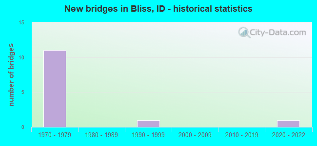
- New bridges - historical statistics
- 111970-1979
- 11990-1999
- 12020-2022


- Bridge Condition - Deck
- 88.9%Good
- 11.1%Satisfactory

- Bridge Condition - Superstructure
- 11.1%Excellent
- 22.2%Good
- 66.7%Satisfactory

- Bridge Condition - Substructure
- 11.1%Excellent
- 22.2%Good
- 66.7%Satisfactory
Find on map >> Show street view
Structure Number: 13095, Location: 1.7 E. BLISS (Lat: 42.923556, Lng: -114.935139), Route carried "on" structure: US 26, Year Built: 1974, Status: Open, Structure Length: 11.19m (36.71ft), Average Daily Traffic: 2,500 (year 2019), Truck Traffic: 4%, Average Future Daily Traffic: 3,750 (year 2039), Design Load: HS 20, Features Intersected: I 84 EB-WB;E.BLISS IC
Minimum Vertical Clearance: 30+ m (98+ ft), Kilometerpoint: 223.434, Lanes on structure: 2, Lanes under structure: 4, Base Highway Network: Yes, Owner: State Highway Agency, Approaching Roadway Width: 17.1m (56.1ft), Skew: 4 degrees, Material/Design: Prestressed concrete continuous, Design/Construction: Box Beam or Girders - Single/Spread, Number Of Spans In Main Unit: 2, Length of Maximum Span: 54.6m (179.1ft), Curb-To-Curb Width: 18.3m (60.0ft), Out-to-Out Width: 19.1m (62.7ft)
Condition: Deck: Good, Superstructure: Satisfactory, Substructure: Satisfactory, Operating Rating: 48.1 metric tons, Method Used To Determine Operating Rating: Load and Resistance Factor (LRFR), Inventory Rating: 37.2 metric tons, Method Used To Determine Inventory Rating: Load and Resistance Factor (LRFR), Structural Evaluation: Equal to present minimum criteria, Deck Geometry: Superior to present desirable criteria, Underclear: Equal to present minimum criteria, Approach Roadway Alignment: Equal to present desirable criteria, Designated Inspection Frequency: Every 48 months, Inspection Date: June 2020, Deck Structure Type: Concrete Cast-file-Place, Wearing Surface/Protective System: Wearing Surface: Epoxy Overlay
Find on map >> Show street view
Structure Number: 13535, Location: 1.7 W. BLISS (Lat: 42.938444, Lng: -114.993528), Route carried "on" structure: US 30, Year Built: 1974, Status: Open, Structure Length: 9.27m (30.41ft), Average Daily Traffic: 680 (year 2019), Truck Traffic: 15%, Average Future Daily Traffic: 1,020 (year 2039), Design Load: HS 20, Features Intersected: I 84 WB-EB;W.BLISS IC
Minimum Vertical Clearance: 30+ m (98+ ft), Kilometerpoint: 272.785, Lanes on structure: 2, Lanes under structure: 4, Base Highway Network: Yes (Inventory Route: US0, Subroute: 1), Owner: State Highway Agency, Approaching Roadway Width: 10.4m (34.1ft), Skew: 3 degrees, Material/Design: Prestressed concrete continuous, Design/Construction: Box Beam or Girders - Single/Spread, Number Of Spans In Main Unit: 2, Length of Maximum Span: 45.1m (148.0ft), Curb-To-Curb Width: 11.6m (38.1ft), Out-to-Out Width: 12.3m (40.4ft)
Condition: Deck: Good, Superstructure: Satisfactory, Substructure: Satisfactory, Operating Rating: 47.2 metric tons, Method Used To Determine Operating Rating: Load and Resistance Factor (LRFR), Inventory Rating: 33.6 metric tons, Method Used To Determine Inventory Rating: Load and Resistance Factor (LRFR), Structural Evaluation: Equal to present minimum criteria, Deck Geometry: Better than present minimum criteria, Underclear: Equal to present minimum criteria, Approach Roadway Alignment: Equal to present desirable criteria, Designated Inspection Frequency: Every 48 months, Inspection Date: April 2021, Deck Structure Type: Concrete Cast-file-Place, Wearing Surface/Protective System: Wearing Surface: Epoxy Overlay
Find on map >> Show street view
Structure Number: 13546, Location: 1.3 W. BLISS (Lat: 42.926667, Lng: -114.971389), Route carried "on" structure: US 30, Year Built: 2020, Status: Open, Structure Length: 7.13m (23.39ft), Average Daily Traffic: 1,100 (year 2019), Truck Traffic: 16%, Average Future Daily Traffic: 1,650 (year 2039), Design Load: HL 93, Features Intersected: UPRR BLISS RAILROAD OP
Minimum Vertical Clearance: 30+ m (98+ ft), Kilometerpoint: 229.848, Lanes on structure: 2, Base Highway Network: Yes (Inventory Route: US0, Subroute: 1), Owner: State Highway Agency, Approaching Roadway Width: 11.7m (38.4ft), Skew: 4 degrees, Material/Design: Prestressed concrete, Design/Construction: Stringer/Multi-beam, Number Of Spans In Main Unit: 2, Length of Maximum Span: 36.4m (119.4ft), Curb-To-Curb Width: 12.0m (39.4ft), Out-to-Out Width: 12.8m (42.0ft)
Condition: Deck: Good, Superstructure: Excellent, Substructure: Excellent, Operating Rating: 67.1 metric tons, Method Used To Determine Operating Rating: Load and Resistance Factor Rating (LRFR) rating reported by rating factor(RF) method using HL-93 loadings, Inventory Rating: 42.8 metric tons, Method Used To Determine Inventory Rating: Load and Resistance Factor Rating (LRFR) rating reported by rating factor(RF) method using HL-93 loadings, Structural Evaluation: Superior to present desirable criteria, Deck Geometry: Equal to present minimum criteria, Underclear: Superior to present desirable criteria, Approach Roadway Alignment: Equal to present desirable criteria, Designated Inspection Frequency: Every 24 months, Inspection Date: April 2020, Deck Structure Type: Concrete Cast-file-Place, Wearing Surface/Protective System: Wearing Surface: Monolithic Concrete, Deck Protection: Epoxy Coated Reinforcing
Find on map >> Show street view
Structure Number: 16015, Location: BLISS EAST CITY LIMITS (Lat: 42.927194, Lng: -114.939833), Route carried "on" structure: Interstate 84, Year Built: 1975, Status: Open, Structure Length: 7.47m (24.51ft), Average Daily Traffic: 8,750 (year 2019), Truck Traffic: 35%, Average Future Daily Traffic: 13,125 (year 2039), Design Load: HS 20, Features Intersected: UPRR;E.BLISS RAILROAD OP
Minimum Vertical Clearance: 30+ m (98+ ft), Kilometerpoint: 225.406, Lanes on structure: 3, Base Highway Network: Yes (Inventory Route: I, Subroute: 2), Owner: State Highway Agency, Approaching Roadway Width: 15.2m (49.9ft), Skew: 4 degrees, Material/Design: Prestressed concrete continuous, Design/Construction: Stringer/Multi-beam, Number Of Spans In Main Unit: 3, Length of Maximum Span: 32.3m (106.0ft), Curb-To-Curb Width: 16.5m (54.1ft), Out-to-Out Width: 17.2m (56.4ft)
Condition: Deck: Good, Superstructure: Satisfactory, Substructure: Satisfactory, Operating Rating: 59.0 metric tons, Method Used To Determine Operating Rating: Load Factor (LF), Inventory Rating: 35.4 metric tons, Method Used To Determine Inventory Rating: Load Factor (LF), Structural Evaluation: Equal to present minimum criteria, Deck Geometry: Equal to present minimum criteria, Underclear: Superior to present desirable criteria, Approach Roadway Alignment: Equal to present desirable criteria, Designated Inspection Frequency: Every 48 months, Inspection Date: March 2019, Deck Structure Type: Concrete Cast-file-Place, Wearing Surface/Protective System: Wearing Surface: Epoxy Overlay
Find on map >> Show street view
Structure Number: 1602, Location: BLISS EAST CITY LIMITS (Lat: 42.926722, Lng: -114.938556), Route carried "on" structure: Interstate 84, Year Built: 1975, Status: Open, Structure Length: 7.47m (24.51ft), Average Daily Traffic: 8,750 (year 2019), Truck Traffic: 35%, Average Future Daily Traffic: 13,125 (year 2039), Design Load: HS 20, Features Intersected: UPRR;E.BLISS RAILROAD OP
Minimum Vertical Clearance: 30+ m (98+ ft), Kilometerpoint: 225.428, Lanes on structure: 3, Base Highway Network: Yes (Inventory Route: I, Subroute: 2), Owner: State Highway Agency, Approaching Roadway Width: 15.2m (49.9ft), Skew: 4 degrees, Material/Design: Prestressed concrete continuous, Design/Construction: Stringer/Multi-beam, Number Of Spans In Main Unit: 3, Length of Maximum Span: 32.3m (106.0ft), Curb-To-Curb Width: 16.5m (54.1ft), Out-to-Out Width: 17.2m (56.4ft)
Condition: Deck: Good, Superstructure: Satisfactory, Substructure: Satisfactory, Operating Rating: 59.0 metric tons, Method Used To Determine Operating Rating: Load Factor (LF), Inventory Rating: 35.4 metric tons, Method Used To Determine Inventory Rating: Load Factor (LF), Structural Evaluation: Equal to present minimum criteria, Deck Geometry: Equal to present minimum criteria, Underclear: Superior to present desirable criteria, Approach Roadway Alignment: Equal to present desirable criteria, Designated Inspection Frequency: Every 48 months, Inspection Date: March 2019, Deck Structure Type: Concrete Cast-file-Place, Wearing Surface/Protective System: Wearing Surface: Epoxy Overlay
Find on map >> Show street view
Structure Number: 24495, Location: 0.6 E. BLISS (Lat: 42.933889, Lng: -114.949444), Route carried "on" structure: County highway , Year Built: 1975, Status: Open, Structure Length: 11.00m (36.09ft), Average Daily Traffic: 340 (year 2019), Truck Traffic: 12%, Average Future Daily Traffic: 510 (year 2039), Design Load: HS 20, Features Intersected: I 84;CLOVER CREEK RD GS, Facility Carried by Structure: CLOVER CREEK RD
Minimum Vertical Clearance: 30+ m (98+ ft), Kilometerpoint: 170.647, Lanes on structure: 2, Lanes under structure: 4, Owner: State Highway Agency, Approaching Roadway Width: 8.5m (27.9ft), Skew: 4 degrees, Material/Design: Prestressed concrete continuous, Design/Construction: Box Beam or Girders - Multiple, Number Of Spans In Main Unit: 2, Length of Maximum Span: 53.6m (175.9ft), Curb-To-Curb Width: 9.8m (32.2ft), Out-to-Out Width: 10.5m (34.4ft)
Condition: Deck: Good, Superstructure: Satisfactory, Substructure: Satisfactory, Operating Rating: 54.4 metric tons, Method Used To Determine Operating Rating: Load and Resistance Factor (LRFR), Inventory Rating: 22.7 metric tons, Method Used To Determine Inventory Rating: Load and Resistance Factor (LRFR), Structural Evaluation: Equal to present minimum criteria, Deck Geometry: Better than present minimum criteria, Underclear: Equal to present minimum criteria, Approach Roadway Alignment: Equal to present desirable criteria, Designated Inspection Frequency: Every 48 months, Inspection Date: June 2021, Deck Structure Type: Concrete Cast-file-Place, Wearing Surface/Protective System: Wearing Surface: Epoxy Overlay
Find on map >> Show street view
Structure Number: 245, Location: 3.1 E. BLISS (Lat: 42.892653, Lng: -114.891786), Route carried "on" structure: County highway , Year Built: 1977, Status: Open, Structure Length: 12.10m (39.70ft), Average Daily Traffic: 60 (year 2019), Truck Traffic: 10%, Average Future Daily Traffic: 90 (year 2039), Design Load: HS 20, Features Intersected: I 84 EB-WB;FR.RD GS NO.1, Facility Carried by Structure: E 2100 S
Minimum Vertical Clearance: 30+ m (98+ ft), Kilometerpoint: 165.064, Lanes on structure: 2, Lanes under structure: 4, Owner: State Highway Agency, Approaching Roadway Width: 7.9m (25.9ft), Material/Design: Steel continuous, Design/Construction: Stringer/Multi-beam, Number Of Spans In Main Unit: 3, Length of Maximum Span: 40.8m (133.9ft), Curb-To-Curb Width: 8.5m (27.9ft), Out-to-Out Width: 9.3m (30.5ft)
Condition: Deck: Good, Superstructure: Good, Substructure: Good, Operating Rating: 63.5 metric tons, Method Used To Determine Operating Rating: Load Factor (LF), Inventory Rating: 37.8 metric tons, Method Used To Determine Inventory Rating: Load Factor (LF), Structural Evaluation: Better than present minimum criteria, Deck Geometry: Better than present minimum criteria, Underclear: Better than present minimum criteria, Approach Roadway Alignment: Equal to present desirable criteria, Designated Inspection Frequency: Every 48 months, Other Special Inspection Frequency: Every 48 months, Inspection Date: May 2020, Other Special Inspection Date: May 2020, Deck Structure Type: Concrete Cast-file-Place, Wearing Surface/Protective System: Wearing Surface: Epoxy Overlay, Deck Protection: Epoxy Coated Reinforcing
Find on map >> Show street view
Structure Number: 2537, Location: 1.0 S. 1.5 W. BLISS (Lat: 42.911528, Lng: -114.972000), Route carried "on" structure: County highway , Year Built: 1977, Status: Open, Structure Length: 1.62m (5.31ft), Average Daily Traffic: 30 (year 2019), Average Future Daily Traffic: 45 (year 2039), Design Load: HS 20, Features Intersected: KING HILL MAIN CANAL, Facility Carried by Structure: SHOESTRING ROAD
Minimum Vertical Clearance: 30+ m (98+ ft), Kilometerpoint: 171.101, Lanes on structure: 2, Owner: Local Agency, Approaching Roadway Width: 8.5m (27.9ft), Skew: 2 degrees, Material/Design: Prestressed concrete, Design/Construction: Tee Beam, Number Of Spans In Main Unit: 1, Length of Maximum Span: 15.2m (49.9ft), Curb-To-Curb Width: 8.7m (28.5ft), Out-to-Out Width: 9.7m (31.8ft)
Condition: Deck: Satisfactory, Superstructure: Satisfactory, Substructure: Satisfactory, Channel: Good, Operating Rating: 51.7 metric tons, Method Used To Determine Operating Rating: Load Factor (LF), Inventory Rating: 30.8 metric tons, Method Used To Determine Inventory Rating: Load Factor (LF), Structural Evaluation: Equal to present minimum criteria, Deck Geometry: Better than present minimum criteria, Waterway Adequacy: Equal to present desirable criteria, Approach Roadway Alignment: Equal to present minimum criteria, Designated Inspection Frequency: Every 24 months, Inspection Date: March 2020, Deck Structure Type: Concrete Cast-file-Place, Wearing Surface/Protective System: Wearing Surface: Monolithic Concrete
Find on map >> Show street view
Structure Number: L59835, Location: 2.4 mi N of ID26 (Lat: 42.956939, Lng: -114.887500), Route carried "on" structure: Federal lands road , Year Built: 1991, Status: Open, Structure Length: 0.91m (2.99ft), Average Daily Traffic: 25 (year 2011), Truck Traffic: 10%, Average Future Daily Traffic: 35 (year 2040), Design Load: HS 20, Features Intersected: Y-1 Canal, Facility Carried by Structure: 2416: TEAKETTLE RO
Minimum Vertical Clearance: 30+ m (98+ ft), Kilometerpoint: 0.000, Lanes on structure: 1, Owner: Bureau of Land Management, Approaching Roadway Width: 4.0m (13.1ft), Material/Design: Wood or Timber, Design/Construction: Stringer/Multi-beam, Number Of Spans In Main Unit: 1, Length of Maximum Span: 8.8m (28.9ft), Curb or Sidewalk Widths: Left: 0.2m (0.7ft), Right: 0.2m (0.7ft), Curb-To-Curb Width: 4.0m (13.1ft), Out-to-Out Width: 4.9m (16.1ft)
Condition: Deck: Good, Superstructure: Good, Substructure: Good, Channel: Good, Operating Rating: 39.5 metric tons, Method Used To Determine Operating Rating: Load and Resistance Factor Rating (LRFR) rating reported by rating factor(RF) method using HL-93 loadings, Inventory Rating: 30.5 metric tons, Method Used To Determine Inventory Rating: Load and Resistance Factor Rating (LRFR) rating reported by rating factor(RF) method using HL-93 loadings, Structural Evaluation: Better than present minimum criteria, Deck Geometry: Somewhat better than minimum adequacy, Waterway Adequacy: Equal to present minimum criteria, Approach Roadway Alignment: Equal to present minimum criteria, Designated Inspection Frequency: Every 24 months, Inspection Date: October 2020, Deck Structure Type: Wood or Timber, Wearing Surface/Protective System: Wearing Surface: Wood or Timber
Find on map >> Show street view
Structure Number: 13095, Location: 1.7 E. BLISS (Lat: 42.923556, Lng: -114.935139), Route carried "under" structure: Interstate 84, Year Built: 1974, Structure Length: 0. m, Average Daily Traffic: 17,000 (year 2018), Truck Traffic: 36%, Features Intersected: I 84 EB-WB;E.BLISS IC, Facility Carried by Structure: US 26
Minimum Vertical Clearance: 5.51m (18.08ft), Kilometerpoint: 225.992, Lanes on structure: 2, Lanes under structure: 4, Material/Design: Prestressed concrete continuous, Design/Construction: Box Beam or Girders - Single/Spread, Length of Maximum Span: 54.6m (179.1ft)
Find on map >> Show street view
Structure Number: 13535, Location: 1.7 W. BLISS (Lat: 42.938444, Lng: -114.993528), Route carried "under" structure: Interstate 84, Year Built: 1974, Structure Length: 0. m, Average Daily Traffic: 17,500 (year 2018), Truck Traffic: 35%, Features Intersected: I 84 WB-EB;W.BLISS IC, Facility Carried by Structure: US 30
Minimum Vertical Clearance: 5.18m (16.99ft), Kilometerpoint: 220.622, Lanes on structure: 2, Lanes under structure: 4, Material/Design: Prestressed concrete continuous, Design/Construction: Box Beam or Girders - Single/Spread, Length of Maximum Span: 45.1m (148.0ft)
Find on map >> Show street view
Structure Number: 24495, Location: 0.6 E. BLISS (Lat: 42.933889, Lng: -114.949444), Route carried "under" structure: Interstate 84, Year Built: 1975, Structure Length: 0. m, Average Daily Traffic: 17,000 (year 2018), Truck Traffic: 36%, Features Intersected: I 84;CLOVER CREEK RD GS, Facility Carried by Structure: CLOVER CREEK RD
Minimum Vertical Clearance: 5.36m (17.59ft), Kilometerpoint: 224.305, Lanes on structure: 2, Lanes under structure: 4, Material/Design: Prestressed concrete continuous, Design/Construction: Box Beam or Girders - Multiple, Length of Maximum Span: 53.6m (175.9ft)
Find on map >> Show street view
Structure Number: 245, Location: 3.1 E. BLISS (Lat: 42.892653, Lng: -114.891786), Route carried "under" structure: Interstate 84, Year Built: 1977, Structure Length: 0. m, Average Daily Traffic: 16,500 (year 2018), Truck Traffic: 36%, Features Intersected: I 84 EB-WB;FR.RD GS NO.1, Facility Carried by Structure: E 2100 S
Minimum Vertical Clearance: 6.11m (20.05ft), Kilometerpoint: 230.917, Lanes on structure: 2, Lanes under structure: 4, Material/Design: Steel continuous, Design/Construction: Stringer/Multi-beam, Length of Maximum Span: 40.8m (133.9ft)