Bridge Statistics for Blooming Grove, New York (NY)
Condition, Traffic, Stress, Structural Evaluation, Project Costs
- National Bridge Inventory (NBI) Statistics
- 27Number of bridges
- 184ft / 56.0mTotal length
- $55,636,000Total costs
- 221,993Total average daily traffic
- 4,201Total average daily truck traffic
- National Bridge Inventory (NBI) Registered Bridges for Blooming Grove
- No street view available for this location
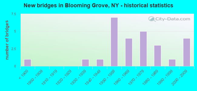
- New bridges - historical statistics
- 1Before 1900
- 11930-1939
- 11940-1949
- 71950-1959
- 41960-1969
- 51970-1979
- 31980-1989
- 11990-1999
- 42000-2009
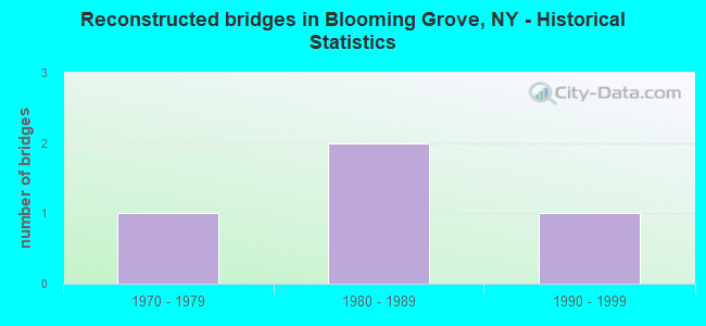
- Reconstructed bridges - Historical Statistics
- 11970-1979
- 21980-1989
- 11990-1999
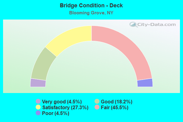
- Bridge Condition - Deck
- 4.5%Very good
- 18.2%Good
- 27.3%Satisfactory
- 45.5%Fair
- 4.5%Poor
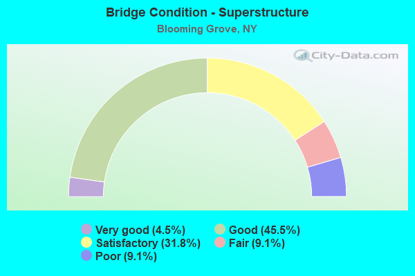
- Bridge Condition - Superstructure
- 4.5%Very good
- 45.5%Good
- 31.8%Satisfactory
- 9.1%Fair
- 9.1%Poor
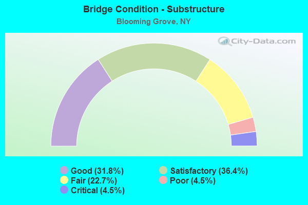
- Bridge Condition - Substructure
- 31.8%Good
- 36.4%Satisfactory
- 22.7%Fair
- 4.5%Poor
- 4.5%Critical
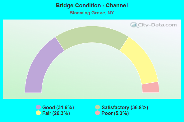
- Bridge Condition - Channel
- 31.6%Good
- 36.8%Satisfactory
- 26.3%Fair
- 5.3%Poor
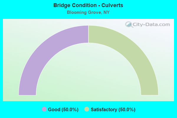
- Bridge Condition - Culverts
- 50.0%Good
- 50.0%Satisfactory
Find on map >> Show street view
Structure Number: 100325, Location: AT SH 17/US 6 EXIT 128 (Lat: 41.346889, Lng: -74.224767), Route carried "on" structure: County highway , Year Built: 2002, Status: Open, Structure Length: 7.22m (23.69ft), Average Daily Traffic: 1,381 (year 2018), Truck Traffic: 5%, Average Future Daily Traffic: 1,708 (year 2040), Design Load: HS 25 or greater, Features Intersected: 17 17 83101202 WB, RTE, Facility Carried by Structure: OXFORD ROAD
Minimum Vertical Clearance: 30+ m (98+ ft), Kilometerpoint: 0.209, Lanes on structure: 2, Lanes under structure: 4, Owner: State Highway Agency, Approaching Roadway Width: 11.6m (38.1ft), Skew: 4 degrees, Material/Design: Steel continuous, Design/Construction: Stringer/Multi-beam, Number Of Spans In Main Unit: 2, Length of Maximum Span: 35.0m (114.8ft), Curb-To-Curb Width: 10.2m (33.5ft), Out-to-Out Width: 11.1m (36.4ft)
Condition: Deck: Fair, Superstructure: Good, Substructure: Good, Operating Rating: 46.7 metric tons, Method Used To Determine Operating Rating: Load and Resistance Factor Rating (LRFR) rating reported by rating factor(RF) method using HL-93 loadings, Inventory Rating: 36.0 metric tons, Method Used To Determine Inventory Rating: Load and Resistance Factor Rating (LRFR) rating reported by rating factor(RF) method using HL-93 loadings, Structural Evaluation: Better than present minimum criteria, Deck Geometry: Somewhat better than minimum adequacy, Underclear: Equal to present minimum criteria, Approach Roadway Alignment: Equal to present desirable criteria, Length Of Structure Improvement: 7.22m (23.69ft), Designated Inspection Frequency: Every 24 months, Inspection Date: March 2021, Bridge Improvement Cost: $4,097,000, Roadway Improvement Cost: $2,399,000, Total Project Cost: $6,496,000 ( Estimate for 2021), Deck Structure Type: Concrete Cast-file-Place, Wearing Surface/Protective System: Wearing Surface: Integral Concrete
Find on map >> Show street view
Structure Number: 100326, Location: BLOOMING GROVE (Lat: 41.345936, Lng: -74.212544), Route carried "on" structure: US 6, Year Built: 1956, Year Reconstructed: 1992, Status: Open, Structure Length: 5.27m (17.29ft), Average Daily Traffic: 52,825 (year 2020), Truck Traffic: 2%, Average Future Daily Traffic: 74,520 (year 2040), Design Load: HS 20, Features Intersected: HERITAGE TRAIL
Minimum Vertical Clearance: 30+ m (98+ ft), Kilometerpoint: 50.362, Lanes on structure: 4, Base Highway Network: Yes, Owner: State Highway Agency, Approaching Roadway Width: 34.4m (112.9ft), Skew: 32 degrees, Material/Design: Steel continuous, Design/Construction: Stringer/Multi-beam, Number Of Spans In Main Unit: 3, Length of Maximum Span: 19.5m (64.0ft), Curb-To-Curb Width: 33.6m (110.2ft), Out-to-Out Width: 34.5m (113.2ft)
Condition: Deck: Satisfactory, Superstructure: Very good, Substructure: Satisfactory, Inventory Rating: 72.6 metric tons, Method Used To Determine Inventory Rating: Load Factor (LF), Structural Evaluation: Equal to present minimum criteria, Deck Geometry: Superior to present desirable criteria, Approach Roadway Alignment: Equal to present desirable criteria, Length Of Structure Improvement: 5.27m (17.29ft), Designated Inspection Frequency: Every 24 months, Inspection Date: July 2021, Bridge Improvement Cost: $7,404,000, Roadway Improvement Cost: $4,336,000, Total Project Cost: $11,740,000 ( Estimate for 2021), Deck Structure Type: Concrete Cast-file-Place, Wearing Surface/Protective System: Wearing Surface: Integral Concrete, Deck Protection: Epoxy Coated Reinforcing
Find on map >> Show street view
Structure Number: 100327, Location: 0.6 MI W RTE 17 INT 130 (Lat: 41.347528, Lng: -74.200244), Route carried "on" structure: County highway , Year Built: 1956, Year Reconstructed: 1983, Status: Open, Structure Length: 6.49m (21.29ft), Average Daily Traffic: 4,029 (year 2020), Truck Traffic: 4%, Average Future Daily Traffic: 5,641 (year 2040), Design Load: HS 20, Features Intersected: 17 17 83101215 WB, RTE, Facility Carried by Structure: MUSEUM VILLAGE RD
Minimum Vertical Clearance: 30+ m (98+ ft), Kilometerpoint: 1.818, Lanes on structure: 2, Lanes under structure: 6, Owner: State Highway Agency, Approaching Roadway Width: 9.4m (30.8ft), Material/Design: Steel, Design/Construction: Stringer/Multi-beam, Number Of Spans In Main Unit: 4, Length of Maximum Span: 17.6m (57.7ft), Curb-To-Curb Width: 9.1m (29.9ft), Out-to-Out Width: 10.1m (33.1ft)
Condition: Deck: Very good, Superstructure: Satisfactory, Substructure: Poor, Operating Rating: 78.9 metric tons, Method Used To Determine Operating Rating: Load Factor (LF), Inventory Rating: 47.2 metric tons, Method Used To Determine Inventory Rating: Load Factor (LF), Structural Evaluation: Meets minimum limits, Deck Geometry: Meets minimum limits, Underclear: Meets minimum limits, Approach Roadway Alignment: Equal to present desirable criteria, Length Of Structure Improvement: 6.49m (21.29ft), Designated Inspection Frequency: Every 24 months, Inspection Date: April 2021, Bridge Improvement Cost: $3,066,000, Roadway Improvement Cost: $1,795,000, Total Project Cost: $4,861,000 ( Estimate for 2021), Deck Structure Type: Concrete Cast-file-Place, Wearing Surface/Protective System: Wearing Surface: Integral Concrete, Deck Protection: Epoxy Coated Reinforcing
Find on map >> Show street view
Structure Number: 100328, Location: BETWEEN EX 129-130 - US6 (Lat: 41.346264, Lng: -74.194164), Route carried "on" structure: US 17, Year Built: 1956, Year Reconstructed: 1992, Status: Open, Structure Length: 1.86m (6.10ft), Average Daily Traffic: 52,825 (year 2020), Truck Traffic: 2%, Average Future Daily Traffic: 74,520 (year 2040), Design Load: HS 20, Features Intersected: ORANGE-ROCKLAND LAKE
Minimum Vertical Clearance: 30+ m (98+ ft), Kilometerpoint: 51.955, Lanes on structure: 4, Base Highway Network: Yes, Owner: State Highway Agency, Approaching Roadway Width: 22.9m (75.1ft), Skew: 30 degrees, Material/Design: Steel, Design/Construction: Stringer/Multi-beam, Number Of Spans In Main Unit: 1, Length of Maximum Span: 17.3m (56.8ft), Curb-To-Curb Width: 33.9m (111.2ft), Out-to-Out Width: 34.5m (113.2ft)
Condition: Deck: Satisfactory, Superstructure: Good, Substructure: Fair, Channel: Good, Operating Rating: 66.2 metric tons, Method Used To Determine Operating Rating: Load Factor (LF), Inventory Rating: 39.9 metric tons, Method Used To Determine Inventory Rating: Load Factor (LF), Structural Evaluation: Somewhat better than minimum adequacy, Deck Geometry: Superior to present desirable criteria, Waterway Adequacy: Equal to present minimum criteria, Approach Roadway Alignment: Equal to present desirable criteria, Length Of Structure Improvement: 1.85m (6.07ft), Designated Inspection Frequency: Every 24 months, Inspection Date: August 2021, Bridge Improvement Cost: $3,794,000, Roadway Improvement Cost: $2,221,000, Total Project Cost: $6,015,000 ( Estimate for 2021), Deck Structure Type: Concrete Cast-file-Place, Wearing Surface/Protective System: Wearing Surface: Integral Concrete, Deck Protection: Epoxy Coated Reinforcing
Find on map >> Show street view
Structure Number: 103484, Location: 2.9 MI E JCT SH94 & SH17M (Lat: 41.378331, Lng: -74.240508), Route carried "on" structure: State highway 94, Year Built: 1978, Status: Open, Structure Length: 1.01m (3.31ft), Average Daily Traffic: 4,827 (year 2020), Truck Traffic: 5%, Average Future Daily Traffic: 5,863 (year 2040), Design Load: HS 20, Features Intersected: MIDDLETOWN & NJ R
Minimum Vertical Clearance: 30+ m (98+ ft), Kilometerpoint: 28.158, Lanes on structure: 2, Base Highway Network: Yes, Owner: State Highway Agency, Approaching Roadway Width: 10.4m (34.1ft), Material/Design: Steel, Design/Construction: Culvert, Number Of Spans In Main Unit: 1, Length of Maximum Span: 9.7m (31.8ft)
Condition: Culverts: Good, Operating Rating: 79.5 metric tons, Method Used To Determine Operating Rating: Field evaluation and documented engineering judgment, Inventory Rating: 32.7 metric tons, Method Used To Determine Inventory Rating: Field evaluation and documented engineering judgment, Structural Evaluation: Better than present minimum criteria, Underclear: Somewhat better than minimum adequacy, Approach Roadway Alignment: Equal to present desirable criteria, Length Of Structure Improvement: 1.00m (3.28ft), Designated Inspection Frequency: Every 24 months, Inspection Date: November 2021, Bridge Improvement Cost: $294,000, Roadway Improvement Cost: $172,000, Total Project Cost: $466,000 ( Estimate for 2021)
Find on map >> Show street view
Structure Number: 103485, Location: 3.5 MI E JCT RTS 94 & 17M (Lat: 41.384608, Lng: -74.232475), Route carried "on" structure: State highway 94, Year Built: 1992, Status: Open, Structure Length: 1.95m (6.40ft), Average Daily Traffic: 4,827 (year 2020), Truck Traffic: 5%, Average Future Daily Traffic: 5,863 (year 2040), Design Load: HS 20, Features Intersected: CROMLINE CREEK
Minimum Vertical Clearance: 30+ m (98+ ft), Kilometerpoint: 29.123, Lanes on structure: 2, Base Highway Network: Yes, Owner: State Highway Agency, Approaching Roadway Width: 11.0m (36.1ft), Skew: 3 degrees, Material/Design: Steel, Design/Construction: Stringer/Multi-beam, Number Of Spans In Main Unit: 1, Length of Maximum Span: 17.6m (57.7ft), Curb-To-Curb Width: 11.0m (36.1ft), Out-to-Out Width: 11.6m (38.1ft)
Condition: Deck: Satisfactory, Superstructure: Good, Substructure: Good, Channel: Good, Operating Rating: 67.1 metric tons, Method Used To Determine Operating Rating: Allowable Stress (AS), Inventory Rating: 41.7 metric tons, Method Used To Determine Inventory Rating: Allowable Stress (AS), Structural Evaluation: Better than present minimum criteria, Deck Geometry: Somewhat better than minimum adequacy, Waterway Adequacy: Somewhat better than minimum adequacy, Approach Roadway Alignment: Equal to present desirable criteria, Length Of Structure Improvement: 1.95m (6.40ft), Designated Inspection Frequency: Every 24 months, Inspection Date: November 2020, Bridge Improvement Cost: $1,195,000, Roadway Improvement Cost: $700,000, Total Project Cost: $1,895,000 ( Estimate for 2021), Deck Structure Type: Concrete Cast-file-Place, Wearing Surface/Protective System: Wearing Surface: Integral Concrete, Deck Protection: Epoxy Coated Reinforcing
Find on map >> Show street view
Structure Number: 103488, Location: 0.8 MI W JCT RTS 94+208 (Lat: 41.419550, Lng: -74.175111), Route carried "on" structure: State highway 94, Year Built: 1976, Status: Open, Structure Length: 3.11m (10.20ft), Average Daily Traffic: 4,827 (year 2020), Truck Traffic: 5%, Average Future Daily Traffic: 5,863 (year 2040), Design Load: HS 20, Features Intersected: MOODNA CREEK
Minimum Vertical Clearance: 30+ m (98+ ft), Kilometerpoint: 35.478, Lanes on structure: 2, Base Highway Network: Yes, Owner: State Highway Agency, Approaching Roadway Width: 9.1m (29.9ft), Material/Design: Prestressed concrete, Design/Construction: Box Beam or Girders - Multiple, Number Of Spans In Main Unit: 1, Length of Maximum Span: 29.8m (97.8ft), Curb-To-Curb Width: 10.5m (34.4ft), Out-to-Out Width: 11.3m (37.1ft)
Condition: Deck: Fair, Superstructure: Poor, Substructure: Satisfactory, Channel: Good, Operating Rating: 66.2 metric tons, Method Used To Determine Operating Rating: Load Factor (LF), Inventory Rating: 31.8 metric tons, Method Used To Determine Inventory Rating: Load Factor (LF), Structural Evaluation: Meets minimum limits, Deck Geometry: Somewhat better than minimum adequacy, Waterway Adequacy: Somewhat better than minimum adequacy, Approach Roadway Alignment: Equal to present desirable criteria, Length Of Structure Improvement: 3.10m (10.17ft), Designated Inspection Frequency: Every 24 months, Inspection Date: July 2021, Bridge Improvement Cost: $963,000, Roadway Improvement Cost: $564,000, Total Project Cost: $1,527,000 ( Estimate for 2021), Wearing Surface/Protective System: Wearing Surface: Bituminous
Find on map >> Show street view
Structure Number: 103489, Location: 2.2 MI E JCT SH94 & SH208 (Lat: 41.431436, Lng: -74.126608), Route carried "on" structure: State highway 94, Year Built: 1936, Status: Open, Structure Length: 1.10m (3.61ft), Average Daily Traffic: 6,857 (year 2018), Truck Traffic: 4%, Average Future Daily Traffic: 6,889 (year 2040), Design Load: HS 20, Features Intersected: TRIBUTARY TO MOODNA CRE
Minimum Vertical Clearance: 30+ m (98+ ft), Kilometerpoint: 40.241, Lanes on structure: 2, Base Highway Network: Yes, Owner: State Highway Agency, Approaching Roadway Width: 9.4m (30.8ft), Skew: 1 degrees, Material/Design: Concrete, Design/Construction: Tee Beam, Number Of Spans In Main Unit: 1, Length of Maximum Span: 9.4m (30.8ft), Curb-To-Curb Width: 9.4m (30.8ft), Out-to-Out Width: 10.6m (34.8ft)
Condition: Deck: Satisfactory, Superstructure: Satisfactory, Substructure: Satisfactory, Channel: Satisfactory, Operating Rating: 61.7 metric tons, Method Used To Determine Operating Rating: Load Factor (LF), Inventory Rating: 37.2 metric tons, Method Used To Determine Inventory Rating: Load Factor (LF), Structural Evaluation: Equal to present minimum criteria, Deck Geometry: High priority of corrective action, Waterway Adequacy: Meets minimum limits, Approach Roadway Alignment: Meets minimum limits, Length Of Structure Improvement: 1.09m (3.58ft), Designated Inspection Frequency: Every 24 months, Inspection Date: July 2021, Bridge Improvement Cost: $566,000, Roadway Improvement Cost: $332,000, Total Project Cost: $898,000 ( Estimate for 2021), Deck Structure Type: Concrete Cast-file-Place, Wearing Surface/Protective System: Wearing Surface: Bituminous
Find on map >> Show street view
Structure Number: 222307, Location: 1.1 MI SE WASHINGTONVILLE (Lat: 41.412278, Lng: -74.160297), Route carried "on" structure: Other road , Year Built: 1987, Status: Open, Structure Length: 0.94m (3.08ft), Average Daily Traffic: 277 (year 2017), Truck Traffic: 4%, Average Future Daily Traffic: 388 (year 2037), Features Intersected: PERRY CREEK, Facility Carried by Structure: PERRY CREEK ROAD
Minimum Vertical Clearance: 30+ m (98+ ft), Kilometerpoint: 0.386, Lanes on structure: 2, Owner: Town or Township Highway Agency, Approaching Roadway Width: 7.6m (24.9ft), Skew: 1 degrees, Material/Design: Prestressed concrete, Design/Construction: Box Beam or Girders - Multiple, Number Of Spans In Main Unit: 1, Length of Maximum Span: 8.2m (26.9ft), Curb-To-Curb Width: 7.4m (24.3ft), Out-to-Out Width: 8.3m (27.2ft)
Condition: Deck: Good, Superstructure: Good, Substructure: Good, Channel: Fair, Operating Rating: 78.4 metric tons, Method Used To Determine Operating Rating: Field evaluation and documented engineering judgment, Inventory Rating: 32.7 metric tons, Method Used To Determine Inventory Rating: Field evaluation and documented engineering judgment, Structural Evaluation: Better than present minimum criteria, Deck Geometry: Somewhat better than minimum adequacy, Waterway Adequacy: Meets minimum limits, Approach Roadway Alignment: Equal to present desirable criteria, Length Of Structure Improvement: 0.94m (3.08ft), Designated Inspection Frequency: Every 24 months, Inspection Date: September 2020, Bridge Improvement Cost: $347,000, Roadway Improvement Cost: $203,000, Total Project Cost: $550,000 ( Estimate for 2021), Wearing Surface/Protective System: Wearing Surface: Bituminous, Membrane: Other
Find on map >> Show street view
Structure Number: 222308, Location: 0.9MI SE WASHINGTONVILLE (Lat: 41.415061, Lng: -74.160469), Route carried "on" structure: Other road , Year Built: 1987, Status: Open, Structure Length: 0.98m (3.22ft), Average Daily Traffic: 853 (year 2017), Truck Traffic: 2%, Average Future Daily Traffic: 1,194 (year 2037), Features Intersected: PERRY CREEK, Facility Carried by Structure: WOODCOCK MOUNTAIN
Minimum Vertical Clearance: 30+ m (98+ ft), Kilometerpoint: 0.708, Lanes on structure: 2, Owner: Town or Township Highway Agency, Approaching Roadway Width: 7.3m (24.0ft), Skew: 2 degrees, Material/Design: Steel, Design/Construction: Culvert, Number Of Spans In Main Unit: 3, Length of Maximum Span: 2.4m (7.9ft)
Condition: Channel: Fair, Culverts: Satisfactory, Operating Rating: 74.1 metric tons, Method Used To Determine Operating Rating: Field evaluation and documented engineering judgment, Inventory Rating: 29.4 metric tons, Method Used To Determine Inventory Rating: Field evaluation and documented engineering judgment, Structural Evaluation: Equal to present minimum criteria, Waterway Adequacy: Meets minimum limits, Approach Roadway Alignment: Equal to present desirable criteria, Length Of Structure Improvement: 0.97m (3.18ft), Designated Inspection Frequency: Every 24 months, Inspection Date: September 2020, Bridge Improvement Cost: $201,000, Roadway Improvement Cost: $118,000, Total Project Cost: $319,000 ( Estimate for 2021), Wearing Surface/Protective System: Wearing Surface: Bituminous
Find on map >> Show street view
Structure Number: 222309, Location: .5 MI W JCT US 6 & SH 208 (Lat: 41.346733, Lng: -74.200361), Route carried "on" structure: Other road , Year Built: 2002, Status: Open, Structure Length: 2.65m (8.69ft), Average Daily Traffic: 4,029 (year 2020), Truck Traffic: 4%, Average Future Daily Traffic: 5,641 (year 2040), Design Load: HS 25 or greater, Features Intersected: HERITAGE RAIL TRAIL, Facility Carried by Structure: MUSEUM VILLAGE ROA
Minimum Vertical Clearance: 30+ m (98+ ft), Kilometerpoint: 2.655, Lanes on structure: 2, Owner: County Highway Agency, Approaching Roadway Width: 9.1m (29.9ft), Material/Design: Prestressed concrete, Design/Construction: Box Beam or Girders - Multiple, Number Of Spans In Main Unit: 1, Length of Maximum Span: 25.9m (85.0ft), Curb-To-Curb Width: 8.1m (26.6ft), Out-to-Out Width: 9.3m (30.5ft)
Condition: Deck: Good, Superstructure: Good, Substructure: Good, Operating Rating: 92.6 metric tons, Method Used To Determine Operating Rating: Load Factor (LF), Inventory Rating: 55.5 metric tons, Method Used To Determine Inventory Rating: Load Factor (LF), Structural Evaluation: Better than present minimum criteria, Deck Geometry: High priority of corrective action, Approach Roadway Alignment: Equal to present desirable criteria, Length Of Structure Improvement: 2.65m (8.69ft), Designated Inspection Frequency: Every 24 months, Inspection Date: June 2021, Bridge Improvement Cost: $688,000, Roadway Improvement Cost: $403,000, Total Project Cost: $1,091,000 ( Estimate for 2021), Wearing Surface/Protective System: Wearing Surface: Bituminous, Membrane: Other
Find on map >> Show street view
Structure Number: 334412, Location: 3.6 MI NE OF CHESTER (Lat: 41.384572, Lng: -74.229208), Route carried "on" structure: Other road , Year Built: 1965, Status: Open, Structure Length: 1.34m (4.40ft), Average Daily Traffic: 128 (year 2020), Truck Traffic: 5%, Average Future Daily Traffic: 179 (year 2040), Features Intersected: CROMLINE CREEK, Facility Carried by Structure: HUBSHOP ROAD
Minimum Vertical Clearance: 30+ m (98+ ft), Kilometerpoint: 0.740, Lanes on structure: 2, Owner: County Highway Agency, Approaching Roadway Width: 6.7m (22.0ft), Material/Design: Steel, Design/Construction: Stringer/Multi-beam, Number Of Spans In Main Unit: 1, Length of Maximum Span: 12.8m (42.0ft), Curb-To-Curb Width: 8.5m (27.9ft), Out-to-Out Width: 9.4m (30.8ft)
Condition: Deck: Fair, Superstructure: Good, Substructure: Satisfactory, Channel: Good, Operating Rating: 65.1 metric tons, Method Used To Determine Operating Rating: Load and Resistance Factor Rating (LRFR) rating reported by rating factor(RF) method using HL-93 loadings, Inventory Rating: 50.2 metric tons, Method Used To Determine Inventory Rating: Load and Resistance Factor Rating (LRFR) rating reported by rating factor(RF) method using HL-93 loadings, Structural Evaluation: Equal to present minimum criteria, Deck Geometry: Equal to present minimum criteria, Waterway Adequacy: Somewhat better than minimum adequacy, Approach Roadway Alignment: Better than present minimum criteria, Length Of Structure Improvement: 1.34m (4.40ft), Designated Inspection Frequency: Every 24 months, Inspection Date: June 2020, Bridge Improvement Cost: $909,000, Roadway Improvement Cost: $533,000, Total Project Cost: $1,442,000 ( Estimate for 2021), Deck Structure Type: Concrete Cast-file-Place, Wearing Surface/Protective System: Wearing Surface: Bituminous
Find on map >> Show street view
Structure Number: 334413, Location: 2.5 MI SW WASHINGTON VILL (Lat: 41.415944, Lng: -74.212444), Route carried "on" structure: Other road , Year Built: 1947, Status: Open, Structure Length: 1.28m (4.20ft), Average Daily Traffic: 144 (year 2016), Truck Traffic: 3%, Average Future Daily Traffic: 202 (year 2036), Design Load: HS 20, Features Intersected: CROMLINE CREEK, Facility Carried by Structure: CHERRY HILL ROAD
Minimum Vertical Clearance: 30+ m (98+ ft), Kilometerpoint: 1.384, Lanes on structure: 2, Owner: County Highway Agency, Approaching Roadway Width: 5.5m (18.0ft), Material/Design: Steel, Design/Construction: Stringer/Multi-beam, Number Of Spans In Main Unit: 1, Length of Maximum Span: 11.5m (37.7ft), Curb-To-Curb Width: 5.5m (18.0ft), Out-to-Out Width: 6.4m (21.0ft)
Condition: Deck: Fair, Superstructure: Fair, Substructure: Satisfactory, Channel: Fair, Operating Rating: 60.9 metric tons, Method Used To Determine Operating Rating: Load and Resistance Factor Rating (LRFR) rating reported by rating factor(RF) method using HL-93 loadings, Inventory Rating: 47.0 metric tons, Method Used To Determine Inventory Rating: Load and Resistance Factor Rating (LRFR) rating reported by rating factor(RF) method using HL-93 loadings, Structural Evaluation: Somewhat better than minimum adequacy, Deck Geometry: High priority of corrective action, Waterway Adequacy: Meets minimum limits, Approach Roadway Alignment: Equal to present desirable criteria, Length Of Structure Improvement: 1.28m (4.20ft), Designated Inspection Frequency: Every 24 months, Inspection Date: May 2020, Bridge Improvement Cost: $442,000, Roadway Improvement Cost: $259,000, Total Project Cost: $701,000 ( Estimate for 2021), Deck Structure Type: Concrete Cast-file-Place, Wearing Surface/Protective System: Wearing Surface: Bituminous
Find on map >> Show street view
Structure Number: 334414, Location: 1.8 MI E WASHINGTONVILLE (Lat: 41.430347, Lng: -74.119356), Route carried "on" structure: County highway , Year Built: 1985, Status: Open, Structure Length: 3.87m (12.70ft), Average Daily Traffic: 3,863 (year 2019), Truck Traffic: 4%, Average Future Daily Traffic: 4,779 (year 2040), Design Load: HS 20, Features Intersected: MOODNA CREEK, Facility Carried by Structure: COUNTY ROAD 27
Minimum Vertical Clearance: 30+ m (98+ ft), Kilometerpoint: 8.093, Lanes on structure: 2, Owner: County Highway Agency, Approaching Roadway Width: 7.9m (25.9ft), Material/Design: Steel, Design/Construction: Stringer/Multi-beam, Number Of Spans In Main Unit: 1, Length of Maximum Span: 38.1m (125.0ft), Curb or Sidewalk Widths: Left: 1.5m (4.9ft), Right: 0.0m, Curb-To-Curb Width: 7.9m (25.9ft), Out-to-Out Width: 10.1m (33.1ft)
Condition: Deck: Good, Superstructure: Good, Substructure: Good, Channel: Good, Operating Rating: 52.2 metric tons, Method Used To Determine Operating Rating: Load and Resistance Factor Rating (LRFR) rating reported by rating factor(RF) method using HL-93 loadings, Inventory Rating: 40.2 metric tons, Method Used To Determine Inventory Rating: Load and Resistance Factor Rating (LRFR) rating reported by rating factor(RF) method using HL-93 loadings, Structural Evaluation: Better than present minimum criteria, Deck Geometry: High priority of corrective action, Waterway Adequacy: Somewhat better than minimum adequacy, Approach Roadway Alignment: Equal to present desirable criteria, Length Of Structure Improvement: 3.87m (12.70ft), Designated Inspection Frequency: Every 24 months, Inspection Date: May 2020, Bridge Improvement Cost: $1,884,000, Roadway Improvement Cost: $1,103,000, Total Project Cost: $2,987,000 ( Estimate for 2021), Deck Structure Type: Concrete Cast-file-Place, Wearing Surface/Protective System: Wearing Surface: Integral Concrete, Deck Protection: Epoxy Coated Reinforcing
Find on map >> Show street view
Structure Number: 334416, Location: 2.8 MI SW BLOOMING GROVE (Lat: 41.384353, Lng: -74.237092), Route carried "on" structure: County highway , Year Built: 1952, Year Reconstructed: 1997, Status: Open, Structure Length: 1.22m (4.00ft), Average Daily Traffic: 985 (year 2020), Truck Traffic: 5%, Average Future Daily Traffic: 1,218 (year 2040), Design Load: HS 20, Features Intersected: CROMLINE CREEK, Facility Carried by Structure: CRAIGVILLE ROAD
Minimum Vertical Clearance: 30+ m (98+ ft), Kilometerpoint: 7.466, Lanes on structure: 2, Owner: County Highway Agency, Approaching Roadway Width: 7.3m (24.0ft), Skew: 1 degrees, Material/Design: Steel, Design/Construction: Stringer/Multi-beam, Number Of Spans In Main Unit: 1, Length of Maximum Span: 11.5m (37.7ft), Curb-To-Curb Width: 7.6m (24.9ft), Out-to-Out Width: 8.5m (27.9ft)
Condition: Deck: Fair, Superstructure: Satisfactory, Substructure: Fair, Channel: Satisfactory, Operating Rating: 53.5 metric tons, Method Used To Determine Operating Rating: Load Factor (LF), Inventory Rating: 31.8 metric tons, Method Used To Determine Inventory Rating: Load Factor (LF), Structural Evaluation: Somewhat better than minimum adequacy, Deck Geometry: Meets minimum limits, Waterway Adequacy: Somewhat better than minimum adequacy, Approach Roadway Alignment: Equal to present minimum criteria, Length Of Structure Improvement: 1.21m (3.97ft), Designated Inspection Frequency: Every 24 months, Inspection Date: March 2020, Bridge Improvement Cost: $584,000, Roadway Improvement Cost: $342,000, Total Project Cost: $926,000 ( Estimate for 2021), Deck Structure Type: Concrete Cast-file-Place, Wearing Surface/Protective System: Wearing Surface: Bituminous, Deck Protection: Other Coated Reinforcing
Find on map >> Show street view
Structure Number: 334417, Location: 2.3 MI SW WASHINGTONVILLE (Lat: 41.397825, Lng: -74.186078), Route carried "on" structure: Other road , Year Built: 1955, Status: Open, Structure Length: 1.22m (4.00ft), Average Daily Traffic: 1,159 (year 2020), Truck Traffic: 3%, Average Future Daily Traffic: 1,434 (year 2040), Design Load: H 20, Features Intersected: SATTERLY CREEK, Facility Carried by Structure: ROUND HILL ROAD
Minimum Vertical Clearance: 30+ m (98+ ft), Kilometerpoint: 1.368, Lanes on structure: 2, Owner: County Highway Agency, Approaching Roadway Width: 6.1m (20.0ft), Skew: 1 degrees, Material/Design: Steel, Design/Construction: Stringer/Multi-beam, Number Of Spans In Main Unit: 1, Length of Maximum Span: 11.6m (38.1ft), Curb-To-Curb Width: 6.5m (21.3ft), Out-to-Out Width: 7.6m (24.9ft)
Condition: Deck: Poor, Superstructure: Fair, Substructure: Critical, Channel: Poor, Operating Rating: 37.6 metric tons, Method Used To Determine Operating Rating: Load and Resistance Factor Rating (LRFR) rating reported by rating factor(RF) method using HL-93 loadings, Inventory Rating: 28.8 metric tons, Method Used To Determine Inventory Rating: Load and Resistance Factor Rating (LRFR) rating reported by rating factor(RF) method using HL-93 loadings, Structural Evaluation: High priority of replacement, Deck Geometry: High priority of replacement, Waterway Adequacy: Meets minimum limits, Approach Roadway Alignment: Equal to present minimum criteria, Length Of Structure Improvement: 1.21m (3.97ft), Designated Inspection Frequency: Every 24 months, Inspection Date: September 2020, Bridge Improvement Cost: $578,000, Roadway Improvement Cost: $338,000, Total Project Cost: $916,000 ( Estimate for 2021), Deck Structure Type: Concrete Cast-file-Place, Wearing Surface/Protective System: Wearing Surface: Bituminous
Find on map >> Show street view
Structure Number: 334418, Location: 2.6 MI SW OF BLOOMING GRV (Lat: 41.390664, Lng: -74.238344), Route carried "on" structure: County highway , Year Built: 1958, Status: Open, Structure Length: 3.29m (10.79ft), Average Daily Traffic: 1,056 (year 2016), Truck Traffic: 3%, Average Future Daily Traffic: 1,306 (year 2040), Design Load: HS 20, Features Intersected: CROMLINE CREEK, Facility Carried by Structure: HULSETOWN ROAD
Minimum Vertical Clearance: 30+ m (98+ ft), Kilometerpoint: 1.175, Lanes on structure: 2, Owner: County Highway Agency, Approaching Roadway Width: 7.6m (24.9ft), Skew: 4 degrees, Material/Design: Steel, Design/Construction: Stringer/Multi-beam, Number Of Spans In Main Unit: 2, Length of Maximum Span: 15.8m (51.8ft), Curb-To-Curb Width: 7.9m (25.9ft), Out-to-Out Width: 8.8m (28.9ft)
Condition: Deck: Fair, Superstructure: Poor, Substructure: Fair, Channel: Fair, Operating Rating: 42.8 metric tons, Method Used To Determine Operating Rating: Load and Resistance Factor Rating (LRFR) rating reported by rating factor(RF) method using HL-93 loadings, Inventory Rating: 33.0 metric tons, Method Used To Determine Inventory Rating: Load and Resistance Factor Rating (LRFR) rating reported by rating factor(RF) method using HL-93 loadings, Structural Evaluation: Meets minimum limits, Deck Geometry: Meets minimum limits, Waterway Adequacy: Meets minimum limits, Approach Roadway Alignment: Better than present minimum criteria, Length Of Structure Improvement: 3.29m (10.79ft), Designated Inspection Frequency: Every 24 months, Inspection Date: July 2021, Bridge Improvement Cost: $1,836,000, Roadway Improvement Cost: $1,075,000, Total Project Cost: $2,911,000 ( Estimate for 2021), Deck Structure Type: Concrete Cast-file-Place, Wearing Surface/Protective System: Wearing Surface: Bituminous
Find on map >> Show street view
Structure Number: 334419, Location: 2.2 MI W WASHINGTONVILLE (Lat: 41.430667, Lng: -74.201267), Route carried "on" structure: Other road , Year Built: 2008, Status: Open, Structure Length: 1.58m (5.18ft), Average Daily Traffic: 1,436 (year 2020), Truck Traffic: 4%, Average Future Daily Traffic: 1,776 (year 2040), Design Load: HS 25 or greater, Features Intersected: CROMLINE CREEK, Facility Carried by Structure: TUTHILL ROAD
Minimum Vertical Clearance: 30+ m (98+ ft), Kilometerpoint: 2.864, Lanes on structure: 2, Owner: County Highway Agency, Approaching Roadway Width: 8.5m (27.9ft), Skew: 4 degrees, Material/Design: Prestressed concrete, Design/Construction: Box Beam or Girders - Multiple, Number Of Spans In Main Unit: 1, Length of Maximum Span: 14.6m (47.9ft), Curb-To-Curb Width: 8.8m (28.9ft), Out-to-Out Width: 9.8m (32.2ft)
Condition: Deck: Good, Superstructure: Good, Substructure: Good, Channel: Satisfactory, Operating Rating: 68.9 metric tons, Method Used To Determine Operating Rating: Load Factor (LF), Inventory Rating: 40.8 metric tons, Method Used To Determine Inventory Rating: Load Factor (LF), Structural Evaluation: Better than present minimum criteria, Deck Geometry: Somewhat better than minimum adequacy, Waterway Adequacy: Equal to present desirable criteria, Approach Roadway Alignment: Somewhat better than minimum adequacy, Length Of Structure Improvement: 1.58m (5.18ft), Designated Inspection Frequency: Every 24 months, Inspection Date: May 2020, Bridge Improvement Cost: $732,000, Roadway Improvement Cost: $428,000, Total Project Cost: $1,160,000 ( Estimate for 2021), Wearing Surface/Protective System: Wearing Surface: Bituminous, Membrane: Other
Find on map >> Show street view
Structure Number: 33442, Location: 2.0 MI SW BLOOMING GROVE (Lat: 41.399172, Lng: -74.230897), Route carried "on" structure: Other road , Year Built: 1963, Status: Open, Structure Length: 2.96m (9.71ft), Average Daily Traffic: 396 (year 2020), Truck Traffic: 6%, Average Future Daily Traffic: 554 (year 2040), Design Load: H 20, Features Intersected: TOMAHAWK LAKE, Facility Carried by Structure: FARMINGDALE ROAD
Minimum Vertical Clearance: 30+ m (98+ ft), Kilometerpoint: 3.170, Lanes on structure: 2, Owner: County Highway Agency, Approaching Roadway Width: 8.5m (27.9ft), Material/Design: Steel, Design/Construction: Stringer/Multi-beam, Number Of Spans In Main Unit: 1, Length of Maximum Span: 28.0m (91.9ft), Curb-To-Curb Width: 8.5m (27.9ft), Out-to-Out Width: 9.4m (30.8ft)
Condition: Deck: Fair, Superstructure: Satisfactory, Substructure: Fair, Channel: Good, Operating Rating: 53.8 metric tons, Method Used To Determine Operating Rating: Load and Resistance Factor Rating (LRFR) rating reported by rating factor(RF) method using HL-93 loadings, Inventory Rating: 41.5 metric tons, Method Used To Determine Inventory Rating: Load and Resistance Factor Rating (LRFR) rating reported by rating factor(RF) method using HL-93 loadings, Structural Evaluation: Somewhat better than minimum adequacy, Deck Geometry: Equal to present minimum criteria, Waterway Adequacy: Somewhat better than minimum adequacy, Approach Roadway Alignment: Meets minimum limits, Length Of Structure Improvement: 2.95m (9.68ft), Designated Inspection Frequency: Every 24 months, Inspection Date: June 2020, Bridge Improvement Cost: $1,453,000, Roadway Improvement Cost: $851,000, Total Project Cost: $2,304,000 ( Estimate for 2021), Deck Structure Type: Concrete Cast-file-Place, Wearing Surface/Protective System: Wearing Surface: Bituminous
Find on map >> Show street view
Structure Number: 334421, Location: 0.8 MI S WASHINGTONVILLE (Lat: 41.416867, Lng: -74.171133), Route carried "on" structure: Other road , Year Built: 1964, Status: Open, Structure Length: 1.52m (4.99ft), Average Daily Traffic: 826 (year 2020), Truck Traffic: 5%, Average Future Daily Traffic: 1,156 (year 2040), Features Intersected: SATTERLY CREEK, Facility Carried by Structure: HUDSON ROAD
Minimum Vertical Clearance: 30+ m (98+ ft), Kilometerpoint: 0.225, Lanes on structure: 2, Owner: County Highway Agency, Approaching Roadway Width: 7.6m (24.9ft), Skew: 3 degrees, Material/Design: Steel, Design/Construction: Stringer/Multi-beam, Number Of Spans In Main Unit: 1, Length of Maximum Span: 14.6m (47.9ft), Curb-To-Curb Width: 8.5m (27.9ft), Out-to-Out Width: 9.4m (30.8ft)
Condition: Deck: Fair, Superstructure: Satisfactory, Substructure: Satisfactory, Channel: Satisfactory, Operating Rating: 55.3 metric tons, Method Used To Determine Operating Rating: Load Factor (LF), Inventory Rating: 32.7 metric tons, Method Used To Determine Inventory Rating: Load Factor (LF), Structural Evaluation: Equal to present minimum criteria, Deck Geometry: Somewhat better than minimum adequacy, Waterway Adequacy: Equal to present desirable criteria, Approach Roadway Alignment: Equal to present desirable criteria, Length Of Structure Improvement: 1.52m (4.99ft), Designated Inspection Frequency: Every 24 months, Inspection Date: July 2020, Bridge Improvement Cost: $951,000, Roadway Improvement Cost: $557,000, Total Project Cost: $1,508,000 ( Estimate for 2021), Deck Structure Type: Concrete Cast-file-Place, Wearing Surface/Protective System: Wearing Surface: Bituminous
Find on map >> Show street view
Structure Number: 334422, Location: 2.2 MI.SW.WASHINGTONVILLE (Lat: 41.398567, Lng: -74.148981), Route carried "on" structure: Other road , Year Built: 1967, Status: Open, Structure Length: 1.01m (3.31ft), Average Daily Traffic: 577 (year 2017), Truck Traffic: 2%, Average Future Daily Traffic: 808 (year 2037), Design Load: HS 20, Features Intersected: PERRY CREEK, Facility Carried by Structure: MOUNTAIN LODGE ROA
Minimum Vertical Clearance: 30+ m (98+ ft), Kilometerpoint: 2.977, Lanes on structure: 2, Owner: County Highway Agency, Approaching Roadway Width: 5.8m (19.0ft), Skew: 3 degrees, Material/Design: Steel, Design/Construction: Stringer/Multi-beam, Number Of Spans In Main Unit: 1, Length of Maximum Span: 9.1m (29.9ft), Curb-To-Curb Width: 8.5m (27.9ft), Out-to-Out Width: 9.4m (30.8ft)
Condition: Deck: Fair, Superstructure: Good, Substructure: Satisfactory, Channel: Satisfactory, Operating Rating: 60.8 metric tons, Method Used To Determine Operating Rating: Load Factor (LF), Inventory Rating: 36.3 metric tons, Method Used To Determine Inventory Rating: Load Factor (LF), Structural Evaluation: Equal to present minimum criteria, Deck Geometry: Somewhat better than minimum adequacy, Waterway Adequacy: Somewhat better than minimum adequacy, Approach Roadway Alignment: Equal to present desirable criteria, Length Of Structure Improvement: 1.00m (3.28ft), Designated Inspection Frequency: Every 24 months, Inspection Date: November 2020, Bridge Improvement Cost: $761,000, Roadway Improvement Cost: $446,000, Total Project Cost: $1,206,000 ( Estimate for 2021), Deck Structure Type: Concrete Cast-file-Place, Wearing Surface/Protective System: Wearing Surface: Bituminous
Find on map >> Show street view
Structure Number: 336013, Location: 1.5 MI SE WASHINGTONVILLE (Lat: 41.407931, Lng: -74.154694), Route carried "on" structure: Other road , Year Built: 1970, Status: Open, Structure Length: 1.43m (4.69ft), Average Daily Traffic: 144 (year 2020), Average Future Daily Traffic: 202 (year 2040), Design Load: HS 20, Features Intersected: PERRY CREEK, Facility Carried by Structure: FELTER HILL ROAD
Minimum Vertical Clearance: 30+ m (98+ ft), Kilometerpoint: 1.657, Lanes on structure: 2, Owner: County Highway Agency, Approaching Roadway Width: 7.9m (25.9ft), Skew: 3 degrees, Material/Design: Steel, Design/Construction: Stringer/Multi-beam, Number Of Spans In Main Unit: 1, Length of Maximum Span: 12.8m (42.0ft), Curb-To-Curb Width: 7.9m (25.9ft), Out-to-Out Width: 8.8m (28.9ft)
Condition: Deck: Satisfactory, Superstructure: Good, Substructure: Good, Channel: Satisfactory, Operating Rating: 64.4 metric tons, Method Used To Determine Operating Rating: Load Factor (LF), Inventory Rating: 38.1 metric tons, Method Used To Determine Inventory Rating: Load Factor (LF), Structural Evaluation: Better than present minimum criteria, Deck Geometry: Somewhat better than minimum adequacy, Waterway Adequacy: Meets minimum limits, Approach Roadway Alignment: Equal to present minimum criteria, Length Of Structure Improvement: 1.43m (4.69ft), Designated Inspection Frequency: Every 24 months, Inspection Date: July 2020, Bridge Improvement Cost: $904,000, Roadway Improvement Cost: $530,000, Total Project Cost: $1,434,000 ( Estimate for 2021), Deck Structure Type: Concrete Cast-file-Place, Wearing Surface/Protective System: Wearing Surface: Bituminous
Find on map >> Show street view
Structure Number: 336021, Location: 3.3 MI S OF WASHINGTONVIL (Lat: 41.380564, Lng: -74.173264), Route carried "on" structure: Alternate County highway , Year Built: 1977, Status: Open, Structure Length: 0.73m (2.40ft), Average Daily Traffic: 4,276 (year 2020), Truck Traffic: 4%, Average Future Daily Traffic: 5,290 (year 2040), Design Load: H 20, Features Intersected: TRIBUTARY To SATTERY CRE, Facility Carried by Structure: CLOVE ROAD
Minimum Vertical Clearance: 30+ m (98+ ft), Kilometerpoint: 0.032, Lanes on structure: 2, Owner: County Highway Agency, Approaching Roadway Width: 6.4m (21.0ft), Skew: 1 degrees, Material/Design: Concrete, Design/Construction: Slab, Number Of Spans In Main Unit: 1, Length of Maximum Span: 6.4m (21.0ft), Curb-To-Curb Width: 9.8m (32.2ft), Out-to-Out Width: 10.8m (35.4ft)
Condition: Deck: Satisfactory, Superstructure: Satisfactory, Substructure: Satisfactory, Channel: Satisfactory, Operating Rating: 42.4 metric tons, Method Used To Determine Operating Rating: Load and Resistance Factor Rating (LRFR) rating reported by rating factor(RF) method using HL-93 loadings, Inventory Rating: 32.7 metric tons, Method Used To Determine Inventory Rating: Load and Resistance Factor Rating (LRFR) rating reported by rating factor(RF) method using HL-93 loadings, Structural Evaluation: Equal to present minimum criteria, Deck Geometry: Meets minimum limits, Waterway Adequacy: Superior to present desirable criteria, Approach Roadway Alignment: Equal to present desirable criteria, Length Of Structure Improvement: 0.73m (2.40ft), Designated Inspection Frequency: Every 24 months, Inspection Date: June 2020, Bridge Improvement Cost: $377,000, Roadway Improvement Cost: $221,000, Total Project Cost: $597,000 ( Estimate for 2021), Deck Structure Type: Concrete Cast-file-Place, Wearing Surface/Protective System: Wearing Surface: Bituminous
Find on map >> Show street view
Structure Number: 336482, Location: 2 MI SW OF WASHINGTONVLLE (Lat: 41.406992, Lng: -74.188786), Route carried "on" structure: Other road , Year Built: 1978, Status: Open, Structure Length: 2.01m (6.59ft), Average Daily Traffic: 580 (year 2020), Truck Traffic: 4%, Average Future Daily Traffic: 812 (year 2040), Design Load: HS 20, Features Intersected: SATTERLY CREEK, Facility Carried by Structure: HORTON ROAD
Minimum Vertical Clearance: 30+ m (98+ ft), Kilometerpoint: 0.322, Lanes on structure: 2, Owner: County Highway Agency, Approaching Roadway Width: 8.5m (27.9ft), Skew: 3 degrees, Material/Design: Steel, Design/Construction: Stringer/Multi-beam, Number Of Spans In Main Unit: 1, Length of Maximum Span: 18.2m (59.7ft), Curb-To-Curb Width: 8.8m (28.9ft), Out-to-Out Width: 9.4m (30.8ft)
Condition: Deck: Fair, Superstructure: Satisfactory, Substructure: Fair, Channel: Fair, Operating Rating: 68.9 metric tons, Method Used To Determine Operating Rating: Load Factor (LF), Inventory Rating: 40.8 metric tons, Method Used To Determine Inventory Rating: Load Factor (LF), Structural Evaluation: Somewhat better than minimum adequacy, Deck Geometry: Somewhat better than minimum adequacy, Waterway Adequacy: Superior to present desirable criteria, Approach Roadway Alignment: Equal to present desirable criteria, Length Of Structure Improvement: 2.01m (6.59ft), Designated Inspection Frequency: Every 24 months, Inspection Date: July 2020, Bridge Improvement Cost: $1,064,000, Roadway Improvement Cost: $623,000, Total Project Cost: $1,686,000 ( Estimate for 2021), Deck Structure Type: Concrete Cast-file-Place, Wearing Surface/Protective System: Wearing Surface: Bituminous
Find on map >> Show street view
Structure Number: 100325, Location: AT SH 17/US 6 EXIT 128 (Lat: 41.346889, Lng: -74.224767), Route carried "under" structure: US 17, Year Built: 2002, Structure Length: 0. m, Average Daily Traffic: 43,285 (year 1996), Features Intersected: 17 17 83101202 WB, RTE, Facility Carried by Structure: OXFORD ROAD
Minimum Vertical Clearance: 6.53m (21.42ft), Kilometerpoint: 45.873, Lanes on structure: 2, Lanes under structure: 2, Material/Design: Steel continuous, Design/Construction: Stringer/Multi-beam, Length of Maximum Span: 35.0m (114.8ft)
Find on map >> Show street view
Structure Number: 100327, Location: 0.6 MI W RTE 17 INT 130 (Lat: 41.347528, Lng: -74.200244), Route carried "under" structure: State highway 17, Year Built: 1956, Structure Length: 0. m, Average Daily Traffic: 24,200 (year 1971), Features Intersected: 17 17 83101215 WB, RTE, Facility Carried by Structure: MUSEUM VILLAGE RD
Minimum Vertical Clearance: 4.93m (16.17ft), Kilometerpoint: 47.980, Lanes on structure: 2, Lanes under structure: 4, Material/Design: Steel, Design/Construction: Stringer/Multi-beam, Length of Maximum Span: 17.6m (57.7ft)
Find on map >> Show street view
Structure Number: 771225, Location: 2.5 MI NW OF MONROE (Lat: 41.350872, Lng: -74.215731), Route carried "under" structure: Other road , Year Built: 1885, Structure Length: 0. m, Average Daily Traffic: 1,381 (year 2018), Truck Traffic: 5%, Features Intersected: OXFORD ROAD, Facility Carried by Structure: ABANDONED R R
Minimum Vertical Clearance: 5.99m (19.65ft), Kilometerpoint: 0.209, Lanes under structure: 2, Material/Design: Steel, Design/Construction: Stringer/Multi-beam, Length of Maximum Span: 7.6m (24.9ft)