Bridge Statistics for Blooming Valley, Pennsylvania (PA)
Condition, Traffic, Stress, Structural Evaluation, Project Costs
- National Bridge Inventory (NBI) Statistics
- 11Number of bridges
- 121ft / 36.5mTotal length
- $1,365,000Total costs
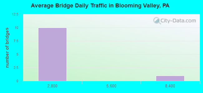
- 15,325Total average daily traffic
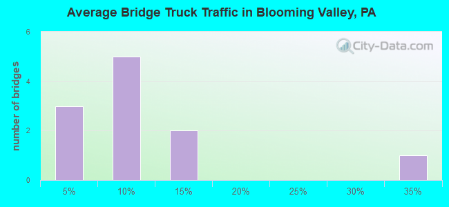
- 1,349Total average daily truck traffic
- 22,087Total future (year 2032) average daily traffic
- National Bridge Inventory (NBI) Registered Bridges for Blooming Valley
- No street view available for this location

- New bridges - historical statistics
- 11900-1909
- 11910-1919
- 11920-1929
- 11930-1939
- 21970-1979
- 42000-2009
- 12010-2019
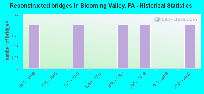
- Reconstructed bridges - Historical Statistics
- 11950-1959
- 01960-1969
- 11970-1979
- 01980-1989
- 11990-1999
- 12000-2009
- 02010-2019
- 12020-2022
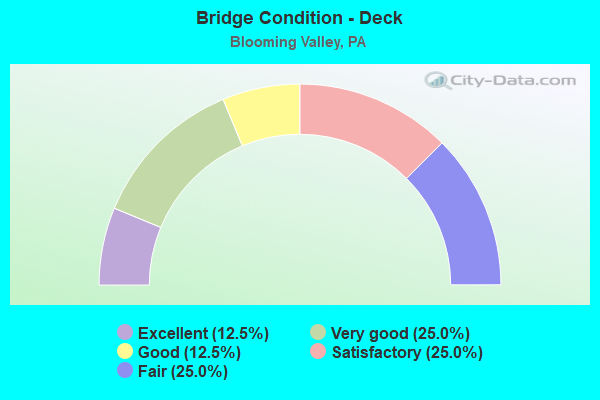
- Bridge Condition - Deck
- 12.5%Excellent
- 25.0%Very good
- 12.5%Good
- 25.0%Satisfactory
- 25.0%Fair
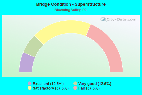
- Bridge Condition - Superstructure
- 12.5%Excellent
- 12.5%Very good
- 37.5%Satisfactory
- 37.5%Fair
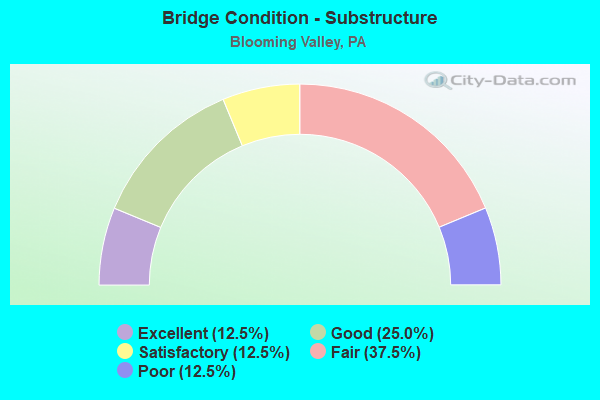
- Bridge Condition - Substructure
- 12.5%Excellent
- 25.0%Good
- 12.5%Satisfactory
- 37.5%Fair
- 12.5%Poor
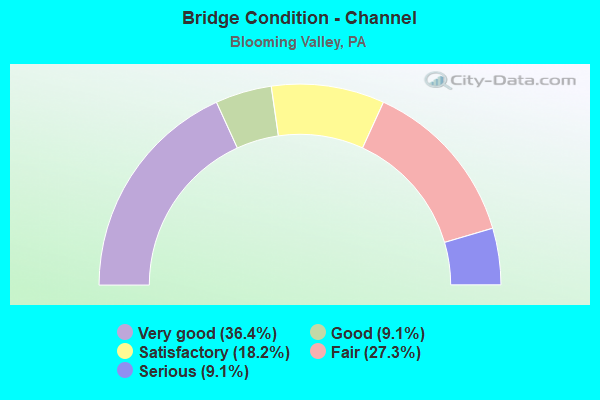
- Bridge Condition - Channel
- 36.4%Very good
- 9.1%Good
- 18.2%Satisfactory
- 27.3%Fair
- 9.1%Serious
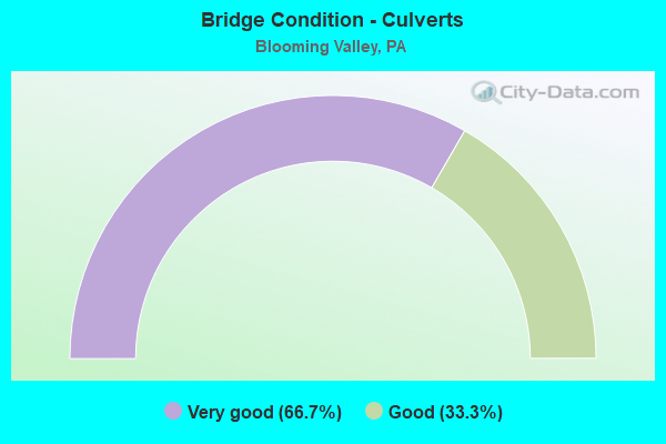
- Bridge Condition - Culverts
- 66.7%Very good
- 33.3%Good
Find on map >> Show street view
Structure Number: 12966, Location: RICHMOND TOWNSHIP (Lat: 41.696561, Lng: -80.005744), Route carried "on" structure: State highway 77, Year Built: 1917, Year Reconstructed: 1957, Status: Open, Structure Length: 0.70m (2.30ft), Average Daily Traffic: 2,110 (year 2020), Truck Traffic: 9%, Average Future Daily Traffic: 2,609 (year 2032), Design Load: H 20, Features Intersected: OVER DELMATER RUN
Minimum Vertical Clearance: 30+ m (98+ ft), Kilometerpoint: 12.600, Lanes on structure: 2, Base Highway Network: Yes, Owner: State Highway Agency, Approaching Roadway Width: 8.5m (27.9ft), Material/Design: Concrete, Design/Construction: Tee Beam, Number Of Spans In Main Unit: 1, Length of Maximum Span: 6.4m (21.0ft), Curb-To-Curb Width: 11.4m (37.4ft), Out-to-Out Width: 12.6m (41.3ft)
Condition: Deck: Fair, Superstructure: Satisfactory, Substructure: Fair, Channel: Fair, Operating Rating: 53.5 metric tons, Method Used To Determine Operating Rating: Load Factor (LF), Inventory Rating: 31.8 metric tons, Method Used To Determine Inventory Rating: Load Factor (LF), Structural Evaluation: Somewhat better than minimum adequacy, Deck Geometry: Somewhat better than minimum adequacy, Waterway Adequacy: Equal to present minimum criteria, Approach Roadway Alignment: Equal to present desirable criteria, Length Of Structure Improvement: 1.30m (4.27ft), Designated Inspection Frequency: Every 24 months, Inspection Date: September 2021, Bridge Improvement Cost: $2,000, Roadway Improvement Cost: $6,000, Total Project Cost: $26,000, Wearing Surface/Protective System: Wearing Surface: Bituminous, Membrane: Preformed Fabric
Find on map >> Show street view
Structure Number: 12967, Location: RICHMOND TOWNSHIP (Lat: 41.698681, Lng: -80.002289), Route carried "on" structure: State highway 77, Year Built: 1929, Year Reconstructed: 1981, Status: Open, Structure Length: 2.38m (7.81ft), Average Daily Traffic: 2,110 (year 2020), Truck Traffic: 9%, Average Future Daily Traffic: 2,609 (year 2032), Design Load: H 15, Features Intersected: OVER WOODCOCK CREEK TRIB
Minimum Vertical Clearance: 30+ m (98+ ft), Kilometerpoint: 12.600, Lanes on structure: 2, Base Highway Network: Yes, Owner: State Highway Agency, Approaching Roadway Width: 8.5m (27.9ft), Material/Design: Steel, Design/Construction: Girder and Floorbeam System, Number Of Spans In Main Unit: 1, Length of Maximum Span: 22.9m (75.1ft), Curb or Sidewalk Widths: Left: 1.6m (5.2ft), Right: 0.2m (0.7ft), Curb-To-Curb Width: 8.5m (27.9ft), Out-to-Out Width: 9.6m (31.5ft)
Condition: Deck: Satisfactory, Superstructure: Fair, Substructure: Fair, Channel: Satisfactory, Operating Rating: 42.6 metric tons, Method Used To Determine Operating Rating: Load Factor (LF), Inventory Rating: 25.4 metric tons, Method Used To Determine Inventory Rating: Load Factor (LF), Structural Evaluation: Somewhat better than minimum adequacy, Deck Geometry: Meets minimum limits, Waterway Adequacy: Equal to present minimum criteria, Approach Roadway Alignment: Somewhat better than minimum adequacy, Length Of Structure Improvement: 2.40m (7.87ft), Designated Inspection Frequency: Every 24 months, Critical Feature Inspection Frequency: Every 24 months, Inspection Date: November 2021, Critical Feature Inspection Date: November 2021, Bridge Improvement Cost: $7,000, Roadway Improvement Cost: $21,000, Total Project Cost: $95,000, Deck Structure Type: Concrete Cast-file-Place, Wearing Surface/Protective System: Wearing Surface: Bituminous, Membrane: Preformed Fabric, Deck Protection: Epoxy Coated Reinforcing
Find on map >> Show street view
Structure Number: 1308, Location: WOODCOCK TOWNSHIP (Lat: 41.689397, Lng: -80.052547), Route carried "on" structure: State highway 198, Year Built: 1972, Year Reconstructed: 2020, Status: Open, Structure Length: 4.88m (16.01ft), Average Daily Traffic: 2,040 (year 2022), Truck Traffic: 8%, Average Future Daily Traffic: 2,367 (year 2032), Design Load: HS 20, Features Intersected: OVER WOODCOCK CREEK
Minimum Vertical Clearance: 30+ m (98+ ft), Kilometerpoint: 41.008, Lanes on structure: 2, Base Highway Network: Yes, Owner: State Highway Agency, Approaching Roadway Width: 9.8m (32.2ft), Material/Design: Steel continuous, Design/Construction: Stringer/Multi-beam, Number Of Spans In Main Unit: 3, Length of Maximum Span: 18.3m (60.0ft), Curb or Sidewalk Widths: Left: 0.2m (0.7ft), Right: 0.2m (0.7ft), Curb-To-Curb Width: 13.0m (42.7ft), Out-to-Out Width: 14.0m (45.9ft)
Condition: Deck: Very good, Superstructure: Satisfactory, Substructure: Good, Channel: Fair, Operating Rating: 78.0 metric tons, Method Used To Determine Operating Rating: Load and Resistance Factor (LRFR), Inventory Rating: 54.4 metric tons, Method Used To Determine Inventory Rating: Load and Resistance Factor (LRFR), Structural Evaluation: Equal to present minimum criteria, Deck Geometry: Equal to present minimum criteria, Waterway Adequacy: Equal to present desirable criteria, Approach Roadway Alignment: Equal to present desirable criteria, Length Of Structure Improvement: 5.80m (19.03ft), Designated Inspection Frequency: Every 24 months, Inspection Date: September 2021, Deck Structure Type: Concrete Cast-file-Place, Wearing Surface/Protective System: Wearing Surface: Bituminous, Membrane: Preformed Fabric
Find on map >> Show street view
Structure Number: 13145, Location: WOODCOCK TOWNSHIP (Lat: 41.692264, Lng: -80.077017), Route carried "on" structure: State highway , Year Built: 1972, Year Reconstructed: 2021, Status: Open, Structure Length: 8.29m (27.20ft), Average Daily Traffic: 343 (year 2022), Truck Traffic: 10%, Average Future Daily Traffic: 1,011 (year 2032), Design Load: HL 93, Features Intersected: OVER WOODCOCK CREEK TRIB, Facility Carried by Structure: SR 1003,SHUTZ RD.
Minimum Vertical Clearance: 30+ m (98+ ft), Kilometerpoint: 6.252, Lanes on structure: 2, Owner: State Highway Agency, Approaching Roadway Width: 6.4m (21.0ft), Material/Design: Steel continuous, Design/Construction: Stringer/Multi-beam, Number Of Spans In Main Unit: 3, Length of Maximum Span: 31.4m (103.0ft), Curb or Sidewalk Widths: Left: 0.2m (0.7ft), Right: 0.2m (0.7ft), Curb-To-Curb Width: 11.6m (38.1ft), Out-to-Out Width: 12.6m (41.3ft)
Condition: Deck: Excellent, Superstructure: Satisfactory, Substructure: Satisfactory, Channel: Very good, Operating Rating: 54.8 metric tons, Method Used To Determine Operating Rating: Assigned ratings based on Load and Resistance Factor Design (LRFD) reported by rating factor (RF) using HL93 loadings, Inventory Rating: 42.1 metric tons, Method Used To Determine Inventory Rating: Assigned ratings based on Load and Resistance Factor Design (LRFD) reported by rating factor (RF) using HL93 loadings, Structural Evaluation: Equal to present minimum criteria, Deck Geometry: Superior to present desirable criteria, Waterway Adequacy: Superior to present desirable criteria, Approach Roadway Alignment: Equal to present desirable criteria, Length Of Structure Improvement: 8.30m (27.23ft), Designated Inspection Frequency: Every 24 months, Underwater Inspection Frequency: Every 60 months, Inspection Date: November 2021, Underwater Inspection Date: September 2021, Bridge Improvement Cost: $49,000, Roadway Improvement Cost: $144,000, Total Project Cost: $660,000, Deck Structure Type: Concrete Cast-file-Place, Wearing Surface/Protective System: Wearing Surface: Bituminous, Membrane: Preformed Fabric, Deck Protection: Epoxy Coated Reinforcing
Find on map >> Show street view
Structure Number: 13428, Location: 2 MI.E.SR-2009 ON T-517 (Lat: 41.632619, Lng: -80.043622), Route carried "on" structure: City street 7209, Year Built: 1905, Year Reconstructed: 2012, Status: Posted for load, Structure Length: 1.37m (4.49ft), Average Daily Traffic: 250 (year 2020), Truck Traffic: 1%, Average Future Daily Traffic: 350 (year 2040), Design Load: HS 20, Features Intersected: OVER LITTLE SUGAR CREEK, Facility Carried by Structure: T-517,PLANK ROAD
Minimum Vertical Clearance: 30+ m (98+ ft), Kilometerpoint: 0.000, Lanes on structure: 1, Owner: County Highway Agency, Approaching Roadway Width: 4.3m (14.1ft), Material/Design: Steel, Number Of Spans In Main Unit: 1, Length of Maximum Span: 13.4m (44.0ft), Curb-To-Curb Width: 4.1m (13.5ft), Out-to-Out Width: 4.2m (13.8ft)
Condition: Deck: Fair, Superstructure: Fair, Substructure: Poor, Channel: Serious, Operating Rating: 26.3 metric tons, Method Used To Determine Operating Rating: Load Factor (LF), Inventory Rating: 15.4 metric tons, Method Used To Determine Inventory Rating: Load Factor (LF), Structural Evaluation: Meets minimum limits, Deck Geometry: High priority of replacement, Waterway Adequacy: Equal to present desirable criteria, Approach Roadway Alignment: Equal to present minimum criteria, Bridge Posting: Required (Relationship of Operating Rating to Maximum Legal Load: 20.0 - 29.9% below), Length Of Structure Improvement: 1.60m (5.25ft), Designated Inspection Frequency: Every 24 months, Critical Feature Inspection Frequency: Every 12 months, Other Special Inspection Frequency: Every 12 months, Inspection Date: May 2020, Critical Feature Inspection Date: May 2021, Other Special Inspection Date: May 2021, Bridge Improvement Cost: $43,000, Roadway Improvement Cost: $264,000, Total Project Cost: $584,000, Deck Structure Type: Wood or Timber, Wearing Surface/Protective System: Wearing Surface: Wood or Timber
Find on map >> Show street view
Structure Number: 13454, Location: 4.5 MI. N. GUYS MILLS (Lat: 41.696911, Lng: -79.980492), Route carried "on" structure: City street 7217, Year Built: 1930, Year Reconstructed: 2002, Status: Open, Structure Length: 1.25m (4.10ft), Average Daily Traffic: 250 (year 2020), Truck Traffic: 1%, Average Future Daily Traffic: 313 (year 2040), Design Load: HS 25 or greater, Features Intersected: OVER WOODCOCK CREEK, Facility Carried by Structure: T-724,CASTILE ROAD
Minimum Vertical Clearance: 30+ m (98+ ft), Kilometerpoint: 0.000, Lanes on structure: 1, Owner: Town or Township Highway Agency, Approaching Roadway Width: 4.3m (14.1ft), Material/Design: Steel, Design/Construction: Stringer/Multi-beam, Number Of Spans In Main Unit: 1, Length of Maximum Span: 11.3m (37.1ft), Curb-To-Curb Width: 4.7m (15.4ft), Out-to-Out Width: 4.8m (15.7ft)
Condition: Deck: Satisfactory, Superstructure: Fair, Substructure: Fair, Channel: Fair, Operating Rating: 45.4 metric tons, Method Used To Determine Operating Rating: Load Factor (LF), Inventory Rating: 27.2 metric tons, Method Used To Determine Inventory Rating: Load Factor (LF), Structural Evaluation: Somewhat better than minimum adequacy, Deck Geometry: High priority of replacement, Waterway Adequacy: Equal to present desirable criteria, Approach Roadway Alignment: Equal to present desirable criteria, Length Of Structure Improvement: 1.60m (5.25ft), Designated Inspection Frequency: Every 24 months, Inspection Date: September 2020, Deck Structure Type: Wood or Timber, Wearing Surface/Protective System: Wearing Surface: Wood or Timber
Find on map >> Show street view
Structure Number: 4552, Location: CANAL TOWNSHIP (Lat: 41.460422, Lng: -79.932108), Route carried "on" structure: State highway , Year Built: 2009, Status: Open, Structure Length: 1.01m (3.31ft), Average Daily Traffic: 613 (year 2021), Truck Traffic: 11%, Average Future Daily Traffic: 744 (year 2032), Design Load: HL 93, Features Intersected: WARDEN RUN, Facility Carried by Structure: UTICA ROAD
Minimum Vertical Clearance: 30+ m (98+ ft), Kilometerpoint: 14.767, Lanes on structure: 2, Owner: State Highway Agency, Approaching Roadway Width: 6.1m (20.0ft), Skew: 1 degrees, Material/Design: Concrete, Design/Construction: Culvert, Number Of Spans In Main Unit: 2, Length of Maximum Span: 4.3m (14.1ft), Curb or Sidewalk Widths: Left: 0.0m, Right: 9.1m (29.9ft), Curb-To-Curb Width: 8.8m (28.9ft), Out-to-Out Width: 13.4m (44.0ft)
Condition: Channel: Very good, Culverts: Good, Operating Rating: 73.5 metric tons, Method Used To Determine Operating Rating: Load and Resistance Factor (LRFR), Inventory Rating: 56.2 metric tons, Method Used To Determine Inventory Rating: Load and Resistance Factor (LRFR), Structural Evaluation: Better than present minimum criteria, Deck Geometry: Somewhat better than minimum adequacy, Waterway Adequacy: Better than present minimum criteria, Approach Roadway Alignment: Equal to present desirable criteria, Designated Inspection Frequency: Every 48 months, Inspection Date: November 2020, Wearing Surface/Protective System: Deck Protection: Epoxy Coated Reinforcing
Find on map >> Show street view
Structure Number: 45531, Location: CLEARFIELD (Lat: 40.994658, Lng: -78.464881), Route carried "on" structure: State highway 879, Year Built: 2009, Status: Open, Structure Length: 11.19m (36.71ft), Average Daily Traffic: 7,206 (year 2021), Truck Traffic: 9%, Average Future Daily Traffic: 11,714 (year 2041), Design Load: HL 93, Features Intersected: W BR SUSQUEHANNA RIVER
Minimum Vertical Clearance: 30+ m (98+ ft), Kilometerpoint: 13.976, Lanes on structure: 2, Base Highway Network: Yes, Owner: State Highway Agency, Approaching Roadway Width: 9.4m (30.8ft), Skew: 4 degrees, Material/Design: Prestressed concrete continuous, Design/Construction: Stringer/Multi-beam, Number Of Spans In Main Unit: 3, Length of Maximum Span: 37.5m (123.0ft), Curb or Sidewalk Widths: Left: 1.5m (4.9ft), Right: 0.2m (0.7ft), Curb-To-Curb Width: 15.8m (51.8ft), Out-to-Out Width: 18.7m (61.4ft)
Condition: Deck: Good, Superstructure: Very good, Substructure: Good, Channel: Very good, Operating Rating: 75.3 metric tons, Method Used To Determine Operating Rating: Load Factor (LF), Inventory Rating: 45.4 metric tons, Method Used To Determine Inventory Rating: Load Factor (LF), Structural Evaluation: Better than present minimum criteria, Deck Geometry: Superior to present desirable criteria, Waterway Adequacy: Equal to present desirable criteria, Approach Roadway Alignment: Better than present minimum criteria, Designated Inspection Frequency: Every 24 months, Inspection Date: May 2021, Deck Structure Type: Concrete Cast-file-Place, Wearing Surface/Protective System: Wearing Surface: Monolithic Concrete, Deck Protection: Epoxy Coated Reinforcing
Find on map >> Show street view
Structure Number: 45554, Location: PIKE TWP 2M N TR 706 (Lat: 41.793306, Lng: -76.156750), Route carried "on" structure: State highway , Year Built: 2009, Status: Open, Structure Length: 0.91m (2.99ft), Average Daily Traffic: 144 (year 2019), Truck Traffic: 31%, Average Future Daily Traffic: 195 (year 2032), Design Load: HL 93, Features Intersected: MILL CREEK, Facility Carried by Structure: SR 1013
Minimum Vertical Clearance: 30+ m (98+ ft), Kilometerpoint: 0.005, Lanes on structure: 2, Owner: State Highway Agency, Approaching Roadway Width: 3.7m (12.1ft), Skew: 4 degrees, Material/Design: Concrete, Design/Construction: Culvert, Number Of Spans In Main Unit: 1, Length of Maximum Span: 8.2m (26.9ft)
Condition: Channel: Good, Culverts: Very good, Operating Rating: 68.0 metric tons, Method Used To Determine Operating Rating: Load and Resistance Factor (LRFR), Inventory Rating: 52.6 metric tons, Method Used To Determine Inventory Rating: Load and Resistance Factor (LRFR), Structural Evaluation: Equal to present desirable criteria, Waterway Adequacy: Superior to present desirable criteria, Approach Roadway Alignment: Equal to present desirable criteria, Designated Inspection Frequency: Every 48 months, Inspection Date: June 2019
Find on map >> Show street view
Structure Number: 45557, Location: 3 MI EAST OF BROOKFIELD (Lat: 41.995556, Lng: -77.554539), Route carried "on" structure: State highway , Year Built: 2009, Status: Open, Structure Length: 1.07m (3.51ft), Average Daily Traffic: 136 (year 2020), Truck Traffic: 7%, Average Future Daily Traffic: 73 (year 2032), Design Load: HL 93, Features Intersected: NORTH BROOK, Facility Carried by Structure: SR 4007
Minimum Vertical Clearance: 30+ m (98+ ft), Kilometerpoint: 9.780, Lanes on structure: 2, Owner: State Highway Agency, Approaching Roadway Width: 5.5m (18.0ft), Material/Design: Concrete, Design/Construction: Culvert, Number Of Spans In Main Unit: 1, Length of Maximum Span: 4.6m (15.1ft)
Condition: Channel: Satisfactory, Culverts: Very good, Operating Rating: 64.6 metric tons, Method Used To Determine Operating Rating: Load and Resistance Factor (LRFR), Inventory Rating: 49.8 metric tons, Method Used To Determine Inventory Rating: Load and Resistance Factor (LRFR), Structural Evaluation: Equal to present desirable criteria, Waterway Adequacy: Superior to present desirable criteria, Approach Roadway Alignment: Equal to present desirable criteria, Designated Inspection Frequency: Every 24 months, Inspection Date: June 2020
Find on map >> Show street view
Structure Number: 47977, Location: WOODCOCK TWP (Lat: 41.690739, Lng: -80.048150), Route carried "on" structure: State highway , Year Built: 2013, Status: Open, Structure Length: 3.47m (11.38ft), Average Daily Traffic: 123 (year 2017), Truck Traffic: 2%, Average Future Daily Traffic: 102 (year 2032), Design Load: HL 93, Features Intersected: WOODCOCK CREEK, Facility Carried by Structure: SR 1043,PRICE ROAD
Minimum Vertical Clearance: 30+ m (98+ ft), Kilometerpoint: 0.000, Lanes on structure: 1, Owner: State Highway Agency, Approaching Roadway Width: 6.1m (20.0ft), Material/Design: Prestressed concrete, Design/Construction: Stringer/Multi-beam, Number Of Spans In Main Unit: 1, Length of Maximum Span: 33.5m (109.9ft), Curb or Sidewalk Widths: Left: 0.2m (0.7ft), Right: 0.2m (0.7ft), Curb-To-Curb Width: 4.6m (15.1ft), Out-to-Out Width: 5.6m (18.4ft)
Condition: Deck: Very good, Superstructure: Excellent, Substructure: Excellent, Channel: Very good, Operating Rating: 66.7 metric tons, Method Used To Determine Operating Rating: Assigned ratings based on Load and Resistance Factor Design (LRFD) reported by rating factor (RF) using HL93 loadings, Inventory Rating: 34.0 metric tons, Method Used To Determine Inventory Rating: Assigned ratings based on Load and Resistance Factor Design (LRFD) reported by rating factor (RF) using HL93 loadings, Structural Evaluation: Superior to present desirable criteria, Deck Geometry: High priority of replacement, Waterway Adequacy: Equal to present desirable criteria, Approach Roadway Alignment: Equal to present minimum criteria, Designated Inspection Frequency: Every 48 months, Inspection Date: October 2019, Deck Structure Type: Concrete Cast-file-Place, Wearing Surface/Protective System: Wearing Surface: Monolithic Concrete, Deck Protection: Epoxy Coated Reinforcing