Bridge Statistics for Bloomsburg, Pennsylvania (PA)
Condition, Traffic, Stress, Structural Evaluation, Project Costs
- National Bridge Inventory (NBI) Statistics
- 19Number of bridges
- 407ft / 124mTotal length
- $8,162,000Total costs
- 192,439Total average daily traffic
- 32,990Total average daily truck traffic
- National Bridge Inventory (NBI) Registered Bridges for Bloomsburg
- No street view available for this location
- New bridges - historical statistics
- 1Before 1900
- 21930-1939
- 41960-1969
- 81970-1979
- 11980-1989
- 32000-2009
- Reconstructed bridges - Historical Statistics
- 11970-1979
- 21980-1989
- 11990-1999
- 12000-2009
- 22010-2019
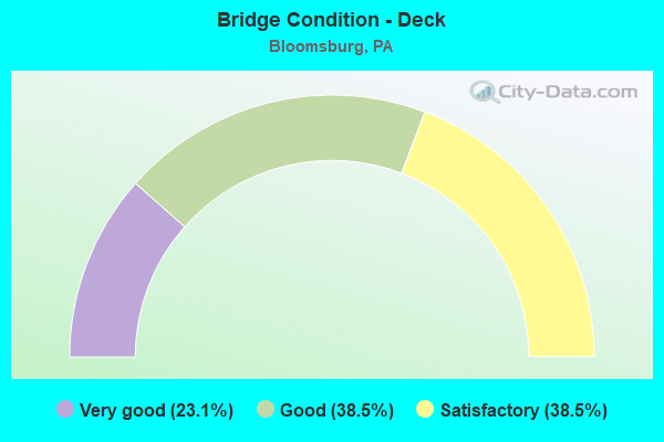
- Bridge Condition - Deck
- 23.1%Very good
- 38.5%Good
- 38.5%Satisfactory
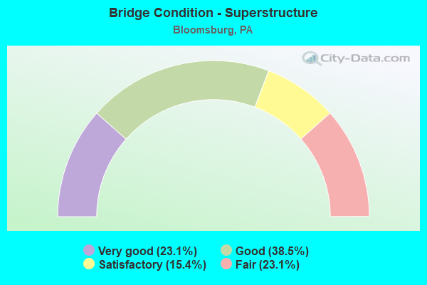
- Bridge Condition - Superstructure
- 23.1%Very good
- 38.5%Good
- 15.4%Satisfactory
- 23.1%Fair
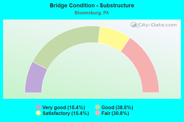
- Bridge Condition - Substructure
- 15.4%Very good
- 38.5%Good
- 15.4%Satisfactory
- 30.8%Fair
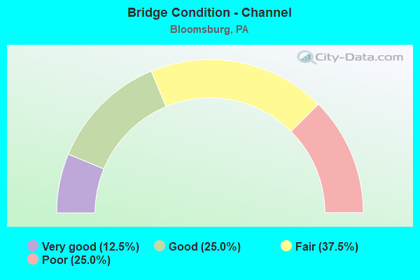
- Bridge Condition - Channel
- 12.5%Very good
- 25.0%Good
- 37.5%Fair
- 25.0%Poor
Find on map >> Show street view
Structure Number: 12441, Location: 0.5 MI W OF BLOOMSBURG (Lat: 40.989739, Lng: -76.477081), Route carried "on" structure: US 11, Year Built: 1970, Status: Open, Structure Length: 7.07m (23.20ft), Average Daily Traffic: 7,016 (year 2022), Truck Traffic: 5%, Average Future Daily Traffic: 10,960 (year 2032), Design Load: HS 20, Features Intersected: OVER FISHING CREEK
Minimum Vertical Clearance: 30+ m (98+ ft), Kilometerpoint: 4.871, Lanes on structure: 2, Base Highway Network: Yes, Owner: State Highway Agency, Approaching Roadway Width: 15.8m (51.8ft), Skew: 13 degrees, Material/Design: Steel continuous, Design/Construction: Stringer/Multi-beam, Number Of Spans In Main Unit: 2, Length of Maximum Span: 34.4m (112.9ft), Curb or Sidewalk Widths: Left: 0.2m (0.7ft), Right: 0.2m (0.7ft), Curb-To-Curb Width: 15.8m (51.8ft), Out-to-Out Width: 17.2m (56.4ft)
Condition: Deck: Good, Superstructure: Satisfactory, Substructure: Fair, Channel: Fair, Operating Rating: 48.1 metric tons, Method Used To Determine Operating Rating: Load Factor (LF), Inventory Rating: 28.1 metric tons, Method Used To Determine Inventory Rating: Load Factor (LF), Structural Evaluation: Somewhat better than minimum adequacy, Deck Geometry: Superior to present desirable criteria, Waterway Adequacy: Equal to present minimum criteria, Approach Roadway Alignment: Equal to present desirable criteria, Length Of Structure Improvement: 7.80m (25.59ft), Designated Inspection Frequency: Every 24 months, Underwater Inspection Frequency: Every 48 months, Inspection Date: July 2020, Underwater Inspection Date: July 2018, Bridge Improvement Cost: $116,000, Roadway Improvement Cost: $341,000, Total Project Cost: $1,563,000, Deck Structure Type: Concrete Cast-file-Place, Wearing Surface/Protective System: Wearing Surface: Bituminous, Membrane: Preformed Fabric
Find on map >> Show street view
Structure Number: 12443, Location: 0.5 MI W OF BLOOMSBURG (Lat: 40.989878, Lng: -76.477147), Route carried "on" structure: US 11, Year Built: 1936, Year Reconstructed: 2007, Status: Open, Structure Length: 7.07m (23.20ft), Average Daily Traffic: 7,335 (year 2022), Truck Traffic: 5%, Average Future Daily Traffic: 10,821 (year 2032), Design Load: HS 20, Features Intersected: OVER FISHING CREEK
Minimum Vertical Clearance: 30+ m (98+ ft), Kilometerpoint: 4.876, Lanes on structure: 2, Base Highway Network: Yes, Owner: State Highway Agency, Approaching Roadway Width: 11.3m (37.1ft), Skew: 13 degrees, Material/Design: Steel continuous, Design/Construction: Truss - Thru, Number Of Spans In Main Unit: 2, Length of Maximum Span: 34.1m (111.9ft), Curb or Sidewalk Widths: Left: 0.2m (0.7ft), Right: 0.2m (0.7ft), Curb-To-Curb Width: 10.0m (32.8ft), Out-to-Out Width: 11.0m (36.1ft)
Condition: Deck: Good, Superstructure: Fair, Substructure: Good, Channel: Fair, Operating Rating: 39.9 metric tons, Method Used To Determine Operating Rating: Load Factor (LF), Inventory Rating: 29.0 metric tons, Method Used To Determine Inventory Rating: Load Factor (LF), Structural Evaluation: Somewhat better than minimum adequacy, Deck Geometry: Meets minimum limits, Waterway Adequacy: Equal to present minimum criteria, Approach Roadway Alignment: Equal to present desirable criteria, Length Of Structure Improvement: 7.00m (22.97ft), Designated Inspection Frequency: Every 24 months, Critical Feature Inspection Frequency: Every 24 months, Underwater Inspection Frequency: Every 48 months, Inspection Date: July 2020, Critical Feature Inspection Date: July 2020, Underwater Inspection Date: July 2018, Bridge Improvement Cost: $5,000, Roadway Improvement Cost: $115,000, Total Project Cost: $419,000, Deck Structure Type: Concrete Cast-file-Place, Wearing Surface/Protective System: Wearing Surface: Epoxy Overlay
Find on map >> Show street view
Structure Number: 12466, Location: 1 MILE W OF BLOOMSBURG (Lat: 40.988214, Lng: -76.478567), Route carried "on" structure: State highway 42, Year Built: 1970, Year Reconstructed: 2010, Status: Open, Structure Length: 5.52m (18.11ft), Average Daily Traffic: 6,124 (year 2022), Truck Traffic: 6%, Average Future Daily Traffic: 9,978 (year 2032), Design Load: HL 93, Features Intersected: OVER US TR 11
Minimum Vertical Clearance: 30+ m (98+ ft), Kilometerpoint: 27.451, Lanes on structure: 2, Lanes under structure: 8, Owner: State Highway Agency, Approaching Roadway Width: 14.6m (47.9ft), Skew: 31 degrees, Material/Design: Prestressed concrete, Design/Construction: Stringer/Multi-beam, Number Of Spans In Main Unit: 4, Length of Maximum Span: 21.9m (71.9ft), Curb or Sidewalk Widths: Left: 0.2m (0.7ft), Right: 0.2m (0.7ft), Curb-To-Curb Width: 17.1m (56.1ft), Out-to-Out Width: 18.3m (60.0ft)
Condition: Deck: Good, Superstructure: Good, Substructure: Good, Operating Rating: 48.1 metric tons, Method Used To Determine Operating Rating: Load and Resistance Factor (LRFR), Inventory Rating: 37.2 metric tons, Method Used To Determine Inventory Rating: Load and Resistance Factor (LRFR), Structural Evaluation: Better than present minimum criteria, Deck Geometry: Superior to present desirable criteria, Underclear: Meets minimum limits, Approach Roadway Alignment: Better than present minimum criteria, Length Of Structure Improvement: 5.50m (18.04ft), Designated Inspection Frequency: Every 24 months, Inspection Date: March 2021, Bridge Improvement Cost: $73,000, Roadway Improvement Cost: $215,000, Total Project Cost: $986,000, Deck Structure Type: Concrete Cast-file-Place, Wearing Surface/Protective System: Wearing Surface: Monolithic Concrete, Deck Protection: Epoxy Coated Reinforcing
Find on map >> Show street view
Structure Number: 12467, Location: 0.5 MI W OF BLOOMSBURG (Lat: 40.988250, Lng: -76.479161), Route carried "on" structure: State highway 42, Year Built: 1970, Status: Open, Structure Length: 4.85m (15.91ft), Average Daily Traffic: 12,254 (year 2021), Truck Traffic: 4%, Average Future Daily Traffic: 16,286 (year 2032), Design Load: HS 20, Features Intersected: OVER SR 11
Minimum Vertical Clearance: 30+ m (98+ ft), Kilometerpoint: 28.057, Lanes on structure: 2, Lanes under structure: 4, Owner: State Highway Agency, Approaching Roadway Width: 13.4m (44.0ft), Skew: 30 degrees, Material/Design: Prestressed concrete, Design/Construction: Box Beam or Girders - Multiple, Number Of Spans In Main Unit: 1, Number Of Approach Spans: 2, Length of Maximum Span: 28.3m (92.8ft), Curb or Sidewalk Widths: Left: 0.2m (0.7ft), Right: 0.2m (0.7ft), Curb-To-Curb Width: 17.5m (57.4ft), Out-to-Out Width: 18.3m (60.0ft)
Condition: Deck: Satisfactory, Superstructure: Fair, Substructure: Satisfactory, Operating Rating: 65.3 metric tons, Method Used To Determine Operating Rating: Load Factor (LF), Inventory Rating: 49.9 metric tons, Method Used To Determine Inventory Rating: Load Factor (LF), Structural Evaluation: Somewhat better than minimum adequacy, Deck Geometry: Superior to present desirable criteria, Underclear: Meets minimum limits, Approach Roadway Alignment: Equal to present desirable criteria, Length Of Structure Improvement: 4.80m (15.75ft), Designated Inspection Frequency: Every 24 months, Inspection Date: Febuary 2021, Bridge Improvement Cost: $25,000, Roadway Improvement Cost: $73,000, Total Project Cost: $335,000, Deck Structure Type: Concrete Cast-file-Place, Wearing Surface/Protective System: Wearing Surface: Bituminous, Membrane: Preformed Fabric
Find on map >> Show street view
Structure Number: 12469, Location: 1 MI E OF BLOOMSBURG (Lat: 40.993464, Lng: -76.475633), Route carried "on" structure: State highway 42, Year Built: 1970, Status: Open, Structure Length: 6.04m (19.82ft), Average Daily Traffic: 12,254 (year 2021), Truck Traffic: 4%, Average Future Daily Traffic: 14,694 (year 2032), Design Load: HS 20, Features Intersected: OVER FISHING CREEK
Minimum Vertical Clearance: 30+ m (98+ ft), Kilometerpoint: 28.188, Lanes on structure: 2, Owner: State Highway Agency, Approaching Roadway Width: 15.2m (49.9ft), Skew: 30 degrees, Material/Design: Prestressed concrete, Design/Construction: Stringer/Multi-beam, Number Of Spans In Main Unit: 2, Length of Maximum Span: 29.3m (96.1ft), Curb or Sidewalk Widths: Left: 0.2m (0.7ft), Right: 0.2m (0.7ft), Curb-To-Curb Width: 21.9m (71.9ft), Out-to-Out Width: 23.2m (76.1ft)
Condition: Deck: Satisfactory, Superstructure: Good, Substructure: Fair, Channel: Poor, Inventory Rating: 31.8 metric tons, Method Used To Determine Inventory Rating: Load Factor (LF), Structural Evaluation: Somewhat better than minimum adequacy, Deck Geometry: Superior to present desirable criteria, Waterway Adequacy: Superior to present desirable criteria, Approach Roadway Alignment: Equal to present desirable criteria, Length Of Structure Improvement: 3.00m (9.84ft), Designated Inspection Frequency: Every 24 months, Underwater Inspection Frequency: Every 24 months, Inspection Date: July 2020, Underwater Inspection Date: July 2020, Deck Structure Type: Concrete Cast-file-Place, Wearing Surface/Protective System: Wearing Surface: Bituminous, Membrane: Preformed Fabric
Find on map >> Show street view
Structure Number: 12497, Location: 2 MILES E OF BUCKHORN (Lat: 41.018122, Lng: -76.475908), Route carried "on" structure: Interstate 80, Year Built: 1965, Year Reconstructed: 2010, Status: Open, Structure Length: 15.54m (50.98ft), Average Daily Traffic: 19,499 (year 2021), Truck Traffic: 28%, Average Future Daily Traffic: 25,086 (year 2032), Design Load: HL 93, Features Intersected: OVER FISHING CR AND T360
Minimum Vertical Clearance: 30+ m (98+ ft), Kilometerpoint: 7.783, Lanes on structure: 2, Lanes under structure: 2, Base Highway Network: Yes, Owner: State Highway Agency, Approaching Roadway Width: 10.7m (35.1ft), Skew: 13 degrees, Material/Design: Steel continuous, Design/Construction: Stringer/Multi-beam, Number Of Spans In Main Unit: 4, Length of Maximum Span: 43.0m (141.1ft), Curb or Sidewalk Widths: Left: 0.2m (0.7ft), Right: 0.2m (0.7ft), Curb-To-Curb Width: 10.3m (33.8ft), Out-to-Out Width: 11.4m (37.4ft)
Condition: Deck: Very good, Superstructure: Very good, Substructure: Good, Channel: Very good, Operating Rating: 65.3 metric tons, Method Used To Determine Operating Rating: Load and Resistance Factor (LRFR), Inventory Rating: 50.8 metric tons, Method Used To Determine Inventory Rating: Load and Resistance Factor (LRFR), Structural Evaluation: Better than present minimum criteria, Deck Geometry: Meets minimum limits, Underclear: Equal to present minimum criteria, Waterway Adequacy: Superior to present desirable criteria, Approach Roadway Alignment: Equal to present desirable criteria, Length Of Structure Improvement: 15.50m (50.85ft), Designated Inspection Frequency: Every 48 months, Inspection Date: April 2020, Bridge Improvement Cost: $217,000, Roadway Improvement Cost: $639,000, Total Project Cost: $2,928,000, Deck Structure Type: Concrete Cast-file-Place, Wearing Surface/Protective System: Wearing Surface: Epoxy Overlay, Deck Protection: Epoxy Coated Reinforcing
Find on map >> Show street view
Structure Number: 12498, Location: TOWN OF BLOOMSBURG (Lat: 41.020267, Lng: -76.471219), Route carried "on" structure: Interstate 80, Year Built: 1965, Year Reconstructed: 1992, Status: Open, Structure Length: 3.29m (10.79ft), Average Daily Traffic: 19,499 (year 2021), Truck Traffic: 28%, Average Future Daily Traffic: 30,525 (year 2032), Design Load: HS 20+Mod, Features Intersected: OVER SR 4009
Minimum Vertical Clearance: 30+ m (98+ ft), Kilometerpoint: 7.783, Lanes on structure: 2, Lanes under structure: 2, Base Highway Network: Yes, Owner: State Highway Agency, Approaching Roadway Width: 11.9m (39.0ft), Skew: 10 degrees, Material/Design: Prestressed concrete continuous, Design/Construction: Box Beam or Girders - Single/Spread, Number Of Spans In Main Unit: 3, Length of Maximum Span: 13.4m (44.0ft), Curb or Sidewalk Widths: Left: 0.2m (0.7ft), Right: 0.2m (0.7ft), Curb-To-Curb Width: 12.8m (42.0ft), Out-to-Out Width: 13.7m (44.9ft)
Condition: Deck: Satisfactory, Superstructure: Good, Substructure: Satisfactory, Operating Rating: 69.9 metric tons, Method Used To Determine Operating Rating: Load Factor (LF), Inventory Rating: 41.7 metric tons, Method Used To Determine Inventory Rating: Load Factor (LF), Structural Evaluation: Equal to present minimum criteria, Deck Geometry: Equal to present desirable criteria, Underclear: Equal to present minimum criteria, Approach Roadway Alignment: Equal to present desirable criteria, Length Of Structure Improvement: 3.30m (10.83ft), Designated Inspection Frequency: Every 48 months, Inspection Date: Febuary 2019, Deck Structure Type: Concrete Cast-file-Place, Wearing Surface/Protective System: Wearing Surface: Epoxy Overlay, Deck Protection: Epoxy Coated Reinforcing
Find on map >> Show street view
Structure Number: 12501, Location: 0.5 MILE W OF LIGHTSTREET (Lat: 41.026744, Lng: -76.442497), Route carried "on" structure: Interstate 80, Year Built: 1963, Year Reconstructed: 1992, Status: Open, Structure Length: 6.55m (21.49ft), Average Daily Traffic: 19,499 (year 2021), Truck Traffic: 28%, Average Future Daily Traffic: 25,086 (year 2032), Design Load: HS 20+Mod, Features Intersected: OVER TWP RD T-488
Minimum Vertical Clearance: 30+ m (98+ ft), Kilometerpoint: 10.258, Lanes on structure: 2, Lanes under structure: 2, Base Highway Network: Yes, Owner: State Highway Agency, Approaching Roadway Width: 10.4m (34.1ft), Skew: 14 degrees, Material/Design: Prestressed concrete continuous, Design/Construction: Box Beam or Girders - Single/Spread, Number Of Spans In Main Unit: 4, Length of Maximum Span: 19.5m (64.0ft), Curb or Sidewalk Widths: Left: 0.2m (0.7ft), Right: 0.2m (0.7ft), Curb-To-Curb Width: 10.4m (34.1ft), Out-to-Out Width: 11.4m (37.4ft)
Condition: Deck: Satisfactory, Superstructure: Satisfactory, Substructure: Fair, Operating Rating: 68.9 metric tons, Method Used To Determine Operating Rating: Load Factor (LF), Inventory Rating: 37.2 metric tons, Method Used To Determine Inventory Rating: Load Factor (LF), Structural Evaluation: Somewhat better than minimum adequacy, Deck Geometry: Meets minimum limits, Underclear: Equal to present minimum criteria, Approach Roadway Alignment: Equal to present desirable criteria, Length Of Structure Improvement: 6.60m (21.65ft), Designated Inspection Frequency: Every 24 months, Inspection Date: Febuary 2021, Bridge Improvement Cost: $12,000, Roadway Improvement Cost: $35,000, Total Project Cost: $161,000, Deck Structure Type: Concrete Cast-file-Place, Wearing Surface/Protective System: Wearing Surface: Epoxy Overlay, Deck Protection: Epoxy Coated Reinforcing
Find on map >> Show street view
Structure Number: 12585, Location: EAST BLOOMSBURG RIVER BR. (Lat: 40.992278, Lng: -76.439058), Route carried "on" structure: State highway 487, Year Built: 1987, Status: Open, Structure Length: 41.03m (134.61ft), Average Daily Traffic: 7,570 (year 2022), Truck Traffic: 6%, Average Future Daily Traffic: 11,055 (year 2032), Design Load: HS 25 or greater, Features Intersected: D&H RR,NB SUSQUEHANNA R.
Minimum Vertical Clearance: 30+ m (98+ ft), Kilometerpoint: 16.190, Lanes on structure: 2, Owner: State Highway Agency, Approaching Roadway Width: 9.1m (29.9ft), Material/Design: Prestressed concrete continuous, Design/Construction: Stringer/Multi-beam, Number Of Spans In Main Unit: 10, Length of Maximum Span: 41.1m (134.8ft), Curb or Sidewalk Widths: Left: 1.8m (5.9ft), Right: 0.0m, Curb-To-Curb Width: 11.0m (36.1ft), Out-to-Out Width: 13.6m (44.6ft)
Condition: Deck: Good, Superstructure: Good, Substructure: Good, Channel: Fair, Operating Rating: 78.0 metric tons, Method Used To Determine Operating Rating: Load Factor (LF), Inventory Rating: 15.4 metric tons, Method Used To Determine Inventory Rating: Load Factor (LF), Structural Evaluation: High priority of corrective action, Deck Geometry: Meets minimum limits, Underclear: High priority of corrective action, Waterway Adequacy: Equal to present desirable criteria, Approach Roadway Alignment: Equal to present desirable criteria, Length Of Structure Improvement: 41.60m (136.48ft), Designated Inspection Frequency: Every 24 months, Underwater Inspection Frequency: Every 24 months, Inspection Date: April 2020, Underwater Inspection Date: July 2021, Deck Structure Type: Concrete Cast-file-Place, Wearing Surface/Protective System: Wearing Surface: Epoxy Overlay, Deck Protection: Epoxy Coated Reinforcing
Find on map >> Show street view
Structure Number: 12713, Location: TOWN OF BLOOMSBURG (Lat: 41.022183, Lng: -76.473611), Route carried "on" structure: State highway , Year Built: 1930, Year Reconstructed: 1977, Status: Open, Structure Length: 4.85m (15.91ft), Average Daily Traffic: 5,310 (year 2020), Truck Traffic: 4%, Average Future Daily Traffic: 8,188 (year 2032), Features Intersected: FISHING CREEK, Facility Carried by Structure: 4009-MILLVILLE RD
Minimum Vertical Clearance: 4.55m (14.93ft), Kilometerpoint: 2.663, Lanes on structure: 2, Owner: State Highway Agency, Approaching Roadway Width: 9.1m (29.9ft), Material/Design: Steel, Design/Construction: Truss - Thru, Number Of Spans In Main Unit: 1, Length of Maximum Span: 46.9m (153.9ft), Curb or Sidewalk Widths: Left: 0.2m (0.7ft), Right: 0.2m (0.7ft), Curb-To-Curb Width: 6.6m (21.7ft), Out-to-Out Width: 7.4m (24.3ft)
Condition: Deck: Satisfactory, Superstructure: Fair, Substructure: Fair, Channel: Poor, Operating Rating: 61.7 metric tons, Method Used To Determine Operating Rating: Load Factor (LF), Inventory Rating: 34.5 metric tons, Method Used To Determine Inventory Rating: Load Factor (LF), Structural Evaluation: Somewhat better than minimum adequacy, Deck Geometry: High priority of replacement, Waterway Adequacy: Equal to present minimum criteria, Approach Roadway Alignment: Equal to present desirable criteria, Length Of Structure Improvement: 5.10m (16.73ft), Designated Inspection Frequency: Every 24 months, Critical Feature Inspection Frequency: Every 24 months, Inspection Date: June 2020, Critical Feature Inspection Date: June 2020, Bridge Improvement Cost: $131,000, Roadway Improvement Cost: $386,000, Total Project Cost: $1,770,000, Deck Structure Type: Concrete Cast-file-Place, Wearing Surface/Protective System: Wearing Surface: Epoxy Overlay
Find on map >> Show street view
Structure Number: 12864, Location: 0.2 MI. NNE OF RUPERT (Lat: 40.981308, Lng: -76.472556), Route carried "on" structure: City street , Year Built: 1847, Year Reconstructed: 2001, Status: Open, Structure Length: 5.18m (16.99ft), Average Daily Traffic: 375 (year 2021), Truck Traffic: 6%, Average Future Daily Traffic: 1,911 (year 2043), Design Load: H 20, Features Intersected: FISHING CREEK, Facility Carried by Structure: CTY BR 56
Minimum Vertical Clearance: 2.90m (9.51ft), Kilometerpoint: 0.000, Lanes on structure: 1, Owner: County Highway Agency, Approaching Roadway Width: 7.3m (24.0ft), Material/Design: Steel continuous, Design/Construction: Stringer/Multi-beam, Number Of Spans In Main Unit: 3, Length of Maximum Span: 17.1m (56.1ft), Curb or Sidewalk Widths: Left: 0.2m (0.7ft), Right: 0.2m (0.7ft), Curb-To-Curb Width: 4.6m (15.1ft), Out-to-Out Width: 5.2m (17.1ft)
Condition: Deck: Very good, Superstructure: Very good, Substructure: Good, Channel: Good, Operating Rating: 68.9 metric tons, Method Used To Determine Operating Rating: Load Factor (LF), Inventory Rating: 40.8 metric tons, Method Used To Determine Inventory Rating: Load Factor (LF), Structural Evaluation: Better than present minimum criteria, Deck Geometry: High priority of replacement, Waterway Adequacy: Equal to present minimum criteria, Approach Roadway Alignment: Somewhat better than minimum adequacy, Length Of Structure Improvement: 5.20m (17.06ft), Designated Inspection Frequency: Every 24 months, Underwater Inspection Frequency: Every 48 months, Inspection Date: September 2021, Underwater Inspection Date: September 2019, Deck Structure Type: Wood or Timber, Wearing Surface/Protective System: Wearing Surface: Wood or Timber
Find on map >> Show street view
Structure Number: 45784, Location: 2 MI EAST OF BUCKHORN (Lat: 41.017950, Lng: -76.475700), Route carried "on" structure: Interstate 80, Year Built: 2009, Status: Open, Structure Length: 15.36m (50.39ft), Average Daily Traffic: 18,191 (year 2021), Truck Traffic: 33%, Average Future Daily Traffic: 25,251 (year 2032), Design Load: HL 93, Features Intersected: FISHING CR & T-360
Minimum Vertical Clearance: 30.18m (99.02ft), Kilometerpoint: 7.800, Lanes on structure: 2, Lanes under structure: 2, Base Highway Network: Yes, Owner: State Highway Agency, Approaching Roadway Width: 10.4m (34.1ft), Skew: 13 degrees, Material/Design: Prestressed concrete, Design/Construction: Stringer/Multi-beam, Number Of Spans In Main Unit: 4, Length of Maximum Span: 42.1m (138.1ft), Curb or Sidewalk Widths: Left: 0.2m (0.7ft), Right: 0.2m (0.7ft), Curb-To-Curb Width: 14.0m (45.9ft), Out-to-Out Width: 15.1m (49.5ft)
Condition: Deck: Good, Superstructure: Good, Substructure: Very good, Channel: Good, Operating Rating: 78.9 metric tons, Method Used To Determine Operating Rating: Load and Resistance Factor (LRFR), Inventory Rating: 44.5 metric tons, Method Used To Determine Inventory Rating: Load and Resistance Factor (LRFR), Structural Evaluation: Better than present minimum criteria, Deck Geometry: Superior to present desirable criteria, Underclear: Superior to present desirable criteria, Waterway Adequacy: Superior to present desirable criteria, Approach Roadway Alignment: Equal to present desirable criteria, Designated Inspection Frequency: Every 24 months, Inspection Date: April 2020, Deck Structure Type: Concrete Cast-file-Place, Wearing Surface/Protective System: Wearing Surface: Epoxy Overlay, Deck Protection: Epoxy Coated Reinforcing
Find on map >> Show street view
Structure Number: 45785, Location: BLOOMSBURG (Lat: 41.020069, Lng: -76.471047), Route carried "on" structure: Interstate 80, Year Built: 2009, Status: Open, Structure Length: 2.04m (6.69ft), Average Daily Traffic: 18,191 (year 2021), Truck Traffic: 33%, Average Future Daily Traffic: 30,726 (year 2032), Design Load: HL 93, Features Intersected: SR 4009
Minimum Vertical Clearance: 30+ m (98+ ft), Kilometerpoint: 7.800, Lanes on structure: 2, Lanes under structure: 2, Base Highway Network: Yes, Owner: State Highway Agency, Approaching Roadway Width: 12.2m (40.0ft), Skew: 10 degrees, Material/Design: Prestressed concrete, Design/Construction: Box Beam or Girders - Single/Spread, Number Of Spans In Main Unit: 1, Length of Maximum Span: 19.8m (65.0ft), Curb or Sidewalk Widths: Left: 0.2m (0.7ft), Right: 0.2m (0.7ft), Curb-To-Curb Width: 14.4m (47.2ft), Out-to-Out Width: 15.4m (50.5ft)
Condition: Deck: Very good, Superstructure: Very good, Substructure: Very good, Operating Rating: 66.2 metric tons, Method Used To Determine Operating Rating: Load and Resistance Factor (LRFR), Inventory Rating: 46.3 metric tons, Method Used To Determine Inventory Rating: Load and Resistance Factor (LRFR), Structural Evaluation: Equal to present desirable criteria, Deck Geometry: Superior to present desirable criteria, Underclear: Equal to present minimum criteria, Approach Roadway Alignment: Equal to present desirable criteria, Designated Inspection Frequency: Every 48 months, Inspection Date: Febuary 2019, Deck Structure Type: Concrete Cast-file-Place, Wearing Surface/Protective System: Wearing Surface: Epoxy Overlay, Deck Protection: Epoxy Coated Reinforcing
Find on map >> Show street view
Structure Number: 12466, Location: 1 MILE W OF BLOOMSBURG (Lat: 40.988214, Lng: -76.478567), Route carried "under" structure: US 11, Year Built: 1970, Structure Length: 0. m, Average Daily Traffic: 7,016 (year 2022), Truck Traffic: 5%, Features Intersected: OVER US TR 11, Facility Carried by Structure: SR 0042
Minimum Vertical Clearance: 4.50m (14.76ft), Kilometerpoint: 4.342, Lanes on structure: 2, Lanes under structure: 4, Material/Design: Prestressed concrete, Design/Construction: Stringer/Multi-beam, Length of Maximum Span: 21.9m (71.9ft)
Find on map >> Show street view
Structure Number: 12466, Location: 1 MILE W OF BLOOMSBURG (Lat: 40.988214, Lng: -76.478567), Route carried "under" structure: US 11, Year Built: 1970, Structure Length: 0. m, Average Daily Traffic: 7,335 (year 2022), Truck Traffic: 5%, Features Intersected: OVER US TR 11, Facility Carried by Structure: SR 0042
Minimum Vertical Clearance: 4.50m (14.76ft), Kilometerpoint: 4.340, Lanes on structure: 2, Lanes under structure: 4, Material/Design: Prestressed concrete, Design/Construction: Stringer/Multi-beam, Length of Maximum Span: 21.9m (71.9ft)
Find on map >> Show street view
Structure Number: 12467, Location: 0.5 MI W OF BLOOMSBURG (Lat: 40.988250, Lng: -76.479161), Route carried "under" structure: US 11, Year Built: 1970, Structure Length: 0. m, Average Daily Traffic: 7,016 (year 2022), Truck Traffic: 5%, Features Intersected: OVER SR 11, Facility Carried by Structure: SR 42
Minimum Vertical Clearance: 4.29m (14.07ft), Kilometerpoint: 5.312, Lanes on structure: 2, Lanes under structure: 2, Material/Design: Prestressed concrete, Design/Construction: Box Beam or Girders - Multiple, Length of Maximum Span: 28.3m (92.8ft)
Find on map >> Show street view
Structure Number: 12467, Location: 0.5 MI W OF BLOOMSBURG (Lat: 40.988250, Lng: -76.479161), Route carried "under" structure: US 11, Year Built: 1970, Structure Length: 0. m, Average Daily Traffic: 7,335 (year 2022), Truck Traffic: 5%, Features Intersected: OVER SR 11, Facility Carried by Structure: SR 42
Minimum Vertical Clearance: 4.47m (14.67ft), Kilometerpoint: 5.308, Lanes on structure: 2, Lanes under structure: 2, Material/Design: Prestressed concrete, Design/Construction: Box Beam or Girders - Multiple, Length of Maximum Span: 28.3m (92.8ft)
Find on map >> Show street view
Structure Number: 12498, Location: TOWN OF BLOOMSBURG (Lat: 41.020267, Lng: -76.471219), Route carried "under" structure: State highway , Year Built: 1965, Structure Length: 0. m, Average Daily Traffic: 5,310 (year 2020), Truck Traffic: 4%, Features Intersected: OVER SR 4009, Facility Carried by Structure: SR-80 WBL
Minimum Vertical Clearance: 4.52m (14.83ft), Kilometerpoint: 2.060, Lanes on structure: 2, Lanes under structure: 2, Material/Design: Prestressed concrete continuous, Design/Construction: Box Beam or Girders - Single/Spread, Length of Maximum Span: 13.4m (44.0ft)
Find on map >> Show street view
Structure Number: 45785, Location: BLOOMSBURG (Lat: 41.020069, Lng: -76.471047), Route carried "under" structure: State highway , Year Built: 2009, Structure Length: 0. m, Average Daily Traffic: 5,310 (year 2020), Truck Traffic: 4%, Features Intersected: SR 4009, Facility Carried by Structure: I 80 EB
Minimum Vertical Clearance: 30+ m (98+ ft), Kilometerpoint: 2.060, Lanes on structure: 2, Lanes under structure: 2, Material/Design: Prestressed concrete, Design/Construction: Box Beam or Girders - Single/Spread, Length of Maximum Span: 19.8m (65.0ft)