Bridge Statistics for Blue Bell, Pennsylvania (PA)
Condition, Traffic, Stress, Structural Evaluation, Project Costs
- National Bridge Inventory (NBI) Statistics
- 22Number of bridges
- 125ft / 37.5mTotal length
- $1,299,000Total costs
- 549,384Total average daily traffic
- 68,877Total average daily truck traffic
- National Bridge Inventory (NBI) Registered Bridges for Blue Bell
- No street view available for this location
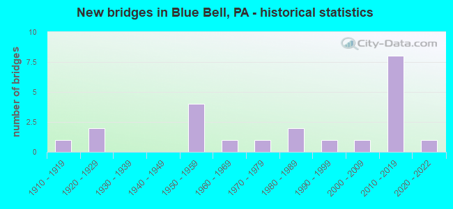
- New bridges - historical statistics
- 11910-1919
- 21920-1929
- 41950-1959
- 11960-1969
- 11970-1979
- 21980-1989
- 11990-1999
- 12000-2009
- 82010-2019
- 12020-2022
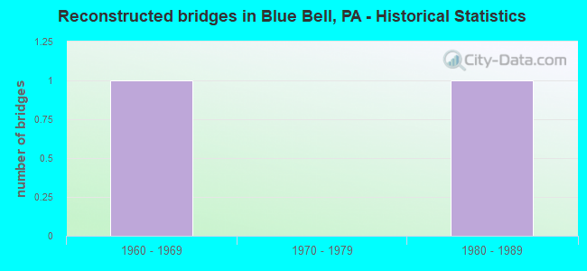
- Reconstructed bridges - Historical Statistics
- 11960-1969
- 01970-1979
- 11980-1989
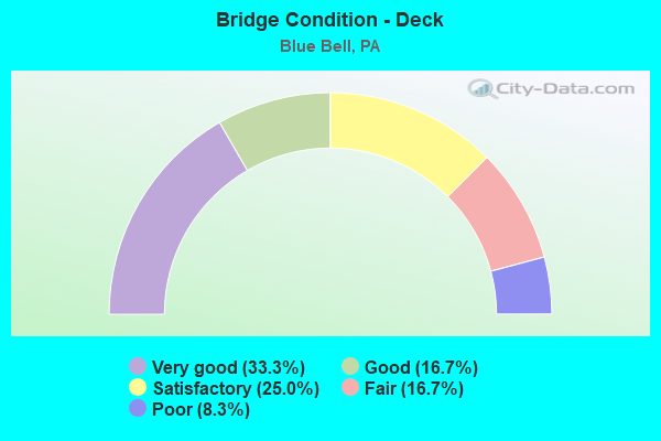
- Bridge Condition - Deck
- 33.3%Very good
- 16.7%Good
- 25.0%Satisfactory
- 16.7%Fair
- 8.3%Poor
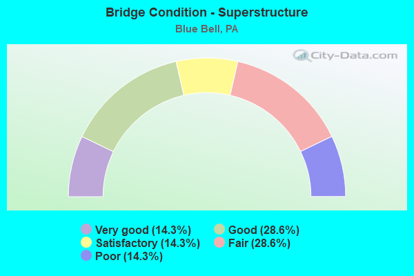
- Bridge Condition - Superstructure
- 14.3%Very good
- 28.6%Good
- 14.3%Satisfactory
- 28.6%Fair
- 14.3%Poor
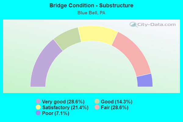
- Bridge Condition - Substructure
- 28.6%Very good
- 14.3%Good
- 21.4%Satisfactory
- 28.6%Fair
- 7.1%Poor
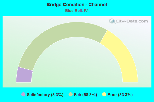
- Bridge Condition - Channel
- 8.3%Satisfactory
- 58.3%Fair
- 33.3%Poor
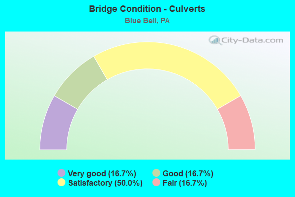
- Bridge Condition - Culverts
- 16.7%Very good
- 16.7%Good
- 50.0%Satisfactory
- 16.7%Fair
Find on map >> Show street view
Structure Number: 27205, Location: BETHEL HILL 22E10/3256A2 (Lat: 40.177289, Lng: -75.307269), Route carried "on" structure: State highway 73, Year Built: 1950, Status: Open, Structure Length: 0.67m (2.20ft), Average Daily Traffic: 13,599 (year 2022), Truck Traffic: 5%, Average Future Daily Traffic: 18,608 (year 2032), Design Load: HS 20, Features Intersected: STONY CREEK, Facility Carried by Structure: SKIPPACK PIKE
Minimum Vertical Clearance: 30+ m (98+ ft), Kilometerpoint: 30.981, Lanes on structure: 2, Base Highway Network: Yes, Owner: State Highway Agency, Approaching Roadway Width: 11.9m (39.0ft), Material/Design: Concrete, Design/Construction: Tee Beam, Number Of Spans In Main Unit: 1, Length of Maximum Span: 6.4m (21.0ft), Curb or Sidewalk Widths: Left: 1.5m (4.9ft), Right: 1.5m (4.9ft), Curb-To-Curb Width: 11.8m (38.7ft), Out-to-Out Width: 16.8m (55.1ft)
Condition: Deck: Satisfactory, Superstructure: Satisfactory, Substructure: Fair, Channel: Poor, Operating Rating: 57.2 metric tons, Method Used To Determine Operating Rating: Load Factor (LF), Inventory Rating: 34.5 metric tons, Method Used To Determine Inventory Rating: Load Factor (LF), Structural Evaluation: Somewhat better than minimum adequacy, Deck Geometry: Somewhat better than minimum adequacy, Waterway Adequacy: Equal to present minimum criteria, Approach Roadway Alignment: Equal to present desirable criteria, Length Of Structure Improvement: 1.30m (4.27ft), Designated Inspection Frequency: Every 24 months, Inspection Date: Febuary 2021, Deck Structure Type: Concrete Cast-file-Place, Wearing Surface/Protective System: Wearing Surface: Bituminous
Find on map >> Show street view
Structure Number: 27206, Location: CENTER SQ. 22H12/3256D4 (Lat: 40.167467, Lng: -75.291031), Route carried "on" structure: State highway 73, Year Built: 1950, Status: Open, Structure Length: 0.70m (2.30ft), Average Daily Traffic: 13,599 (year 2022), Truck Traffic: 5%, Average Future Daily Traffic: 18,608 (year 2032), Design Load: H 20, Features Intersected: BRANCH STONY RUN, Facility Carried by Structure: SKIPPACK PIKE
Minimum Vertical Clearance: 30+ m (98+ ft), Kilometerpoint: 32.398, Lanes on structure: 2, Base Highway Network: Yes, Owner: State Highway Agency, Approaching Roadway Width: 12.8m (42.0ft), Skew: 1 degrees, Material/Design: Concrete, Design/Construction: Tee Beam, Number Of Spans In Main Unit: 1, Length of Maximum Span: 6.7m (22.0ft), Curb or Sidewalk Widths: Left: 2.1m (6.9ft), Right: 2.1m (6.9ft), Curb-To-Curb Width: 11.7m (38.4ft), Out-to-Out Width: 15.8m (51.8ft)
Condition: Deck: Satisfactory, Superstructure: Satisfactory, Substructure: Fair, Channel: Fair, Operating Rating: 57.2 metric tons, Method Used To Determine Operating Rating: Load Factor (LF), Inventory Rating: 33.6 metric tons, Method Used To Determine Inventory Rating: Load Factor (LF), Structural Evaluation: Somewhat better than minimum adequacy, Deck Geometry: Somewhat better than minimum adequacy, Waterway Adequacy: Equal to present minimum criteria, Approach Roadway Alignment: Equal to present desirable criteria, Length Of Structure Improvement: 1.30m (4.27ft), Designated Inspection Frequency: Every 24 months, Inspection Date: Febuary 2021, Bridge Improvement Cost: $10,000, Roadway Improvement Cost: $28,000, Total Project Cost: $130,000, Deck Structure Type: Concrete Cast-file-Place, Wearing Surface/Protective System: Wearing Surface: Bituminous
Find on map >> Show street view
Structure Number: 27339, Location: N OF PA 73 22H12/3256D4 (Lat: 40.168008, Lng: -75.289178), Route carried "on" structure: US 202, Year Built: 1922, Year Reconstructed: 1972, Status: Open, Structure Length: 0.67m (2.20ft), Average Daily Traffic: 20,667 (year 2022), Truck Traffic: 5%, Average Future Daily Traffic: 27,480 (year 2032), Design Load: H 15, Features Intersected: BRANCH STONY CREEK, Facility Carried by Structure: DEKALB PIKE
Minimum Vertical Clearance: 30+ m (98+ ft), Kilometerpoint: 14.497, Lanes on structure: 4, Base Highway Network: Yes, Owner: State Highway Agency, Approaching Roadway Width: 16.8m (55.1ft), Skew: 3 degrees, Material/Design: Concrete, Design/Construction: Slab, Number Of Spans In Main Unit: 1, Length of Maximum Span: 6.4m (21.0ft), Curb or Sidewalk Widths: Left: 0.0m, Right: 2.4m (7.9ft), Curb-To-Curb Width: 15.5m (50.9ft), Out-to-Out Width: 17.0m (55.8ft)
Condition: Deck: Fair, Superstructure: Fair, Substructure: Fair, Channel: Poor, Culverts: Satisfactory, Operating Rating: 62.6 metric tons, Method Used To Determine Operating Rating: Load Factor (LF), Inventory Rating: 37.2 metric tons, Method Used To Determine Inventory Rating: Load Factor (LF), Structural Evaluation: Somewhat better than minimum adequacy, Deck Geometry: Meets minimum limits, Waterway Adequacy: Equal to present minimum criteria, Approach Roadway Alignment: Equal to present desirable criteria, Length Of Structure Improvement: 1.20m (3.94ft), Designated Inspection Frequency: Every 24 months, Inspection Date: Febuary 2021, Bridge Improvement Cost: $5,000, Roadway Improvement Cost: $15,000, Total Project Cost: $68,000, Wearing Surface/Protective System: Wearing Surface: Bituminous
Find on map >> Show street view
Structure Number: 27341, Location: 1MI.N.MONT CO CC 23A08 (Lat: 40.187922, Lng: -75.268222), Route carried "on" structure: US 202, Year Built: 1922, Status: Posted for load, Structure Length: 1.62m (5.31ft), Average Daily Traffic: 18,560 (year 2022), Truck Traffic: 5%, Average Future Daily Traffic: 25,309 (year 2032), Design Load: H 15, Features Intersected: WISSAHICKON CREEK, Facility Carried by Structure: DEKALB PIKE
Minimum Vertical Clearance: 30+ m (98+ ft), Kilometerpoint: 17.188, Lanes on structure: 2, Base Highway Network: Yes, Owner: State Highway Agency, Approaching Roadway Width: 15.2m (49.9ft), Skew: 1 degrees, Material/Design: Masonry, Design/Construction: Arch - Deck, Number Of Spans In Main Unit: 2, Length of Maximum Span: 8.5m (27.9ft), Curb-To-Curb Width: 10.2m (33.5ft), Out-to-Out Width: 11.0m (36.1ft)
Condition: Superstructure: Poor, Substructure: Poor, Channel: Poor, Operating Rating: 49.9 metric tons, Method Used To Determine Operating Rating: Field evaluation and documented engineering judgment, Inventory Rating: 24.5 metric tons, Method Used To Determine Inventory Rating: Field evaluation and documented engineering judgment, Structural Evaluation: Meets minimum limits, Deck Geometry: Meets minimum limits, Waterway Adequacy: Equal to present minimum criteria, Approach Roadway Alignment: Equal to present desirable criteria, Length Of Structure Improvement: 2.10m (6.89ft), Designated Inspection Frequency: Every 24 months, Other Special Inspection Frequency: Every 12 months, Inspection Date: April 2021, Other Special Inspection Date: April 2021, Bridge Improvement Cost: $11,000, Roadway Improvement Cost: $33,000, Total Project Cost: $150,000
Find on map >> Show street view
Structure Number: 27978, Location: 0.4MI NW OR SR0202 22K08 (Lat: 40.186706, Lng: -75.278567), Route carried "on" structure: City street , Year Built: 1910, Status: Open, Structure Length: 1.34m (4.40ft), Average Daily Traffic: 1,944 (year 2019), Average Future Daily Traffic: 1,441 (year 2018), Features Intersected: WISSAHICKON CREEK, Facility Carried by Structure: SWEDESFORD ROAD
Minimum Vertical Clearance: 30+ m (98+ ft), Kilometerpoint: 0.000, Lanes on structure: 2, Owner: County Highway Agency, Approaching Roadway Width: 5.5m (18.0ft), Material/Design: Masonry, Design/Construction: Arch - Deck, Number Of Spans In Main Unit: 2, Length of Maximum Span: 6.1m (20.0ft), Curb-To-Curb Width: 6.2m (20.3ft), Out-to-Out Width: 7.4m (24.3ft)
Condition: Superstructure: Fair, Substructure: Satisfactory, Channel: Poor, Operating Rating: 56.2 metric tons, Method Used To Determine Operating Rating: Field evaluation and documented engineering judgment, Inventory Rating: 33.6 metric tons, Method Used To Determine Inventory Rating: Field evaluation and documented engineering judgment, Structural Evaluation: Somewhat better than minimum adequacy, Deck Geometry: High priority of replacement, Waterway Adequacy: Equal to present desirable criteria, Approach Roadway Alignment: Equal to present desirable criteria, Length Of Structure Improvement: 1.70m (5.58ft), Designated Inspection Frequency: Every 24 months, Inspection Date: April 2020, Bridge Improvement Cost: $34,000, Roadway Improvement Cost: $99,000, Total Project Cost: $454,000
Find on map >> Show street view
Structure Number: 28142, Location: 0.7MI NW OF US202 3255-K5 (Lat: 40.161281, Lng: -75.313197), Route carried "on" structure: City street , Year Built: 1960, Status: Posted for load, Structure Length: 0.73m (2.40ft), Average Daily Traffic: 300 (year 2015), Truck Traffic: 3%, Average Future Daily Traffic: 450 (year 2035), Design Load: HS 20, Features Intersected: STONY CREEK, Facility Carried by Structure: PULASKI DRIVE
Minimum Vertical Clearance: 30+ m (98+ ft), Kilometerpoint: 0.000, Lanes on structure: 2, Owner: Town or Township Highway Agency, Approaching Roadway Width: 7.6m (24.9ft), Material/Design: Prestressed concrete, Design/Construction: Box Beam or Girders - Multiple, Number Of Spans In Main Unit: 1, Length of Maximum Span: 7.0m (23.0ft), Curb or Sidewalk Widths: Left: 2.4m (7.9ft), Right: 2.4m (7.9ft), Curb-To-Curb Width: 9.9m (32.5ft), Out-to-Out Width: 14.8m (48.6ft)
Condition: Deck: Poor, Superstructure: Poor, Substructure: Fair, Channel: Fair, Operating Rating: 40.8 metric tons, Method Used To Determine Operating Rating: Load Factor (LF), Inventory Rating: 20.9 metric tons, Method Used To Determine Inventory Rating: Load Factor (LF), Structural Evaluation: Meets minimum limits, Deck Geometry: Better than present minimum criteria, Waterway Adequacy: Better than present minimum criteria, Approach Roadway Alignment: Equal to present desirable criteria, Bridge Posting: Required (Relationship of Operating Rating to Maximum Legal Load: 10.0 - 19.9% below), Length Of Structure Improvement: 1.40m (4.59ft), Designated Inspection Frequency: Every 24 months, Other Special Inspection Frequency: Every 12 months, Inspection Date: Febuary 2021, Other Special Inspection Date: Febuary 2021, Deck Structure Type: Other, Wearing Surface/Protective System: Wearing Surface: Bituminous
Find on map >> Show street view
Structure Number: 28143, Location: 0.5 Mi SE US-202 3256-C6 (Lat: 40.152297, Lng: -75.293700), Route carried "on" structure: City street , Year Built: 1970, Status: Open, Structure Length: 0.82m (2.69ft), Average Daily Traffic: 2,500 (year 2017), Truck Traffic: 1%, Average Future Daily Traffic: 3,000 (year 2037), Features Intersected: STONY CREEK, Facility Carried by Structure: JOLLY ROAD
Minimum Vertical Clearance: 30+ m (98+ ft), Kilometerpoint: 0.000, Lanes on structure: 2, Owner: Town or Township Highway Agency, Approaching Roadway Width: 7.9m (25.9ft), Material/Design: Concrete, Design/Construction: Culvert, Number Of Spans In Main Unit: 2, Length of Maximum Span: 4.0m (13.1ft), Curb or Sidewalk Widths: Left: 2.1m (6.9ft), Right: 2.1m (6.9ft), Curb-To-Curb Width: 11.0m (36.1ft), Out-to-Out Width: 16.5m (54.1ft)
Condition: Channel: Fair, Culverts: Satisfactory, Operating Rating: 49.0 metric tons, Method Used To Determine Operating Rating: Field evaluation and documented engineering judgment, Inventory Rating: 32.7 metric tons, Method Used To Determine Inventory Rating: Field evaluation and documented engineering judgment, Structural Evaluation: Equal to present minimum criteria, Deck Geometry: Somewhat better than minimum adequacy, Waterway Adequacy: Superior to present desirable criteria, Approach Roadway Alignment: Equal to present desirable criteria, Length Of Structure Improvement: 1.40m (4.59ft), Designated Inspection Frequency: Every 24 months, Inspection Date: Febuary 2021, Wearing Surface/Protective System: Wearing Surface: Bituminous
Find on map >> Show street view
Structure Number: 28176, Location: GEO WASHINGTON MEMORIALPK (Lat: 40.121000, Lng: -75.246894), Route carried "on" structure: Interstate 276, Year Built: 1954, Year Reconstructed: 1986, Status: Open, Structure Length: 3.90m (12.80ft), Average Daily Traffic: 74,921 (year 2001), Truck Traffic: 14%, Average Future Daily Traffic: 103,041 (year 2030), Design Load: HS 20, Features Intersected: SR 3003
Minimum Vertical Clearance: 30+ m (98+ ft), Kilometerpoint: 0.000, Lanes on structure: 6, Lanes under structure: 2, Base Highway Network: Yes, Toll: On toll road, Owner: State Toll Authority, Approaching Roadway Width: 32.0m (105.0ft), Skew: 30 degrees, Material/Design: Steel continuous, Design/Construction: Stringer/Multi-beam, Number Of Spans In Main Unit: 3, Length of Maximum Span: 15.2m (49.9ft), Curb or Sidewalk Widths: Left: 0.2m (0.7ft), Right: 0.2m (0.7ft), Curb-To-Curb Width: 32.0m (105.0ft), Out-to-Out Width: 33.4m (109.6ft)
Condition: Deck: Satisfactory, Superstructure: Fair, Substructure: Satisfactory, Operating Rating: 55.3 metric tons, Method Used To Determine Operating Rating: Load Factor (LF), Inventory Rating: 33.6 metric tons, Method Used To Determine Inventory Rating: Load Factor (LF), Structural Evaluation: Somewhat better than minimum adequacy, Deck Geometry: Superior to present desirable criteria, Underclear: Somewhat better than minimum adequacy, Approach Roadway Alignment: Equal to present desirable criteria, Length Of Structure Improvement: 4.70m (15.42ft), Designated Inspection Frequency: Every 24 months, Inspection Date: May 2021, Bridge Improvement Cost: $37,000, Roadway Improvement Cost: $108,000, Total Project Cost: $497,000, Deck Structure Type: Concrete Cast-file-Place, Wearing Surface/Protective System: Wearing Surface: Latex Concrete, Deck Protection: Epoxy Coated Reinforcing
Find on map >> Show street view
Structure Number: 45308, Location: 1 MI. W. I-476 3255J4 (Lat: 40.165122, Lng: -75.321358), Route carried "on" structure: City street , Year Built: 1992, Status: Open, Structure Length: 0.76m (2.49ft), Average Daily Traffic: 8,600 (year 2007), Truck Traffic: 1%, Average Future Daily Traffic: 10,776 (year 2032), Design Load: HS 25 or greater, Features Intersected: STONY CREEK, Facility Carried by Structure: NORTH WALES ROAD
Minimum Vertical Clearance: 30+ m (98+ ft), Kilometerpoint: 0.000, Lanes on structure: 2, Base Highway Network: Yes, Owner: Town or Township Highway Agency, Approaching Roadway Width: 8.5m (27.9ft), Skew: 1 degrees, Material/Design: Prestressed concrete, Design/Construction: Box Beam or Girders - Multiple, Number Of Spans In Main Unit: 1, Length of Maximum Span: 7.6m (24.9ft), Curb or Sidewalk Widths: Left: 2.7m (8.9ft), Right: 2.7m (8.9ft), Curb-To-Curb Width: 8.6m (28.2ft), Out-to-Out Width: 14.8m (48.6ft)
Condition: Deck: Fair, Superstructure: Fair, Substructure: Satisfactory, Channel: Fair, Operating Rating: 49.9 metric tons, Method Used To Determine Operating Rating: Load Factor (LF), Inventory Rating: 29.9 metric tons, Method Used To Determine Inventory Rating: Load Factor (LF), Structural Evaluation: Somewhat better than minimum adequacy, Deck Geometry: High priority of replacement, Waterway Adequacy: Equal to present minimum criteria, Approach Roadway Alignment: Equal to present desirable criteria, Designated Inspection Frequency: Every 24 months, Inspection Date: Febuary 2020, Deck Structure Type: Other, Wearing Surface/Protective System: Wearing Surface: Bituminous
Find on map >> Show street view
Structure Number: 45309, Location: 0.5 MI. W. I-476 3255K3 (Lat: 40.174153, Lng: -75.312283), Route carried "on" structure: City street , Year Built: 2006, Status: Open, Structure Length: 1.43m (4.69ft), Average Daily Traffic: 8,600 (year 2007), Truck Traffic: 1%, Average Future Daily Traffic: 10,776 (year 2032), Design Load: HS 20, Features Intersected: STONY CREEK, Facility Carried by Structure: NORTH WALES ROAD
Minimum Vertical Clearance: 30+ m (98+ ft), Kilometerpoint: 0.000, Lanes on structure: 2, Base Highway Network: Yes, Owner: Town or Township Highway Agency, Approaching Roadway Width: 11.0m (36.1ft), Skew: 1 degrees, Material/Design: Concrete, Design/Construction: Culvert, Number Of Spans In Main Unit: 2, Length of Maximum Span: 6.4m (21.0ft), Curb-To-Curb Width: 11.0m (36.1ft), Out-to-Out Width: 11.9m (39.0ft)
Condition: Channel: Fair, Culverts: Good, Operating Rating: 92.5 metric tons, Method Used To Determine Operating Rating: Load Factor (LF), Inventory Rating: 55.3 metric tons, Method Used To Determine Inventory Rating: Load Factor (LF), Structural Evaluation: Better than present minimum criteria, Deck Geometry: Meets minimum limits, Waterway Adequacy: Equal to present minimum criteria, Approach Roadway Alignment: Equal to present desirable criteria, Designated Inspection Frequency: Every 24 months, Inspection Date: Febuary 2020, Deck Structure Type: Concrete Cast-file-Place, Wearing Surface/Protective System: Wearing Surface: Integral Concrete
Find on map >> Show street view
Structure Number: 46455, Location: 2.5 MI. N. I-276 3256C05 (Lat: 40.159264, Lng: -75.298022), Route carried "on" structure: US 202, Year Built: 2011, Status: Open, Structure Length: 5.70m (18.70ft), Average Daily Traffic: 16,600 (year 2020), Truck Traffic: 8%, Average Future Daily Traffic: 25,017 (year 2032), Design Load: HL 93, Features Intersected: PA TPK N.E. EXT. (I-476), Facility Carried by Structure: DEKALB PIKE
Minimum Vertical Clearance: 30+ m (98+ ft), Kilometerpoint: 12.928, Lanes on structure: 5, Lanes under structure: 6, Base Highway Network: Yes, Owner: State Highway Agency, Approaching Roadway Width: 23.2m (76.1ft), Skew: 1 degrees, Material/Design: Prestressed concrete continuous, Design/Construction: Stringer/Multi-beam, Number Of Spans In Main Unit: 2, Length of Maximum Span: 28.3m (92.8ft), Curb or Sidewalk Widths: Left: 0.1m (0.3ft), Right: 2.0m (6.6ft), Curb-To-Curb Width: 23.2m (76.1ft), Out-to-Out Width: 26.0m (85.3ft)
Condition: Deck: Good, Superstructure: Good, Substructure: Good, Operating Rating: 59.0 metric tons, Method Used To Determine Operating Rating: Assigned ratings based on Load and Resistance Factor Design (LRFD) reported by rating factor (RF) using HL93 loadings, Inventory Rating: 33.0 metric tons, Method Used To Determine Inventory Rating: Assigned ratings based on Load and Resistance Factor Design (LRFD) reported by rating factor (RF) using HL93 loadings, Structural Evaluation: Better than present minimum criteria, Deck Geometry: Better than present minimum criteria, Underclear: Equal to present minimum criteria, Approach Roadway Alignment: Somewhat better than minimum adequacy, Designated Inspection Frequency: Every 24 months, Inspection Date: March 2021, Deck Structure Type: Concrete Cast-file-Place, Wearing Surface/Protective System: Wearing Surface: Monolithic Concrete, Membrane: Other, Deck Protection: Epoxy Coated Reinforcing
Find on map >> Show street view
Structure Number: 48841, Location: Near Arch Street Rd (Lat: 40.149072, Lng: -75.291544), Route carried "on" structure: Interstate 476, Year Built: 2014, Status: Open, Structure Length: 4.33m (14.21ft), Average Daily Traffic: 65,329 (year 2004), Truck Traffic: 16%, Average Future Daily Traffic: 94,986 (year 2030), Design Load: HS 20, Features Intersected: T-346, Jolly Rd
Minimum Vertical Clearance: 30+ m (98+ ft), Kilometerpoint: 36.403, Lanes on structure: 4, Lanes under structure: 2, Base Highway Network: Yes, Toll: On toll road, Owner: State Toll Authority, Approaching Roadway Width: 36.0m (118.1ft), Skew: 34 degrees, Material/Design: Steel, Design/Construction: Stringer/Multi-beam, Number Of Spans In Main Unit: 1, Length of Maximum Span: 41.5m (136.2ft), Curb or Sidewalk Widths: Left: 0.2m (0.7ft), Right: 0.2m (0.7ft), Curb-To-Curb Width: 36.0m (118.1ft), Out-to-Out Width: 38.2m (125.3ft)
Condition: Deck: Very good, Superstructure: Very good, Substructure: Very good, Operating Rating: 79.9 metric tons, Method Used To Determine Operating Rating: Assigned ratings based on Load and Resistance Factor Design (LRFD) reported in metric tons, Inventory Rating: 60.8 metric tons, Method Used To Determine Inventory Rating: Assigned ratings based on Load and Resistance Factor Design (LRFD) reported in metric tons, Structural Evaluation: Equal to present desirable criteria, Deck Geometry: Superior to present desirable criteria, Underclear: Equal to present minimum criteria, Approach Roadway Alignment: Equal to present desirable criteria, Designated Inspection Frequency: Every 48 months, Inspection Date: August 2018, Deck Structure Type: Concrete Cast-file-Place, Wearing Surface/Protective System: Wearing Surface: Monolithic Concrete, Deck Protection: Epoxy Coated Reinforcing
Find on map >> Show street view
Structure Number: 48842, Location: Near W. Skippack Pike (Lat: 40.177556, Lng: -75.308889), Route carried "on" structure: Interstate 476, Year Built: 2014, Status: Open, Structure Length: 3.99m (13.09ft), Average Daily Traffic: 65,329 (year 2004), Truck Traffic: 16%, Average Future Daily Traffic: 94,986 (year 2030), Design Load: HL 93, Features Intersected: T-377, N Wales Rd
Minimum Vertical Clearance: 30+ m (98+ ft), Kilometerpoint: 39.928, Lanes on structure: 4, Lanes under structure: 2, Base Highway Network: Yes, Toll: On toll road, Owner: State Toll Authority, Approaching Roadway Width: 36.0m (118.1ft), Skew: 33 degrees, Material/Design: Prestressed concrete, Design/Construction: Stringer/Multi-beam, Number Of Spans In Main Unit: 1, Length of Maximum Span: 38.1m (125.0ft), Curb or Sidewalk Widths: Left: 0.2m (0.7ft), Right: 0.2m (0.7ft), Curb-To-Curb Width: 36.0m (118.1ft), Out-to-Out Width: 38.4m (126.0ft)
Condition: Deck: Very good, Superstructure: Good, Substructure: Very good, Operating Rating: 57.3 metric tons, Method Used To Determine Operating Rating: Assigned ratings based on Load and Resistance Factor Design (LRFD) reported by rating factor (RF) using HL93 loadings, Inventory Rating: 44.4 metric tons, Method Used To Determine Inventory Rating: Assigned ratings based on Load and Resistance Factor Design (LRFD) reported by rating factor (RF) using HL93 loadings, Structural Evaluation: Better than present minimum criteria, Deck Geometry: Superior to present desirable criteria, Underclear: High priority of corrective action, Approach Roadway Alignment: Equal to present desirable criteria, Designated Inspection Frequency: Every 24 months, Inspection Date: August 2020, Deck Structure Type: Concrete Cast-file-Place, Wearing Surface/Protective System: Wearing Surface: Monolithic Concrete, Deck Protection: Epoxy Coated Reinforcing
Find on map >> Show street view
Structure Number: 48846, Location: Near N. Wales Rd 3256-A02 (Lat: 40.178439, Lng: -75.309250), Route carried "on" structure: Other road 476, Year Built: 2014, Status: Open, Structure Length: 3.81m (12.50ft), Average Daily Traffic: 65,329 (year 2004), Truck Traffic: 16%, Average Future Daily Traffic: 98,986 (year 2030), Design Load: HS 20, Features Intersected: SR 0073, Skippack Pike
Minimum Vertical Clearance: 30+ m (98+ ft), Kilometerpoint: 40.024, Lanes on structure: 4, Lanes under structure: 2, Base Highway Network: Yes, Toll: On toll road, Owner: State Toll Authority, Approaching Roadway Width: 36.3m (119.1ft), Skew: 35 degrees, Material/Design: Prestressed concrete, Design/Construction: Stringer/Multi-beam, Number Of Spans In Main Unit: 1, Length of Maximum Span: 37.2m (122.0ft), Curb or Sidewalk Widths: Left: 0.2m (0.7ft), Right: 0.2m (0.7ft), Curb-To-Curb Width: 36.3m (119.1ft), Out-to-Out Width: 38.4m (126.0ft)
Condition: Deck: Good, Superstructure: Good, Substructure: Good, Inventory Rating: 65.3 metric tons, Method Used To Determine Inventory Rating: Assigned ratings based on Load and Resistance Factor Design (LRFD) reported in metric tons, Structural Evaluation: Better than present minimum criteria, Deck Geometry: Superior to present desirable criteria, Underclear: Equal to present minimum criteria, Approach Roadway Alignment: Equal to present desirable criteria, Designated Inspection Frequency: Every 48 months, Inspection Date: August 2018, Deck Structure Type: Concrete Cast-file-Place, Wearing Surface/Protective System: Wearing Surface: Monolithic Concrete, Deck Protection: Epoxy Coated Reinforcing
Find on map >> Show street view
Structure Number: 48847, Location: Near Jolly Rd (Lat: 40.154289, Lng: -75.293872), Route carried "on" structure: Interstate 476, Year Built: 2014, Status: Open, Structure Length: 1.86m (6.10ft), Average Daily Traffic: 65,329 (year 2004), Truck Traffic: 16%, Average Future Daily Traffic: 94,986 (year 2030), Design Load: HL 93, Features Intersected: T-369, Wentz Rd
Minimum Vertical Clearance: 30+ m (98+ ft), Kilometerpoint: 37.031, Lanes on structure: 4, Lanes under structure: 2, Base Highway Network: Yes, Toll: On toll road, Owner: State Toll Authority, Approaching Roadway Width: 36.0m (118.1ft), Skew: 32 degrees, Material/Design: Prestressed concrete, Design/Construction: Box Beam or Girders - Single/Spread, Number Of Spans In Main Unit: 1, Length of Maximum Span: 18.6m (61.0ft), Curb or Sidewalk Widths: Left: 0.2m (0.7ft), Right: 0.2m (0.7ft), Curb-To-Curb Width: 36.0m (118.1ft), Out-to-Out Width: 38.6m (126.6ft)
Condition: Deck: Very good, Superstructure: Good, Substructure: Very good, Operating Rating: 59.3 metric tons, Method Used To Determine Operating Rating: Assigned ratings based on Load and Resistance Factor Design (LRFD) reported by rating factor (RF) using HL93 loadings, Inventory Rating: 37.3 metric tons, Method Used To Determine Inventory Rating: Assigned ratings based on Load and Resistance Factor Design (LRFD) reported by rating factor (RF) using HL93 loadings, Structural Evaluation: Better than present minimum criteria, Deck Geometry: Superior to present desirable criteria, Underclear: Equal to present minimum criteria, Approach Roadway Alignment: Equal to present desirable criteria, Designated Inspection Frequency: Every 24 months, Inspection Date: August 2020, Deck Structure Type: Concrete Cast-file-Place, Wearing Surface/Protective System: Wearing Surface: Monolithic Concrete, Deck Protection: Epoxy Coated Reinforcing
Find on map >> Show street view
Structure Number: 52459, Location: Near Center Square (Lat: 40.175444, Lng: -75.308000), Route carried "on" structure: Interstate 476, Year Built: 2014, Status: Open, Structure Length: 2.83m (9.28ft), Average Daily Traffic: 25,172 (year 2015), Truck Traffic: 2%, Average Future Daily Traffic: 30,714 (year 2035), Design Load: HL 93, Features Intersected: SEPTA RR
Minimum Vertical Clearance: 30+ m (98+ ft), Kilometerpoint: 39.686, Lanes on structure: 6, Base Highway Network: Yes, Toll: Toll bridge, Owner: State Toll Authority, Approaching Roadway Width: 35.7m (117.1ft), Skew: 32 degrees, Material/Design: Steel, Design/Construction: Stringer/Multi-beam, Number Of Spans In Main Unit: 1, Length of Maximum Span: 27.4m (89.9ft), Curb or Sidewalk Widths: Left: 0.2m (0.7ft), Right: 0.2m (0.7ft), Curb-To-Curb Width: 35.5m (116.5ft), Out-to-Out Width: 38.4m (126.0ft)
Condition: Deck: Very good, Superstructure: Very good, Substructure: Very good, Operating Rating: 53.1 metric tons, Method Used To Determine Operating Rating: Assigned ratings based on Load and Resistance Factor Design (LRFD) reported by rating factor (RF) using HL93 loadings, Inventory Rating: 40.8 metric tons, Method Used To Determine Inventory Rating: Assigned ratings based on Load and Resistance Factor Design (LRFD) reported by rating factor (RF) using HL93 loadings, Structural Evaluation: Equal to present desirable criteria, Deck Geometry: Superior to present desirable criteria, Underclear: High priority of corrective action, Approach Roadway Alignment: Equal to present desirable criteria, Designated Inspection Frequency: Every 48 months, Inspection Date: July 2019, Deck Structure Type: Concrete Cast-file-Place, Wearing Surface/Protective System: Wearing Surface: Monolithic Concrete, Deck Protection: Epoxy Coated Reinforcing
Find on map >> Show street view
Structure Number: 57513, Location: 0.1MI E SHEFFIELD DR (Lat: 40.136917, Lng: -75.293028), Route carried "on" structure: City street , Year Built: 1985, Status: Open, Structure Length: 0.91m (2.99ft), Average Daily Traffic: 100 (year 2020), Truck Traffic: 2%, Average Future Daily Traffic: 120 (year 2040), Design Load: HS 20, Features Intersected: SAW MILL RUN, Facility Carried by Structure: MAIDEN LANE
Minimum Vertical Clearance: 30+ m (98+ ft), Kilometerpoint: 0.000, Lanes on structure: 2, Owner: Town or Township Highway Agency, Approaching Roadway Width: 8.2m (26.9ft), Skew: 3 degrees, Material/Design: Steel, Design/Construction: Culvert, Number Of Spans In Main Unit: 2, Length of Maximum Span: 4.0m (13.1ft), Curb-To-Curb Width: 8.2m (26.9ft), Out-to-Out Width: 22.9m (75.1ft)
Condition: Channel: Fair, Culverts: Fair, Operating Rating: 59.9 metric tons, Method Used To Determine Operating Rating: Field evaluation and documented engineering judgment, Inventory Rating: 36.3 metric tons, Method Used To Determine Inventory Rating: Field evaluation and documented engineering judgment, Structural Evaluation: Somewhat better than minimum adequacy, Deck Geometry: Equal to present minimum criteria, Waterway Adequacy: Equal to present desirable criteria, Approach Roadway Alignment: Equal to present desirable criteria, Designated Inspection Frequency: Every 24 months, Inspection Date: June 2020
Find on map >> Show street view
Structure Number: 57514, Location: 0.1 MI E OF SHEFFIELD DR (Lat: 40.137056, Lng: -75.292500), Route carried "on" structure: City street , Year Built: 1985, Status: Open, Structure Length: 0.67m (2.20ft), Average Daily Traffic: 100 (year 2020), Truck Traffic: 2%, Average Future Daily Traffic: 120 (year 2040), Design Load: HS 20, Features Intersected: SAW MILL RUN, Facility Carried by Structure: JUSTIN DRIVE
Minimum Vertical Clearance: 30+ m (98+ ft), Kilometerpoint: 0.000, Lanes on structure: 2, Owner: Town or Township Highway Agency, Approaching Roadway Width: 8.5m (27.9ft), Skew: 3 degrees, Material/Design: Steel, Design/Construction: Culvert, Number Of Spans In Main Unit: 2, Length of Maximum Span: 2.7m (8.9ft), Curb-To-Curb Width: 8.4m (27.6ft), Out-to-Out Width: 15.0m (49.2ft)
Condition: Channel: Fair, Culverts: Satisfactory, Operating Rating: 40.8 metric tons, Method Used To Determine Operating Rating: Field evaluation and documented engineering judgment, Inventory Rating: 24.5 metric tons, Method Used To Determine Inventory Rating: Field evaluation and documented engineering judgment, Structural Evaluation: Equal to present minimum criteria, Deck Geometry: Equal to present minimum criteria, Waterway Adequacy: Better than present minimum criteria, Approach Roadway Alignment: Equal to present desirable criteria, Designated Inspection Frequency: Every 24 months, Inspection Date: June 2020
Find on map >> Show street view
Structure Number: 67668, Location: 1/2 MI W U.S. 202 3256-A5 (Lat: 40.160711, Lng: -75.309722), Route carried "on" structure: County highway , Year Built: 2020, Status: Open, Structure Length: 0.76m (2.49ft), Average Daily Traffic: 1,300 (year 2020), Truck Traffic: 1%, Average Future Daily Traffic: 1,339 (year 2030), Design Load: HL 93, Features Intersected: TRIB. OF STONEY CREEK, Facility Carried by Structure: YOST ROAD
Minimum Vertical Clearance: 30+ m (98+ ft), Kilometerpoint: 0.000, Lanes on structure: 2, Owner: Town or Township Highway Agency, Maintenance Responsibility: County Highway Agency, Approaching Roadway Width: 7.9m (25.9ft), Skew: 1 degrees, Material/Design: Concrete, Design/Construction: Culvert, Number Of Spans In Main Unit: 1, Length of Maximum Span: 6.7m (22.0ft), Curb or Sidewalk Widths: Left: 2.4m (7.9ft), Right: 2.4m (7.9ft), Curb-To-Curb Width: 7.9m (25.9ft), Out-to-Out Width: 14.0m (45.9ft)
Condition: Channel: Satisfactory, Culverts: Very good, Operating Rating: 60.9 metric tons, Method Used To Determine Operating Rating: Assigned ratings based on Load and Resistance Factor Design (LRFD) reported by rating factor (RF) using HL93 loadings, Inventory Rating: 38.2 metric tons, Method Used To Determine Inventory Rating: Assigned ratings based on Load and Resistance Factor Design (LRFD) reported by rating factor (RF) using HL93 loadings, Structural Evaluation: Equal to present desirable criteria, Deck Geometry: Meets minimum limits, Waterway Adequacy: Better than present minimum criteria, Approach Roadway Alignment: Equal to present desirable criteria, Designated Inspection Frequency: Every 24 months, Inspection Date: October 2020, Deck Structure Type: Concrete Cast-file-Place, Wearing Surface/Protective System: Wearing Surface: Monolithic Concrete, Deck Protection: Epoxy Coated Reinforcing
Find on map >> Show street view
Structure Number: 28176, Location: GEO WASHINGTON MEMORIALPK (Lat: 40.121000, Lng: -75.246894), Route carried "under" structure: State highway , Year Built: 1954, Structure Length: 0. m, Average Daily Traffic: 2,578 (year 2020), Truck Traffic: 3%, Features Intersected: SR 3003, Facility Carried by Structure: PA TPK (I-276)
Minimum Vertical Clearance: 6.83m (22.41ft), Kilometerpoint: 4.796, Lanes on structure: 6, Lanes under structure: 2, Material/Design: Steel continuous, Design/Construction: Stringer/Multi-beam, Length of Maximum Span: 15.2m (49.9ft)
Find on map >> Show street view
Structure Number: 46455, Location: 2.5 MI. N. I-276 3256C05 (Lat: 40.159264, Lng: -75.298022), Route carried "under" structure: Interstate 476, Year Built: 2011, Structure Length: 0. m, Average Daily Traffic: 65,329 (year 2004), Truck Traffic: 16%, Features Intersected: PA TPK N.E. EXT. (I-476), Facility Carried by Structure: DEKALB PIKE
Minimum Vertical Clearance: 5.79m (19.00ft), Kilometerpoint: 0.000, Lanes on structure: 5, Lanes under structure: 6, Material/Design: Prestressed concrete continuous, Design/Construction: Stringer/Multi-beam, Length of Maximum Span: 28.3m (92.8ft)
Find on map >> Show street view
Structure Number: 48846, Location: Near N. Wales Rd 3256-A02 (Lat: 40.178439, Lng: -75.309250), Route carried "under" structure: State highway 73, Year Built: 2014, Structure Length: 0. m, Average Daily Traffic: 13,599 (year 2022), Truck Traffic: 5%, Features Intersected: SR 0073, Skippack Pike, Facility Carried by Structure: PA TPK (I-476)
Minimum Vertical Clearance: 5.50m (18.04ft), Kilometerpoint: 29.910, Lanes on structure: 4, Lanes under structure: 2, Material/Design: Prestressed concrete, Design/Construction: Stringer/Multi-beam, Length of Maximum Span: 37.2m (122.0ft)