Bridge Statistics for Blue Ridge, Virginia (VA)
Condition, Traffic, Stress, Structural Evaluation, Project Costs
- National Bridge Inventory (NBI) Statistics
- 12Number of bridges
- 59ft / 17.6mTotal length
- $19,168,000Total costs
- 93,120Total average daily traffic
- 11,058Total average daily truck traffic
- 175,428Total future (year 2024) average daily traffic
- National Bridge Inventory (NBI) Registered Bridges for Blue Ridge
- No street view available for this location
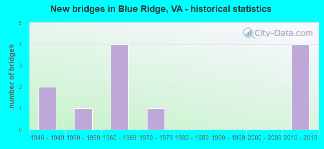
- New bridges - historical statistics
- 21940-1949
- 11950-1959
- 41960-1969
- 11970-1979
- 42010-2019


- Bridge Condition - Deck
- 14.3%Excellent
- 28.6%Very good
- 28.6%Good
- 28.6%Satisfactory

- Bridge Condition - Superstructure
- 11.1%Excellent
- 22.2%Very good
- 33.3%Good
- 33.3%Satisfactory

- Bridge Condition - Substructure
- 22.2%Very good
- 55.6%Good
- 11.1%Satisfactory
- 11.1%Fair

- Bridge Condition - Channel
- 55.6%Very good
- 11.1%Good
- 33.3%Satisfactory

- Bridge Condition - Culverts
- 66.7%Good
- 33.3%Satisfactory
Find on map >> Show street view
Structure Number: 2646, Location: 1.17 Rte 802E;0.08 Bot Co (Lat: 37.385725, Lng: -79.796678), Route carried "on" structure: US 221, Year Built: 1966, Status: Open, Structure Length: 1.68m (5.51ft), Average Daily Traffic: 15,222 (year 2020), Truck Traffic: 11%, Average Future Daily Traffic: 19,724 (year 2040), Design Load: HS 20+Mod, Features Intersected: Conveyor Belt
Minimum Vertical Clearance: 30+ m (98+ ft), Kilometerpoint: 265.565, Lanes on structure: 2, Base Highway Network: Yes, Owner: State Highway Agency, Approaching Roadway Width: 12.2m (40.0ft), Skew: 1 degrees, Material/Design: Steel, Design/Construction: Stringer/Multi-beam, Number Of Spans In Main Unit: 1, Length of Maximum Span: 16.8m (55.1ft), Curb-To-Curb Width: 12.2m (40.0ft), Out-to-Out Width: 12.8m (42.0ft)
Condition: Deck: Satisfactory, Superstructure: Satisfactory, Substructure: Fair, Channel: Good, Operating Rating: 57.2 metric tons, Method Used To Determine Operating Rating: Load and Resistance Factor (LRFR), Inventory Rating: 44.5 metric tons, Method Used To Determine Inventory Rating: Load and Resistance Factor (LRFR), Structural Evaluation: Somewhat better than minimum adequacy, Deck Geometry: Somewhat better than minimum adequacy, Approach Roadway Alignment: Equal to present desirable criteria, Length Of Structure Improvement: 0.76m (2.49ft), Designated Inspection Frequency: Every 24 months, Inspection Date: May 2021, Bridge Improvement Cost: $1,146,000, Roadway Improvement Cost: $401,000, Total Project Cost: $3,840,000 ( Estimate for 2021), Deck Structure Type: Concrete Cast-file-Place, Wearing Surface/Protective System: Wearing Surface: Bituminous
Find on map >> Show street view
Structure Number: 3324, Location: 0.07-Rte607; 0.20-Rte768 (Lat: 37.351256, Lng: -79.813247), Route carried "on" structure: County highway 603, Year Built: 1946, Status: Open, Structure Length: 0.85m (2.79ft), Average Daily Traffic: 388 (year 2016), Average Future Daily Traffic: 515 (year 2040), Design Load: HL 93, Features Intersected: Glade Creek
Minimum Vertical Clearance: 30+ m (98+ ft), Kilometerpoint: 2.776, Lanes on structure: 1, Owner: State Highway Agency, Approaching Roadway Width: 4.9m (16.1ft), Material/Design: Concrete, Design/Construction: Box Beam or Girders - Multiple, Number Of Spans In Main Unit: 1, Length of Maximum Span: 7.3m (24.0ft), Curb or Sidewalk Widths: Left: 0.1m (0.3ft), Right: 0.1m (0.3ft), Curb-To-Curb Width: 4.1m (13.5ft), Out-to-Out Width: 4.2m (13.8ft)
Condition: Deck: Excellent, Superstructure: Excellent, Substructure: Good, Channel: Very good, Operating Rating: 67.1 metric tons, Method Used To Determine Operating Rating: Load and Resistance Factor (LRFR), Inventory Rating: 51.7 metric tons, Method Used To Determine Inventory Rating: Load and Resistance Factor (LRFR), Structural Evaluation: Better than present minimum criteria, Deck Geometry: High priority of replacement, Waterway Adequacy: Equal to present minimum criteria, Approach Roadway Alignment: Equal to present desirable criteria, Length Of Structure Improvement: 0.85m (2.79ft), Designated Inspection Frequency: Every 24 months, Inspection Date: April 2020, Bridge Improvement Cost: $218,000, Roadway Improvement Cost: $33,000, Total Project Cost: $644,000 ( Estimate for 2020), Deck Structure Type: Other, Wearing Surface/Protective System: Wearing Surface: Bituminous
Find on map >> Show street view
Structure Number: 3337, Location: 0.0-Rte640; 0.55-dead end (Lat: 37.450914, Lng: -79.785406), Route carried "on" structure: County highway 606, Year Built: 1961, Year Reconstructed: 1996, Status: Open, Structure Length: 0.82m (2.69ft), Average Daily Traffic: 98 (year 2019), Average Future Daily Traffic: 108 (year 2040), Features Intersected: Back Creek
Minimum Vertical Clearance: 30+ m (98+ ft), Kilometerpoint: 22.172, Lanes on structure: 2, Owner: State Highway Agency, Approaching Roadway Width: 4.0m (13.1ft), Material/Design: Steel, Design/Construction: Stringer/Multi-beam, Number Of Spans In Main Unit: 1, Length of Maximum Span: 7.3m (24.0ft), Curb or Sidewalk Widths: Left: 0.2m (0.7ft), Right: 0.2m (0.7ft), Curb-To-Curb Width: 5.9m (19.4ft), Out-to-Out Width: 6.4m (21.0ft)
Condition: Deck: Satisfactory, Superstructure: Good, Substructure: Satisfactory, Channel: Satisfactory, Operating Rating: 59.0 metric tons, Method Used To Determine Operating Rating: Load and Resistance Factor (LRFR), Inventory Rating: 45.4 metric tons, Method Used To Determine Inventory Rating: Load and Resistance Factor (LRFR), Structural Evaluation: Equal to present minimum criteria, Deck Geometry: Meets minimum limits, Waterway Adequacy: Equal to present minimum criteria, Approach Roadway Alignment: Equal to present desirable criteria, Length Of Structure Improvement: 0.82m (2.69ft), Designated Inspection Frequency: Every 24 months, Inspection Date: June 2020, Bridge Improvement Cost: $405,000, Roadway Improvement Cost: $101,000, Total Project Cost: $1,295,000 ( Estimate for 2020), Deck Structure Type: Wood or Timber, Wearing Surface/Protective System: Wearing Surface: Bituminous
Find on map >> Show street view
Structure Number: 334, Location: 0.15-Rt603; 1.85-Bedford (Lat: 37.352569, Lng: -79.811461), Route carried "on" structure: County highway 607, Year Built: 1973, Status: Open, Structure Length: 0.88m (2.89ft), Average Daily Traffic: 1,214 (year 2016), Average Future Daily Traffic: 1,797 (year 2040), Design Load: H 20, Features Intersected: Glade Creek
Minimum Vertical Clearance: 30+ m (98+ ft), Kilometerpoint: 1.874, Lanes on structure: 2, Owner: State Highway Agency, Approaching Roadway Width: 6.1m (20.0ft), Skew: 1 degrees, Material/Design: Steel, Design/Construction: Culvert, Number Of Spans In Main Unit: 2, Length of Maximum Span: 3.4m (11.2ft)
Condition: Channel: Satisfactory, Culverts: Satisfactory, Operating Rating: 89.8 metric tons, Method Used To Determine Operating Rating: Field evaluation and documented engineering judgment, Inventory Rating: 89.8 metric tons, Method Used To Determine Inventory Rating: Field evaluation and documented engineering judgment, Structural Evaluation: Equal to present minimum criteria, Waterway Adequacy: Better than present minimum criteria, Approach Roadway Alignment: Equal to present desirable criteria, Length Of Structure Improvement: 0.88m (2.89ft), Designated Inspection Frequency: Every 24 months, Inspection Date: November 2020, Bridge Improvement Cost: $416,000, Roadway Improvement Cost: $104,000, Total Project Cost: $1,330,000 ( Estimate for 2020)
Find on map >> Show street view
Structure Number: 3435, Location: 0.01-Rte606; 1.05-Rte763 (Lat: 37.451717, Lng: -79.783700), Route carried "on" structure: County highway 640, Year Built: 1958, Status: Open, Structure Length: 2.01m (6.59ft), Average Daily Traffic: 238 (year 2016), Average Future Daily Traffic: 267 (year 2040), Design Load: HS 15, Features Intersected: Back Creek
Minimum Vertical Clearance: 30+ m (98+ ft), Kilometerpoint: 13.210, Lanes on structure: 2, Owner: State Highway Agency, Approaching Roadway Width: 5.5m (18.0ft), Skew: 4 degrees, Material/Design: Steel, Design/Construction: Stringer/Multi-beam, Number Of Spans In Main Unit: 1, Length of Maximum Span: 19.8m (65.0ft), Curb or Sidewalk Widths: Left: 0.7m (2.3ft), Right: 0.7m (2.3ft), Curb-To-Curb Width: 7.3m (24.0ft), Out-to-Out Width: 8.8m (28.9ft)
Condition: Deck: Good, Superstructure: Good, Substructure: Good, Channel: Very good, Operating Rating: 54.4 metric tons, Method Used To Determine Operating Rating: Load and Resistance Factor (LRFR), Inventory Rating: 41.7 metric tons, Method Used To Determine Inventory Rating: Load and Resistance Factor (LRFR), Structural Evaluation: Better than present minimum criteria, Deck Geometry: Somewhat better than minimum adequacy, Waterway Adequacy: Better than present minimum criteria, Approach Roadway Alignment: Equal to present minimum criteria, Length Of Structure Improvement: 2.01m (6.59ft), Designated Inspection Frequency: Every 24 months, Inspection Date: September 2021, Bridge Improvement Cost: $659,000, Roadway Improvement Cost: $231,000, Total Project Cost: $2,143,000 ( Estimate for 2019), Deck Structure Type: Concrete Cast-file-Place, Wearing Surface/Protective System: Wearing Surface: Epoxy Overlay
Find on map >> Show street view
Structure Number: 3515, Location: 0.10-Rte607; 0.00-Rte607 (Lat: 37.354839, Lng: -79.818431), Route carried "on" structure: County highway 738, Year Built: 2011, Status: Open, Structure Length: 2.13m (6.99ft), Average Daily Traffic: 1,189 (year 2020), Truck Traffic: 3%, Average Future Daily Traffic: 1,318 (year 2040), Design Load: HS 20+Mod, Features Intersected: Branch of Glade Creek
Minimum Vertical Clearance: 30+ m (98+ ft), Kilometerpoint: 4.666, Lanes on structure: 2, Owner: State Highway Agency, Approaching Roadway Width: 6.6m (21.7ft), Material/Design: Prestressed concrete, Design/Construction: Box Beam or Girders - Multiple, Number Of Spans In Main Unit: 2, Length of Maximum Span: 10.7m (35.1ft), Curb or Sidewalk Widths: Left: 0.4m (1.3ft), Right: 0.4m (1.3ft), Curb-To-Curb Width: 7.2m (23.6ft), Out-to-Out Width: 12.8m (42.0ft)
Condition: Deck: Very good, Superstructure: Very good, Substructure: Very good, Channel: Very good, Operating Rating: 61.7 metric tons, Method Used To Determine Operating Rating: Load and Resistance Factor (LRFR), Inventory Rating: 48.1 metric tons, Method Used To Determine Inventory Rating: Load and Resistance Factor (LRFR), Structural Evaluation: Equal to present desirable criteria, Deck Geometry: High priority of corrective action, Waterway Adequacy: Equal to present minimum criteria, Approach Roadway Alignment: Equal to present minimum criteria, Length Of Structure Improvement: 2.19m (7.19ft), Designated Inspection Frequency: Every 24 months, Inspection Date: October 2021, Bridge Improvement Cost: $1,156,000, Roadway Improvement Cost: $173,000, Total Project Cost: $3,411,000 ( Estimate for 2021), Wearing Surface/Protective System: Wearing Surface: Bituminous
Find on map >> Show street view
Structure Number: 3542, Location: 0.01-Rte460; 0.09-Rte1505 (Lat: 37.366694, Lng: -79.817169), Route carried "on" structure: Alternate County highway 1506, Year Built: 1965, Status: Open, Structure Length: 0.78m (2.56ft), Average Daily Traffic: 96 (year 2019), Average Future Daily Traffic: 127 (year 2040), Design Load: HS 20, Features Intersected: Branch Glade Creek
Minimum Vertical Clearance: 30+ m (98+ ft), Kilometerpoint: 0.008, Lanes on structure: 2, Owner: State Highway Agency, Approaching Roadway Width: 4.3m (14.1ft), Material/Design: Concrete, Design/Construction: Culvert, Number Of Spans In Main Unit: 3, Length of Maximum Span: 2.4m (7.9ft)
Condition: Channel: Satisfactory, Culverts: Good, Operating Rating: 54.4 metric tons, Method Used To Determine Operating Rating: Field evaluation and documented engineering judgment, Inventory Rating: 32.7 metric tons, Method Used To Determine Inventory Rating: Field evaluation and documented engineering judgment, Structural Evaluation: Better than present minimum criteria, Waterway Adequacy: Better than present minimum criteria, Approach Roadway Alignment: Equal to present desirable criteria, Length Of Structure Improvement: 0.78m (2.56ft), Designated Inspection Frequency: Every 24 months, Inspection Date: May 2021, Bridge Improvement Cost: $387,000, Roadway Improvement Cost: $97,000, Total Project Cost: $1,259,000 ( Estimate for 2021)
Find on map >> Show street view
Structure Number: 25967, Location: 1.55-Rte 606;0.89 Rte 640 (Lat: 37.460639, Lng: -79.818778), Route carried "on" structure: US 11, Year Built: 2013, Status: Open, Structure Length: 1.38m (4.53ft), Average Daily Traffic: 2,807 (year 2020), Truck Traffic: 5%, Average Future Daily Traffic: 3,062 (year 2040), Design Load: HS 20+Mod, Features Intersected: Firestone Creek
Minimum Vertical Clearance: 30.18m (99.02ft), Kilometerpoint: 0.000, Lanes on structure: 4, Owner: State Highway Agency, Approaching Roadway Width: 14.3m (46.9ft), Skew: 1 degrees, Material/Design: Prestressed concrete, Design/Construction: Box Beam or Girders - Multiple, Number Of Spans In Main Unit: 1, Length of Maximum Span: 12.3m (40.4ft), Curb or Sidewalk Widths: Left: 0.4m (1.3ft), Right: 0.4m (1.3ft), Curb-To-Curb Width: 20.0m (65.6ft), Out-to-Out Width: 20.8m (68.2ft)
Condition: Deck: Good, Superstructure: Good, Substructure: Good, Channel: Very good, Operating Rating: 89.8 metric tons, Method Used To Determine Operating Rating: Load and Resistance Factor (LRFR), Inventory Rating: 88.9 metric tons, Method Used To Determine Inventory Rating: Load and Resistance Factor (LRFR), Structural Evaluation: Better than present minimum criteria, Deck Geometry: Better than present minimum criteria, Waterway Adequacy: Superior to present desirable criteria, Approach Roadway Alignment: Superior to present desirable criteria, Length Of Structure Improvement: 1.38m (4.53ft), Designated Inspection Frequency: Every 24 months, Inspection Date: July 2021, Bridge Improvement Cost: $1,278,000, Roadway Improvement Cost: $383,000, Total Project Cost: $4,090,000 ( Estimate for 2019), Deck Structure Type: Concrete Cast-file-Place, Wearing Surface/Protective System: Deck Protection: Epoxy Coated Reinforcing
Find on map >> Show street view
Structure Number: 30505, Location: .02-Rte1536; .02-Rte1532_ (Lat: 37.372225, Lng: -79.816944), Route carried "on" structure: County highway 1537, Year Built: 2017, Status: Open, Structure Length: 0.65m (2.13ft), Average Daily Traffic: 80 (year 2019), Average Future Daily Traffic: 88 (year 2040), Features Intersected: Branch of Glade Creek, Facility Carried by Structure: Oaklawn Drive
Minimum Vertical Clearance: 30+ m (98+ ft), Kilometerpoint: 0.145, Lanes on structure: 2, Owner: State Highway Agency, Approaching Roadway Width: 6.1m (20.0ft), Skew: 3 degrees, Material/Design: Concrete, Design/Construction: Culvert, Number Of Spans In Main Unit: 2, Length of Maximum Span: 3.0m (9.8ft)
Condition: Channel: Very good, Culverts: Good, Operating Rating: 89.8 metric tons, Method Used To Determine Operating Rating: Load Factor (LF), Inventory Rating: 61.7 metric tons, Method Used To Determine Inventory Rating: Load Factor (LF), Structural Evaluation: Better than present minimum criteria, Waterway Adequacy: Superior to present desirable criteria, Approach Roadway Alignment: Equal to present desirable criteria, Length Of Structure Improvement: 0.65m (2.13ft), Designated Inspection Frequency: Every 24 months, Inspection Date: October 2021, Bridge Improvement Cost: $262,000, Roadway Improvement Cost: $66,000, Total Project Cost: $852,000 ( Estimate for 2021)
Find on map >> Show street view
Structure Number: 30873, Location: 1.2M Spotsy-6.9M Rte630 (Lat: 38.340456, Lng: -77.492478), Route carried "on" structure: Interstate 95, Year Built: 2019, Status: Open, Structure Length: 4.42m (14.50ft), Average Daily Traffic: 70,840 (year 2014), Truck Traffic: 13%, Average Future Daily Traffic: 147,380 (year 2024), Design Load: HL 93, Features Intersected: ROUTE 17
Minimum Vertical Clearance: 30+ m (98+ ft), Kilometerpoint: 0.000, Lanes on structure: 3, Lanes under structure: 6, Owner: State Highway Agency, Approaching Roadway Width: 11.0m (36.1ft), Material/Design: Prestressed concrete, Design/Construction: Girder and Floorbeam System, Number Of Spans In Main Unit: 2, Length of Maximum Span: 22.7m (74.5ft), Curb-To-Curb Width: 11.0m (36.1ft), Out-to-Out Width: 19.3m (63.3ft)
Condition: Deck: Very good, Superstructure: Very good, Substructure: Very good, Operating Rating: 92.5 metric tons, Method Used To Determine Operating Rating: Load and Resistance Factor (LRFR), Inventory Rating: 51.0 metric tons, Method Used To Determine Inventory Rating: Load and Resistance Factor (LRFR), Structural Evaluation: Equal to present desirable criteria, Deck Geometry: High priority of replacement, Underclear: High priority of corrective action, Approach Roadway Alignment: Equal to present desirable criteria, Designated Inspection Frequency: Every 24 months, Inspection Date: October 2021, Deck Structure Type: Concrete Cast-file-Place, Wearing Surface/Protective System: Deck Protection: Other
Find on map >> Show street view
Structure Number: 5140020P, Location: 1.4 MILES TO U.S. ROUTE 4 (Lat: 37.376500, Lng: -79.838611), Route carried "on" structure: Federal lands road 1, Year Built: 1946, Status: Posted for load-capacity, Structure Length: 0.76m (2.49ft), Average Daily Traffic: 474 (year 2012), Average Future Daily Traffic: 521 (year 2032), Features Intersected: VA ROUTE 652, Facility Carried by Structure: BLUE RIDGE PARKWAY
Minimum Vertical Clearance: 30+ m (98+ ft), Kilometerpoint: 167.900, Lanes on structure: 2, Lanes under structure: 2, Owner: National Park Service, Approaching Roadway Width: 9.8m (32.2ft), Material/Design: Concrete, Design/Construction: Frame, Number Of Spans In Main Unit: 1, Length of Maximum Span: 7.6m (24.9ft), Curb-To-Curb Width: 9.8m (32.2ft), Out-to-Out Width: 11.0m (36.1ft)
Condition: Superstructure: Satisfactory, Substructure: Good, Operating Rating: 39.0 metric tons, Method Used To Determine Operating Rating: Field evaluation and documented engineering judgment, Inventory Rating: 23.6 metric tons, Method Used To Determine Inventory Rating: Field evaluation and documented engineering judgment, Structural Evaluation: Equal to present minimum criteria, Deck Geometry: Equal to present minimum criteria, Approach Roadway Alignment: Equal to present minimum criteria, Designated Inspection Frequency: Every 48 months, Inspection Date: June 2020, Bridge Improvement Cost: $45,000, Roadway Improvement Cost: $5,000, Total Project Cost: $68,000 ( Estimate for 2016)
Find on map >> Show street view
Structure Number: 5140022P, Location: 1.0 MILES TO VA ROUTE 657 (Lat: 37.355833, Lng: -79.835583), Route carried "on" structure: Federal lands road 1, Year Built: 1965, Status: Posted for load-capacity, Structure Length: 1.26m (4.13ft), Average Daily Traffic: 474 (year 2012), Average Future Daily Traffic: 521 (year 2032), Design Load: H 20, Features Intersected: BLUE RIDGE PARKWAY, Facility Carried by Structure: U.S. ROUTE 460
Minimum Vertical Clearance: 30+ m (98+ ft), Kilometerpoint: 170.260, Lanes on structure: 4, Lanes under structure: 2, Owner: National Park Service, Approaching Roadway Width: 12.1m (39.7ft), Skew: 15 degrees, Material/Design: Concrete, Design/Construction: Arch - Deck, Number Of Spans In Main Unit: 1, Length of Maximum Span: 12.6m (41.3ft), Curb-To-Curb Width: 25.6m (84.0ft), Out-to-Out Width: 29.2m (95.8ft)
Condition: Superstructure: Satisfactory, Substructure: Good, Structural Evaluation: Equal to present minimum criteria, Deck Geometry: Superior to present desirable criteria, Approach Roadway Alignment: Equal to present desirable criteria, Designated Inspection Frequency: Every 24 months, Inspection Date: June 2020, Bridge Improvement Cost: $157,000, Roadway Improvement Cost: $16,000, Total Project Cost: $236,000 ( Estimate for 2018)