Bridge Statistics for Bluefield, West Virginia (WV)
Condition, Traffic, Stress, Structural Evaluation, Project Costs
- National Bridge Inventory (NBI) Statistics
- 42Number of bridges
- 761ft / 232mTotal length
- $48,950,000Total costs
- 209,497Total average daily traffic
- 31,623Total average daily truck traffic
- National Bridge Inventory (NBI) Registered Bridges for Bluefield
- No street view available for this location
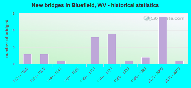
- New bridges - historical statistics
- 31920-1929
- 31930-1939
- 11940-1949
- 81960-1969
- 91970-1979
- 11980-1989
- 21990-1999
- 142000-2009
- 12010-2019
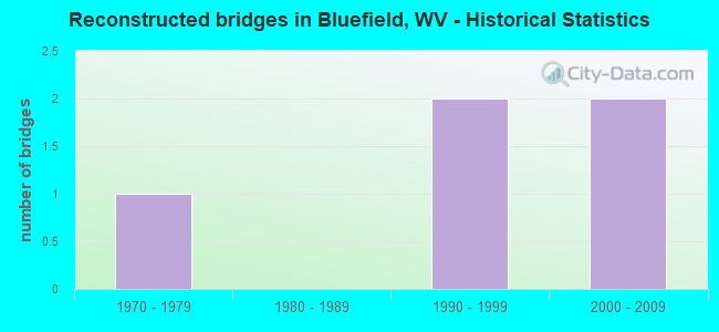
- Reconstructed bridges - Historical Statistics
- 11970-1979
- 01980-1989
- 21990-1999
- 22000-2009
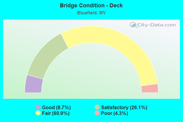
- Bridge Condition - Deck
- 8.7%Good
- 26.1%Satisfactory
- 60.9%Fair
- 4.3%Poor
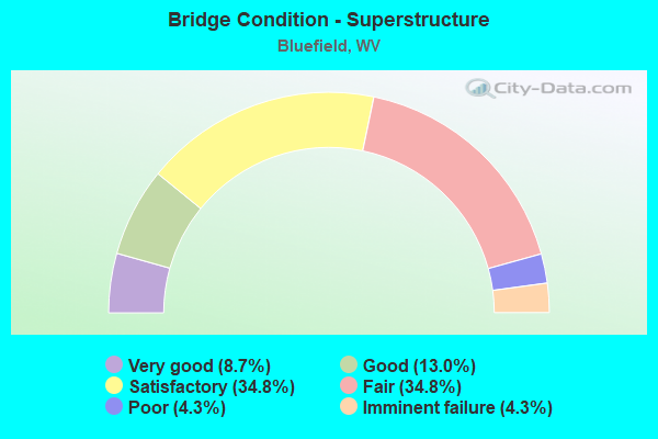
- Bridge Condition - Superstructure
- 8.7%Very good
- 13.0%Good
- 34.8%Satisfactory
- 34.8%Fair
- 4.3%Poor
- 4.3%Imminent failure
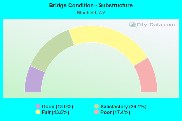
- Bridge Condition - Substructure
- 13.0%Good
- 26.1%Satisfactory
- 43.5%Fair
- 17.4%Poor
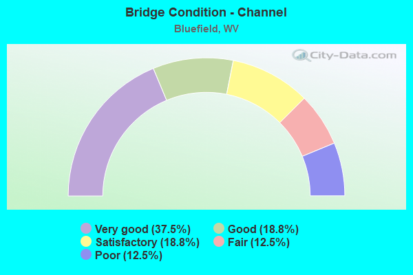
- Bridge Condition - Channel
- 37.5%Very good
- 18.8%Good
- 18.8%Satisfactory
- 12.5%Fair
- 12.5%Poor
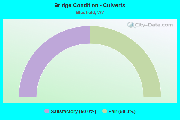
- Bridge Condition - Culverts
- 50.0%Satisfactory
- 50.0%Fair
Find on map >> Show street view
Structure Number: 28A073, Location: 0.01 MI. E. OF CR. 19/33 (Lat: 37.309550, Lng: -81.140581), Route carried "on" structure: County highway 1919, Year Built: 1937, Year Reconstructed: 1983, Status: Open, Structure Length: 0.85m (2.79ft), Average Daily Traffic: 50 (year 2018), Truck Traffic: 2%, Average Future Daily Traffic: 61 (year 2038), Features Intersected: SOUTH FORK, Facility Carried by Structure: CR. 19/19
Minimum Vertical Clearance: 30+ m (98+ ft), Kilometerpoint: 0.113, Lanes on structure: 1, Owner: State Highway Agency, Approaching Roadway Width: 3.7m (12.1ft), Material/Design: Steel, Design/Construction: Stringer/Multi-beam, Number Of Spans In Main Unit: 1, Length of Maximum Span: 7.9m (25.9ft), Curb or Sidewalk Widths: Left: 0.2m (0.7ft), Right: 0.2m (0.7ft), Curb-To-Curb Width: 4.0m (13.1ft), Out-to-Out Width: 4.3m (14.1ft)
Condition: Deck: Fair, Superstructure: Fair, Substructure: Fair, Channel: Satisfactory, Operating Rating: 88.9 metric tons, Method Used To Determine Operating Rating: Load Factor (LF), Inventory Rating: 61.7 metric tons, Method Used To Determine Inventory Rating: Load Factor (LF), Structural Evaluation: Somewhat better than minimum adequacy, Deck Geometry: Somewhat better than minimum adequacy, Waterway Adequacy: Better than present minimum criteria, Approach Roadway Alignment: Meets minimum limits, Designated Inspection Frequency: Every 24 months, Inspection Date: Febuary 2020, Deck Structure Type: Wood or Timber, Wearing Surface/Protective System: Wearing Surface: Bituminous
Find on map >> Show street view
Structure Number: 28A086, Location: 0.01 MI. N. OF US. 19 (Lat: 37.278481, Lng: -81.193211), Route carried "on" structure: County highway 2500, Year Built: 1987, Status: Open, Structure Length: 6.96m (22.83ft), Average Daily Traffic: 4,000 (year 2018), Truck Traffic: 2%, Average Future Daily Traffic: 4,840 (year 2038), Design Load: HS 20, Features Intersected: NORFOLK & SOUTHERN RR, Facility Carried by Structure: CR. 25
Minimum Vertical Clearance: 30+ m (98+ ft), Kilometerpoint: 2.768, Lanes on structure: 2, Owner: State Highway Agency, Approaching Roadway Width: 7.3m (24.0ft), Material/Design: Steel continuous, Design/Construction: Stringer/Multi-beam, Number Of Spans In Main Unit: 1, Number Of Approach Spans: 3, Length of Maximum Span: 17.2m (56.4ft), Curb-To-Curb Width: 9.1m (29.9ft), Out-to-Out Width: 10.2m (33.5ft)
Condition: Deck: Fair, Superstructure: Fair, Substructure: Poor, Operating Rating: 77.1 metric tons, Method Used To Determine Operating Rating: Load Factor (LF), Inventory Rating: 46.3 metric tons, Method Used To Determine Inventory Rating: Load Factor (LF), Structural Evaluation: Meets minimum limits, Deck Geometry: Meets minimum limits, Underclear: High priority of replacement, Approach Roadway Alignment: Meets minimum limits, Length Of Structure Improvement: 6.95m (22.80ft), Designated Inspection Frequency: Every 24 months, Inspection Date: July 2020, Bridge Improvement Cost: $9,000,000, Roadway Improvement Cost: $1,000,000, Total Project Cost: $10,000,000 ( Estimate for 2020), Deck Structure Type: Concrete Cast-file-Place, Wearing Surface/Protective System: Wearing Surface: Monolithic Concrete, Deck Protection: Epoxy Coated Reinforcing
Find on map >> Show street view
Structure Number: 28A098, Location: 0.36 MI. W. OF WV 112 (Lat: 37.310081, Lng: -81.057269), Route carried "on" structure: County highway 3805, Year Built: 1964, Status: Posted for load, Structure Length: 1.28m (4.20ft), Average Daily Traffic: 50 (year 2018), Truck Traffic: 2%, Average Future Daily Traffic: 61 (year 2038), Design Load: HS 20, Features Intersected: EAST RIVER, Facility Carried by Structure: CR 38/5
Minimum Vertical Clearance: 30+ m (98+ ft), Kilometerpoint: 7.870, Lanes on structure: 1, Owner: State Highway Agency, Approaching Roadway Width: 7.3m (24.0ft), Skew: 5 degrees, Material/Design: Steel, Design/Construction: Girder and Floorbeam System, Number Of Spans In Main Unit: 1, Length of Maximum Span: 11.0m (36.1ft), Curb-To-Curb Width: 3.9m (12.8ft), Out-to-Out Width: 4.3m (14.1ft)
Condition: Deck: Fair, Superstructure: Poor, Substructure: Poor, Channel: Fair, Operating Rating: 34.5 metric tons, Method Used To Determine Operating Rating: Load Factor (LF), Inventory Rating: 20.9 metric tons, Method Used To Determine Inventory Rating: Load Factor (LF), Structural Evaluation: Meets minimum limits, Deck Geometry: Meets minimum limits, Waterway Adequacy: Equal to present minimum criteria, Approach Roadway Alignment: Somewhat better than minimum adequacy, Bridge Posting: Required (Relationship of Operating Rating to Maximum Legal Load: 0.1 - 9.9% below), Length Of Structure Improvement: 1.28m (4.20ft), Designated Inspection Frequency: Every 24 months, Critical Feature Inspection Frequency: Every 24 months, Inspection Date: October 2020, Critical Feature Inspection Date: October 2020, Bridge Improvement Cost: $400,000, Roadway Improvement Cost: $50,000, Total Project Cost: $450,000 ( Estimate for 2020), Deck Structure Type: Wood or Timber, Wearing Surface/Protective System: Wearing Surface: Bituminous
Find on map >> Show street view
Structure Number: 28A099, Location: 0.03 MI W OF WV 112 (Lat: 37.313900, Lng: -81.054469), Route carried "on" structure: County highway 3805, Year Built: 1992, Status: Open, Structure Length: 1.02m (3.35ft), Average Daily Traffic: 50 (year 2018), Truck Traffic: 2%, Average Future Daily Traffic: 61 (year 2038), Design Load: HS 25 or greater, Features Intersected: TWELVEMILE CREEK, Facility Carried by Structure: CR 38/5
Minimum Vertical Clearance: 30+ m (98+ ft), Kilometerpoint: 8.401, Lanes on structure: 2, Owner: State Highway Agency, Approaching Roadway Width: 7.3m (24.0ft), Material/Design: Prestressed concrete, Design/Construction: Box Beam or Girders - Multiple, Number Of Spans In Main Unit: 1, Length of Maximum Span: 9.1m (29.9ft), Curb-To-Curb Width: 9.1m (29.9ft), Out-to-Out Width: 9.2m (30.2ft)
Condition: Deck: Satisfactory, Superstructure: Good, Substructure: Good, Channel: Satisfactory, Operating Rating: 88.9 metric tons, Method Used To Determine Operating Rating: Load Factor (LF), Inventory Rating: 86.2 metric tons, Method Used To Determine Inventory Rating: Load Factor (LF), Structural Evaluation: Better than present minimum criteria, Deck Geometry: Better than present minimum criteria, Waterway Adequacy: Equal to present desirable criteria, Approach Roadway Alignment: Meets minimum limits, Designated Inspection Frequency: Every 48 months, Inspection Date: November 2019, Deck Structure Type: Other, Wearing Surface/Protective System: Wearing Surface: Integral Concrete, Deck Protection: Epoxy Coated Reinforcing
Find on map >> Show street view
Structure Number: 28A113, Location: 2.12 MI. S. WV.112 (Lat: 37.302000, Lng: -81.093950), Route carried "on" structure: Interstate 7700, Year Built: 1972, Year Reconstructed: 1999, Status: Open, Structure Length: 14.93m (48.98ft), Average Daily Traffic: 13,300 (year 2018), Truck Traffic: 34%, Average Future Daily Traffic: 18,886 (year 2038), Design Load: HS 20, Features Intersected: East River NSRR CO 38/5, Facility Carried by Structure: I-77 SB
Minimum Vertical Clearance: 30+ m (98+ ft), Kilometerpoint: 4.748, Lanes on structure: 2, Lanes under structure: 1, Base Highway Network: Yes, Owner: State Highway Agency, Approaching Roadway Width: 11.0m (36.1ft), Skew: 2 degrees, Material/Design: Steel continuous, Design/Construction: Stringer/Multi-beam, Number Of Spans In Main Unit: 2, Number Of Approach Spans: 2, Length of Maximum Span: 41.1m (134.8ft), Curb-To-Curb Width: 10.0m (32.8ft), Out-to-Out Width: 11.0m (36.1ft)
Condition: Deck: Fair, Superstructure: Fair, Substructure: Fair, Channel: Good, Operating Rating: 86.2 metric tons, Method Used To Determine Operating Rating: Load Factor (LF), Inventory Rating: 51.7 metric tons, Method Used To Determine Inventory Rating: Load Factor (LF), Structural Evaluation: Somewhat better than minimum adequacy, Deck Geometry: Meets minimum limits, Underclear: Meets minimum limits, Waterway Adequacy: Superior to present desirable criteria, Approach Roadway Alignment: Better than present minimum criteria, Designated Inspection Frequency: Every 24 months, Inspection Date: May 2020, Deck Structure Type: Concrete Cast-file-Place, Wearing Surface/Protective System: Deck Protection: Epoxy Coated Reinforcing
Find on map >> Show street view
Structure Number: 28A114, Location: 1.64 MI S OF CR 27 (Lat: 37.313219, Lng: -81.060011), Route carried "on" structure: Interstate 7700, Year Built: 1967, Year Reconstructed: 2008, Status: Open, Structure Length: 5.81m (19.06ft), Average Daily Traffic: 10,650 (year 2019), Truck Traffic: 33%, Average Future Daily Traffic: 12,993 (year 2039), Features Intersected: WV 112, Facility Carried by Structure: I-77 NB
Minimum Vertical Clearance: 30+ m (98+ ft), Kilometerpoint: 8.159, Lanes on structure: 2, Lanes under structure: 2, Base Highway Network: Yes, Owner: State Highway Agency, Approaching Roadway Width: 11.0m (36.1ft), Skew: 3 degrees, Material/Design: Steel continuous, Design/Construction: Stringer/Multi-beam, Number Of Spans In Main Unit: 1, Number Of Approach Spans: 2, Length of Maximum Span: 22.5m (73.8ft), Curb-To-Curb Width: 11.8m (38.7ft), Out-to-Out Width: 12.6m (41.3ft)
Condition: Deck: Fair, Superstructure: Satisfactory, Substructure: Satisfactory, Operating Rating: 59.9 metric tons, Method Used To Determine Operating Rating: Load and Resistance Factor (LRFR), Inventory Rating: 46.3 metric tons, Method Used To Determine Inventory Rating: Load and Resistance Factor (LRFR), Structural Evaluation: Equal to present minimum criteria, Deck Geometry: Equal to present minimum criteria, Underclear: Somewhat better than minimum adequacy, Approach Roadway Alignment: Equal to present minimum criteria, Designated Inspection Frequency: Every 24 months, Inspection Date: June 2021, Deck Structure Type: Concrete Cast-file-Place, Wearing Surface/Protective System: Wearing Surface: Monolithic Concrete, Deck Protection: Epoxy Coated Reinforcing
Find on map >> Show street view
Structure Number: 28A146, Location: 0.34 MI S OF CR 25 (Lat: 37.283561, Lng: -81.167961), Route carried "on" structure: US 1900, Year Built: 1974, Status: Open, Structure Length: 19.76m (64.83ft), Average Daily Traffic: 7,950 (year 2018), Truck Traffic: 7%, Average Future Daily Traffic: 9,620 (year 2038), Design Load: HS 20, Features Intersected: WV 112, NSRR, and East R, Facility Carried by Structure: US 19
Minimum Vertical Clearance: 30+ m (98+ ft), Kilometerpoint: 8.690, Lanes on structure: 3, Lanes under structure: 2, Base Highway Network: Yes, Owner: State Highway Agency, Approaching Roadway Width: 11.0m (36.1ft), Material/Design: Steel continuous, Design/Construction: Stringer/Multi-beam, Number Of Spans In Main Unit: 3, Number Of Approach Spans: 2, Length of Maximum Span: 45.7m (149.9ft), Curb-To-Curb Width: 13.6m (44.6ft), Out-to-Out Width: 14.9m (48.9ft)
Condition: Deck: Fair, Superstructure: Fair, Substructure: Poor, Channel: Good, Operating Rating: 77.1 metric tons, Method Used To Determine Operating Rating: Load Factor (LF), Inventory Rating: 46.3 metric tons, Method Used To Determine Inventory Rating: Load Factor (LF), Structural Evaluation: Meets minimum limits, Deck Geometry: Meets minimum limits, Underclear: Equal to present desirable criteria, Waterway Adequacy: Superior to present desirable criteria, Approach Roadway Alignment: Better than present minimum criteria, Length Of Structure Improvement: 19.48m (63.91ft), Designated Inspection Frequency: Every 24 months, Inspection Date: August 2020, Bridge Improvement Cost: $12,000,000, Roadway Improvement Cost: $2,000,000, Total Project Cost: $14,000,000 ( Estimate for 2021), Deck Structure Type: Concrete Cast-file-Place, Wearing Surface/Protective System: Wearing Surface: Latex Concrete
Find on map >> Show street view
Structure Number: 28A155, Location: 0.06 MI. N. OF US 460 (Lat: 37.283569, Lng: -81.167750), Route carried "on" structure: US 1900, Year Built: 1974, Status: Open, Structure Length: 20.39m (66.90ft), Average Daily Traffic: 7,950 (year 2018), Truck Traffic: 7%, Average Future Daily Traffic: 9,620 (year 2038), Design Load: HS 20, Features Intersected: US 19, Facility Carried by Structure: US 19 (NB)
Minimum Vertical Clearance: 30+ m (98+ ft), Kilometerpoint: 8.690, Lanes on structure: 2, Lanes under structure: 2, Base Highway Network: Yes, Owner: State Highway Agency, Approaching Roadway Width: 11.0m (36.1ft), Skew: 9 degrees, Material/Design: Steel continuous, Design/Construction: Stringer/Multi-beam, Number Of Spans In Main Unit: 3, Number Of Approach Spans: 2, Length of Maximum Span: 45.7m (149.9ft), Curb-To-Curb Width: 12.3m (40.4ft), Out-to-Out Width: 13.6m (44.6ft)
Condition: Deck: Fair, Superstructure: Fair, Substructure: Poor, Channel: Good, Operating Rating: 79.8 metric tons, Method Used To Determine Operating Rating: Load Factor (LF), Inventory Rating: 47.2 metric tons, Method Used To Determine Inventory Rating: Load Factor (LF), Structural Evaluation: Meets minimum limits, Deck Geometry: Better than present minimum criteria, Underclear: Equal to present minimum criteria, Waterway Adequacy: Superior to present desirable criteria, Approach Roadway Alignment: Equal to present desirable criteria, Length Of Structure Improvement: 20.11m (65.98ft), Designated Inspection Frequency: Every 24 months, Inspection Date: October 2020, Bridge Improvement Cost: $9,000,000, Roadway Improvement Cost: $1,000,000, Total Project Cost: $10,000,000 ( Estimate for 2018), Deck Structure Type: Concrete Cast-file-Place, Wearing Surface/Protective System: Wearing Surface: Latex Concrete
Find on map >> Show street view
Structure Number: 28A159, Location: 0.15 MI. W. OF CR.219/1 (Lat: 37.284319, Lng: -81.125800), Route carried "on" structure: US 5200, Year Built: 1969, Status: Open, Structure Length: 6.58m (21.59ft), Average Daily Traffic: 8,300 (year 2019), Truck Traffic: 9%, Average Future Daily Traffic: 8,715 (year 2039), Design Load: HS 20, Features Intersected: I-77, Facility Carried by Structure: US. 52
Minimum Vertical Clearance: 30+ m (98+ ft), Kilometerpoint: 30.046, Lanes on structure: 3, Lanes under structure: 6, Base Highway Network: Yes, Owner: State Highway Agency, Approaching Roadway Width: 9.8m (32.2ft), Skew: 21 degrees, Material/Design: Steel continuous, Design/Construction: Stringer/Multi-beam, Number Of Spans In Main Unit: 2, Length of Maximum Span: 32.3m (106.0ft), Curb-To-Curb Width: 18.4m (60.4ft), Out-to-Out Width: 19.8m (65.0ft)
Condition: Deck: Fair, Superstructure: Fair, Substructure: Fair, Operating Rating: 70.7 metric tons, Method Used To Determine Operating Rating: Load Factor (LF), Inventory Rating: 42.6 metric tons, Method Used To Determine Inventory Rating: Load Factor (LF), Structural Evaluation: Somewhat better than minimum adequacy, Deck Geometry: Superior to present desirable criteria, Underclear: Somewhat better than minimum adequacy, Approach Roadway Alignment: Equal to present desirable criteria, Designated Inspection Frequency: Every 24 months, Inspection Date: July 2021, Deck Structure Type: Concrete Cast-file-Place, Wearing Surface/Protective System: Wearing Surface: Bituminous
Find on map >> Show street view
Structure Number: 28A162, Location: 0.06 MI N OF WV 112 RAMP (Lat: 37.313189, Lng: -81.060331), Route carried "on" structure: Interstate 7700, Year Built: 1967, Year Reconstructed: 2008, Status: Open, Structure Length: 6.04m (19.82ft), Average Daily Traffic: 10,650 (year 2019), Truck Traffic: 33%, Average Future Daily Traffic: 12,993 (year 2039), Design Load: HL 93, Features Intersected: WV 112, Facility Carried by Structure: I-77 SB
Minimum Vertical Clearance: 30+ m (98+ ft), Kilometerpoint: 8.159, Lanes on structure: 2, Lanes under structure: 2, Base Highway Network: Yes, Owner: State Highway Agency, Approaching Roadway Width: 11.0m (36.1ft), Skew: 4 degrees, Material/Design: Steel continuous, Design/Construction: Stringer/Multi-beam, Number Of Spans In Main Unit: 1, Number Of Approach Spans: 2, Length of Maximum Span: 26.7m (87.6ft), Curb-To-Curb Width: 11.8m (38.7ft), Out-to-Out Width: 12.5m (41.0ft)
Condition: Deck: Satisfactory, Superstructure: Satisfactory, Substructure: Satisfactory, Operating Rating: 47.2 metric tons, Method Used To Determine Operating Rating: Load and Resistance Factor (LRFR), Inventory Rating: 36.3 metric tons, Method Used To Determine Inventory Rating: Load and Resistance Factor (LRFR), Structural Evaluation: Equal to present minimum criteria, Deck Geometry: Equal to present minimum criteria, Underclear: Meets minimum limits, Approach Roadway Alignment: Equal to present desirable criteria, Designated Inspection Frequency: Every 24 months, Inspection Date: June 2021, Deck Structure Type: Concrete Cast-file-Place, Wearing Surface/Protective System: Wearing Surface: Monolithic Concrete, Deck Protection: Epoxy Coated Reinforcing
Find on map >> Show street view
Structure Number: 28A166, Location: 0.13 MI W OF CR 38/5 (Lat: 37.313500, Lng: -81.056411), Route carried "on" structure: State highway 11200, Year Built: 1968, Status: Open, Structure Length: 0.81m (2.66ft), Average Daily Traffic: 750 (year 2019), Truck Traffic: 5%, Average Future Daily Traffic: 788 (year 2039), Design Load: HS 20, Features Intersected: TWELVEMILE CREEK, Facility Carried by Structure: WV ROUTE 112
Minimum Vertical Clearance: 30+ m (98+ ft), Kilometerpoint: 11.475, Lanes on structure: 2, Owner: State Highway Agency, Approaching Roadway Width: 12.2m (40.0ft), Skew: 3 degrees, Material/Design: Concrete continuous, Design/Construction: Culvert, Number Of Spans In Main Unit: 2, Length of Maximum Span: 3.5m (11.5ft)
Condition: Channel: Poor, Culverts: Satisfactory, Operating Rating: 88.9 metric tons, Method Used To Determine Operating Rating: Load Factor (LF), Inventory Rating: 88.9 metric tons, Method Used To Determine Inventory Rating: Load Factor (LF), Structural Evaluation: Equal to present minimum criteria, Waterway Adequacy: Equal to present minimum criteria, Approach Roadway Alignment: Equal to present desirable criteria, Designated Inspection Frequency: Every 24 months, Inspection Date: January 2022
Find on map >> Show street view
Structure Number: 28A173, Location: 0.06 MI N OF CR 19/24 (Lat: 37.308000, Lng: -81.141650), Route carried "on" structure: County highway 1933, Year Built: 1933, Status: Open, Structure Length: 0.80m (2.62ft), Average Daily Traffic: 5,000 (year 2019), Truck Traffic: 6%, Average Future Daily Traffic: 6,000 (year 2039), Features Intersected: SOUTH FORK, Facility Carried by Structure: CR 19/33
Minimum Vertical Clearance: 30+ m (98+ ft), Kilometerpoint: 3.170, Lanes on structure: 2, Owner: State Highway Agency, Approaching Roadway Width: 11.6m (38.1ft), Skew: 4 degrees, Material/Design: Concrete, Design/Construction: Slab, Number Of Spans In Main Unit: 1, Length of Maximum Span: 7.4m (24.3ft), Curb or Sidewalk Widths: Left: 0.1m (0.3ft), Right: 0.1m (0.3ft), Curb-To-Curb Width: 12.2m (40.0ft), Out-to-Out Width: 13.1m (43.0ft)
Condition: Deck: Satisfactory, Superstructure: Satisfactory, Substructure: Fair, Channel: Fair, Operating Rating: 47.2 metric tons, Method Used To Determine Operating Rating: Field evaluation and documented engineering judgment, Inventory Rating: 21.8 metric tons, Method Used To Determine Inventory Rating: Field evaluation and documented engineering judgment, Structural Evaluation: Somewhat better than minimum adequacy, Deck Geometry: Equal to present minimum criteria, Waterway Adequacy: Better than present minimum criteria, Approach Roadway Alignment: Equal to present desirable criteria, Length Of Structure Improvement: 0.80m (2.62ft), Designated Inspection Frequency: Every 24 months, Inspection Date: October 2021, Bridge Improvement Cost: $500,000, Roadway Improvement Cost: $100,000, Total Project Cost: $600,000 ( Estimate for 2022), Deck Structure Type: Concrete Cast-file-Place, Wearing Surface/Protective System: Wearing Surface: Bituminous
Find on map >> Show street view
Structure Number: 28A176, Location: 2.12 MI. S. OF WV. 112 (Lat: 37.301850, Lng: -81.093861), Route carried "on" structure: Interstate 7700, Year Built: 1972, Year Reconstructed: 1999, Status: Open, Structure Length: 14.13m (46.36ft), Average Daily Traffic: 13,300 (year 2018), Truck Traffic: 34%, Average Future Daily Traffic: 18,886 (year 2038), Design Load: HS 20, Features Intersected: East River,NS RR,CO 38/5, Facility Carried by Structure: I-77 NB.
Minimum Vertical Clearance: 30+ m (98+ ft), Kilometerpoint: 4.748, Lanes on structure: 2, Lanes under structure: 1, Base Highway Network: Yes, Owner: State Highway Agency, Approaching Roadway Width: 11.0m (36.1ft), Skew: 2 degrees, Material/Design: Steel continuous, Design/Construction: Stringer/Multi-beam, Number Of Spans In Main Unit: 2, Number Of Approach Spans: 2, Length of Maximum Span: 38.7m (127.0ft), Curb-To-Curb Width: 10.0m (32.8ft), Out-to-Out Width: 11.0m (36.1ft)
Condition: Deck: Fair, Superstructure: Fair, Substructure: Fair, Channel: Very good, Operating Rating: 88.9 metric tons, Method Used To Determine Operating Rating: Load Factor (LF), Inventory Rating: 58.0 metric tons, Method Used To Determine Inventory Rating: Load Factor (LF), Structural Evaluation: Somewhat better than minimum adequacy, Deck Geometry: Meets minimum limits, Underclear: Meets minimum limits, Waterway Adequacy: Superior to present desirable criteria, Approach Roadway Alignment: Better than present minimum criteria, Designated Inspection Frequency: Every 24 months, Inspection Date: April 2020, Deck Structure Type: Concrete Cast-file-Place, Wearing Surface/Protective System: Deck Protection: Epoxy Coated Reinforcing
Find on map >> Show street view
Structure Number: 28A177, Location: 0.01 MI. S. OF WV. 123 (Lat: 37.316100, Lng: -81.135639), Route carried "on" structure: US 1900, Year Built: 1977, Status: Open, Structure Length: 1.18m (3.87ft), Average Daily Traffic: 15,900 (year 2019), Truck Traffic: 7%, Average Future Daily Traffic: 19,239 (year 2039), Features Intersected: SOUTH FORK, Facility Carried by Structure: US. 19 &US. 460
Minimum Vertical Clearance: 30+ m (98+ ft), Kilometerpoint: 13.856, Lanes on structure: 6, Base Highway Network: Yes, Owner: State Highway Agency, Approaching Roadway Width: 11.0m (36.1ft), Material/Design: Concrete continuous, Design/Construction: Culvert, Number Of Spans In Main Unit: 3, Length of Maximum Span: 3.5m (11.5ft)
Condition: Channel: Satisfactory, Culverts: Fair, Operating Rating: 53.5 metric tons, Method Used To Determine Operating Rating: Field evaluation and documented engineering judgment, Inventory Rating: 24.5 metric tons, Method Used To Determine Inventory Rating: Field evaluation and documented engineering judgment, Structural Evaluation: Somewhat better than minimum adequacy, Waterway Adequacy: Somewhat better than minimum adequacy, Approach Roadway Alignment: Equal to present desirable criteria, Designated Inspection Frequency: Every 24 months, Other Special Inspection Frequency: Every 12 months, Inspection Date: May 2020, Other Special Inspection Date: May 2021
Find on map >> Show street view
Structure Number: 28A302, Location: 0.19 MI W OF CO 52/25 (Lat: 37.264761, Lng: -81.240139), Route carried "on" structure: US 5200, Year Built: 2001, Status: Open, Structure Length: 28.71m (94.19ft), Average Daily Traffic: 9,800 (year 2018), Truck Traffic: 7%, Average Future Daily Traffic: 11,858 (year 2038), Design Load: HS 25 or greater, Features Intersected: US 19 & N&S Railroad, Facility Carried by Structure: US 52
Minimum Vertical Clearance: 30+ m (98+ ft), Kilometerpoint: 17.075, Lanes on structure: 2, Lanes under structure: 4, Base Highway Network: Yes, Owner: State Highway Agency, Approaching Roadway Width: 9.1m (29.9ft), Material/Design: Steel continuous, Design/Construction: Stringer/Multi-beam, Number Of Spans In Main Unit: 1, Number Of Approach Spans: 6, Length of Maximum Span: 53.0m (173.9ft), Curb or Sidewalk Widths: Left: 1.6m (5.2ft), Right: 0.0m, Curb-To-Curb Width: 13.1m (43.0ft), Out-to-Out Width: 15.8m (51.8ft)
Condition: Deck: Fair, Superstructure: Good, Substructure: Fair, Operating Rating: 81.6 metric tons, Method Used To Determine Operating Rating: Load Factor (LF), Inventory Rating: 49.0 metric tons, Method Used To Determine Inventory Rating: Load Factor (LF), Structural Evaluation: Somewhat better than minimum adequacy, Deck Geometry: Somewhat better than minimum adequacy, Underclear: High priority of corrective action, Approach Roadway Alignment: Equal to present desirable criteria, Designated Inspection Frequency: Every 24 months, Inspection Date: Febuary 2020, Deck Structure Type: Concrete Cast-file-Place, Wearing Surface/Protective System: Wearing Surface: Monolithic Concrete, Deck Protection: Epoxy Coated Reinforcing
Find on map >> Show street view
Structure Number: 28A304, Location: 0.22 MILES S OF WV 112 (Lat: 37.292739, Lng: -81.148639), Route carried "on" structure: County highway 3801, Year Built: 2000, Status: Posted for load, Structure Length: 0.86m (2.82ft), Average Daily Traffic: 10 (year 2018), Truck Traffic: 2%, Average Future Daily Traffic: 12 (year 2038), Design Load: HS 20, Features Intersected: EAST RIVER, Facility Carried by Structure: COUNTY ROUTE 38/1
Minimum Vertical Clearance: 30+ m (98+ ft), Kilometerpoint: 2.736, Lanes on structure: 1, Owner: State Highway Agency, Approaching Roadway Width: 3.0m (9.8ft), Material/Design: Steel, Design/Construction: Stringer/Multi-beam, Number Of Spans In Main Unit: 1, Length of Maximum Span: 7.9m (25.9ft), Curb or Sidewalk Widths: Left: 0.2m (0.7ft), Right: 0.2m (0.7ft), Curb-To-Curb Width: 3.9m (12.8ft), Out-to-Out Width: 4.3m (14.1ft)
Condition: Deck: Fair, Superstructure: Fair, Substructure: Satisfactory, Channel: Very good, Operating Rating: 51.7 metric tons, Method Used To Determine Operating Rating: Load Factor (LF), Inventory Rating: 30.8 metric tons, Method Used To Determine Inventory Rating: Load Factor (LF), Structural Evaluation: Somewhat better than minimum adequacy, Deck Geometry: Meets minimum limits, Waterway Adequacy: Better than present minimum criteria, Approach Roadway Alignment: Better than present minimum criteria, Length Of Structure Improvement: 0.86m (2.82ft), Designated Inspection Frequency: Every 24 months, Inspection Date: March 2021, Bridge Improvement Cost: $350,000, Roadway Improvement Cost: $50,000, Total Project Cost: $400,000 ( Estimate for 2021), Deck Structure Type: Wood or Timber
Find on map >> Show street view
Structure Number: 28A312, Location: 0.31 MILE E OF US 460 (Lat: 37.274069, Lng: -81.164500), Route carried "on" structure: US 5200, Year Built: 2002, Status: Open, Structure Length: 6.00m (19.69ft), Average Daily Traffic: 8,300 (year 2019), Truck Traffic: 9%, Average Future Daily Traffic: 8,715 (year 2039), Design Load: HL 93, Features Intersected: US 460, Facility Carried by Structure: US 52
Minimum Vertical Clearance: 30+ m (98+ ft), Kilometerpoint: 26.425, Lanes on structure: 2, Lanes under structure: 5, Base Highway Network: Yes, Owner: State Highway Agency, Approaching Roadway Width: 11.0m (36.1ft), Material/Design: Prestressed concrete continuous, Design/Construction: Stringer/Multi-beam, Number Of Spans In Main Unit: 2, Length of Maximum Span: 29.6m (97.1ft), Curb-To-Curb Width: 8.9m (29.2ft), Out-to-Out Width: 17.2m (56.4ft)
Condition: Deck: Poor, Superstructure: Satisfactory, Substructure: Fair, Operating Rating: 35.4 metric tons, Method Used To Determine Operating Rating: Load and Resistance Factor (LRFR), Inventory Rating: 27.2 metric tons, Method Used To Determine Inventory Rating: Load and Resistance Factor (LRFR), Structural Evaluation: Somewhat better than minimum adequacy, Deck Geometry: High priority of corrective action, Underclear: Equal to present minimum criteria, Approach Roadway Alignment: Equal to present desirable criteria, Length Of Structure Improvement: 6.00m (19.69ft), Designated Inspection Frequency: Every 24 months, Inspection Date: July 2021, Bridge Improvement Cost: $5,000,000, Roadway Improvement Cost: $500,000, Total Project Cost: $5,500,000 ( Estimate for 2019), Deck Structure Type: Concrete Cast-file-Place, Wearing Surface/Protective System: Wearing Surface: Monolithic Concrete, Deck Protection: Epoxy Coated Reinforcing
Find on map >> Show street view
Structure Number: 28A313, Location: 0.31 MILE E OF US 460 (Lat: 37.273831, Lng: -81.164519), Route carried "on" structure: US 5200, Year Built: 2002, Status: Not yet open, Structure Length: 6.00m (19.69ft), Average Future Daily Traffic: 4,358 (year 2039), Design Load: HL 93, Features Intersected: US 52 and US 460, Facility Carried by Structure: US 52
Minimum Vertical Clearance: 30+ m (98+ ft), Kilometerpoint: 26.425, Lanes on structure: 2, Lanes under structure: 5, Base Highway Network: Yes, Owner: State Highway Agency, Approaching Roadway Width: 11.0m (36.1ft), Material/Design: Prestressed concrete continuous, Design/Construction: Stringer/Multi-beam, Number Of Spans In Main Unit: 2, Length of Maximum Span: 29.6m (97.1ft), Curb-To-Curb Width: 12.8m (42.0ft), Out-to-Out Width: 13.6m (44.6ft)
Condition: Deck: Good, Superstructure: Satisfactory, Substructure: Fair, Operating Rating: 37.2 metric tons, Method Used To Determine Operating Rating: Load and Resistance Factor (LRFR), Inventory Rating: 28.1 metric tons, Method Used To Determine Inventory Rating: Load and Resistance Factor (LRFR), Structural Evaluation: Somewhat better than minimum adequacy, Deck Geometry: Equal to present desirable criteria, Underclear: Better than present minimum criteria, Approach Roadway Alignment: Equal to present desirable criteria, Length Of Structure Improvement: 5.98m (19.62ft), Designated Inspection Frequency: Every 24 months, Inspection Date: August 2021, Bridge Improvement Cost: $1,000,000, Roadway Improvement Cost: $100,000, Total Project Cost: $1,100,000 ( Estimate for 2021), Deck Structure Type: Concrete Cast-file-Place, Wearing Surface/Protective System: Wearing Surface: Monolithic Concrete, Deck Protection: Epoxy Coated Reinforcing
Find on map >> Show street view
Structure Number: 28A323, Location: 0.01 MI SOUTH OF WV 112 (Lat: 37.313911, Lng: -81.039881), Route carried "on" structure: County highway 11202, Year Built: 1995, Status: Open, Structure Length: 1.25m (4.10ft), Average Daily Traffic: 20 (year 2019), Truck Traffic: 6%, Average Future Daily Traffic: 24 (year 2039), Features Intersected: EAST RIVER, Facility Carried by Structure: CO 112/2
Minimum Vertical Clearance: 30+ m (98+ ft), Kilometerpoint: 0.016, Lanes on structure: 1, Owner: State Highway Agency, Approaching Roadway Width: 27.4m (89.9ft), Material/Design: Steel, Design/Construction: Stringer/Multi-beam, Number Of Spans In Main Unit: 1, Length of Maximum Span: 11.8m (38.7ft), Curb or Sidewalk Widths: Left: 0.2m (0.7ft), Right: 0.2m (0.7ft), Curb-To-Curb Width: 4.3m (14.1ft), Out-to-Out Width: 4.9m (16.1ft)
Condition: Deck: Fair, Superstructure: Satisfactory, Substructure: Fair, Channel: Poor, Operating Rating: 61.7 metric tons, Method Used To Determine Operating Rating: Load Factor (LF), Inventory Rating: 37.2 metric tons, Method Used To Determine Inventory Rating: Load Factor (LF), Structural Evaluation: Somewhat better than minimum adequacy, Deck Geometry: Equal to present minimum criteria, Waterway Adequacy: Equal to present minimum criteria, Approach Roadway Alignment: Meets minimum limits, Length Of Structure Improvement: 1.25m (4.10ft), Designated Inspection Frequency: Every 24 months, Critical Feature Inspection Frequency: Every 24 months, Inspection Date: August 2021, Critical Feature Inspection Date: August 2021, Bridge Improvement Cost: $350,000, Roadway Improvement Cost: $50,000, Total Project Cost: $400,000 ( Estimate for 2021), Deck Structure Type: Wood or Timber, Wearing Surface/Protective System: Wearing Surface: Wood or Timber
Find on map >> Show street view
Structure Number: 28A324, Location: 1.44 MI NORTH OF CO 29 (Lat: 37.284200, Lng: -81.172331), Route carried "on" structure: US 5200, Year Built: 2009, Status: Not yet open, Structure Length: 35.31m (115.85ft), Design Load: HL 93, Features Intersected: US 19 WV 112 CR 25 N&SRR, Facility Carried by Structure: US 52
Minimum Vertical Clearance: 30+ m (98+ ft), Kilometerpoint: 17.960, Lanes on structure: 2, Lanes under structure: 5, Base Highway Network: Yes, Owner: State Highway Agency, Approaching Roadway Width: 7.3m (24.0ft), Material/Design: Steel continuous, Design/Construction: Stringer/Multi-beam, Number Of Spans In Main Unit: 2, Number Of Approach Spans: 3, Length of Maximum Span: 73.2m (240.2ft), Curb-To-Curb Width: 12.8m (42.0ft), Out-to-Out Width: 13.6m (44.6ft)
Condition: Deck: Satisfactory, Superstructure: Very good, Substructure: Satisfactory, Channel: Very good, Operating Rating: 39.0 metric tons, Method Used To Determine Operating Rating: Load and Resistance Factor (LRFR), Inventory Rating: 29.9 metric tons, Method Used To Determine Inventory Rating: Load and Resistance Factor (LRFR), Structural Evaluation: Equal to present minimum criteria, Deck Geometry: Superior to present desirable criteria, Underclear: High priority of corrective action, Waterway Adequacy: Superior to present desirable criteria, Approach Roadway Alignment: Equal to present minimum criteria, Designated Inspection Frequency: Every 24 months, Inspection Date: October 2020, Deck Structure Type: Concrete Cast-file-Place, Wearing Surface/Protective System: Wearing Surface: Monolithic Concrete, Deck Protection: Epoxy Coated Reinforcing
Find on map >> Show street view
Structure Number: 28A325, Location: 1.44 MI NORTH OF CO 29 (Lat: 37.284089, Lng: -81.172611), Route carried "on" structure: US 5200, Year Built: 2009, Status: Not yet open, Structure Length: 35.31m (115.85ft), Design Load: HL 93, Features Intersected: US19,WV119,CR25,RR, E.Ri, Facility Carried by Structure: US 52
Minimum Vertical Clearance: 30+ m (98+ ft), Kilometerpoint: 17.960, Lanes on structure: 2, Lanes under structure: 5, Base Highway Network: Yes, Owner: State Highway Agency, Approaching Roadway Width: 7.3m (24.0ft), Material/Design: Steel continuous, Design/Construction: Stringer/Multi-beam, Number Of Spans In Main Unit: 2, Number Of Approach Spans: 3, Length of Maximum Span: 73.2m (240.2ft), Curb-To-Curb Width: 12.8m (42.0ft), Out-to-Out Width: 13.6m (44.6ft)
Condition: Deck: Good, Superstructure: Very good, Substructure: Good, Channel: Very good, Operating Rating: 41.7 metric tons, Method Used To Determine Operating Rating: Load and Resistance Factor (LRFR), Inventory Rating: 31.7 metric tons, Method Used To Determine Inventory Rating: Load and Resistance Factor (LRFR), Structural Evaluation: Better than present minimum criteria, Deck Geometry: Superior to present desirable criteria, Underclear: High priority of corrective action, Waterway Adequacy: Superior to present desirable criteria, Approach Roadway Alignment: Equal to present minimum criteria, Designated Inspection Frequency: Every 24 months, Inspection Date: August 2020, Deck Structure Type: Concrete Cast-file-Place, Wearing Surface/Protective System: Wearing Surface: Monolithic Concrete, Deck Protection: Epoxy Coated Reinforcing
Find on map >> Show street view
Structure Number: 28A326, Location: 0.85 MI EAST OF WV 112 (Lat: 37.299439, Lng: -81.120789), Route carried "on" structure: County highway 3805, Year Built: 2009, Status: Open, Structure Length: 1.28m (4.20ft), Average Daily Traffic: 47 (year 2016), Truck Traffic: 2%, Average Future Daily Traffic: 57 (year 2036), Design Load: HL 93, Features Intersected: EAST RIVER, Facility Carried by Structure: COUNTY ROUTE 38/5
Minimum Vertical Clearance: 30+ m (98+ ft), Kilometerpoint: 1.368, Lanes on structure: 2, Owner: State Highway Agency, Approaching Roadway Width: 3.7m (12.1ft), Material/Design: Prestressed concrete, Design/Construction: Box Beam or Girders - Multiple, Number Of Spans In Main Unit: 1, Length of Maximum Span: 11.6m (38.1ft), Curb-To-Curb Width: 6.4m (21.0ft), Out-to-Out Width: 6.5m (21.3ft)
Condition: Deck: Satisfactory, Superstructure: Satisfactory, Substructure: Satisfactory, Channel: Very good, Operating Rating: 64.4 metric tons, Method Used To Determine Operating Rating: Load and Resistance Factor (LRFR), Inventory Rating: 49.9 metric tons, Method Used To Determine Inventory Rating: Load and Resistance Factor (LRFR), Structural Evaluation: Equal to present minimum criteria, Deck Geometry: Somewhat better than minimum adequacy, Waterway Adequacy: Somewhat better than minimum adequacy, Approach Roadway Alignment: Equal to present minimum criteria, Designated Inspection Frequency: Every 48 months, Inspection Date: May 2018, Deck Structure Type: Other, Wearing Surface/Protective System: Deck Protection: Epoxy Coated Reinforcing
Find on map >> Show street view
Structure Number: 28A328, Location: 1.25 MILES WEST OF WV 112 (Lat: 37.302881, Lng: -81.069461), Route carried "on" structure: County highway 3805, Year Built: 2009, Status: Open, Structure Length: 1.95m (6.40ft), Average Daily Traffic: 20 (year 2019), Truck Traffic: 6%, Average Future Daily Traffic: 24 (year 2039), Design Load: HL 93, Features Intersected: EAST RIVER, Facility Carried by Structure: CO 38/5
Minimum Vertical Clearance: 30+ m (98+ ft), Kilometerpoint: 6.437, Lanes on structure: 2, Owner: State Highway Agency, Approaching Roadway Width: 3.0m (9.8ft), Skew: 3 degrees, Material/Design: Prestressed concrete, Design/Construction: Box Beam or Girders - Multiple, Number Of Spans In Main Unit: 1, Length of Maximum Span: 18.3m (60.0ft), Curb-To-Curb Width: 6.5m (21.3ft), Out-to-Out Width: 6.5m (21.3ft)
Condition: Deck: Satisfactory, Superstructure: Satisfactory, Substructure: Satisfactory, Channel: Very good, Operating Rating: 51.7 metric tons, Method Used To Determine Operating Rating: Load and Resistance Factor (LRFR), Inventory Rating: 39.9 metric tons, Method Used To Determine Inventory Rating: Load and Resistance Factor (LRFR), Structural Evaluation: Equal to present minimum criteria, Deck Geometry: Somewhat better than minimum adequacy, Waterway Adequacy: Better than present minimum criteria, Approach Roadway Alignment: Better than present minimum criteria, Designated Inspection Frequency: Every 24 months, Inspection Date: August 2021, Deck Structure Type: Other, Wearing Surface/Protective System: Deck Protection: Epoxy Coated Reinforcing
Find on map >> Show street view
Structure Number: 28A906, Location: 0.02 MI N OF US 19 (Lat: 37.272050, Lng: -81.217319), Route carried "on" structure: City street N0160, Year Built: 1941, Status: Closed, Structure Length: 9.76m (32.02ft), Average Daily Traffic: 450 (year 2019), Truck Traffic: 6%, Average Future Daily Traffic: 544 (year 2039), Features Intersected: NS RR, Facility Carried by Structure: City Street
Minimum Vertical Clearance: 4.12m (13.52ft), Kilometerpoint: 0.032, Lanes on structure: 2, Owner: City or Municipal Highway Agency, Approaching Roadway Width: 7.9m (25.9ft), Material/Design: Steel continuous, Design/Construction: Truss - Thru, Number Of Spans In Main Unit: 2, Number Of Approach Spans: 1, Length of Maximum Span: 43.5m (142.7ft), Curb or Sidewalk Widths: Left: 0.0m, Right: 1.8m (5.9ft), Curb-To-Curb Width: 6.1m (20.0ft), Out-to-Out Width: 6.5m (21.3ft)
Condition: Deck: Fair, Superstructure: Imminent failure, Substructure: Fair, Underclear: Meets minimum limits, Approach Roadway Alignment: High priority of corrective action, Bridge Posting: Required (Relationship of Operating Rating to Maximum Legal Load: > 39.9% below), Length Of Structure Improvement: 9.75m (31.99ft), Designated Inspection Frequency: Every 24 months, Inspection Date: May 2021, Bridge Improvement Cost: $6,000,000, Roadway Improvement Cost: $500,000, Total Project Cost: $6,500,000 ( Estimate for 2020), Deck Structure Type: Open Grating, Wearing Surface/Protective System: Wearing Surface: Other
Find on map >> Show street view
Structure Number: 28A908, Location: 0.02 MILE WEST OF US 19 (Lat: 37.269069, Lng: -81.226781), Route carried "on" structure: City street N0160, Year Built: 2015, Status: Open, Structure Length: 5.11m (16.77ft), Average Daily Traffic: 2,740 (year 2018), Truck Traffic: 2%, Average Future Daily Traffic: 3,315 (year 2038), Design Load: HL 93, Features Intersected: N&S RAILWAY, Facility Carried by Structure: Mercer Street
Minimum Vertical Clearance: 30+ m (98+ ft), Kilometerpoint: 0.048, Lanes on structure: 2, Owner: City or Municipal Highway Agency, Approaching Roadway Width: 8.5m (27.9ft), Material/Design: Steel, Design/Construction: Stringer/Multi-beam, Number Of Spans In Main Unit: 1, Length of Maximum Span: 50.3m (165.0ft), Curb or Sidewalk Widths: Left: 1.5m (4.9ft), Right: 1.5m (4.9ft), Curb-To-Curb Width: 8.5m (27.9ft), Out-to-Out Width: 12.1m (39.7ft)
Condition: Deck: Fair, Superstructure: Good, Substructure: Good, Operating Rating: 55.3 metric tons, Method Used To Determine Operating Rating: Load and Resistance Factor (LRFR), Inventory Rating: 42.6 metric tons, Method Used To Determine Inventory Rating: Load and Resistance Factor (LRFR), Structural Evaluation: Better than present minimum criteria, Deck Geometry: Meets minimum limits, Underclear: Equal to present desirable criteria, Approach Roadway Alignment: Meets minimum limits, Designated Inspection Frequency: Every 24 months, Inspection Date: May 2020, Deck Structure Type: Concrete Precast Panels, Wearing Surface/Protective System: Wearing Surface: Epoxy Overlay, Deck Protection: Epoxy Coated Reinforcing
Find on map >> Show street view
Structure Number: 28A054, Location: 0.12 MI W OF CR 19/33 (Lat: 37.286389, Lng: -81.164311), Route carried "under" structure: State highway 11200, Year Built: 1934, Structure Length: 0. m, Average Daily Traffic: 650 (year 2019), Truck Traffic: 5%, Features Intersected: N&S RAILROAD, Facility Carried by Structure: N&S RAILROAD
Minimum Vertical Clearance: 4.78m (15.68ft), Kilometerpoint: 0.933, Lanes under structure: 2, Material/Design: Steel, Design/Construction: Stringer/Multi-beam, Length of Maximum Span: 19.8m (65.0ft)
Find on map >> Show street view
Structure Number: 28A113, Location: 2.12 MI. S. WV.112 (Lat: 37.302089, Lng: -81.094011), Route carried "under" structure: ServiceCounty highway 3805, Year Built: 1972, Structure Length: 0. m, Average Daily Traffic: 5 (year 0006), Features Intersected: East River NSRR CO 38/5, Facility Carried by Structure: I-77 SB
Minimum Vertical Clearance: 16.76m (54.99ft), Kilometerpoint: 4.104, Lanes on structure: 2, Lanes under structure: 1, Length of Maximum Span: 41.1m (134.8ft)
Find on map >> Show street view
Structure Number: 28A114, Location: 1.64 MI S OF CR 27 (Lat: 37.313239, Lng: -81.059981), Route carried "under" structure: State highway 11200, Year Built: 1967, Structure Length: 0. m, Average Daily Traffic: 700 (year 0009), Truck Traffic: 3%, Features Intersected: WV 112, Facility Carried by Structure: I-77 NB
Minimum Vertical Clearance: 6.17m (20.24ft), Kilometerpoint: 11.153, Lanes on structure: 2, Lanes under structure: 2, Length of Maximum Span: 22.5m (73.8ft)
Find on map >> Show street view
Structure Number: 28A12, Location: 0.08 MI. EAST OF CR 12/5 (Lat: 37.315011, Lng: -81.052881), Route carried "under" structure: State highway 11200, Year Built: 1920, Structure Length: 0. m, Average Daily Traffic: 300 (year 2018), Truck Traffic: 4%, Features Intersected: N S CORPORATION, Facility Carried by Structure: N S CORPORATION
Minimum Vertical Clearance: 3.51m (11.52ft), Kilometerpoint: 11.909, Lanes under structure: 2, Material/Design: Steel, Design/Construction: Stringer/Multi-beam, Length of Maximum Span: 12.8m (42.0ft)
Find on map >> Show street view
Structure Number: 28A121, Location: 0.73 MI. EAST OF CR 12/5 (Lat: 37.316181, Lng: -81.040919), Route carried "under" structure: State highway 11200, Year Built: 1920, Structure Length: 0. m, Average Daily Traffic: 300 (year 2018), Truck Traffic: 4%, Features Intersected: N S CORPORATION, Facility Carried by Structure: N S CORPORATION
Minimum Vertical Clearance: 3.53m (11.58ft), Kilometerpoint: 12.955, Lanes under structure: 2, Material/Design: Steel, Design/Construction: Stringer/Multi-beam, Length of Maximum Span: 14.6m (47.9ft)
Find on map >> Show street view
Structure Number: 28A122, Location: 0.87 MI W OF CR 38/3 (Lat: 37.314369, Lng: -81.039581), Route carried "under" structure: State highway 11200, Year Built: 1920, Structure Length: 0. m, Average Daily Traffic: 300 (year 2019), Truck Traffic: 6%, Features Intersected: N&S RAILROAD, Facility Carried by Structure: NS RAILROAD
Minimum Vertical Clearance: 3.53m (11.58ft), Kilometerpoint: 13.293, Lanes under structure: 2, Material/Design: Steel, Design/Construction: Girder and Floorbeam System, Length of Maximum Span: 14.6m (47.9ft)
Find on map >> Show street view
Structure Number: 28A146, Location: 0.34 MI S OF CR 25 (Lat: 37.283600, Lng: -81.168000), Route carried "under" structure: State highway 11200, Year Built: 1974, Structure Length: 0. m, Average Daily Traffic: 700 (year 0012), Truck Traffic: 3%, Features Intersected: WV 112, NSRR, and East R, Facility Carried by Structure: US 19
Minimum Vertical Clearance: 30+ m (98+ ft), Kilometerpoint: 0.499, Lanes on structure: 3, Lanes under structure: 2, Length of Maximum Span: 45.7m (149.9ft)
Find on map >> Show street view
Structure Number: 28A155, Location: 0.06 MI. N. OF US 460 (Lat: 37.283561, Lng: -81.167711), Route carried "under" structure: State highway 11200, Year Built: 1974, Structure Length: 0. m, Average Daily Traffic: 700 (year 0012), Truck Traffic: 3%, Features Intersected: US 19, Facility Carried by Structure: US 19 (NB)
Minimum Vertical Clearance: 30+ m (98+ ft), Kilometerpoint: 0.499, Lanes on structure: 2, Lanes under structure: 2, Length of Maximum Span: 45.7m (149.9ft)
Find on map >> Show street view
Structure Number: 28A159, Location: 0.15 MI. W. OF CR.219/1 (Lat: 37.284539, Lng: -81.125461), Route carried "under" structure: Interstate 7700, Year Built: 1969, Structure Length: 0. m, Average Daily Traffic: 31,500 (year 0006), Truck Traffic: 23%, Features Intersected: I-77, Facility Carried by Structure: US. 52
Minimum Vertical Clearance: 6.22m (20.41ft), Kilometerpoint: 1.110, Lanes on structure: 3, Lanes under structure: 6, Length of Maximum Span: 32.3m (106.0ft)
Find on map >> Show street view
Structure Number: 28A162, Location: 0.06 MI N OF WV 112 RAMP (Lat: 37.313189, Lng: -81.060331), Route carried "under" structure: State highway 11200, Year Built: 1967, Structure Length: 0. m, Average Daily Traffic: 600 (year 0009), Truck Traffic: 3%, Features Intersected: WV 112, Facility Carried by Structure: I-77 SB
Minimum Vertical Clearance: 4.52m (14.83ft), Kilometerpoint: 1.110, Lanes on structure: 2, Lanes under structure: 2, Length of Maximum Span: 26.7m (87.6ft)
Find on map >> Show street view
Structure Number: 28A176, Location: 2.12 MI. S. OF WV. 112 (Lat: 37.301819, Lng: -81.093819), Route carried "under" structure: ServiceCounty highway 3805, Year Built: 1972, Structure Length: 0. m, Average Daily Traffic: 5 (year 0009), Features Intersected: East River,NS RR,CO 38/5, Facility Carried by Structure: I-77 NB.
Minimum Vertical Clearance: 16.76m (54.99ft), Kilometerpoint: 4.104, Lanes on structure: 2, Lanes under structure: 1, Length of Maximum Span: 38.7m (127.0ft)
Find on map >> Show street view
Structure Number: 28A302, Location: 0.19 MI W OF CO 52/25 (Lat: 37.262911, Lng: -1000.677775), Route carried "under" structure: Ramp City street , Year Built: 2001, Structure Length: 0. m, Average Daily Traffic: 50 (year 0006), Features Intersected: US 19 & N&S Railroad, Facility Carried by Structure: US 52
Minimum Vertical Clearance: 6.68m (21.92ft), Kilometerpoint: 0.000, Lanes on structure: 2, Lanes under structure: 2, Length of Maximum Span: 53.0m (173.9ft)
Find on map >> Show street view
Structure Number: 28A302, Location: 0.19 MI W OF CO 52/25 (Lat: 37.264761, Lng: -81.240139), Route carried "under" structure: US 1900, Year Built: 2001, Structure Length: 0. m, Average Daily Traffic: 16,500 (year 0012), Truck Traffic: 6%, Features Intersected: US 19 & N&S Railroad, Facility Carried by Structure: US 52
Minimum Vertical Clearance: 9.81m (32.19ft), Kilometerpoint: 1.770, Lanes on structure: 2, Lanes under structure: 2, Length of Maximum Span: 53.0m (173.9ft)
Find on map >> Show street view
Structure Number: 28A313, Location: 0.31 MILE E OF US 460 (Lat: 37.273831, Lng: -81.163889), Route carried "under" structure: US 46000, Year Built: 2002, Structure Length: 0. m, Average Daily Traffic: 19,800 (year 0009), Truck Traffic: 6%, Features Intersected: US 52 and US 460, Facility Carried by Structure: US 52
Minimum Vertical Clearance: 5.66m (18.57ft), Kilometerpoint: 0.740, Lanes on structure: 2, Lanes under structure: 5, Length of Maximum Span: 29.6m (97.1ft)
Find on map >> Show street view
Structure Number: 28A325, Location: 1.44 MI NORTH OF CO 29 (Lat: 37.284050, Lng: -81.172600), Route carried "under" structure: US 1900, Year Built: 2009, Structure Length: 0. m, Average Daily Traffic: 17,000 (year 0009), Truck Traffic: 6%, Features Intersected: US19,WV119,CR25,RR, E.Ri, Facility Carried by Structure: US 52
Minimum Vertical Clearance: 30+ m (98+ ft), Kilometerpoint: 2.414, Lanes on structure: 2, Lanes under structure: 4, Length of Maximum Span: 73.2m (240.2ft)
Find on map >> Show street view
Structure Number: 28A325, Location: 1.44 MI NORTH OF CO 29 (Lat: 37.284050, Lng: -81.172600), Route carried "under" structure: US 11200, Year Built: 2009, Structure Length: 0. m, Average Daily Traffic: 700 (year 0009), Truck Traffic: 3%, Features Intersected: US19,WV119,CR25,RR, E.Ri, Facility Carried by Structure: US 52
Minimum Vertical Clearance: 30+ m (98+ ft), Kilometerpoint: 0.241, Lanes on structure: 2, Lanes under structure: 2, Length of Maximum Span: 73.2m (240.2ft)
Find on map >> Show street view
Structure Number: 28A325, Location: 1.44 MI NORTH OF CO 29 (Lat: 37.284050, Lng: -81.172600), Route carried "under" structure: County highway 2500, Year Built: 2009, Structure Length: 0. m, Average Daily Traffic: 400 (year 0009), Truck Traffic: 6%, Features Intersected: US19,WV119,CR25,RR, E.Ri, Facility Carried by Structure: US 52
Minimum Vertical Clearance: 14.43m (47.34ft), Kilometerpoint: 0.644, Lanes on structure: 2, Lanes under structure: 1, Length of Maximum Span: 73.2m (240.2ft)