Bridge Statistics for Bolton, North Carolina (NC)
Condition, Traffic, Stress, Structural Evaluation, Project Costs
- National Bridge Inventory (NBI) Statistics
- 10Number of bridges
- 79ft / 24.0mTotal length
- 34,480Total average daily traffic
- 4,153Total average daily truck traffic
- National Bridge Inventory (NBI) Registered Bridges for Bolton
- No street view available for this location
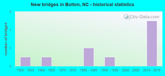
- New bridges - historical statistics
- 11950-1959
- 11960-1969
- 21980-1989
- 11990-1999
- 52010-2019


- Bridge Condition - Deck
- 33.3%Very good
- 50.0%Good
- 16.7%Satisfactory

- Bridge Condition - Superstructure
- 50.0%Very good
- 33.3%Good
- 16.7%Satisfactory

- Bridge Condition - Substructure
- 50.0%Very good
- 33.3%Good
- 16.7%Fair

- Bridge Condition - Channel
- 28.6%Very good
- 42.9%Good
- 14.3%Satisfactory
- 14.3%Fair

- Bridge Condition - Culverts
- 50.0%Good
- 50.0%Fair
Find on map >> Show street view
Structure Number: 47025, Location: 0.1 MI. SOUTH OF SR1801 (Lat: 34.348778, Lng: -78.408333), Route carried "on" structure: State highway 1800, Year Built: 1951, Status: Posted for load, Structure Length: 1.85m (6.07ft), Average Daily Traffic: 900 (year 2017), Truck Traffic: 6%, Average Future Daily Traffic: 1,800 (year 2025), Features Intersected: RICEFIELD BRANCH
Minimum Vertical Clearance: 30+ m (98+ ft), Kilometerpoint: 0.000, Lanes on structure: 2, Owner: State Highway Agency, Approaching Roadway Width: 5.4m (17.7ft), Material/Design: Steel, Design/Construction: Stringer/Multi-beam, Number Of Spans In Main Unit: 3, Length of Maximum Span: 6.0m (19.7ft), Curb or Sidewalk Widths: Left: 0.2m (0.7ft), Right: 0.2m (0.7ft), Curb-To-Curb Width: 7.3m (24.0ft), Out-to-Out Width: 8.3m (27.2ft)
Condition: Deck: Satisfactory, Superstructure: Satisfactory, Substructure: Fair, Channel: Good, Operating Rating: 45.3 metric tons, Method Used To Determine Operating Rating: Allowable Stress (AS), Inventory Rating: 17.2 metric tons, Method Used To Determine Inventory Rating: Allowable Stress (AS), Structural Evaluation: Meets minimum limits, Deck Geometry: Meets minimum limits, Waterway Adequacy: Better than present minimum criteria, Approach Roadway Alignment: Equal to present desirable criteria, Bridge Posting: Required (Relationship of Operating Rating to Maximum Legal Load: 0.1 - 9.9% below), Designated Inspection Frequency: Every 24 months, Underwater Inspection Frequency: Every 60 months, Inspection Date: August 2020, Underwater Inspection Date: March 2018, Deck Structure Type: Concrete Cast-file-Place, Wearing Surface/Protective System: Wearing Surface: Bituminous
Find on map >> Show street view
Structure Number: 470252, Location: .25MI.W. OF JCT.SR1802 (Lat: 34.375175, Lng: -78.421967), Route carried "on" structure: State highway 1740, Year Built: 1993, Status: Open, Structure Length: 1.15m (3.77ft), Average Daily Traffic: 1,700 (year 2019), Truck Traffic: 6%, Average Future Daily Traffic: 3,400 (year 2040), Design Load: HS 20+Mod, Features Intersected: BUCKHEAD BRANCH
Minimum Vertical Clearance: 30+ m (98+ ft), Kilometerpoint: 0.000, Lanes on structure: 2, Owner: State Highway Agency, Approaching Roadway Width: 6.4m (21.0ft), Material/Design: Steel, Design/Construction: Culvert, Number Of Spans In Main Unit: 3, Length of Maximum Span: 3.3m (10.8ft)
Condition: Channel: Satisfactory, Culverts: Good, Operating Rating: 89.8 metric tons, Method Used To Determine Operating Rating: Load and Resistance Factor (LRFR), Inventory Rating: 89.8 metric tons, Method Used To Determine Inventory Rating: Load and Resistance Factor (LRFR), Structural Evaluation: Better than present minimum criteria, Waterway Adequacy: Better than present minimum criteria, Approach Roadway Alignment: Equal to present desirable criteria, Designated Inspection Frequency: Every 24 months, Inspection Date: April 2021
Find on map >> Show street view
Structure Number: 470259, Location: 0.1 MILES NORTH OF SR1806 (Lat: 34.303969, Lng: -78.315239), Route carried "on" structure: State highway 1836, Year Built: 2018, Status: Open, Structure Length: 2.19m (7.19ft), Average Daily Traffic: 940 (year 2017), Truck Traffic: 6%, Average Future Daily Traffic: 1,880 (year 2025), Design Load: HL 93, Features Intersected: MILL CREEK
Minimum Vertical Clearance: 30+ m (98+ ft), Kilometerpoint: 0.000, Lanes on structure: 2, Owner: State Highway Agency, Approaching Roadway Width: 9.4m (30.8ft), Material/Design: Prestressed concrete, Design/Construction: Slab, Number Of Spans In Main Unit: 1, Length of Maximum Span: 20.7m (67.9ft), Curb-To-Curb Width: 9.2m (30.2ft), Out-to-Out Width: 10.0m (32.8ft)
Condition: Deck: Very good, Superstructure: Very good, Substructure: Very good, Channel: Very good, Operating Rating: 56.2 metric tons, Method Used To Determine Operating Rating: Load and Resistance Factor (LRFR), Inventory Rating: 41.7 metric tons, Method Used To Determine Inventory Rating: Load and Resistance Factor (LRFR), Structural Evaluation: Equal to present desirable criteria, Deck Geometry: Equal to present minimum criteria, Waterway Adequacy: Better than present minimum criteria, Approach Roadway Alignment: Equal to present desirable criteria, Designated Inspection Frequency: Every 24 months, Inspection Date: August 2020, Deck Structure Type: Concrete Precast Panels, Wearing Surface/Protective System: Wearing Surface: Bituminous
Find on map >> Show street view
Structure Number: 470262, Location: 1 MI. S. JCT. SR1806 (Lat: 34.288864, Lng: -78.318728), Route carried "on" structure: State highway 1836, Year Built: 2018, Status: Open, Structure Length: 2.19m (7.19ft), Average Daily Traffic: 940 (year 2017), Truck Traffic: 6%, Average Future Daily Traffic: 1,880 (year 2040), Design Load: HL 93, Features Intersected: DAN'S CREEK
Minimum Vertical Clearance: 30+ m (98+ ft), Kilometerpoint: 0.000, Lanes on structure: 2, Owner: State Highway Agency, Approaching Roadway Width: 5.7m (18.7ft), Material/Design: Prestressed concrete, Design/Construction: Slab, Number Of Spans In Main Unit: 1, Length of Maximum Span: 21.0m (68.9ft), Curb-To-Curb Width: 9.2m (30.2ft), Out-to-Out Width: 10.0m (32.8ft)
Condition: Deck: Very good, Superstructure: Very good, Substructure: Very good, Channel: Very good, Operating Rating: 56.2 metric tons, Method Used To Determine Operating Rating: Load and Resistance Factor (LRFR), Inventory Rating: 41.7 metric tons, Method Used To Determine Inventory Rating: Load and Resistance Factor (LRFR), Structural Evaluation: Equal to present desirable criteria, Deck Geometry: Equal to present minimum criteria, Waterway Adequacy: Better than present minimum criteria, Approach Roadway Alignment: Equal to present desirable criteria, Designated Inspection Frequency: Every 24 months, Inspection Date: August 2020, Deck Structure Type: Concrete Precast Panels
Find on map >> Show street view
Structure Number: 470375, Location: 1.7 MI.N.JCT.US74/US76 (Lat: 34.348008, Lng: -78.438519), Route carried "on" structure: State highway 211, Year Built: 1969, Status: Open, Structure Length: 1.76m (5.77ft), Average Daily Traffic: 2,400 (year 2019), Truck Traffic: 7%, Average Future Daily Traffic: 4,800 (year 2040), Design Load: HS 20+Mod, Features Intersected: FRIARS SWAMP
Minimum Vertical Clearance: 30+ m (98+ ft), Kilometerpoint: 0.000, Lanes on structure: 2, Owner: State Highway Agency, Approaching Roadway Width: 9.7m (31.8ft), Material/Design: Concrete continuous, Design/Construction: Culvert, Number Of Spans In Main Unit: 6, Length of Maximum Span: 2.7m (8.9ft)
Condition: Channel: Fair, Culverts: Fair, Operating Rating: 41.7 metric tons, Method Used To Determine Operating Rating: Field evaluation and documented engineering judgment, Inventory Rating: 32.6 metric tons, Method Used To Determine Inventory Rating: Field evaluation and documented engineering judgment, Structural Evaluation: Somewhat better than minimum adequacy, Waterway Adequacy: Better than present minimum criteria, Approach Roadway Alignment: Equal to present desirable criteria, Designated Inspection Frequency: Every 24 months, Underwater Inspection Frequency: Every 60 months, Inspection Date: March 2021, Underwater Inspection Date: March 2021
Find on map >> Show street view
Structure Number: 470387, Location: 2.1MI.W. OF JCT.NC211 (Lat: 34.322525, Lng: -78.454994), Route carried "on" structure: US 74, Year Built: 1988, Status: Open, Structure Length: 4.32m (14.17ft), Average Daily Traffic: 6,750 (year 2018), Truck Traffic: 14%, Average Future Daily Traffic: 13,500 (year 2040), Design Load: HS 20+Mod, Features Intersected: FRIAR SWAMP
Minimum Vertical Clearance: 30+ m (98+ ft), Kilometerpoint: 78.151, Lanes on structure: 2, Base Highway Network: Yes (Inventory Route: 2, Subroute: 74), Owner: State Highway Agency, Approaching Roadway Width: 10.9m (35.8ft), Skew: 10 degrees, Material/Design: Prestressed concrete, Design/Construction: Slab, Number Of Spans In Main Unit: 4, Length of Maximum Span: 10.0m (32.8ft), Curb-To-Curb Width: 10.9m (35.8ft), Out-to-Out Width: 11.8m (38.7ft)
Condition: Deck: Good, Superstructure: Good, Substructure: Good, Channel: Good, Operating Rating: 82.5 metric tons, Method Used To Determine Operating Rating: Load Factor (LF), Inventory Rating: 48.9 metric tons, Method Used To Determine Inventory Rating: Load Factor (LF), Structural Evaluation: Better than present minimum criteria, Deck Geometry: Somewhat better than minimum adequacy, Waterway Adequacy: Better than present minimum criteria, Approach Roadway Alignment: Equal to present desirable criteria, Designated Inspection Frequency: Every 24 months, Inspection Date: July 2020, Deck Structure Type: Concrete Precast Panels, Wearing Surface/Protective System: Wearing Surface: Bituminous
Find on map >> Show street view
Structure Number: 470388, Location: 2.1 MI.W. OF JCT.NC211 (Lat: 34.322333, Lng: -78.455014), Route carried "on" structure: US 74, Year Built: 1988, Status: Open, Structure Length: 4.32m (14.17ft), Average Daily Traffic: 6,750 (year 2018), Truck Traffic: 14%, Average Future Daily Traffic: 13,500 (year 2040), Design Load: HS 20+Mod, Features Intersected: FRIAR SWAMP
Minimum Vertical Clearance: 30+ m (98+ ft), Kilometerpoint: 78.151, Lanes on structure: 2, Base Highway Network: Yes (Inventory Route: 2, Subroute: 74), Owner: State Highway Agency, Approaching Roadway Width: 10.9m (35.8ft), Skew: 10 degrees, Material/Design: Prestressed concrete, Design/Construction: Slab, Number Of Spans In Main Unit: 4, Length of Maximum Span: 10.0m (32.8ft), Curb-To-Curb Width: 10.9m (35.8ft), Out-to-Out Width: 11.8m (38.7ft)
Condition: Deck: Good, Superstructure: Good, Substructure: Good, Channel: Good, Operating Rating: 81.6 metric tons, Method Used To Determine Operating Rating: Load Factor (LF), Inventory Rating: 48.9 metric tons, Method Used To Determine Inventory Rating: Load Factor (LF), Structural Evaluation: Better than present minimum criteria, Deck Geometry: Somewhat better than minimum adequacy, Waterway Adequacy: Better than present minimum criteria, Approach Roadway Alignment: Equal to present desirable criteria, Designated Inspection Frequency: Every 24 months, Inspection Date: July 2020, Deck Structure Type: Concrete Precast Panels, Wearing Surface/Protective System: Wearing Surface: Bituminous
Find on map >> Show street view
Structure Number: 470408, Location: 1.1 MI.N. OF JCT.NC 214 (Lat: 34.329228, Lng: -78.418975), Route carried "on" structure: State highway 211, Year Built: 2012, Status: Open, Structure Length: 6.18m (20.28ft), Average Daily Traffic: 2,100 (year 2013), Truck Traffic: 7%, Average Future Daily Traffic: 4,200 (year 2040), Design Load: HS 20+Mod, Features Intersected: US74/76
Minimum Vertical Clearance: 30+ m (98+ ft), Kilometerpoint: 0.000, Lanes on structure: 3, Lanes under structure: 4, Owner: State Highway Agency, Approaching Roadway Width: 15.8m (51.8ft), Skew: 2 degrees, Material/Design: Prestressed concrete continuous, Design/Construction: Stringer/Multi-beam, Number Of Spans In Main Unit: 2, Length of Maximum Span: 29.8m (97.8ft), Curb-To-Curb Width: 15.7m (51.5ft), Out-to-Out Width: 16.8m (55.1ft)
Condition: Deck: Good, Superstructure: Very good, Substructure: Very good, Operating Rating: 89.8 metric tons, Method Used To Determine Operating Rating: Load Factor (LF), Inventory Rating: 58.9 metric tons, Method Used To Determine Inventory Rating: Load Factor (LF), Structural Evaluation: Equal to present desirable criteria, Deck Geometry: Better than present minimum criteria, Underclear: Meets minimum limits, Approach Roadway Alignment: Equal to present desirable criteria, Designated Inspection Frequency: Every 24 months, Inspection Date: July 2020, Deck Structure Type: Concrete Cast-file-Place, Wearing Surface/Protective System: Wearing Surface: Monolithic Concrete, Deck Protection: Epoxy Coated Reinforcing
Find on map >> Show street view
Structure Number: 470408, Location: 1.1 MI.N. OF JCT.NC 214 (Lat: 34.329228, Lng: -78.418975), Route carried "under" structure: US 74, Year Built: 2012, Structure Length: 0. m, Average Daily Traffic: 6,000 (year 2013), Truck Traffic: 14%, Features Intersected: NC 211
Minimum Vertical Clearance: 5.30m (17.39ft), Kilometerpoint: 78.822, Lanes on structure: 3, Lanes under structure: 2, Material/Design: Prestressed concrete continuous, Design/Construction: Stringer/Multi-beam, Length of Maximum Span: 29.8m (97.8ft)
Find on map >> Show street view
Structure Number: 470408, Location: 1.1 MI.N. OF JCT.NC 214 (Lat: 34.329228, Lng: -78.418975), Route carried "under" structure: US 74, Year Built: 2012, Structure Length: 0. m, Average Daily Traffic: 6,000 (year 2013), Truck Traffic: 14%, Features Intersected: NC 211
Minimum Vertical Clearance: 5.46m (17.91ft), Kilometerpoint: 78.822, Lanes on structure: 3, Lanes under structure: 2, Material/Design: Prestressed concrete continuous, Design/Construction: Stringer/Multi-beam, Length of Maximum Span: 29.8m (97.8ft)