Bridge Statistics for Bonner Springs, Kansas (KS)
Condition, Traffic, Stress, Structural Evaluation, Project Costs
- National Bridge Inventory (NBI) Statistics
- 43Number of bridges
- 991ft / 302mTotal length
- 363,096Total average daily traffic
- 55,075Total average daily truck traffic
- National Bridge Inventory (NBI) Registered Bridges for Bonner Springs
- No street view available for this location
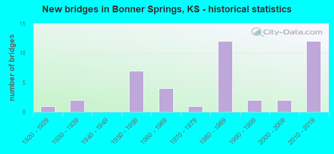
- New bridges - historical statistics
- 11920-1929
- 21930-1939
- 71950-1959
- 41960-1969
- 11970-1979
- 121980-1989
- 21990-1999
- 22000-2009
- 122010-2019
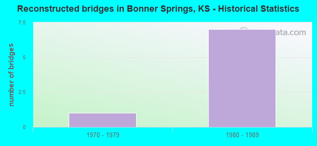
- Reconstructed bridges - Historical Statistics
- 11970-1979
- 71980-1989
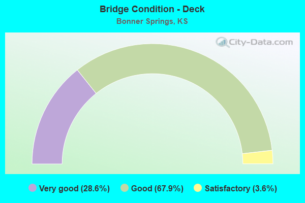
- Bridge Condition - Deck
- 28.6%Very good
- 67.9%Good
- 3.6%Satisfactory
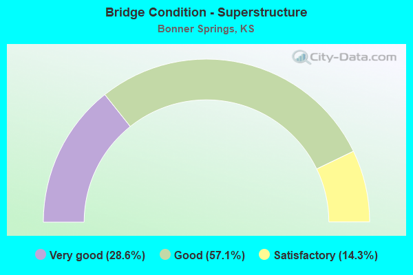
- Bridge Condition - Superstructure
- 28.6%Very good
- 57.1%Good
- 14.3%Satisfactory
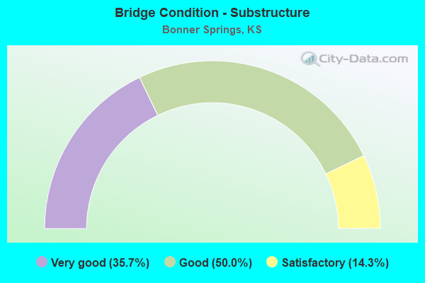
- Bridge Condition - Substructure
- 35.7%Very good
- 50.0%Good
- 14.3%Satisfactory
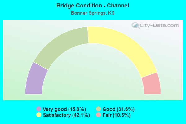
- Bridge Condition - Channel
- 15.8%Very good
- 31.6%Good
- 42.1%Satisfactory
- 10.5%Fair
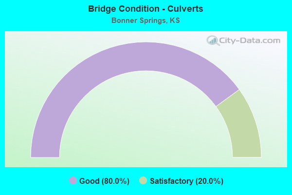
- Bridge Condition - Culverts
- 80.0%Good
- 20.0%Satisfactory
Find on map >> Show street view
Structure Number: 3043, Location: 1.0N OF LARKINBURG (Lat: 39.474081, Lng: -95.570269), Route carried "on" structure: County highway 1592, Year Built: 1964, Status: Posted for load, Structure Length: 7.01m (23.00ft), Average Daily Traffic: 60 (year 2007), Average Future Daily Traffic: 60 (year 2040), Design Load: H 15, Features Intersected: ELK CREEK
Minimum Vertical Clearance: 30.47m (99.97ft), Kilometerpoint: 1.000, Lanes on structure: 2, Owner: County Highway Agency, Approaching Roadway Width: 5.6m (18.4ft), Material/Design: Steel continuous, Design/Construction: Stringer/Multi-beam, Number Of Spans In Main Unit: 3, Length of Maximum Span: 25.6m (84.0ft), Curb or Sidewalk Widths: Left: 0.3m (1.0ft), Right: 0.3m (1.0ft), Curb-To-Curb Width: 7.3m (24.0ft), Out-to-Out Width: 8.0m (26.2ft)
Condition: Deck: Good, Superstructure: Good, Substructure: Very good, Channel: Satisfactory, Operating Rating: 30.4 metric tons, Method Used To Determine Operating Rating: Load Factor (LF), Inventory Rating: 18.1 metric tons, Method Used To Determine Inventory Rating: Load Factor (LF), Structural Evaluation: Somewhat better than minimum adequacy, Deck Geometry: Equal to present minimum criteria, Waterway Adequacy: Better than present minimum criteria, Approach Roadway Alignment: Equal to present desirable criteria, Designated Inspection Frequency: Every 24 months, Inspection Date: July 2020, Deck Structure Type: Other, Wearing Surface/Protective System: Wearing Surface: Monolithic Concrete
Find on map >> Show street view
Structure Number: 52107560432, Location: 3.0N 4.6E OF LINWOOD (Lat: 39.043594, Lng: -94.953592), Route carried "on" structure: County highway , Year Built: 1987, Status: Open, Structure Length: 0.94m (3.08ft), Average Daily Traffic: 125 (year 2013), Truck Traffic: 16%, Average Future Daily Traffic: 206 (year 2038), Features Intersected: LITTLE KAW CREEK, Facility Carried by Structure: SH-11 STILLWELL RD
Minimum Vertical Clearance: 30.47m (99.97ft), Kilometerpoint: 0.000, Lanes on structure: 2, Owner: County Highway Agency, Approaching Roadway Width: 6.0m (19.7ft), Material/Design: Steel, Design/Construction: Stringer/Multi-beam, Number Of Spans In Main Unit: 1, Length of Maximum Span: 9.0m (29.5ft), Curb-To-Curb Width: 7.2m (23.6ft), Out-to-Out Width: 7.3m (24.0ft)
Condition: Deck: Good, Superstructure: Satisfactory, Substructure: Satisfactory, Channel: Satisfactory, Operating Rating: 45.9 metric tons, Method Used To Determine Operating Rating: Allowable Stress (AS), Inventory Rating: 34.2 metric tons, Method Used To Determine Inventory Rating: Allowable Stress (AS), Structural Evaluation: Equal to present minimum criteria, Deck Geometry: Meets minimum limits, Waterway Adequacy: Equal to present minimum criteria, Approach Roadway Alignment: Equal to present desirable criteria, Designated Inspection Frequency: Every 24 months, Inspection Date: March 2020, Deck Structure Type: Corrugated Steel, Wearing Surface/Protective System: Wearing Surface: Bituminous
Find on map >> Show street view
Structure Number: 52107950426, Location: 2.0S OF S.E. COR. BASEHOR (Lat: 39.086950, Lng: -94.918153), Route carried "on" structure: County highway , Year Built: 1988, Status: Open, Structure Length: 3.75m (12.30ft), Average Daily Traffic: 1,535 (year 2013), Truck Traffic: 11%, Average Future Daily Traffic: 1,719 (year 2038), Design Load: HS 20, Features Intersected: WOLF CREEK, Facility Carried by Structure: F-53 KANSAS AVE.
Minimum Vertical Clearance: 30.47m (99.97ft), Kilometerpoint: 0.000, Lanes on structure: 2, Owner: County Highway Agency, Approaching Roadway Width: 7.4m (24.3ft), Material/Design: Concrete continuous, Design/Construction: Slab, Number Of Spans In Main Unit: 3, Length of Maximum Span: 14.6m (47.9ft), Curb-To-Curb Width: 7.3m (24.0ft), Out-to-Out Width: 7.9m (25.9ft)
Condition: Deck: Good, Superstructure: Good, Substructure: Good, Channel: Satisfactory, Operating Rating: 63.9 metric tons, Method Used To Determine Operating Rating: Load Factor (LF), Inventory Rating: 36.0 metric tons, Method Used To Determine Inventory Rating: Load Factor (LF), Structural Evaluation: Better than present minimum criteria, Deck Geometry: Meets minimum limits, Waterway Adequacy: Equal to present desirable criteria, Approach Roadway Alignment: Equal to present desirable criteria, Designated Inspection Frequency: Every 24 months, Inspection Date: March 2020, Deck Structure Type: Concrete Cast-file-Place
Find on map >> Show street view
Structure Number: 52107970428, Location: 3.0S OF S.E. COR. BASEHOR (Lat: 39.073364, Lng: -94.915839), Route carried "on" structure: County highway , Year Built: 1963, Status: Posted for load, Structure Length: 3.25m (10.66ft), Average Daily Traffic: 540 (year 2006), Truck Traffic: 16%, Average Future Daily Traffic: 567 (year 2038), Design Load: H 15, Features Intersected: WOLF CREEK, Facility Carried by Structure: F-55 METRO AVE.
Minimum Vertical Clearance: 30.47m (99.97ft), Kilometerpoint: 0.000, Lanes on structure: 2, Owner: County Highway Agency, Approaching Roadway Width: 7.9m (25.9ft), Material/Design: Concrete continuous, Design/Construction: Tee Beam, Number Of Spans In Main Unit: 3, Length of Maximum Span: 12.2m (40.0ft), Curb-To-Curb Width: 7.3m (24.0ft), Out-to-Out Width: 7.9m (25.9ft)
Condition: Deck: Good, Superstructure: Good, Substructure: Good, Channel: Satisfactory, Operating Rating: 27.9 metric tons, Method Used To Determine Operating Rating: Load Factor (LF), Inventory Rating: 15.3 metric tons, Method Used To Determine Inventory Rating: Load Factor (LF), Structural Evaluation: Meets minimum limits, Deck Geometry: Meets minimum limits, Waterway Adequacy: Equal to present desirable criteria, Approach Roadway Alignment: Better than present minimum criteria, Bridge Posting: Required (Relationship of Operating Rating to Maximum Legal Load: 20.0 - 29.9% below), Designated Inspection Frequency: Every 24 months, Inspection Date: March 2020, Deck Structure Type: Concrete Cast-file-Place
Find on map >> Show street view
Structure Number: 1051081004329, Location: 142ND ST N OF KREIDER (Lat: 39.030014, Lng: -94.908822), Route carried "on" structure: City street , Year Built: 2007, Status: Open, Structure Length: 3.12m (10.24ft), Average Daily Traffic: 765 (year 2007), Truck Traffic: 10%, Average Future Daily Traffic: 380 (year 2043), Design Load: HL 93, Features Intersected: LITTLE KAW CREEK, Facility Carried by Structure: 142ND STREET
Minimum Vertical Clearance: 30.47m (99.97ft), Kilometerpoint: 0.000, Lanes on structure: 2, Owner: County Highway Agency, Approaching Roadway Width: 5.4m (17.7ft), Material/Design: Concrete continuous, Design/Construction: Slab, Number Of Spans In Main Unit: 3, Length of Maximum Span: 12.2m (40.0ft), Curb-To-Curb Width: 8.5m (27.9ft), Out-to-Out Width: 9.1m (29.9ft)
Condition: Deck: Good, Superstructure: Good, Substructure: Good, Channel: Good, Operating Rating: 61.6 metric tons, Method Used To Determine Operating Rating: Load and Resistance Factor Rating (LRFR) rating reported by rating factor(RF) method using HL-93 loadings, Inventory Rating: 47.6 metric tons, Method Used To Determine Inventory Rating: Load and Resistance Factor Rating (LRFR) rating reported by rating factor(RF) method using HL-93 loadings, Structural Evaluation: Better than present minimum criteria, Deck Geometry: Somewhat better than minimum adequacy, Waterway Adequacy: Better than present minimum criteria, Approach Roadway Alignment: Equal to present desirable criteria, Designated Inspection Frequency: Every 24 months, Inspection Date: March 2021, Other Special Inspection Date: November 2020, Deck Structure Type: Concrete Cast-file-Place, Wearing Surface/Protective System: Deck Protection: Epoxy Coated Reinforcing
Find on map >> Show street view
Structure Number: 403001050000004, Location: BONNER SPRINGS (Lat: 39.047853, Lng: -94.889489), Route carried "on" structure: City street 355, Year Built: 1977, Status: Open, Structure Length: 5.53m (18.14ft), Average Daily Traffic: 2,020 (year 2018), Truck Traffic: 5%, Average Future Daily Traffic: 2,080 (year 2039), Design Load: HS 20, Features Intersected: WOLF CREEK, Facility Carried by Structure: LORING AVE.
Minimum Vertical Clearance: 30.47m (99.97ft), Kilometerpoint: 0.000, Lanes on structure: 2, Owner: City or Municipal Highway Agency, Approaching Roadway Width: 15.5m (50.9ft), Material/Design: Prestressed concrete continuous, Design/Construction: Tee Beam, Number Of Spans In Main Unit: 3, Length of Maximum Span: 18.6m (61.0ft), Curb-To-Curb Width: 15.8m (51.8ft), Out-to-Out Width: 16.5m (54.1ft)
Condition: Deck: Satisfactory, Superstructure: Good, Substructure: Good, Channel: Good, Operating Rating: 28.3 metric tons, Method Used To Determine Operating Rating: Load Factor (LF), Inventory Rating: 17.0 metric tons, Method Used To Determine Inventory Rating: Load Factor (LF), Structural Evaluation: Meets minimum limits, Deck Geometry: Superior to present desirable criteria, Waterway Adequacy: Equal to present desirable criteria, Approach Roadway Alignment: Better than present minimum criteria, Designated Inspection Frequency: Every 24 months, Inspection Date: March 2021, Deck Structure Type: Concrete Cast-file-Place, Wearing Surface/Protective System: Wearing Surface: Monolithic Concrete, Deck Protection: Epoxy Coated Reinforcing
Find on map >> Show street view
Structure Number: 503001050000001, Location: 0.05 MILES NORTH OF K-32 (Lat: 39.065383, Lng: -94.878550), Route carried "on" structure: City street , Year Built: 1997, Status: Open, Structure Length: 1.52m (4.99ft), Average Daily Traffic: 175 (year 2018), Truck Traffic: 50%, Average Future Daily Traffic: 214 (year 2039), Design Load: HS 20, Features Intersected: MISSION CREEK, Facility Carried by Structure: 121ST STREET
Minimum Vertical Clearance: 30.47m (99.97ft), Kilometerpoint: 0.000, Lanes on structure: 2, Owner: City or Municipal Highway Agency, Approaching Roadway Width: 12.1m (39.7ft), Material/Design: Concrete, Design/Construction: Culvert, Number Of Spans In Main Unit: 4, Length of Maximum Span: 3.7m (12.1ft), Curb or Sidewalk Widths: Left: 1.2m (3.9ft), Right: 0.0m
Condition: Channel: Satisfactory, Culverts: Good, Operating Rating: 54.4 metric tons, Method Used To Determine Operating Rating: Field evaluation and documented engineering judgment, Inventory Rating: 32.7 metric tons, Method Used To Determine Inventory Rating: Field evaluation and documented engineering judgment, Structural Evaluation: Better than present minimum criteria, Waterway Adequacy: Equal to present minimum criteria, Approach Roadway Alignment: Equal to present desirable criteria, Designated Inspection Frequency: Every 24 months, Inspection Date: March 2021
Find on map >> Show street view
Structure Number: 503001050000003, Location: SOUTH OF K-32 (Lat: 39.050775, Lng: -94.911767), Route carried "on" structure: City street , Year Built: 2009, Status: Open, Structure Length: 3.63m (11.91ft), Average Daily Traffic: 250 (year 2018), Truck Traffic: 1%, Average Future Daily Traffic: 250 (year 2039), Design Load: HL 93, Features Intersected: WOLF CREEK, Facility Carried by Structure: WOODEND ROAD
Minimum Vertical Clearance: 30.47m (99.97ft), Kilometerpoint: 0.000, Lanes on structure: 2, Owner: City or Municipal Highway Agency, Approaching Roadway Width: 7.9m (25.9ft), Skew: 1 degrees, Material/Design: Prestressed concrete continuous, Design/Construction: Stringer/Multi-beam, Number Of Spans In Main Unit: 3, Length of Maximum Span: 13.5m (44.3ft), Curb or Sidewalk Widths: Left: 1.5m (4.9ft), Right: 0.0m, Curb-To-Curb Width: 8.5m (27.9ft), Out-to-Out Width: 11.0m (36.1ft)
Condition: Deck: Good, Superstructure: Very good, Substructure: Very good, Channel: Very good, Operating Rating: 61.9 metric tons, Method Used To Determine Operating Rating: Field evaluation and documented engineering judgment, Inventory Rating: 37.0 metric tons, Method Used To Determine Inventory Rating: Field evaluation and documented engineering judgment, Structural Evaluation: Equal to present desirable criteria, Deck Geometry: Equal to present minimum criteria, Waterway Adequacy: Equal to present desirable criteria, Approach Roadway Alignment: Equal to present minimum criteria, Designated Inspection Frequency: Every 24 months, Inspection Date: March 2021, Deck Structure Type: Concrete Cast-file-Place, Wearing Surface/Protective System: Wearing Surface: Monolithic Concrete, Deck Protection: Epoxy Coated Reinforcing
Find on map >> Show street view
Structure Number: 503001050000005, Location: 0.3 M NORTH OF KREIDER (Lat: 39.025119, Lng: -94.899511), Route carried "on" structure: City street 387, Year Built: 1922, Year Reconstructed: 1976, Status: Open, Structure Length: 0.99m (3.25ft), Average Daily Traffic: 2,020 (year 2018), Truck Traffic: 5%, Average Future Daily Traffic: 2,080 (year 2039), Design Load: H 15, Features Intersected: LITTLE KAW CREEK, Facility Carried by Structure: LORING AVE.
Minimum Vertical Clearance: 30.47m (99.97ft), Kilometerpoint: 1.609, Lanes on structure: 2, Owner: City or Municipal Highway Agency, Approaching Roadway Width: 7.3m (24.0ft), Material/Design: Concrete, Design/Construction: Culvert, Number Of Spans In Main Unit: 2, Length of Maximum Span: 4.8m (15.7ft)
Condition: Channel: Fair, Culverts: Satisfactory, Operating Rating: 54.4 metric tons, Method Used To Determine Operating Rating: Field evaluation and documented engineering judgment, Inventory Rating: 32.7 metric tons, Method Used To Determine Inventory Rating: Field evaluation and documented engineering judgment, Structural Evaluation: Equal to present minimum criteria, Waterway Adequacy: Equal to present minimum criteria, Approach Roadway Alignment: Equal to present desirable criteria, Designated Inspection Frequency: Every 24 months, Inspection Date: March 2021
Find on map >> Show street view
Structure Number: 999900100170141, Location: 7.43 MI N OKLA STATE LINE (Lat: 37.106667, Lng: -99.325000), Route carried "on" structure: State highway 1, Year Built: 1935, Status: Open, Structure Length: 2.35m (7.71ft), Average Daily Traffic: 687 (year 2020), Truck Traffic: 45%, Average Future Daily Traffic: 1,021 (year 2041), Design Load: H 15, Features Intersected: SALT FORK ARKANSAS RIVER
Minimum Vertical Clearance: 30.47m (99.97ft), Kilometerpoint: 11.949, Lanes on structure: 2, Owner: State Highway Agency, Approaching Roadway Width: 7.3m (24.0ft), Material/Design: Concrete, Design/Construction: Culvert, Number Of Spans In Main Unit: 6, Length of Maximum Span: 3.7m (12.1ft), Curb-To-Curb Width: 9.8m (32.2ft), Out-to-Out Width: 10.5m (34.4ft)
Condition: Channel: Fair, Culverts: Good, Operating Rating: 58.1 metric tons, Method Used To Determine Operating Rating: Load Factor (LF), Inventory Rating: 34.5 metric tons, Method Used To Determine Inventory Rating: Load Factor (LF), Structural Evaluation: Better than present minimum criteria, Deck Geometry: Equal to present minimum criteria, Waterway Adequacy: High priority of corrective action, Approach Roadway Alignment: Better than present minimum criteria, Length Of Structure Improvement: 7.71m (25.30ft), Designated Inspection Frequency: Every 24 months, Inspection Date: September 2021, Deck Structure Type: Concrete Cast-file-Place, Wearing Surface/Protective System: Wearing Surface: Bituminous
Find on map >> Show street view
Structure Number: 999900701050771, Location: 0.03 MI N JOHNSON COLN (Lat: 39.059444, Lng: -94.871667), Route carried "on" structure: State highway 7, Year Built: 1960, Year Reconstructed: 1987, Status: Open, Structure Length: 63.36m (207.87ft), Average Daily Traffic: 10,809 (year 2020), Truck Traffic: 10%, Average Future Daily Traffic: 17,712 (year 2041), Design Load: HS 20, Features Intersected: RIV,RR,K32 HWY, ACC RD
Minimum Vertical Clearance: 30.47m (99.97ft), Kilometerpoint: 38.769, Lanes on structure: 2, Lanes under structure: 6, Base Highway Network: Yes, Owner: State Highway Agency, Approaching Roadway Width: 12.2m (40.0ft), Material/Design: Steel continuous, Design/Construction: Stringer/Multi-beam, Number Of Spans In Main Unit: 9, Number Of Approach Spans: 7, Length of Maximum Span: 56.1m (184.1ft), Curb-To-Curb Width: 12.2m (40.0ft), Out-to-Out Width: 13.0m (42.7ft)
Condition: Deck: Good, Superstructure: Satisfactory, Substructure: Satisfactory, Channel: Satisfactory, Operating Rating: 70.1 metric tons, Method Used To Determine Operating Rating: Load Factor (LF), Inventory Rating: 42.0 metric tons, Method Used To Determine Inventory Rating: Load Factor (LF), Structural Evaluation: Equal to present minimum criteria, Deck Geometry: Better than present minimum criteria, Underclear: Meets minimum limits, Waterway Adequacy: Better than present minimum criteria, Approach Roadway Alignment: Equal to present desirable criteria, Length Of Structure Improvement: 207.86m (681.96ft), Designated Inspection Frequency: Every 24 months, Underwater Inspection Frequency: Every 60 months, Inspection Date: September 2021, Underwater Inspection Date: October 2020, Deck Structure Type: Concrete Cast-file-Place, Wearing Surface/Protective System: Wearing Surface: Epoxy Overlay
Find on map >> Show street view
Structure Number: 999900701052581, Location: 0.03 MI N JOHNSON COLN (Lat: 39.059444, Lng: -94.871667), Route carried "on" structure: State highway 7, Year Built: 1985, Status: Open, Structure Length: 63.36m (207.87ft), Average Daily Traffic: 10,809 (year 2020), Truck Traffic: 10%, Average Future Daily Traffic: 17,712 (year 2041), Design Load: HS 20, Features Intersected: RIV, RR,K32 HWY, ACC RD
Minimum Vertical Clearance: 30.47m (99.97ft), Kilometerpoint: 38.751, Lanes on structure: 2, Lanes under structure: 6, Base Highway Network: Yes, Owner: State Highway Agency, Approaching Roadway Width: 12.2m (40.0ft), Material/Design: Steel continuous, Design/Construction: Stringer/Multi-beam, Number Of Spans In Main Unit: 11, Number Of Approach Spans: 5, Length of Maximum Span: 56.1m (184.1ft), Curb-To-Curb Width: 12.2m (40.0ft), Out-to-Out Width: 16.4m (53.8ft)
Condition: Deck: Very good, Superstructure: Good, Substructure: Good, Channel: Satisfactory, Operating Rating: 79.0 metric tons, Method Used To Determine Operating Rating: Load Factor (LF), Inventory Rating: 47.3 metric tons, Method Used To Determine Inventory Rating: Load Factor (LF), Structural Evaluation: Better than present minimum criteria, Deck Geometry: Better than present minimum criteria, Underclear: Meets minimum limits, Waterway Adequacy: Better than present minimum criteria, Approach Roadway Alignment: Equal to present desirable criteria, Length Of Structure Improvement: 207.88m (682.02ft), Designated Inspection Frequency: Every 24 months, Underwater Inspection Frequency: Every 60 months, Inspection Date: June 2021, Underwater Inspection Date: October 2020, Deck Structure Type: Concrete Cast-file-Place, Wearing Surface/Protective System: Wearing Surface: Epoxy Overlay
Find on map >> Show street view
Structure Number: 999900701052591, Location: 0.34 MI NW K32 (Lat: 39.065000, Lng: -94.876667), Route carried "on" structure: State highway 7, Year Built: 1984, Status: Open, Structure Length: 4.35m (14.27ft), Average Daily Traffic: 10,708 (year 2020), Truck Traffic: 8%, Average Future Daily Traffic: 17,546 (year 2041), Design Load: HS 20, Features Intersected: MORSE AVENUE
Minimum Vertical Clearance: 30.47m (99.97ft), Kilometerpoint: 0.797, Lanes on structure: 2, Lanes under structure: 2, Base Highway Network: Yes, Owner: State Highway Agency, Approaching Roadway Width: 12.2m (40.0ft), Skew: 1 degrees, Material/Design: Concrete continuous, Design/Construction: Slab, Number Of Spans In Main Unit: 3, Length of Maximum Span: 17.1m (56.1ft), Curb-To-Curb Width: 13.0m (42.7ft), Out-to-Out Width: 13.5m (44.3ft)
Condition: Deck: Good, Superstructure: Good, Substructure: Very good, Operating Rating: 80.7 metric tons, Method Used To Determine Operating Rating: Load Factor (LF), Inventory Rating: 48.1 metric tons, Method Used To Determine Inventory Rating: Load Factor (LF), Structural Evaluation: Better than present minimum criteria, Deck Geometry: Superior to present desirable criteria, Underclear: Better than present minimum criteria, Approach Roadway Alignment: Somewhat better than minimum adequacy, Length Of Structure Improvement: 14.26m (46.78ft), Designated Inspection Frequency: Every 24 months, Inspection Date: June 2021, Deck Structure Type: Concrete Cast-file-Place, Wearing Surface/Protective System: Wearing Surface: Low Slump Concrete
Find on map >> Show street view
Structure Number: 999900701052601, Location: 0.33 MI NW K32 (Lat: 39.065278, Lng: -94.876389), Route carried "on" structure: State highway 7, Year Built: 1984, Status: Open, Structure Length: 4.35m (14.27ft), Average Daily Traffic: 10,708 (year 2020), Truck Traffic: 8%, Average Future Daily Traffic: 17,546 (year 2041), Design Load: HS 20, Features Intersected: MORSE AVENUE
Minimum Vertical Clearance: 30.47m (99.97ft), Kilometerpoint: 0.792, Lanes on structure: 3, Lanes under structure: 2, Base Highway Network: Yes, Owner: State Highway Agency, Approaching Roadway Width: 12.2m (40.0ft), Skew: 1 degrees, Material/Design: Concrete continuous, Design/Construction: Slab, Number Of Spans In Main Unit: 3, Length of Maximum Span: 17.1m (56.1ft), Curb-To-Curb Width: 17.0m (55.8ft), Out-to-Out Width: 17.4m (57.1ft)
Condition: Deck: Good, Superstructure: Good, Substructure: Very good, Operating Rating: 80.7 metric tons, Method Used To Determine Operating Rating: Load Factor (LF), Inventory Rating: 48.1 metric tons, Method Used To Determine Inventory Rating: Load Factor (LF), Structural Evaluation: Better than present minimum criteria, Deck Geometry: Equal to present minimum criteria, Underclear: Equal to present desirable criteria, Approach Roadway Alignment: Equal to present desirable criteria, Length Of Structure Improvement: 14.26m (46.78ft), Designated Inspection Frequency: Every 24 months, Inspection Date: June 2021, Deck Structure Type: Concrete Cast-file-Place, Wearing Surface/Protective System: Wearing Surface: Low Slump Concrete
Find on map >> Show street view
Structure Number: 999900701052611, Location: 1.03 MI NW K32 (Lat: 39.074722, Lng: -94.880278), Route carried "on" structure: City street 359, Year Built: 1985, Status: Open, Structure Length: 8.45m (27.72ft), Average Daily Traffic: 4,792 (year 2020), Truck Traffic: 7%, Average Future Daily Traffic: 5,847 (year 2041), Design Load: HS 20, Features Intersected: K-7 HWY EL-WL, Facility Carried by Structure: NETTLETON AVENUE
Minimum Vertical Clearance: 30.47m (99.97ft), Kilometerpoint: 2.031, Lanes on structure: 2, Lanes under structure: 4, Owner: State Highway Agency, Approaching Roadway Width: 11.0m (36.1ft), Skew: 1 degrees, Material/Design: Steel continuous, Design/Construction: Stringer/Multi-beam, Number Of Spans In Main Unit: 3, Length of Maximum Span: 41.8m (137.1ft), Curb or Sidewalk Widths: Left: 0.0m, Right: 1.4m (4.6ft), Curb-To-Curb Width: 11.0m (36.1ft), Out-to-Out Width: 13.6m (44.6ft)
Condition: Deck: Good, Superstructure: Good, Substructure: Good, Operating Rating: 42.5 metric tons, Method Used To Determine Operating Rating: Load Factor (LF), Inventory Rating: 25.4 metric tons, Method Used To Determine Inventory Rating: Load Factor (LF), Structural Evaluation: Equal to present minimum criteria, Deck Geometry: Somewhat better than minimum adequacy, Underclear: Somewhat better than minimum adequacy, Approach Roadway Alignment: Meets minimum limits, Length Of Structure Improvement: 27.71m (90.91ft), Designated Inspection Frequency: Every 24 months, Inspection Date: June 2021, Wearing Surface/Protective System: Wearing Surface: Low Slump Concrete, Deck Protection: Epoxy Coated Reinforcing
Find on map >> Show street view
Structure Number: 999902000070251, Location: 2.13 MI E US75 (Lat: 39.667222, Lng: -95.690833), Route carried "on" structure: State highway 20, Year Built: 1935, Status: Open, Structure Length: 0.96m (3.15ft), Average Daily Traffic: 1,460 (year 2020), Truck Traffic: 15%, Average Future Daily Traffic: 1,966 (year 2041), Design Load: H 15, Features Intersected: DELAWARE RIVER DRAINAGE
Minimum Vertical Clearance: 30.47m (99.97ft), Kilometerpoint: 3.404, Lanes on structure: 2, Base Highway Network: Yes, Owner: State Highway Agency, Approaching Roadway Width: 7.3m (24.0ft), Material/Design: Concrete, Design/Construction: Culvert, Number Of Spans In Main Unit: 3, Length of Maximum Span: 3.0m (9.8ft), Curb-To-Curb Width: 9.8m (32.2ft), Out-to-Out Width: 10.5m (34.4ft)
Condition: Channel: Good, Culverts: Good, Operating Rating: 28.9 metric tons, Method Used To Determine Operating Rating: Load Factor (LF), Inventory Rating: 17.3 metric tons, Method Used To Determine Inventory Rating: Load Factor (LF), Structural Evaluation: Meets minimum limits, Deck Geometry: Somewhat better than minimum adequacy, Waterway Adequacy: Somewhat better than minimum adequacy, Approach Roadway Alignment: Better than present minimum criteria, Length Of Structure Improvement: 3.16m (10.37ft), Designated Inspection Frequency: Every 24 months, Inspection Date: May 2021, Deck Structure Type: Concrete Cast-file-Place, Wearing Surface/Protective System: Wearing Surface: Bituminous
Find on map >> Show street view
Structure Number: 999902401052621, Location: JCT US24/K7/I70 (KTA) (Lat: 39.096667, Lng: -94.881667), Route carried "on" structure: US 24, Year Built: 1985, Status: Open, Structure Length: 8.32m (27.30ft), Average Daily Traffic: 12,981 (year 2020), Truck Traffic: 6%, Average Future Daily Traffic: 21,271 (year 2041), Design Load: HS 20, Features Intersected: I-70 HIGHWAY(KTA)
Minimum Vertical Clearance: 30.47m (99.97ft), Kilometerpoint: 3.758, Lanes on structure: 2, Lanes under structure: 4, Base Highway Network: Yes, Owner: State Highway Agency, Approaching Roadway Width: 12.2m (40.0ft), Skew: 1 degrees, Material/Design: Steel continuous, Design/Construction: Stringer/Multi-beam, Number Of Spans In Main Unit: 3, Length of Maximum Span: 41.1m (134.8ft), Curb-To-Curb Width: 12.9m (42.3ft), Out-to-Out Width: 13.3m (43.6ft)
Condition: Deck: Good, Superstructure: Satisfactory, Substructure: Good, Operating Rating: 89.8 metric tons, Method Used To Determine Operating Rating: Load Factor (LF), Inventory Rating: 53.5 metric tons, Method Used To Determine Inventory Rating: Load Factor (LF), Structural Evaluation: Equal to present minimum criteria, Deck Geometry: Superior to present desirable criteria, Underclear: Somewhat better than minimum adequacy, Approach Roadway Alignment: Equal to present desirable criteria, Length Of Structure Improvement: 27.31m (89.60ft), Designated Inspection Frequency: Every 24 months, Inspection Date: June 2021, Wearing Surface/Protective System: Wearing Surface: Low Slump Concrete, Deck Protection: Epoxy Coated Reinforcing
Find on map >> Show street view
Structure Number: 999902401052631, Location: JCT US24/K7/I70 (KTA) (Lat: 39.096667, Lng: -94.881667), Route carried "on" structure: US 24, Year Built: 1985, Status: Open, Structure Length: 8.32m (27.30ft), Average Daily Traffic: 12,981 (year 2020), Truck Traffic: 6%, Average Future Daily Traffic: 21,271 (year 2041), Design Load: HS 20, Features Intersected: I-70 HIGHWAY(KTA)
Minimum Vertical Clearance: 30.47m (99.97ft), Kilometerpoint: 0.377, Lanes on structure: 2, Lanes under structure: 4, Base Highway Network: Yes (Inventory Route: 10520024, Subroute: 2), Owner: State Highway Agency, Approaching Roadway Width: 12.2m (40.0ft), Skew: 1 degrees, Material/Design: Steel continuous, Design/Construction: Stringer/Multi-beam, Number Of Spans In Main Unit: 3, Length of Maximum Span: 41.1m (134.8ft), Curb-To-Curb Width: 14.1m (46.3ft), Out-to-Out Width: 14.5m (47.6ft)
Condition: Deck: Good, Superstructure: Satisfactory, Substructure: Good, Operating Rating: 68.0 metric tons, Method Used To Determine Operating Rating: Load Factor (LF), Inventory Rating: 40.8 metric tons, Method Used To Determine Inventory Rating: Load Factor (LF), Structural Evaluation: Equal to present minimum criteria, Deck Geometry: Superior to present desirable criteria, Underclear: Equal to present minimum criteria, Approach Roadway Alignment: Equal to present desirable criteria, Length Of Structure Improvement: 27.31m (89.60ft), Designated Inspection Frequency: Every 24 months, Inspection Date: June 2021, Wearing Surface/Protective System: Wearing Surface: Low Slump Concrete, Deck Protection: Epoxy Coated Reinforcing
Find on map >> Show street view
Structure Number: 999903201052881, Location: 0.36 MI E LEAVENWORTH C/L (Lat: 39.057778, Lng: -94.901944), Route carried "on" structure: State highway 32, Year Built: 1993, Status: Open, Structure Length: 4.65m (15.26ft), Average Daily Traffic: 3,855 (year 2020), Truck Traffic: 5%, Average Future Daily Traffic: 4,894 (year 2041), Design Load: HS 20, Features Intersected: WOLF CREEK
Minimum Vertical Clearance: 30.47m (99.97ft), Kilometerpoint: 0.573, Lanes on structure: 2, Owner: State Highway Agency, Approaching Roadway Width: 13.4m (44.0ft), Material/Design: Concrete continuous, Design/Construction: Slab, Number Of Spans In Main Unit: 3, Length of Maximum Span: 18.3m (60.0ft), Curb-To-Curb Width: 13.4m (44.0ft), Out-to-Out Width: 14.0m (45.9ft)
Condition: Deck: Good, Superstructure: Very good, Substructure: Good, Channel: Good, Operating Rating: 79.8 metric tons, Method Used To Determine Operating Rating: Load Factor (LF), Inventory Rating: 47.2 metric tons, Method Used To Determine Inventory Rating: Load Factor (LF), Structural Evaluation: Better than present minimum criteria, Deck Geometry: Better than present minimum criteria, Waterway Adequacy: Equal to present desirable criteria, Approach Roadway Alignment: Meets minimum limits, Length Of Structure Improvement: 15.25m (50.03ft), Designated Inspection Frequency: Every 24 months, Inspection Date: June 2021, Wearing Surface/Protective System: Wearing Surface: Monolithic Concrete, Deck Protection: Epoxy Coated Reinforcing
Find on map >> Show street view
Structure Number: 999903201053241, Location: 0.98 MI E OF LV CO LINE (Lat: 39.057778, Lng: -94.890556), Route carried "on" structure: State highway 32, Year Built: 2010, Status: Open, Structure Length: 3.73m (12.24ft), Average Daily Traffic: 5,081 (year 2020), Truck Traffic: 22%, Average Future Daily Traffic: 6,450 (year 2041), Design Load: HL 93, Features Intersected: KANSAS RIVER DRAINAGE
Minimum Vertical Clearance: 30.47m (99.97ft), Kilometerpoint: 1.574, Lanes on structure: 3, Owner: State Highway Agency, Approaching Roadway Width: 11.6m (38.1ft), Material/Design: Concrete continuous, Design/Construction: Slab, Number Of Spans In Main Unit: 3, Length of Maximum Span: 14.6m (47.9ft), Curb or Sidewalk Widths: Left: 2.4m (7.9ft), Right: 2.4m (7.9ft), Curb-To-Curb Width: 11.6m (38.1ft), Out-to-Out Width: 17.1m (56.1ft)
Condition: Deck: Very good, Superstructure: Very good, Substructure: Very good, Channel: Very good, Operating Rating: 67.7 metric tons, Method Used To Determine Operating Rating: Load and Resistance Factor Rating (LRFR) rating reported by rating factor(RF) method using HL-93 loadings, Inventory Rating: 52.2 metric tons, Method Used To Determine Inventory Rating: Load and Resistance Factor Rating (LRFR) rating reported by rating factor(RF) method using HL-93 loadings, Structural Evaluation: Equal to present desirable criteria, Deck Geometry: High priority of replacement, Waterway Adequacy: Equal to present desirable criteria, Approach Roadway Alignment: Equal to present desirable criteria, Length Of Structure Improvement: 12.25m (40.19ft), Designated Inspection Frequency: Every 24 months, Inspection Date: June 2021, Wearing Surface/Protective System: Wearing Surface: Monolithic Concrete, Deck Protection: Epoxy Coated Reinforcing
Find on map >> Show street view
Structure Number: 999907000520473, Location: 0.55 W WYANDOTTE CO LINE (Lat: 39.088889, Lng: -94.918611), Route carried "on" structure: Interstate 70, Year Built: 1956, Year Reconstructed: 1986, Status: Open, Structure Length: 6.22m (20.41ft), Average Daily Traffic: 13,105 (year 2020), Truck Traffic: 22%, Average Future Daily Traffic: 21,059 (year 2041), Design Load: HS 20+Mod, Features Intersected: WOLF CREEK
Minimum Vertical Clearance: 30.47m (99.97ft), Kilometerpoint: 25.743, Lanes on structure: 2, Base Highway Network: Yes, Toll: On Interstate toll segment, Owner: State Toll Authority, Approaching Roadway Width: 11.0m (36.1ft), Material/Design: Steel continuous, Design/Construction: Stringer/Multi-beam, Number Of Spans In Main Unit: 3, Length of Maximum Span: 23.6m (77.4ft), Curb-To-Curb Width: 9.8m (32.2ft), Out-to-Out Width: 10.5m (34.4ft)
Condition: Deck: Good, Superstructure: Good, Substructure: Good, Channel: Good, Operating Rating: 66.0 metric tons, Method Used To Determine Operating Rating: Load Factor (LF), Inventory Rating: 39.6 metric tons, Method Used To Determine Inventory Rating: Load Factor (LF), Structural Evaluation: Better than present minimum criteria, Deck Geometry: Meets minimum limits, Waterway Adequacy: Equal to present desirable criteria, Approach Roadway Alignment: Somewhat better than minimum adequacy, Length Of Structure Improvement: 20.40m (66.93ft), Designated Inspection Frequency: Every 24 months, Inspection Date: June 2020, Deck Structure Type: Concrete Cast-file-Place, Wearing Surface/Protective System: Wearing Surface: Epoxy Overlay
Find on map >> Show street view
Structure Number: 999907000520483, Location: 0.55 W WYANDOTTE CO LINE (Lat: 39.088889, Lng: -94.918611), Route carried "on" structure: Interstate 70, Year Built: 1956, Year Reconstructed: 1986, Status: Open, Structure Length: 6.22m (20.41ft), Average Daily Traffic: 13,105 (year 2020), Truck Traffic: 22%, Average Future Daily Traffic: 21,059 (year 2041), Design Load: HS 20+Mod, Features Intersected: WOLF CREEK
Minimum Vertical Clearance: 30.47m (99.97ft), Kilometerpoint: 25.740, Lanes on structure: 2, Base Highway Network: Yes, Toll: On Interstate toll segment, Owner: State Toll Authority, Approaching Roadway Width: 11.0m (36.1ft), Material/Design: Steel continuous, Design/Construction: Stringer/Multi-beam, Number Of Spans In Main Unit: 3, Length of Maximum Span: 23.6m (77.4ft), Curb-To-Curb Width: 9.8m (32.2ft), Out-to-Out Width: 10.5m (34.4ft)
Condition: Deck: Good, Superstructure: Good, Substructure: Satisfactory, Channel: Good, Operating Rating: 66.0 metric tons, Method Used To Determine Operating Rating: Load Factor (LF), Inventory Rating: 39.6 metric tons, Method Used To Determine Inventory Rating: Load Factor (LF), Structural Evaluation: Equal to present minimum criteria, Deck Geometry: Meets minimum limits, Waterway Adequacy: Equal to present desirable criteria, Approach Roadway Alignment: Equal to present minimum criteria, Length Of Structure Improvement: 20.40m (66.93ft), Designated Inspection Frequency: Every 24 months, Inspection Date: June 2020, Deck Structure Type: Concrete Cast-file-Place, Wearing Surface/Protective System: Wearing Surface: Epoxy Overlay
Find on map >> Show street view
Structure Number: 999907000520493, Location: 0.43 W WYANDOTTE CO LINE (Lat: 39.088889, Lng: -94.916111), Route carried "on" structure: Interstate 70, Year Built: 1956, Year Reconstructed: 1986, Status: Open, Structure Length: 3.82m (12.53ft), Average Daily Traffic: 13,105 (year 2020), Truck Traffic: 22%, Average Future Daily Traffic: 21,059 (year 2041), Design Load: HS 20+Mod, Features Intersected: ABANDONED RR
Minimum Vertical Clearance: 30.47m (99.97ft), Kilometerpoint: 25.968, Lanes on structure: 2, Base Highway Network: Yes, Toll: On Interstate toll segment, Owner: State Toll Authority, Approaching Roadway Width: 11.0m (36.1ft), Material/Design: Steel continuous, Design/Construction: Stringer/Multi-beam, Number Of Spans In Main Unit: 3, Length of Maximum Span: 14.3m (46.9ft), Curb-To-Curb Width: 9.8m (32.2ft), Out-to-Out Width: 10.5m (34.4ft)
Condition: Deck: Good, Superstructure: Good, Substructure: Satisfactory, Operating Rating: 48.3 metric tons, Method Used To Determine Operating Rating: Load Factor (LF), Inventory Rating: 25.9 metric tons, Method Used To Determine Inventory Rating: Load Factor (LF), Structural Evaluation: Equal to present minimum criteria, Deck Geometry: High priority of replacement, Underclear: Better than present minimum criteria, Approach Roadway Alignment: Equal to present minimum criteria, Length Of Structure Improvement: 12.55m (41.17ft), Designated Inspection Frequency: Every 24 months, Inspection Date: June 2020, Deck Structure Type: Concrete Cast-file-Place, Wearing Surface/Protective System: Wearing Surface: Epoxy Overlay
Find on map >> Show street view
Structure Number: 999907000520503, Location: 0.43 W WYANDOTTE CO LINE (Lat: 39.088889, Lng: -94.916111), Route carried "on" structure: Interstate 70, Year Built: 1956, Year Reconstructed: 1986, Status: Open, Structure Length: 3.82m (12.53ft), Average Daily Traffic: 13,105 (year 2020), Truck Traffic: 22%, Average Future Daily Traffic: 21,059 (year 2041), Design Load: HS 20+Mod, Features Intersected: ABANDONED RR
Minimum Vertical Clearance: 30.47m (99.97ft), Kilometerpoint: 25.970, Lanes on structure: 2, Base Highway Network: Yes, Toll: On Interstate toll segment, Owner: State Toll Authority, Approaching Roadway Width: 11.0m (36.1ft), Material/Design: Steel continuous, Design/Construction: Stringer/Multi-beam, Number Of Spans In Main Unit: 3, Length of Maximum Span: 14.3m (46.9ft), Curb-To-Curb Width: 9.8m (32.2ft), Out-to-Out Width: 10.5m (34.4ft)
Condition: Deck: Good, Superstructure: Good, Substructure: Good, Operating Rating: 48.3 metric tons, Method Used To Determine Operating Rating: Load Factor (LF), Inventory Rating: 25.9 metric tons, Method Used To Determine Inventory Rating: Load Factor (LF), Structural Evaluation: Equal to present minimum criteria, Deck Geometry: High priority of replacement, Underclear: Better than present minimum criteria, Approach Roadway Alignment: Equal to present minimum criteria, Length Of Structure Improvement: 12.55m (41.17ft), Designated Inspection Frequency: Every 24 months, Inspection Date: June 2020, Deck Structure Type: Concrete Cast-file-Place, Wearing Surface/Protective System: Wearing Surface: Epoxy Overlay
Find on map >> Show street view
Structure Number: 999907000520663, Location: 0.10 MI W WY CO LINE (Lat: 39.089722, Lng: -94.910278), Route carried "on" structure: Interstate 70, Year Built: 1955, Status: Open, Structure Length: 0.88m (2.89ft), Average Daily Traffic: 13,105 (year 2020), Truck Traffic: 22%, Average Future Daily Traffic: 21,059 (year 2041), Design Load: H 20, Features Intersected: WOLF CREEK
Minimum Vertical Clearance: 30.47m (99.97ft), Kilometerpoint: 26.469, Lanes on structure: 4, Base Highway Network: Yes, Toll: On Interstate toll segment, Owner: State Toll Authority, Approaching Roadway Width: 27.0m (88.6ft), Skew: 30 degrees, Material/Design: Concrete, Design/Construction: Culvert, Number Of Spans In Main Unit: 2, Length of Maximum Span: 4.3m (14.1ft), Curb-To-Curb Width: 27.0m (88.6ft), Out-to-Out Width: 45.7m (149.9ft)
Condition: Channel: Satisfactory, Culverts: Good, Operating Rating: 26.3 metric tons, Method Used To Determine Operating Rating: Load Factor (LF), Inventory Rating: 16.3 metric tons, Method Used To Determine Inventory Rating: Load Factor (LF), Structural Evaluation: Meets minimum limits, Deck Geometry: Superior to present desirable criteria, Waterway Adequacy: Equal to present desirable criteria, Approach Roadway Alignment: Equal to present desirable criteria, Length Of Structure Improvement: 2.88m (9.45ft), Designated Inspection Frequency: Every 24 months, Inspection Date: June 2020, Deck Structure Type: Concrete Cast-file-Place, Wearing Surface/Protective System: Wearing Surface: Bituminous
Find on map >> Show street view
Structure Number: 999907000520893, Location: 0.82 W WYANDOTTE CO LINE (Lat: 39.087222, Lng: -94.923056), Route carried "on" structure: County highway 2176, Year Built: 2016, Status: Open, Structure Length: 18.10m (59.38ft), Average Daily Traffic: 1,653 (year 2020), Truck Traffic: 4%, Average Future Daily Traffic: 27,077 (year 2041), Design Load: HL 93, Features Intersected: I-70 HWY (KTA), Facility Carried by Structure: KANSAS AVE
Minimum Vertical Clearance: 30.47m (99.97ft), Kilometerpoint: 1.909, Lanes on structure: 2, Lanes under structure: 4, Owner: State Toll Authority, Approaching Roadway Width: 7.3m (24.0ft), Skew: 5 degrees, Material/Design: Steel continuous, Design/Construction: Stringer/Multi-beam, Number Of Spans In Main Unit: 4, Length of Maximum Span: 51.8m (169.9ft), Curb-To-Curb Width: 9.8m (32.2ft), Out-to-Out Width: 10.4m (34.1ft)
Condition: Deck: Very good, Superstructure: Very good, Substructure: Very good, Operating Rating: 89.8 metric tons, Method Used To Determine Operating Rating: Load Factor (LF), Inventory Rating: 70.4 metric tons, Method Used To Determine Inventory Rating: Load Factor (LF), Structural Evaluation: Equal to present desirable criteria, Deck Geometry: Somewhat better than minimum adequacy, Underclear: Meets minimum limits, Approach Roadway Alignment: Somewhat better than minimum adequacy, Length Of Structure Improvement: 59.39m (194.85ft), Designated Inspection Frequency: Every 24 months, Inspection Date: June 2020, Wearing Surface/Protective System: Wearing Surface: Epoxy Overlay, Deck Protection: Epoxy Coated Reinforcing
Find on map >> Show street view
Structure Number: 999907001051113, Location: 1.00 MI E LV COLINE (Lat: 39.095000, Lng: -94.891111), Route carried "on" structure: Interstate 70, Year Built: 1956, Year Reconstructed: 1986, Status: Open, Structure Length: 3.64m (11.94ft), Average Daily Traffic: 13,105 (year 2020), Truck Traffic: 22%, Average Future Daily Traffic: 21,059 (year 2041), Design Load: HS 20+Mod, Features Intersected: URB0353, 134TH ST T)
Minimum Vertical Clearance: 30.47m (99.97ft), Kilometerpoint: 1.617, Lanes on structure: 2, Lanes under structure: 2, Base Highway Network: Yes, Toll: On Interstate toll segment, Owner: State Toll Authority, Approaching Roadway Width: 11.0m (36.1ft), Skew: 1 degrees, Material/Design: Steel continuous, Design/Construction: Stringer/Multi-beam, Number Of Spans In Main Unit: 3, Length of Maximum Span: 13.7m (44.9ft), Curb-To-Curb Width: 9.8m (32.2ft), Out-to-Out Width: 10.5m (34.4ft)
Condition: Deck: Good, Superstructure: Good, Substructure: Good, Operating Rating: 47.4 metric tons, Method Used To Determine Operating Rating: Load Factor (LF), Inventory Rating: 25.2 metric tons, Method Used To Determine Inventory Rating: Load Factor (LF), Structural Evaluation: Equal to present minimum criteria, Deck Geometry: High priority of replacement, Underclear: Meets minimum limits, Approach Roadway Alignment: Equal to present minimum criteria, Length Of Structure Improvement: 11.95m (39.21ft), Designated Inspection Frequency: Every 24 months, Inspection Date: June 2020, Deck Structure Type: Concrete Cast-file-Place, Wearing Surface/Protective System: Wearing Surface: Monolithic Concrete
Find on map >> Show street view
Structure Number: 999907001051123, Location: 1.01 MI E LV COLINE (Lat: 39.095000, Lng: -94.891111), Route carried "on" structure: Interstate 70, Year Built: 1956, Year Reconstructed: 1986, Status: Open, Structure Length: 3.64m (11.94ft), Average Daily Traffic: 13,105 (year 2020), Truck Traffic: 22%, Average Future Daily Traffic: 21,059 (year 2041), Design Load: HS 20+Mod, Features Intersected: URB0353, 134TH ST T)
Minimum Vertical Clearance: 30.47m (99.97ft), Kilometerpoint: 1.621, Lanes on structure: 2, Lanes under structure: 2, Base Highway Network: Yes, Toll: On Interstate toll segment, Owner: State Toll Authority, Approaching Roadway Width: 11.0m (36.1ft), Skew: 1 degrees, Material/Design: Steel continuous, Design/Construction: Stringer/Multi-beam, Number Of Spans In Main Unit: 3, Length of Maximum Span: 13.7m (44.9ft), Curb-To-Curb Width: 9.8m (32.2ft), Out-to-Out Width: 10.5m (34.4ft)
Condition: Deck: Good, Superstructure: Good, Substructure: Good, Operating Rating: 47.4 metric tons, Method Used To Determine Operating Rating: Load Factor (LF), Inventory Rating: 25.2 metric tons, Method Used To Determine Inventory Rating: Load Factor (LF), Structural Evaluation: Equal to present minimum criteria, Deck Geometry: High priority of replacement, Underclear: Meets minimum limits, Approach Roadway Alignment: Equal to present minimum criteria, Length Of Structure Improvement: 11.95m (39.21ft), Designated Inspection Frequency: Every 24 months, Inspection Date: June 2020, Deck Structure Type: Concrete Cast-file-Place, Wearing Surface/Protective System: Wearing Surface: Monolithic Concrete
Find on map >> Show street view
Structure Number: 999907001053271, Location: 0.26 MI W K-7 (Lat: 39.095556, Lng: -94.886944), Route carried "on" structure: Ramp State highway 50, Year Built: 2014, Status: Open, Structure Length: 11.44m (37.53ft), Average Daily Traffic: 3,800 (year 2020), Truck Traffic: 5%, Average Future Daily Traffic: 27,077 (year 2041), Design Load: HL 93, Features Intersected: I-70 HWY (KTA), Facility Carried by Structure: RAMP C
Minimum Vertical Clearance: 30.47m (99.97ft), Kilometerpoint: 0.793, Lanes on structure: 1, Lanes under structure: 5, Owner: State Highway Agency, Approaching Roadway Width: 14.6m (47.9ft), Material/Design: Steel continuous, Design/Construction: Stringer/Multi-beam, Number Of Spans In Main Unit: 4, Length of Maximum Span: 40.2m (131.9ft), Curb-To-Curb Width: 14.6m (47.9ft), Out-to-Out Width: 15.4m (50.5ft)
Condition: Deck: Very good, Superstructure: Very good, Substructure: Very good, Operating Rating: 64.5 metric tons, Method Used To Determine Operating Rating: Load and Resistance Factor Rating (LRFR) rating reported by rating factor(RF) method using HL-93 loadings, Inventory Rating: 49.9 metric tons, Method Used To Determine Inventory Rating: Load and Resistance Factor Rating (LRFR) rating reported by rating factor(RF) method using HL-93 loadings, Structural Evaluation: Equal to present desirable criteria, Deck Geometry: Superior to present desirable criteria, Underclear: High priority of corrective action, Approach Roadway Alignment: Equal to present desirable criteria, Length Of Structure Improvement: 37.55m (123.20ft), Designated Inspection Frequency: Every 24 months, Inspection Date: June 2021, Wearing Surface/Protective System: Wearing Surface: Epoxy Overlay, Deck Protection: Epoxy Coated Reinforcing
Find on map >> Show street view
Structure Number: 999907001053281, Location: 0.52 MI W K-7 (Lat: 39.094444, Lng: -94.891111), Route carried "on" structure: Ramp US 73, Year Built: 2014, Status: Open, Structure Length: 4.92m (16.14ft), Average Daily Traffic: 6,700 (year 2020), Truck Traffic: 7%, Average Future Daily Traffic: 27,077 (year 2041), Design Load: HL 93, Features Intersected: URB0353 134TH STREET, Facility Carried by Structure: RAMP B
Minimum Vertical Clearance: 30.47m (99.97ft), Kilometerpoint: 0.373, Lanes on structure: 1, Lanes under structure: 2, Owner: State Highway Agency, Approaching Roadway Width: 12.8m (42.0ft), Skew: 1 degrees, Material/Design: Prestressed concrete continuous, Design/Construction: Stringer/Multi-beam, Number Of Spans In Main Unit: 3, Length of Maximum Span: 20.4m (66.9ft), Curb-To-Curb Width: 12.8m (42.0ft), Out-to-Out Width: 13.6m (44.6ft)
Condition: Deck: Very good, Superstructure: Good, Substructure: Very good, Operating Rating: 61.2 metric tons, Method Used To Determine Operating Rating: Load and Resistance Factor Rating (LRFR) rating reported by rating factor(RF) method using HL-93 loadings, Inventory Rating: 38.2 metric tons, Method Used To Determine Inventory Rating: Load and Resistance Factor Rating (LRFR) rating reported by rating factor(RF) method using HL-93 loadings, Structural Evaluation: Better than present minimum criteria, Deck Geometry: Superior to present desirable criteria, Underclear: Superior to present desirable criteria, Approach Roadway Alignment: Equal to present desirable criteria, Length Of Structure Improvement: 16.16m (53.02ft), Designated Inspection Frequency: Every 24 months, Inspection Date: June 2021, Wearing Surface/Protective System: Wearing Surface: Epoxy Overlay, Deck Protection: Epoxy Coated Reinforcing
Find on map >> Show street view
Structure Number: 999907001053293, Location: 0.99 MI E K7 (Lat: 39.100833, Lng: -94.864167), Route carried "on" structure: City street 356, Year Built: 2014, Status: Open, Structure Length: 12.18m (39.96ft), Average Daily Traffic: 162 (year 2020), Truck Traffic: 6%, Average Future Daily Traffic: 165 (year 2041), Design Load: HL 93, Features Intersected: I-70 HWY (KTA), Facility Carried by Structure: URB0353,RIVERVW
Minimum Vertical Clearance: 30.47m (99.97ft), Kilometerpoint: 2.437, Lanes on structure: 2, Lanes under structure: 4, Owner: State Toll Authority, Maintenance Responsibility: State Highway Agency, Approaching Roadway Width: 12.2m (40.0ft), Skew: 2 degrees, Material/Design: Steel continuous, Design/Construction: Stringer/Multi-beam, Number Of Spans In Main Unit: 4, Length of Maximum Span: 40.2m (131.9ft), Curb or Sidewalk Widths: Left: 2.4m (7.9ft), Right: 0.0m, Curb-To-Curb Width: 12.2m (40.0ft), Out-to-Out Width: 15.7m (51.5ft)
Condition: Deck: Very good, Superstructure: Very good, Substructure: Very good, Operating Rating: 55.4 metric tons, Method Used To Determine Operating Rating: Load and Resistance Factor Rating (LRFR) rating reported by rating factor(RF) method using HL-93 loadings, Inventory Rating: 42.8 metric tons, Method Used To Determine Inventory Rating: Load and Resistance Factor Rating (LRFR) rating reported by rating factor(RF) method using HL-93 loadings, Structural Evaluation: Equal to present desirable criteria, Deck Geometry: Superior to present desirable criteria, Underclear: Equal to present minimum criteria, Approach Roadway Alignment: Meets minimum limits, Length Of Structure Improvement: 39.97m (131.14ft), Designated Inspection Frequency: Every 24 months, Inspection Date: June 2021, Wearing Surface/Protective System: Wearing Surface: Epoxy Overlay, Deck Protection: Epoxy Coated Reinforcing
Find on map >> Show street view
Structure Number: 999907001053301, Location: 1.5 MILES EAST K-7 (Lat: 39.103889, Lng: -94.853333), Route carried "on" structure: City street 2629, Year Built: 2014, Status: Open, Structure Length: 15.87m (52.07ft), Average Daily Traffic: 921 (year 2020), Truck Traffic: 5%, Average Future Daily Traffic: 1,369 (year 2041), Design Load: HL 93, Features Intersected: I70 KTA AND DRAINAGE, Facility Carried by Structure: 118TH STREET
Minimum Vertical Clearance: 30.47m (99.97ft), Kilometerpoint: 0.280, Lanes on structure: 2, Lanes under structure: 4, Owner: State Highway Agency, Approaching Roadway Width: 8.2m (26.9ft), Skew: 1 degrees, Material/Design: Steel continuous, Design/Construction: Stringer/Multi-beam, Number Of Spans In Main Unit: 5, Length of Maximum Span: 39.0m (128.0ft), Curb or Sidewalk Widths: Left: 0.0m, Right: 1.8m (5.9ft), Curb-To-Curb Width: 8.2m (26.9ft), Out-to-Out Width: 11.1m (36.4ft)
Condition: Deck: Very good, Superstructure: Very good, Substructure: Good, Channel: Very good, Operating Rating: 55.4 metric tons, Method Used To Determine Operating Rating: Load and Resistance Factor Rating (LRFR) rating reported by rating factor(RF) method using HL-93 loadings, Inventory Rating: 42.8 metric tons, Method Used To Determine Inventory Rating: Load and Resistance Factor Rating (LRFR) rating reported by rating factor(RF) method using HL-93 loadings, Structural Evaluation: Better than present minimum criteria, Deck Geometry: Somewhat better than minimum adequacy, Underclear: High priority of corrective action, Waterway Adequacy: Equal to present desirable criteria, Approach Roadway Alignment: Equal to present minimum criteria, Length Of Structure Improvement: 52.06m (170.80ft), Designated Inspection Frequency: Every 24 months, Inspection Date: June 2021, Wearing Surface/Protective System: Wearing Surface: Epoxy Overlay, Deck Protection: Epoxy Coated Reinforcing
Find on map >> Show street view
Structure Number: 999907001053353, Location: AT LEAVENWORTH/WY CL (Lat: 39.090278, Lng: -94.908611), Route carried "on" structure: City street 365, Year Built: 2011, Status: Open, Structure Length: 9.62m (31.56ft), Average Daily Traffic: 529 (year 2020), Truck Traffic: 5%, Average Future Daily Traffic: 645 (year 2041), Design Load: HL 93, Features Intersected: I-70 HWY (KTA), Facility Carried by Structure: LOCAL RD (142ND)
Minimum Vertical Clearance: 30.47m (99.97ft), Kilometerpoint: 0.385, Lanes on structure: 2, Lanes under structure: 6, Owner: State Toll Authority, Maintenance Responsibility: County Highway Agency, Approaching Roadway Width: 9.1m (29.9ft), Skew: 2 degrees, Material/Design: Steel continuous, Design/Construction: Stringer/Multi-beam, Number Of Spans In Main Unit: 4, Length of Maximum Span: 26.4m (86.6ft), Curb-To-Curb Width: 8.5m (27.9ft), Out-to-Out Width: 9.1m (29.9ft)
Condition: Deck: Very good, Superstructure: Very good, Substructure: Very good, Operating Rating: 84.4 metric tons, Method Used To Determine Operating Rating: Load Factor (LF), Inventory Rating: 49.9 metric tons, Method Used To Determine Inventory Rating: Load Factor (LF), Structural Evaluation: Equal to present desirable criteria, Deck Geometry: Somewhat better than minimum adequacy, Underclear: Equal to present minimum criteria, Approach Roadway Alignment: Somewhat better than minimum adequacy, Length Of Structure Improvement: 31.57m (103.58ft), Designated Inspection Frequency: Every 24 months, Inspection Date: June 2020, Wearing Surface/Protective System: Wearing Surface: Monolithic Concrete, Deck Protection: Epoxy Coated Reinforcing
Find on map >> Show street view
Structure Number: 999900701050771, Location: 0.03 MI N JOHNSON COLN (Lat: 39.059444, Lng: -94.871667), Route carried "under" structure: State highway 32, Year Built: 1960, Structure Length: 0. m, Average Daily Traffic: 5,758 (year 2020), Truck Traffic: 10%, Features Intersected: RIV,RR,K32 HWY, ACC RD, Facility Carried by Structure: K7 HWY S-BND
Minimum Vertical Clearance: 6.87m (22.54ft), Kilometerpoint: 3.359, Lanes on structure: 2, Lanes under structure: 4, Material/Design: Steel continuous, Design/Construction: Stringer/Multi-beam, Length of Maximum Span: 56.1m (184.1ft)
Find on map >> Show street view
Structure Number: 999900701052581, Location: 0.03 MI N JOHNSON COLN (Lat: 39.059444, Lng: -94.871667), Route carried "under" structure: State highway 32, Year Built: 1985, Structure Length: 0. m, Average Daily Traffic: 5,758 (year 2020), Truck Traffic: 10%, Features Intersected: RIV, RR,K32 HWY, ACC RD, Facility Carried by Structure: K7 HWY N BND
Minimum Vertical Clearance: 7.02m (23.03ft), Kilometerpoint: 3.375, Lanes on structure: 2, Lanes under structure: 4, Material/Design: Steel continuous, Design/Construction: Stringer/Multi-beam, Length of Maximum Span: 56.1m (184.1ft)
Find on map >> Show street view
Structure Number: 999900701052611, Location: 1.03 MI NW K32 (Lat: 39.074722, Lng: -94.880278), Route carried "under" structure: State highway 7, Year Built: 1985, Structure Length: 0. m, Average Daily Traffic: 10,708 (year 2020), Truck Traffic: 8%, Features Intersected: K-7 HWY EL-WL, Facility Carried by Structure: NETTLETON AVENUE
Minimum Vertical Clearance: 4.87m (15.98ft), Kilometerpoint: 1.915, Lanes on structure: 2, Lanes under structure: 4, Material/Design: Steel continuous, Design/Construction: Stringer/Multi-beam, Length of Maximum Span: 41.8m (137.1ft)
Find on map >> Show street view
Structure Number: 999902401052621, Location: JCT US24/K7/I70 (KTA) (Lat: 39.096667, Lng: -94.881667), Route carried "under" structure: Interstate 70, Year Built: 1985, Structure Length: 0. m, Average Daily Traffic: 23,800 (year 2020), Truck Traffic: 15%, Features Intersected: I-70 HIGHWAY(KTA), Facility Carried by Structure: US-24 EB OVER KTA
Minimum Vertical Clearance: 4.85m (15.91ft), Kilometerpoint: 2.446, Lanes on structure: 2, Lanes under structure: 4, Toll: On Interstate toll segment, Material/Design: Steel continuous, Design/Construction: Stringer/Multi-beam, Length of Maximum Span: 41.1m (134.8ft)
Find on map >> Show street view
Structure Number: 999902401052631, Location: JCT US24/K7/I70 (KTA) (Lat: 39.096667, Lng: -94.881667), Route carried "under" structure: Interstate 70, Year Built: 1985, Structure Length: 0. m, Average Daily Traffic: 23,800 (year 2020), Truck Traffic: 15%, Features Intersected: I-70 HIGHWAY(KTA), Facility Carried by Structure: US-24 WB OVER KTA
Minimum Vertical Clearance: 5.12m (16.80ft), Kilometerpoint: 2.461, Lanes on structure: 2, Lanes under structure: 4, Material/Design: Steel continuous, Design/Construction: Stringer/Multi-beam, Length of Maximum Span: 41.1m (134.8ft)
Find on map >> Show street view
Structure Number: 999907000520893, Location: 0.82 W WYANDOTTE CO LINE (Lat: 39.087222, Lng: -94.923056), Route carried "under" structure: Interstate 70, Year Built: 2016, Structure Length: 0. m, Average Daily Traffic: 15,937 (year 2020), Truck Traffic: 20%, Features Intersected: I-70 HWY (KTA), Facility Carried by Structure: KANSAS AVE
Minimum Vertical Clearance: 5.51m (18.08ft), Kilometerpoint: 25.275, Lanes on structure: 2, Lanes under structure: 4, Toll: On Interstate toll segment, Material/Design: Steel continuous, Design/Construction: Stringer/Multi-beam, Length of Maximum Span: 51.8m (169.9ft)
Find on map >> Show street view
Structure Number: 999907001053271, Location: 0.26 MI W K-7 (Lat: 39.095556, Lng: -94.886944), Route carried "under" structure: Interstate 70, Year Built: 2014, Structure Length: 0. m, Average Daily Traffic: 15,937 (year 2020), Truck Traffic: 20%, Features Intersected: I-70 HWY (KTA), Facility Carried by Structure: RAMP C
Minimum Vertical Clearance: 6.04m (19.82ft), Kilometerpoint: 1.970, Lanes on structure: 1, Lanes under structure: 5, Toll: On Interstate toll segment, Material/Design: Steel continuous, Design/Construction: Stringer/Multi-beam, Length of Maximum Span: 40.2m (131.9ft)
Find on map >> Show street view
Structure Number: 999907001053293, Location: 0.99 MI E K7 (Lat: 39.100833, Lng: -94.864167), Route carried "under" structure: Interstate 70, Year Built: 2014, Structure Length: 0. m, Average Daily Traffic: 23,800 (year 2020), Truck Traffic: 15%, Features Intersected: I-70 HWY (KTA), Facility Carried by Structure: URB0353,RIVERVW
Minimum Vertical Clearance: 5.18m (16.99ft), Kilometerpoint: 4.049, Lanes on structure: 2, Lanes under structure: 4, Material/Design: Steel continuous, Design/Construction: Stringer/Multi-beam, Length of Maximum Span: 40.2m (131.9ft)
Find on map >> Show street view
Structure Number: 999907001053301, Location: 1.5 MILES EAST K-7 (Lat: 39.103889, Lng: -94.853333), Route carried "under" structure: Interstate 70, Year Built: 2014, Structure Length: 0. m, Average Daily Traffic: 23,800 (year 2020), Truck Traffic: 15%, Features Intersected: I70 KTA AND DRAINAGE, Facility Carried by Structure: 118TH STREET
Minimum Vertical Clearance: 5.25m (17.22ft), Kilometerpoint: 5.018, Lanes on structure: 2, Lanes under structure: 4, Material/Design: Steel continuous, Design/Construction: Stringer/Multi-beam, Length of Maximum Span: 39.0m (128.0ft)
Find on map >> Show street view
Structure Number: 999907001053353, Location: AT LEAVENWORTH/WY CL (Lat: 39.090278, Lng: -94.908611), Route carried "under" structure: Interstate 70, Year Built: 2011, Structure Length: 0. m, Average Daily Traffic: 15,937 (year 2020), Truck Traffic: 20%, Features Intersected: I-70 HWY (KTA), Facility Carried by Structure: LOCAL RD (142ND)
Minimum Vertical Clearance: 5.63m (18.47ft), Kilometerpoint: 0.003, Lanes on structure: 2, Lanes under structure: 6, Toll: On Interstate toll segment, Material/Design: Steel continuous, Design/Construction: Stringer/Multi-beam, Length of Maximum Span: 26.4m (86.6ft)