Bridge Statistics for Boones Mill, Virginia (VA)
Condition, Traffic, Stress, Structural Evaluation, Project Costs
- National Bridge Inventory (NBI) Statistics
- 22Number of bridges
- 180ft / 55.1mTotal length
- $27,976,000Total costs
- 70,844Total average daily traffic
- 7,669Total average daily truck traffic
- 117,334Total future (year 2039) average daily traffic
- National Bridge Inventory (NBI) Registered Bridges for Boones Mill
- No street view available for this location
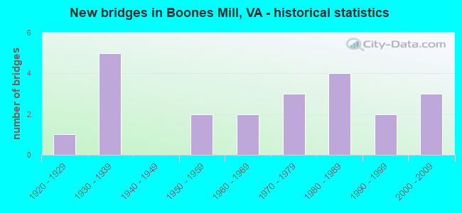
- New bridges - historical statistics
- 11920-1929
- 51930-1939
- 21950-1959
- 21960-1969
- 31970-1979
- 41980-1989
- 21990-1999
- 32000-2009


- Bridge Condition - Deck
- 33.3%Very good
- 52.4%Good
- 14.3%Satisfactory

- Bridge Condition - Superstructure
- 33.3%Very good
- 33.3%Good
- 19.0%Satisfactory
- 14.3%Fair

- Bridge Condition - Substructure
- 9.5%Very good
- 57.1%Good
- 23.8%Satisfactory
- 9.5%Fair

- Bridge Condition - Channel
- 25.0%Very good
- 15.0%Good
- 50.0%Satisfactory
- 10.0%Fair
Find on map >> Show street view
Structure Number: 7775, Location: 1.36RoaCo;0.18-BoonsMill (Lat: 37.125400, Lng: -79.959525), Route carried "on" structure: US 220, Year Built: 1988, Status: Open, Structure Length: 3.13m (10.27ft), Average Daily Traffic: 12,555 (year 2020), Truck Traffic: 13%, Average Future Daily Traffic: 17,577 (year 2040), Design Load: H 15, Features Intersected: Maggodee Creek
Minimum Vertical Clearance: 30+ m (98+ ft), Kilometerpoint: 80.983, Lanes on structure: 2, Base Highway Network: Yes, Owner: State Highway Agency, Approaching Roadway Width: 9.1m (29.9ft), Skew: 4 degrees, Material/Design: Prestressed concrete, Design/Construction: Stringer/Multi-beam, Number Of Spans In Main Unit: 2, Length of Maximum Span: 15.2m (49.9ft), Curb-To-Curb Width: 12.3m (40.4ft), Out-to-Out Width: 13.4m (44.0ft)
Condition: Deck: Good, Superstructure: Good, Substructure: Satisfactory, Channel: Satisfactory, Operating Rating: 68.9 metric tons, Method Used To Determine Operating Rating: Load and Resistance Factor (LRFR), Inventory Rating: 52.6 metric tons, Method Used To Determine Inventory Rating: Load and Resistance Factor (LRFR), Structural Evaluation: Equal to present minimum criteria, Deck Geometry: Better than present minimum criteria, Waterway Adequacy: Better than present minimum criteria, Approach Roadway Alignment: Equal to present desirable criteria, Designated Inspection Frequency: Every 24 months, Inspection Date: July 2020, Deck Structure Type: Concrete Cast-file-Place, Wearing Surface/Protective System: Deck Protection: Epoxy Coated Reinforcing
Find on map >> Show street view
Structure Number: 7779, Location: 1.36 ROA. CO; 0.18 BNS ML (Lat: 37.125419, Lng: -79.959675), Route carried "on" structure: US 220, Year Built: 1952, Status: Open, Structure Length: 2.99m (9.81ft), Average Daily Traffic: 12,555 (year 2020), Truck Traffic: 13%, Average Future Daily Traffic: 17,577 (year 2040), Design Load: HS 15, Features Intersected: MAGGODEE CREEK, Facility Carried by Structure: VIRGIL H. GOODE HY
Minimum Vertical Clearance: 30+ m (98+ ft), Kilometerpoint: 80.984, Lanes on structure: 2, Base Highway Network: Yes, Owner: State Highway Agency, Approaching Roadway Width: 7.3m (24.0ft), Skew: 4 degrees, Material/Design: Concrete, Design/Construction: Tee Beam, Number Of Spans In Main Unit: 2, Length of Maximum Span: 14.2m (46.6ft), Curb or Sidewalk Widths: Left: 0.5m (1.6ft), Right: 0.5m (1.6ft), Curb-To-Curb Width: 8.5m (27.9ft), Out-to-Out Width: 9.0m (29.5ft)
Condition: Deck: Satisfactory, Superstructure: Fair, Substructure: Satisfactory, Channel: Fair, Operating Rating: 40.8 metric tons, Method Used To Determine Operating Rating: Load Factor (LF), Inventory Rating: 23.6 metric tons, Method Used To Determine Inventory Rating: Load Factor (LF), Structural Evaluation: Somewhat better than minimum adequacy, Deck Geometry: High priority of corrective action, Waterway Adequacy: Better than present minimum criteria, Approach Roadway Alignment: Equal to present desirable criteria, Length Of Structure Improvement: 2.99m (9.81ft), Designated Inspection Frequency: Every 24 months, Inspection Date: October 2021, Bridge Improvement Cost: $2,040,000, Roadway Improvement Cost: $714,000, Total Project Cost: $6,835,000 ( Estimate for 2019), Deck Structure Type: Concrete Cast-file-Place, Wearing Surface/Protective System: Wearing Surface: Bituminous
Find on map >> Show street view
Structure Number: 783, Location: 0.30 RT 220; 0.10 RT 614 (Lat: 37.136833, Lng: -79.977178), Route carried "on" structure: County highway 613, Year Built: 1980, Status: Open, Structure Length: 2.23m (7.32ft), Average Daily Traffic: 1,527 (year 2020), Truck Traffic: 3%, Average Future Daily Traffic: 2,129 (year 2040), Design Load: HS 20+Mod, Features Intersected: Maggodee Creek
Minimum Vertical Clearance: 30+ m (98+ ft), Kilometerpoint: 7.461, Lanes on structure: 2, Owner: State Highway Agency, Approaching Roadway Width: 6.7m (22.0ft), Skew: 4 degrees, Material/Design: Prestressed concrete, Design/Construction: Slab, Number Of Spans In Main Unit: 2, Length of Maximum Span: 11.0m (36.1ft), Curb-To-Curb Width: 8.7m (28.5ft), Out-to-Out Width: 9.8m (32.2ft)
Condition: Deck: Satisfactory, Superstructure: Satisfactory, Substructure: Good, Channel: Good, Operating Rating: 89.8 metric tons, Method Used To Determine Operating Rating: Load and Resistance Factor (LRFR), Inventory Rating: 85.3 metric tons, Method Used To Determine Inventory Rating: Load and Resistance Factor (LRFR), Structural Evaluation: Equal to present minimum criteria, Deck Geometry: Somewhat better than minimum adequacy, Waterway Adequacy: Equal to present minimum criteria, Approach Roadway Alignment: Equal to present desirable criteria, Designated Inspection Frequency: Every 24 months, Inspection Date: January 2021, Deck Structure Type: Concrete Precast Panels, Wearing Surface/Protective System: Wearing Surface: Bituminous
Find on map >> Show street view
Structure Number: 7831, Location: 0.40 RT 852; 1.40 RT 726 (Lat: 37.140436, Lng: -79.993906), Route carried "on" structure: County highway 613, Year Built: 1932, Status: Open, Structure Length: 0.98m (3.22ft), Average Daily Traffic: 1,231 (year 2020), Truck Traffic: 3%, Average Future Daily Traffic: 1,723 (year 2040), Design Load: HL 93, Features Intersected: Maggodee Creek
Minimum Vertical Clearance: 30+ m (98+ ft), Kilometerpoint: 5.543, Lanes on structure: 2, Owner: State Highway Agency, Approaching Roadway Width: 5.7m (18.7ft), Skew: 2 degrees, Material/Design: Concrete, Design/Construction: Slab, Number Of Spans In Main Unit: 1, Length of Maximum Span: 8.8m (28.9ft), Curb or Sidewalk Widths: Left: 0.1m (0.3ft), Right: 0.1m (0.3ft), Curb-To-Curb Width: 6.0m (19.7ft), Out-to-Out Width: 6.0m (19.7ft)
Condition: Deck: Very good, Superstructure: Very good, Substructure: Good, Channel: Very good, Operating Rating: 66.2 metric tons, Method Used To Determine Operating Rating: Load and Resistance Factor (LRFR), Inventory Rating: 50.8 metric tons, Method Used To Determine Inventory Rating: Load and Resistance Factor (LRFR), Structural Evaluation: Better than present minimum criteria, Deck Geometry: High priority of replacement, Waterway Adequacy: Somewhat better than minimum adequacy, Approach Roadway Alignment: High priority of corrective action, Length Of Structure Improvement: 0.98m (3.22ft), Designated Inspection Frequency: Every 24 months, Inspection Date: Febuary 2021, Bridge Improvement Cost: $501,000, Roadway Improvement Cost: $125,000, Total Project Cost: $1,604,000 ( Estimate for 2021), Deck Structure Type: Concrete Precast Panels
Find on map >> Show street view
Structure Number: 7832, Location: 1.20 RT 852; 0.60 RT 726 (Lat: 37.143711, Lng: -80.003017), Route carried "on" structure: County highway 613, Year Built: 1932, Status: Open, Structure Length: 0.98m (3.22ft), Average Daily Traffic: 1,231 (year 2020), Truck Traffic: 3%, Average Future Daily Traffic: 1,723 (year 2040), Features Intersected: Maggodee Creek
Minimum Vertical Clearance: 30+ m (98+ ft), Kilometerpoint: 4.254, Lanes on structure: 2, Owner: State Highway Agency, Approaching Roadway Width: 5.5m (18.0ft), Skew: 4 degrees, Material/Design: Steel, Design/Construction: Stringer/Multi-beam, Number Of Spans In Main Unit: 1, Length of Maximum Span: 9.8m (32.2ft), Curb or Sidewalk Widths: Left: 0.2m (0.7ft), Right: 0.2m (0.7ft), Curb-To-Curb Width: 5.8m (19.0ft), Out-to-Out Width: 6.2m (20.3ft)
Condition: Deck: Good, Superstructure: Satisfactory, Substructure: Satisfactory, Channel: Satisfactory, Operating Rating: 49.9 metric tons, Method Used To Determine Operating Rating: Load and Resistance Factor (LRFR), Inventory Rating: 38.1 metric tons, Method Used To Determine Inventory Rating: Load and Resistance Factor (LRFR), Structural Evaluation: Equal to present minimum criteria, Deck Geometry: High priority of replacement, Waterway Adequacy: Somewhat better than minimum adequacy, Approach Roadway Alignment: Equal to present minimum criteria, Length Of Structure Improvement: 0.98m (3.22ft), Designated Inspection Frequency: Every 24 months, Inspection Date: March 2021, Bridge Improvement Cost: $450,000, Roadway Improvement Cost: $68,000, Total Project Cost: $1,328,000 ( Estimate for 2021), Deck Structure Type: Wood or Timber
Find on map >> Show street view
Structure Number: 7896, Location: 0.25 RT 1605;0.25 RT 1612 (Lat: 37.116100, Lng: -79.944900), Route carried "on" structure: County highway 684, Year Built: 1932, Status: Open, Structure Length: 1.56m (5.12ft), Average Daily Traffic: 1,339 (year 2020), Truck Traffic: 3%, Average Future Daily Traffic: 1,473 (year 2040), Design Load: HL 93, Features Intersected: Maggodee Creek
Minimum Vertical Clearance: 30+ m (98+ ft), Kilometerpoint: 0.901, Lanes on structure: 2, Owner: State Highway Agency, Approaching Roadway Width: 6.6m (21.7ft), Skew: 4 degrees, Material/Design: Prestressed concrete, Design/Construction: Slab, Number Of Spans In Main Unit: 1, Length of Maximum Span: 15.6m (51.2ft), Curb-To-Curb Width: 7.1m (23.3ft), Out-to-Out Width: 7.6m (24.9ft)
Condition: Deck: Very good, Superstructure: Very good, Substructure: Good, Channel: Satisfactory, Operating Rating: 54.4 metric tons, Method Used To Determine Operating Rating: Load and Resistance Factor (LRFR), Inventory Rating: 42.6 metric tons, Method Used To Determine Inventory Rating: Load and Resistance Factor (LRFR), Structural Evaluation: Better than present minimum criteria, Deck Geometry: High priority of corrective action, Waterway Adequacy: Meets minimum limits, Approach Roadway Alignment: Meets minimum limits, Length Of Structure Improvement: 1.60m (5.25ft), Designated Inspection Frequency: Every 24 months, Inspection Date: August 2021, Bridge Improvement Cost: $777,000, Roadway Improvement Cost: $116,000, Total Project Cost: $2,291,000 ( Estimate for 2019), Deck Structure Type: Other, Wearing Surface/Protective System: Wearing Surface: Bituminous, Membrane: Other
Find on map >> Show street view
Structure Number: 7898, Location: 0.00 RT 220; 0.01 RT 1603 (Lat: 37.114250, Lng: -79.953150), Route carried "on" structure: County highway 684, Year Built: 1957, Status: Open, Structure Length: 2.01m (6.59ft), Average Daily Traffic: 1,339 (year 2020), Truck Traffic: 2%, Average Future Daily Traffic: 1,473 (year 2040), Design Load: HS 20, Features Intersected: Maggodee Crk.
Minimum Vertical Clearance: 30+ m (98+ ft), Kilometerpoint: 0.016, Lanes on structure: 2, Owner: State Highway Agency, Approaching Roadway Width: 6.1m (20.0ft), Material/Design: Concrete, Design/Construction: Slab, Number Of Spans In Main Unit: 3, Length of Maximum Span: 6.7m (22.0ft), Curb or Sidewalk Widths: Left: 1.5m (4.9ft), Right: 0.5m (1.6ft), Curb-To-Curb Width: 7.3m (24.0ft), Out-to-Out Width: 9.9m (32.5ft)
Condition: Deck: Good, Superstructure: Good, Substructure: Satisfactory, Channel: Good, Operating Rating: 50.8 metric tons, Method Used To Determine Operating Rating: Load and Resistance Factor (LRFR), Inventory Rating: 39.0 metric tons, Method Used To Determine Inventory Rating: Load and Resistance Factor (LRFR), Structural Evaluation: Equal to present minimum criteria, Deck Geometry: Meets minimum limits, Waterway Adequacy: Meets minimum limits, Approach Roadway Alignment: Equal to present desirable criteria, Length Of Structure Improvement: 2.01m (6.59ft), Designated Inspection Frequency: Every 24 months, Inspection Date: July 2020, Bridge Improvement Cost: $1,118,000, Roadway Improvement Cost: $280,000, Total Project Cost: $3,579,000 ( Estimate for 2020), Deck Structure Type: Concrete Cast-file-Place, Wearing Surface/Protective System: Wearing Surface: Epoxy Overlay
Find on map >> Show street view
Structure Number: 7906, Location: 0.50 RT 919; 1.35 RT 220 (Lat: 37.075344, Lng: -79.941836), Route carried "on" structure: County highway 693, Year Built: 1961, Status: Open, Structure Length: 0.96m (3.15ft), Average Daily Traffic: 215 (year 2017), Average Future Daily Traffic: 314 (year 2040), Design Load: HS 20+Mod, Features Intersected: Teels Creek
Minimum Vertical Clearance: 30+ m (98+ ft), Kilometerpoint: 6.619, Lanes on structure: 2, Owner: State Highway Agency, Approaching Roadway Width: 5.5m (18.0ft), Skew: 4 degrees, Material/Design: Steel, Design/Construction: Stringer/Multi-beam, Number Of Spans In Main Unit: 1, Length of Maximum Span: 8.7m (28.5ft), Curb-To-Curb Width: 6.0m (19.7ft), Out-to-Out Width: 6.3m (20.7ft)
Condition: Deck: Good, Superstructure: Very good, Substructure: Good, Channel: Satisfactory, Operating Rating: 52.6 metric tons, Method Used To Determine Operating Rating: Load and Resistance Factor (LRFR), Inventory Rating: 40.8 metric tons, Method Used To Determine Inventory Rating: Load and Resistance Factor (LRFR), Structural Evaluation: Better than present minimum criteria, Deck Geometry: High priority of corrective action, Waterway Adequacy: Somewhat better than minimum adequacy, Approach Roadway Alignment: High priority of corrective action, Length Of Structure Improvement: 0.96m (3.15ft), Designated Inspection Frequency: Every 24 months, Inspection Date: March 2022, Bridge Improvement Cost: $504,000, Roadway Improvement Cost: $126,000, Total Project Cost: $1,613,000 ( Estimate for 2020), Deck Structure Type: Wood or Timber, Wearing Surface/Protective System: Wearing Surface: Bituminous, Membrane: Preformed Fabric
Find on map >> Show street view
Structure Number: 7909, Location: 0.60 RT 710; 0.55 RT 919 (Lat: 37.067514, Lng: -79.926875), Route carried "on" structure: County highway 697, Year Built: 1981, Status: Open, Structure Length: 3.72m (12.20ft), Average Daily Traffic: 966 (year 2017), Average Future Daily Traffic: 1,410 (year 2040), Design Load: HS 20+Mod, Features Intersected: Teel Creek
Minimum Vertical Clearance: 30+ m (98+ ft), Kilometerpoint: 2.634, Lanes on structure: 2, Owner: State Highway Agency, Approaching Roadway Width: 5.8m (19.0ft), Material/Design: Concrete, Design/Construction: Tee Beam, Number Of Spans In Main Unit: 3, Length of Maximum Span: 12.2m (40.0ft), Curb-To-Curb Width: 7.4m (24.3ft), Out-to-Out Width: 8.5m (27.9ft)
Condition: Deck: Good, Superstructure: Good, Substructure: Very good, Channel: Satisfactory, Operating Rating: 82.6 metric tons, Method Used To Determine Operating Rating: Load and Resistance Factor (LRFR), Inventory Rating: 63.5 metric tons, Method Used To Determine Inventory Rating: Load and Resistance Factor (LRFR), Structural Evaluation: Better than present minimum criteria, Deck Geometry: Meets minimum limits, Waterway Adequacy: Better than present minimum criteria, Approach Roadway Alignment: Equal to present minimum criteria, Designated Inspection Frequency: Every 24 months, Inspection Date: April 2021, Deck Structure Type: Concrete Cast-file-Place, Wearing Surface/Protective System: Deck Protection: Other Coated Reinforcing
Find on map >> Show street view
Structure Number: 7912, Location: 0.50 Rt 919; 0.80 Rt 731 (Lat: 37.060636, Lng: -79.941172), Route carried "on" structure: County highway 697, Year Built: 1970, Status: Posted for load, Structure Length: 1.28m (4.20ft), Average Daily Traffic: 700 (year 2017), Average Future Daily Traffic: 780 (year 2040), Design Load: HS 20, Features Intersected: Little Creek
Minimum Vertical Clearance: 30+ m (98+ ft), Kilometerpoint: 1.131, Lanes on structure: 2, Owner: State Highway Agency, Approaching Roadway Width: 5.8m (19.0ft), Skew: 2 degrees, Material/Design: Steel, Design/Construction: Stringer/Multi-beam, Number Of Spans In Main Unit: 1, Length of Maximum Span: 12.8m (42.0ft), Curb or Sidewalk Widths: Left: 0.2m (0.7ft), Right: 0.2m (0.7ft), Curb-To-Curb Width: 7.0m (23.0ft), Out-to-Out Width: 7.6m (24.9ft)
Condition: Deck: Good, Superstructure: Fair, Substructure: Satisfactory, Channel: Satisfactory, Operating Rating: 29.9 metric tons, Method Used To Determine Operating Rating: Load Factor (LF), Inventory Rating: 18.1 metric tons, Method Used To Determine Inventory Rating: Load Factor (LF), Structural Evaluation: Somewhat better than minimum adequacy, Deck Geometry: Meets minimum limits, Waterway Adequacy: Equal to present minimum criteria, Approach Roadway Alignment: Equal to present minimum criteria, Length Of Structure Improvement: 1.28m (4.20ft), Designated Inspection Frequency: Every 12 months, Inspection Date: March 2021, Bridge Improvement Cost: $672,000, Roadway Improvement Cost: $168,000, Total Project Cost: $2,150,000 ( Estimate for 2021), Deck Structure Type: Wood or Timber, Wearing Surface/Protective System: Wearing Surface: Bituminous
Find on map >> Show street view
Structure Number: 794, Location: 0.70 RT 731; 0.60 RT 919 (Lat: 37.066908, Lng: -79.952181), Route carried "on" structure: County highway 735, Year Built: 1961, Status: Open, Structure Length: 1.22m (4.00ft), Average Daily Traffic: 433 (year 2017), Average Future Daily Traffic: 632 (year 2040), Design Load: HL 93, Features Intersected: Little Creek
Minimum Vertical Clearance: 30+ m (98+ ft), Kilometerpoint: 6.859, Lanes on structure: 2, Owner: State Highway Agency, Approaching Roadway Width: 5.5m (18.0ft), Material/Design: Concrete, Design/Construction: Slab, Number Of Spans In Main Unit: 1, Length of Maximum Span: 11.8m (38.7ft), Curb or Sidewalk Widths: Left: 0.1m (0.3ft), Right: 0.1m (0.3ft), Curb-To-Curb Width: 5.9m (19.4ft), Out-to-Out Width: 6.1m (20.0ft)
Condition: Deck: Very good, Superstructure: Very good, Substructure: Good, Channel: Satisfactory, Operating Rating: 59.9 metric tons, Method Used To Determine Operating Rating: Load and Resistance Factor (LRFR), Inventory Rating: 46.3 metric tons, Method Used To Determine Inventory Rating: Load and Resistance Factor (LRFR), Structural Evaluation: Better than present minimum criteria, Deck Geometry: High priority of replacement, Waterway Adequacy: Somewhat better than minimum adequacy, Approach Roadway Alignment: Equal to present minimum criteria, Length Of Structure Improvement: 1.22m (4.00ft), Designated Inspection Frequency: Every 24 months, Inspection Date: March 2021, Bridge Improvement Cost: $543,000, Roadway Improvement Cost: $81,000, Total Project Cost: $1,601,000 ( Estimate for 2019), Deck Structure Type: Concrete Precast Panels, Wearing Surface/Protective System: Deck Protection: Other Coated Reinforcing
Find on map >> Show street view
Structure Number: 8023, Location: 0.40 RT 693; 0.70 RT 691 (Lat: 37.085117, Lng: -79.948408), Route carried "on" structure: County highway 919, Year Built: 1925, Status: Open, Structure Length: 0.99m (3.25ft), Average Daily Traffic: 1,551 (year 2020), Truck Traffic: 4%, Average Future Daily Traffic: 1,899 (year 2040), Design Load: HS 15, Features Intersected: Teels Creek
Minimum Vertical Clearance: 30+ m (98+ ft), Kilometerpoint: 11.746, Lanes on structure: 2, Owner: State Highway Agency, Approaching Roadway Width: 6.7m (22.0ft), Material/Design: Concrete, Design/Construction: Tee Beam, Number Of Spans In Main Unit: 1, Length of Maximum Span: 9.4m (30.8ft), Curb-To-Curb Width: 11.0m (36.1ft), Out-to-Out Width: 11.6m (38.1ft)
Condition: Deck: Satisfactory, Superstructure: Satisfactory, Substructure: Fair, Channel: Fair, Operating Rating: 41.7 metric tons, Method Used To Determine Operating Rating: Load Factor (LF), Inventory Rating: 24.5 metric tons, Method Used To Determine Inventory Rating: Load Factor (LF), Structural Evaluation: Somewhat better than minimum adequacy, Deck Geometry: Equal to present minimum criteria, Waterway Adequacy: Equal to present minimum criteria, Approach Roadway Alignment: Equal to present minimum criteria, Length Of Structure Improvement: 0.99m (3.25ft), Designated Inspection Frequency: Every 24 months, Inspection Date: October 2021, Bridge Improvement Cost: $551,000, Roadway Improvement Cost: $138,000, Total Project Cost: $1,764,000 ( Estimate for 2019), Deck Structure Type: Concrete Cast-file-Place, Wearing Surface/Protective System: Wearing Surface: Bituminous
Find on map >> Show street view
Structure Number: 8026, Location: 0.00 RT 739; 0.22 D. END (Lat: 37.084619, Lng: -79.989956), Route carried "on" structure: County highway 961, Year Built: 1972, Status: Posted for load, Structure Length: 0.77m (2.53ft), Average Daily Traffic: 50 (year 2014), Average Future Daily Traffic: 67 (year 2040), Features Intersected: Little Creek
Minimum Vertical Clearance: 30+ m (98+ ft), Kilometerpoint: 0.428, Lanes on structure: 2, Owner: State Highway Agency, Approaching Roadway Width: 4.3m (14.1ft), Material/Design: Steel, Design/Construction: Stringer/Multi-beam, Number Of Spans In Main Unit: 1, Length of Maximum Span: 7.0m (23.0ft), Curb or Sidewalk Widths: Left: 0.2m (0.7ft), Right: 0.2m (0.7ft), Curb-To-Curb Width: 5.8m (19.0ft), Out-to-Out Width: 6.1m (20.0ft)
Condition: Deck: Good, Superstructure: Satisfactory, Substructure: Good, Channel: Very good, Operating Rating: 21.8 metric tons, Method Used To Determine Operating Rating: Load Factor (LF), Inventory Rating: 12.7 metric tons, Method Used To Determine Inventory Rating: Load Factor (LF), Structural Evaluation: Meets minimum limits, Deck Geometry: Meets minimum limits, Waterway Adequacy: Meets minimum limits, Approach Roadway Alignment: Equal to present desirable criteria, Bridge Posting: Required (Relationship of Operating Rating to Maximum Legal Load: 20.0 - 29.9% below), Length Of Structure Improvement: 0.77m (2.53ft), Designated Inspection Frequency: Every 12 months, Inspection Date: October 2021, Bridge Improvement Cost: $380,000, Roadway Improvement Cost: $95,000, Total Project Cost: $1,234,000 ( Estimate for 2020), Deck Structure Type: Wood or Timber
Find on map >> Show street view
Structure Number: 803, Location: 0.00 RT 1603; 0.01 RT 220 (Lat: 37.114944, Lng: -79.955028), Route carried "on" structure: County highway 1602, Year Built: 1932, Year Reconstructed: 2016, Status: Open, Structure Length: 1.22m (4.00ft), Average Daily Traffic: 1,581 (year 2017), Average Future Daily Traffic: 2,308 (year 2040), Design Load: HL 93, Features Intersected: Maggodee Creek
Minimum Vertical Clearance: 30+ m (98+ ft), Kilometerpoint: 0.069, Lanes on structure: 1, Owner: State Highway Agency, Approaching Roadway Width: 4.6m (15.1ft), Material/Design: Prestressed concrete, Design/Construction: Slab, Number Of Spans In Main Unit: 1, Length of Maximum Span: 12.2m (40.0ft), Curb-To-Curb Width: 3.8m (12.5ft), Out-to-Out Width: 3.8m (12.5ft)
Condition: Deck: Very good, Superstructure: Very good, Substructure: Good, Channel: Very good, Operating Rating: 59.0 metric tons, Method Used To Determine Operating Rating: Load and Resistance Factor (LRFR), Inventory Rating: 45.4 metric tons, Method Used To Determine Inventory Rating: Load and Resistance Factor (LRFR), Structural Evaluation: Better than present minimum criteria, Deck Geometry: High priority of replacement, Waterway Adequacy: Equal to present minimum criteria, Approach Roadway Alignment: Equal to present minimum criteria, Designated Inspection Frequency: Every 24 months, Inspection Date: March 2022, Deck Structure Type: Other, Wearing Surface/Protective System: Wearing Surface: Bituminous, Membrane: Other, Deck Protection: Other Coated Reinforcing
Find on map >> Show street view
Structure Number: 8031, Location: 0.00 RT 684; 0.20 RT 220 (Lat: 37.114481, Lng: -79.948633), Route carried "on" structure: County highway 1605, Year Built: 1986, Status: Posted for load, Structure Length: 1.43m (4.69ft), Average Daily Traffic: 703 (year 2017), Average Future Daily Traffic: 1,026 (year 2040), Features Intersected: Maggodee Creek
Minimum Vertical Clearance: 30+ m (98+ ft), Kilometerpoint: 0.322, Lanes on structure: 2, Owner: State Highway Agency, Approaching Roadway Width: 4.6m (15.1ft), Material/Design: Steel, Design/Construction: Stringer/Multi-beam, Number Of Spans In Main Unit: 1, Length of Maximum Span: 14.3m (46.9ft), Curb or Sidewalk Widths: Left: 0.2m (0.7ft), Right: 0.2m (0.7ft), Curb-To-Curb Width: 7.3m (24.0ft), Out-to-Out Width: 7.7m (25.3ft)
Condition: Deck: Very good, Superstructure: Fair, Substructure: Good, Channel: Very good, Operating Rating: 20.9 metric tons, Method Used To Determine Operating Rating: Load and Resistance Factor (LRFR), Inventory Rating: 16.3 metric tons, Method Used To Determine Inventory Rating: Load and Resistance Factor (LRFR), Structural Evaluation: Meets minimum limits, Deck Geometry: Meets minimum limits, Waterway Adequacy: Meets minimum limits, Approach Roadway Alignment: Equal to present minimum criteria, Length Of Structure Improvement: 1.43m (4.69ft), Designated Inspection Frequency: Every 24 months, Inspection Date: November 2021, Bridge Improvement Cost: $752,000, Roadway Improvement Cost: $188,000, Total Project Cost: $2,444,000 ( Estimate for 2021), Deck Structure Type: Wood or Timber, Wearing Surface/Protective System: Wearing Surface: Bituminous, Membrane: Preformed Fabric
Find on map >> Show street view
Structure Number: 8032, Location: 0.00 RT 220; 0.65 D.END (Lat: 37.120786, Lng: -79.955514), Route carried "on" structure: County highway 1611, Year Built: 1932, Status: Open, Structure Length: 1.55m (5.09ft), Average Daily Traffic: 298 (year 2017), Average Future Daily Traffic: 435 (year 2040), Design Load: HS 20+Mod, Features Intersected: Maggodee Creek
Minimum Vertical Clearance: 30+ m (98+ ft), Kilometerpoint: 0.016, Lanes on structure: 1, Base Highway Network: Yes, Owner: State Highway Agency, Approaching Roadway Width: 2.7m (8.9ft), Material/Design: Steel, Design/Construction: Stringer/Multi-beam, Number Of Spans In Main Unit: 1, Length of Maximum Span: 15.5m (50.9ft), Curb-To-Curb Width: 3.6m (11.8ft), Out-to-Out Width: 4.1m (13.5ft)
Condition: Deck: Good, Superstructure: Very good, Substructure: Fair, Channel: Satisfactory, Operating Rating: 52.6 metric tons, Method Used To Determine Operating Rating: Load and Resistance Factor (LRFR), Inventory Rating: 30.8 metric tons, Method Used To Determine Inventory Rating: Load and Resistance Factor (LRFR), Structural Evaluation: Somewhat better than minimum adequacy, Deck Geometry: High priority of replacement, Waterway Adequacy: Somewhat better than minimum adequacy, Approach Roadway Alignment: Meets minimum limits, Length Of Structure Improvement: 1.55m (5.09ft), Designated Inspection Frequency: Every 24 months, Inspection Date: June 2020, Bridge Improvement Cost: $472,000, Roadway Improvement Cost: $118,000, Total Project Cost: $1,533,000 ( Estimate for 2020), Deck Structure Type: Wood or Timber, Wearing Surface/Protective System: Wearing Surface: Bituminous, Membrane: Preformed Fabric
Find on map >> Show street view
Structure Number: 14932, Location: 7.72-RT419; 0.29-FRANKLC (Lat: 37.142944, Lng: -79.970689), Route carried "on" structure: US 220, Year Built: 1974, Status: Open, Structure Length: 12.26m (40.22ft), Average Daily Traffic: 16,000 (year 2019), Truck Traffic: 13%, Average Future Daily Traffic: 32,000 (year 2039), Design Load: HS 20+Mod, Features Intersected: NS RAILWAY
Minimum Vertical Clearance: 30+ m (98+ ft), Kilometerpoint: 83.626, Lanes on structure: 2, Base Highway Network: Yes, Owner: State Highway Agency, Approaching Roadway Width: 12.2m (40.0ft), Material/Design: Steel continuous, Design/Construction: Stringer/Multi-beam, Number Of Spans In Main Unit: 3, Length of Maximum Span: 51.8m (169.9ft), Curb-To-Curb Width: 11.0m (36.1ft), Out-to-Out Width: 12.2m (40.0ft)
Condition: Deck: Very good, Superstructure: Good, Substructure: Good, Operating Rating: 53.5 metric tons, Method Used To Determine Operating Rating: Load and Resistance Factor (LRFR), Inventory Rating: 40.8 metric tons, Method Used To Determine Inventory Rating: Load and Resistance Factor (LRFR), Structural Evaluation: Better than present minimum criteria, Deck Geometry: Equal to present minimum criteria, Underclear: Better than present minimum criteria, Approach Roadway Alignment: Equal to present desirable criteria, Designated Inspection Frequency: Every 24 months, Inspection Date: Febuary 2022, Deck Structure Type: Concrete Cast-file-Place, Wearing Surface/Protective System: Wearing Surface: Latex Concrete
Find on map >> Show street view
Structure Number: 25441, Location: 0.40 RT 684; 2.00 RT 691 (Lat: 37.110153, Lng: -79.924386), Route carried "on" structure: County highway 692, Year Built: 1999, Status: Open, Structure Length: 1.58m (5.18ft), Average Daily Traffic: 244 (year 2017), Average Future Daily Traffic: 356 (year 2040), Design Load: HL 93, Features Intersected: Maggodee Creek
Minimum Vertical Clearance: 30+ m (98+ ft), Kilometerpoint: 6.742, Lanes on structure: 2, Owner: State Highway Agency, Approaching Roadway Width: 3.7m (12.1ft), Skew: 1 degrees, Material/Design: Concrete continuous, Design/Construction: Slab, Number Of Spans In Main Unit: 2, Length of Maximum Span: 7.9m (25.9ft), Curb-To-Curb Width: 6.3m (20.7ft), Out-to-Out Width: 7.5m (24.6ft)
Condition: Deck: Good, Superstructure: Good, Substructure: Good, Channel: Satisfactory, Operating Rating: 89.8 metric tons, Method Used To Determine Operating Rating: Load and Resistance Factor (LRFR), Inventory Rating: 74.4 metric tons, Method Used To Determine Inventory Rating: Load and Resistance Factor (LRFR), Structural Evaluation: Better than present minimum criteria, Deck Geometry: Meets minimum limits, Waterway Adequacy: Equal to present desirable criteria, Approach Roadway Alignment: Equal to present desirable criteria, Designated Inspection Frequency: Every 24 months, Inspection Date: July 2021, Deck Structure Type: Concrete Cast-file-Place, Wearing Surface/Protective System: Deck Protection: Epoxy Coated Reinforcing
Find on map >> Show street view
Structure Number: 25703, Location: 0.32 MI. FROM FRANKLIN CL (Lat: 37.143486, Lng: -79.970508), Route carried "on" structure: US 220, Year Built: 2000, Status: Open, Structure Length: 11.43m (37.50ft), Average Daily Traffic: 16,000 (year 2019), Truck Traffic: 13%, Average Future Daily Traffic: 32,000 (year 2039), Design Load: HS 20+Mod, Features Intersected: NS RAILWAY
Minimum Vertical Clearance: 30+ m (98+ ft), Kilometerpoint: 83.716, Lanes on structure: 2, Base Highway Network: Yes, Owner: State Highway Agency, Approaching Roadway Width: 7.3m (24.0ft), Material/Design: Steel, Design/Construction: Stringer/Multi-beam, Number Of Spans In Main Unit: 3, Length of Maximum Span: 49.1m (161.1ft), Curb-To-Curb Width: 12.0m (39.4ft), Out-to-Out Width: 13.0m (42.7ft)
Condition: Deck: Good, Superstructure: Good, Substructure: Good, Operating Rating: 71.7 metric tons, Method Used To Determine Operating Rating: Load and Resistance Factor (LRFR), Inventory Rating: 55.3 metric tons, Method Used To Determine Inventory Rating: Load and Resistance Factor (LRFR), Structural Evaluation: Better than present minimum criteria, Deck Geometry: Better than present minimum criteria, Underclear: Superior to present desirable criteria, Approach Roadway Alignment: Equal to present desirable criteria, Designated Inspection Frequency: Every 24 months, Inspection Date: Febuary 2022, Deck Structure Type: Concrete Cast-file-Place, Wearing Surface/Protective System: Deck Protection: Epoxy Coated Reinforcing
Find on map >> Show street view
Structure Number: 27397, Location: 0.00 RT 613; 0.50 End Mnt (Lat: 37.140017, Lng: -79.987650), Route carried "on" structure: County highway 852, Year Built: 2005, Status: Open, Structure Length: 1.22m (4.00ft), Average Daily Traffic: 65 (year 2014), Average Future Daily Traffic: 99 (year 2040), Design Load: HL 93, Features Intersected: Maggodee Creek
Minimum Vertical Clearance: 30+ m (98+ ft), Kilometerpoint: 0.016, Lanes on structure: 2, Owner: State Highway Agency, Approaching Roadway Width: 6.1m (20.0ft), Material/Design: Concrete, Design/Construction: Slab, Number Of Spans In Main Unit: 1, Length of Maximum Span: 11.9m (39.0ft), Curb-To-Curb Width: 6.6m (21.7ft), Out-to-Out Width: 7.7m (25.3ft)
Condition: Deck: Good, Superstructure: Good, Substructure: Very good, Channel: Good, Operating Rating: 84.4 metric tons, Method Used To Determine Operating Rating: Load and Resistance Factor (LRFR), Inventory Rating: 65.3 metric tons, Method Used To Determine Inventory Rating: Load and Resistance Factor (LRFR), Structural Evaluation: Better than present minimum criteria, Deck Geometry: Somewhat better than minimum adequacy, Waterway Adequacy: Somewhat better than minimum adequacy, Approach Roadway Alignment: Equal to present desirable criteria, Designated Inspection Frequency: Every 24 months, Inspection Date: April 2021, Deck Structure Type: Concrete Cast-file-Place, Wearing Surface/Protective System: Deck Protection: Epoxy Coated Reinforcing
Find on map >> Show street view
Structure Number: 2743, Location: 0.25-Rte667N; 0.45-Rte615 (Lat: 37.160131, Lng: -79.973950), Route carried "on" structure: County highway 614, Year Built: 2008, Status: Open, Structure Length: 0.91m (2.99ft), Average Daily Traffic: 184 (year 2018), Average Future Daily Traffic: 247 (year 2040), Design Load: HS 20+Mod, Features Intersected: Branch Back Creek
Minimum Vertical Clearance: 30+ m (98+ ft), Kilometerpoint: 1.899, Lanes on structure: 2, Owner: State Highway Agency, Approaching Roadway Width: 7.9m (25.9ft), Skew: 3 degrees, Material/Design: Prestressed concrete, Design/Construction: Slab, Number Of Spans In Main Unit: 1, Length of Maximum Span: 9.1m (29.9ft), Curb-To-Curb Width: 7.5m (24.6ft), Out-to-Out Width: 8.5m (27.9ft)
Condition: Deck: Very good, Superstructure: Very good, Substructure: Good, Channel: Very good, Operating Rating: 74.4 metric tons, Method Used To Determine Operating Rating: Load and Resistance Factor (LRFR), Inventory Rating: 57.2 metric tons, Method Used To Determine Inventory Rating: Load and Resistance Factor (LRFR), Structural Evaluation: Better than present minimum criteria, Deck Geometry: Somewhat better than minimum adequacy, Waterway Adequacy: Equal to present minimum criteria, Approach Roadway Alignment: Equal to present minimum criteria, Designated Inspection Frequency: Every 24 months, Inspection Date: September 2020, Deck Structure Type: Other, Wearing Surface/Protective System: Wearing Surface: Bituminous
Find on map >> Show street view
Structure Number: 27866, Location: 0.30 RT 684; 2.75 Rke Co (Lat: 37.136558, Lng: -79.916803), Route carried "on" structure: County highway 615, Year Built: 1990, Status: Open, Structure Length: 0.67m (2.20ft), Average Daily Traffic: 77 (year 2017), Average Future Daily Traffic: 86 (year 2040), Design Load: H 20, Features Intersected: WHITE OAK CREEK
Minimum Vertical Clearance: 30+ m (98+ ft), Kilometerpoint: 4.425, Lanes on structure: 2, Owner: State Highway Agency, Approaching Roadway Width: 6.0m (19.7ft), Skew: 3 degrees, Material/Design: Steel, Design/Construction: Culvert, Number Of Spans In Main Unit: 2, Length of Maximum Span: 2.1m (6.9ft)
Condition: Channel: Satisfactory, Culverts: Fair, Operating Rating: 44.5 metric tons, Method Used To Determine Operating Rating: Field evaluation and documented engineering judgment, Inventory Rating: 32.7 metric tons, Method Used To Determine Inventory Rating: Field evaluation and documented engineering judgment, Structural Evaluation: Somewhat better than minimum adequacy, Waterway Adequacy: Equal to present minimum criteria, Approach Roadway Alignment: Equal to present minimum criteria, Designated Inspection Frequency: Every 12 months, Inspection Date: June 2021