Bridge Statistics for Boston Heights, Ohio (OH)
Condition, Traffic, Stress, Structural Evaluation, Project Costs
- National Bridge Inventory (NBI) Statistics
- 28Number of bridges
- 328ft / 100.0mTotal length
- 586,260Total average daily traffic
- 78,744Total average daily truck traffic
- National Bridge Inventory (NBI) Registered Bridges for Boston Heights
- No street view available for this location
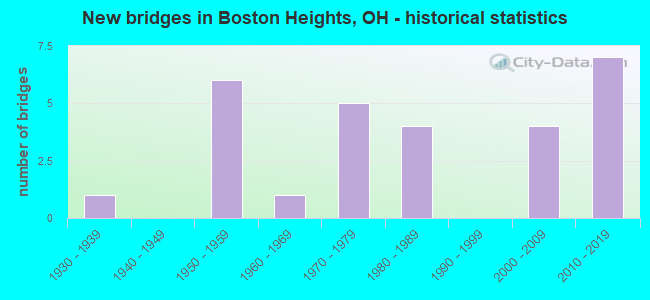
- New bridges - historical statistics
- 11930-1939
- 61950-1959
- 11960-1969
- 51970-1979
- 41980-1989
- 42000-2009
- 72010-2019

- Reconstructed bridges - Historical Statistics
- 11980-1989
- 11990-1999
- 02000-2009
- 22010-2019


- Bridge Condition - Deck
- 40.0%Very good
- 40.0%Good
- 13.3%Satisfactory
- 6.7%Poor

- Bridge Condition - Superstructure
- 6.7%Excellent
- 46.7%Very good
- 40.0%Good
- 6.7%Satisfactory

- Bridge Condition - Substructure
- 20.0%Very good
- 66.7%Good
- 13.3%Fair

- Bridge Condition - Channel
- 50.0%Very good
- 50.0%Good
Find on map >> Show street view
Structure Number: 7700237, Location: 5.96 MI S OF SR 82 (Lat: 41.232161, Lng: -81.490169), Route carried "on" structure: State highway 8, Year Built: 1986, Status: Open, Structure Length: 6.52m (21.39ft), Average Daily Traffic: 40,281 (year 2015), Truck Traffic: 9%, Average Future Daily Traffic: 55,910 (year 2035), Design Load: HS 20+Mod, Features Intersected: OVER SUM-SR 303-10.48
Minimum Vertical Clearance: 30+ m (98+ ft), Kilometerpoint: 20.439, Lanes on structure: 6, Lanes under structure: 4, Base Highway Network: Yes, Owner: State Highway Agency, Approaching Roadway Width: 33.2m (108.9ft), Skew: 31 degrees, Material/Design: Steel continuous, Design/Construction: Stringer/Multi-beam, Number Of Spans In Main Unit: 3, Length of Maximum Span: 28.0m (91.9ft), Curb-To-Curb Width: 32.5m (106.6ft), Out-to-Out Width: 33.5m (109.9ft)
Condition: Deck: Good, Superstructure: Very good, Substructure: Good, Operating Rating: 42.1 metric tons, Method Used To Determine Operating Rating: Load Factor (LF) rating reported by rating factor (RF) method using MS18 loading, Inventory Rating: 32.4 metric tons, Method Used To Determine Inventory Rating: Load Factor (LF) rating reported by rating factor (RF) method using MS18 loading, Structural Evaluation: Better than present minimum criteria, Deck Geometry: Superior to present desirable criteria, Underclear: Equal to present minimum criteria, Approach Roadway Alignment: Equal to present desirable criteria, Designated Inspection Frequency: Every 24 months, Inspection Date: November 2021, Deck Structure Type: Concrete Cast-file-Place, Wearing Surface/Protective System: Wearing Surface: Integral Concrete, Deck Protection: Epoxy Coated Reinforcing
Find on map >> Show street view
Structure Number: 7700253, Location: 5.80 MI S OF SR 82 (Lat: 41.234350, Lng: -81.491600), Route carried "on" structure: State highway 8, Year Built: 1987, Status: Open, Structure Length: 3.87m (12.70ft), Average Daily Traffic: 40,281 (year 2015), Truck Traffic: 9%, Average Future Daily Traffic: 55,910 (year 2035), Design Load: HS 20+Mod, Features Intersected: OVER NB ON RAMP FROM OLD
Minimum Vertical Clearance: 30+ m (98+ ft), Kilometerpoint: 20.712, Lanes on structure: 6, Lanes under structure: 1, Base Highway Network: Yes, Owner: State Highway Agency, Approaching Roadway Width: 34.1m (111.9ft), Skew: 33 degrees, Material/Design: Steel continuous, Design/Construction: Stringer/Multi-beam, Number Of Spans In Main Unit: 3, Length of Maximum Span: 14.3m (46.9ft), Curb-To-Curb Width: 32.5m (106.6ft), Out-to-Out Width: 33.5m (109.9ft)
Condition: Deck: Good, Superstructure: Good, Substructure: Good, Operating Rating: 42.1 metric tons, Method Used To Determine Operating Rating: Load Factor (LF) rating reported by rating factor (RF) method using MS18 loading, Inventory Rating: 32.4 metric tons, Method Used To Determine Inventory Rating: Load Factor (LF) rating reported by rating factor (RF) method using MS18 loading, Structural Evaluation: Better than present minimum criteria, Deck Geometry: Superior to present desirable criteria, Underclear: Meets minimum limits, Approach Roadway Alignment: Equal to present desirable criteria, Designated Inspection Frequency: Every 24 months, Inspection Date: November 2021, Deck Structure Type: Concrete Cast-file-Place, Wearing Surface/Protective System: Wearing Surface: Integral Concrete, Deck Protection: Epoxy Coated Reinforcing
Find on map >> Show street view
Structure Number: 770049, Location: .58 MI N OF SR 303 (Lat: 41.254439, Lng: -81.500000), Route carried "on" structure: County highway C0032, Year Built: 2010, Status: Open, Structure Length: 10.32m (33.86ft), Average Daily Traffic: 3,947 (year 2015), Truck Traffic: 5%, Average Future Daily Traffic: 67,394 (year 2035), Design Load: HS 25 or greater, Features Intersected: OVER SR 8, Facility Carried by Structure: BOSTON MILLS RD
Minimum Vertical Clearance: 30+ m (98+ ft), Kilometerpoint: 12.054, Lanes on structure: 3, Lanes under structure: 8, Owner: State Highway Agency, Approaching Roadway Width: 11.0m (36.1ft), Skew: 2 degrees, Material/Design: Steel continuous, Design/Construction: Stringer/Multi-beam, Number Of Spans In Main Unit: 4, Length of Maximum Span: 29.6m (97.1ft), Curb-To-Curb Width: 17.1m (56.1ft), Out-to-Out Width: 18.0m (59.1ft)
Condition: Deck: Very good, Superstructure: Good, Substructure: Good, Operating Rating: 42.1 metric tons, Method Used To Determine Operating Rating: Load and Resistance Factor Rating (LRFR) rating reported by rating factor(RF) method using HL-93 loadings, Inventory Rating: 32.4 metric tons, Method Used To Determine Inventory Rating: Load and Resistance Factor Rating (LRFR) rating reported by rating factor(RF) method using HL-93 loadings, Structural Evaluation: Better than present minimum criteria, Deck Geometry: Superior to present desirable criteria, Underclear: High priority of corrective action, Approach Roadway Alignment: Equal to present desirable criteria, Designated Inspection Frequency: Every 24 months, Inspection Date: October 2021, Deck Structure Type: Concrete Cast-file-Place, Wearing Surface/Protective System: Wearing Surface: Monolithic Concrete, Deck Protection: Epoxy Coated Reinforcing
Find on map >> Show street view
Structure Number: 7700504, Location: .58 MI N OF SR 303 (Lat: 41.262500, Lng: -81.502500), Route carried "on" structure: County highway C0115, Year Built: 2010, Status: Open, Structure Length: 6.07m (19.91ft), Average Daily Traffic: 1,297 (year 2015), Truck Traffic: 3%, Average Future Daily Traffic: 69,164 (year 2035), Design Load: HS 25 or greater, Features Intersected: OVER SR 8, Facility Carried by Structure: HINES HILL RD
Minimum Vertical Clearance: 30+ m (98+ ft), Kilometerpoint: 0.869, Lanes on structure: 3, Lanes under structure: 5, Owner: State Highway Agency, Approaching Roadway Width: 11.0m (36.1ft), Skew: 2 degrees, Material/Design: Steel continuous, Design/Construction: Stringer/Multi-beam, Number Of Spans In Main Unit: 2, Length of Maximum Span: 29.9m (98.1ft), Curb-To-Curb Width: 15.9m (52.2ft), Out-to-Out Width: 16.8m (55.1ft)
Condition: Deck: Good, Superstructure: Very good, Substructure: Good, Operating Rating: 64.8 metric tons, Method Used To Determine Operating Rating: Load and Resistance Factor Rating (LRFR) rating reported by rating factor(RF) method using HL-93 loadings, Inventory Rating: 48.6 metric tons, Method Used To Determine Inventory Rating: Load and Resistance Factor Rating (LRFR) rating reported by rating factor(RF) method using HL-93 loadings, Structural Evaluation: Better than present minimum criteria, Deck Geometry: Better than present minimum criteria, Underclear: High priority of corrective action, Approach Roadway Alignment: Equal to present desirable criteria, Designated Inspection Frequency: Every 24 months, Inspection Date: October 2021, Deck Structure Type: Concrete Cast-file-Place, Wearing Surface/Protective System: Wearing Surface: Monolithic Concrete, Deck Protection: Epoxy Coated Reinforcing
Find on map >> Show street view
Structure Number: 7700741, Location: 3.25 MI S OF IR 271 (Lat: 41.258100, Lng: -81.504369), Route carried "on" structure: Alternate County highway C7029, Year Built: 2009, Status: Open, Structure Length: 7.60m (24.93ft), Average Daily Traffic: 14,030 (year 2009), Average Future Daily Traffic: 19,474 (year 2029), Design Load: HS 20+Mod, Features Intersected: I80 OH TPK, Facility Carried by Structure: FRONTAGE RD
Minimum Vertical Clearance: 30+ m (98+ ft), Kilometerpoint: 0.467, Lanes on structure: 2, Lanes under structure: 6, Owner: State Highway Agency, Approaching Roadway Width: 15.9m (52.2ft), Material/Design: Prestressed concrete continuous, Design/Construction: Box Beam or Girders - Multiple, Number Of Spans In Main Unit: 4, Length of Maximum Span: 22.1m (72.5ft), Curb-To-Curb Width: 15.9m (52.2ft), Out-to-Out Width: 16.8m (55.1ft)
Condition: Deck: Very good, Superstructure: Very good, Substructure: Good, Operating Rating: 94.0 metric tons, Method Used To Determine Operating Rating: Load Factor (LF) rating reported by rating factor (RF) method using MS18 loading, Inventory Rating: 55.1 metric tons, Method Used To Determine Inventory Rating: Load Factor (LF) rating reported by rating factor (RF) method using MS18 loading, Structural Evaluation: Better than present minimum criteria, Deck Geometry: Superior to present desirable criteria, Underclear: High priority of corrective action, Approach Roadway Alignment: Equal to present desirable criteria, Designated Inspection Frequency: Every 24 months, Inspection Date: October 2021, Deck Structure Type: Concrete Cast-file-Place, Wearing Surface/Protective System: Wearing Surface: Monolithic Concrete, Deck Protection: Epoxy Coated Reinforcing
Find on map >> Show street view
Structure Number: 7709153, Location: 3.13 MI N OF SR 303 (Lat: 41.269931, Lng: -81.543800), Route carried "on" structure: City street M0115, Year Built: 1971, Status: Open, Structure Length: 8.75m (28.71ft), Average Daily Traffic: 301 (year 2015), Truck Traffic: 7%, Average Future Daily Traffic: 41,777 (year 2035), Design Load: H 15, Features Intersected: I-271, Facility Carried by Structure: HINES HILL ROAD
Minimum Vertical Clearance: 30+ m (98+ ft), Kilometerpoint: 1.465, Lanes on structure: 2, Lanes under structure: 4, Owner: State Highway Agency, Approaching Roadway Width: 5.5m (18.0ft), Skew: 1 degrees, Material/Design: Steel continuous, Design/Construction: Stringer/Multi-beam, Number Of Spans In Main Unit: 4, Length of Maximum Span: 25.0m (82.0ft), Curb-To-Curb Width: 8.2m (26.9ft), Out-to-Out Width: 8.5m (27.9ft)
Condition: Deck: Good, Superstructure: Very good, Substructure: Good, Operating Rating: 42.1 metric tons, Method Used To Determine Operating Rating: Load Factor (LF) rating reported by rating factor (RF) method using MS18 loading, Inventory Rating: 32.4 metric tons, Method Used To Determine Inventory Rating: Load Factor (LF) rating reported by rating factor (RF) method using MS18 loading, Structural Evaluation: Better than present minimum criteria, Deck Geometry: Somewhat better than minimum adequacy, Underclear: High priority of corrective action, Approach Roadway Alignment: Equal to present desirable criteria, Designated Inspection Frequency: Every 24 months, Inspection Date: October 2021, Deck Structure Type: Concrete Cast-file-Place, Wearing Surface/Protective System: Wearing Surface: Integral Concrete
Find on map >> Show street view
Structure Number: 7709188, Location: 2.19 MI S OF SR 8 (Lat: 41.275681, Lng: -81.537011), Route carried "on" structure: County highway C0040, Year Built: 1971, Status: Open, Structure Length: 8.02m (26.31ft), Average Daily Traffic: 1,619 (year 2015), Truck Traffic: 5%, Average Future Daily Traffic: 41,777 (year 2035), Design Load: H 15, Features Intersected: I-271, Facility Carried by Structure: BRANDYWINE ROAD
Minimum Vertical Clearance: 30+ m (98+ ft), Kilometerpoint: 0.966, Lanes on structure: 2, Lanes under structure: 4, Owner: State Highway Agency, Approaching Roadway Width: 6.1m (20.0ft), Skew: 1 degrees, Material/Design: Steel continuous, Design/Construction: Stringer/Multi-beam, Number Of Spans In Main Unit: 4, Length of Maximum Span: 24.4m (80.1ft), Curb-To-Curb Width: 8.2m (26.9ft), Out-to-Out Width: 8.5m (27.9ft)
Condition: Deck: Satisfactory, Superstructure: Good, Substructure: Good, Operating Rating: 32.4 metric tons, Method Used To Determine Operating Rating: Load Factor (LF) rating reported by rating factor (RF) method using MS18 loading, Inventory Rating: 25.9 metric tons, Method Used To Determine Inventory Rating: Load Factor (LF) rating reported by rating factor (RF) method using MS18 loading, Structural Evaluation: Equal to present minimum criteria, Deck Geometry: Meets minimum limits, Underclear: High priority of corrective action, Approach Roadway Alignment: Equal to present desirable criteria, Designated Inspection Frequency: Every 12 months, Inspection Date: October 2021, Deck Structure Type: Concrete Cast-file-Place, Wearing Surface/Protective System: Wearing Surface: Integral Concrete
Find on map >> Show street view
Structure Number: 7709994, Location: 0.22 MI W OF SR 8 (Lat: 41.232100, Lng: -81.494761), Route carried "on" structure: State highway 303, Year Built: 1965, Year Reconstructed: 2016, Status: Open, Structure Length: 5.64m (18.50ft), Average Daily Traffic: 9,700 (year 2015), Truck Traffic: 10%, Average Future Daily Traffic: 13,464 (year 2035), Design Load: H 15, Features Intersected: OVER BIKE & HIKE TRAIL
Minimum Vertical Clearance: 30+ m (98+ ft), Kilometerpoint: 16.560, Lanes on structure: 2, Owner: State Highway Agency, Approaching Roadway Width: 7.3m (24.0ft), Skew: 4 degrees, Material/Design: Steel continuous, Design/Construction: Stringer/Multi-beam, Number Of Spans In Main Unit: 3, Length of Maximum Span: 20.1m (65.9ft), Curb-To-Curb Width: 13.1m (43.0ft), Out-to-Out Width: 14.0m (45.9ft)
Condition: Deck: Good, Superstructure: Very good, Substructure: Good, Operating Rating: 74.5 metric tons, Method Used To Determine Operating Rating: Allowable Stress (AS) rating reported by rating factor (RF) method using MS18 loading, Inventory Rating: 71.3 metric tons, Method Used To Determine Inventory Rating: Allowable Stress (AS) rating reported by rating factor (RF) method using MS18 loading, Structural Evaluation: Better than present minimum criteria, Deck Geometry: Somewhat better than minimum adequacy, Approach Roadway Alignment: Better than present minimum criteria, Designated Inspection Frequency: Every 24 months, Inspection Date: October 2021, Deck Structure Type: Concrete Cast-file-Place, Wearing Surface/Protective System: Wearing Surface: Monolithic Concrete, Deck Protection: Epoxy Coated Reinforcing
Find on map >> Show street view
Structure Number: 7729693, Location: 0.8MI WEST OF EXIT 12 (Lat: 41.257819, Lng: -81.509711), Route carried "on" structure: County highway C0016, Year Built: 1954, Year Reconstructed: 1990, Status: Open, Structure Length: 8.78m (28.81ft), Average Daily Traffic: 5,568 (year 2019), Truck Traffic: 4%, Average Future Daily Traffic: 55,210 (year 2039), Design Load: H 15, Features Intersected: I80 OHIO TPK, Facility Carried by Structure: OLDE EIGHT ROAD
Minimum Vertical Clearance: 30+ m (98+ ft), Kilometerpoint: 18.169, Lanes on structure: 2, Lanes under structure: 6, Owner: State Toll Authority, Approaching Roadway Width: 9.1m (29.9ft), Skew: 2 degrees, Material/Design: Steel, Design/Construction: Arch - Deck, Number Of Spans In Main Unit: 1, Length of Maximum Span: 65.8m (215.9ft), Curb-To-Curb Width: 9.1m (29.9ft), Out-to-Out Width: 10.1m (33.1ft)
Condition: Deck: Very good, Superstructure: Good, Substructure: Good, Operating Rating: 51.8 metric tons, Method Used To Determine Operating Rating: Load Factor (LF) rating reported by rating factor (RF) method using MS18 loading, Inventory Rating: 32.4 metric tons, Method Used To Determine Inventory Rating: Load Factor (LF) rating reported by rating factor (RF) method using MS18 loading, Structural Evaluation: Better than present minimum criteria, Deck Geometry: Meets minimum limits, Underclear: High priority of corrective action, Approach Roadway Alignment: Equal to present desirable criteria, Designated Inspection Frequency: Every 12 months, Critical Feature Inspection Frequency: Every 24 months, Inspection Date: July 2021, Critical Feature Inspection Date: July 2021, Deck Structure Type: Concrete Cast-file-Place, Wearing Surface/Protective System: Wearing Surface: Monolithic Concrete, Deck Protection: Epoxy Coated Reinforcing
Find on map >> Show street view
Structure Number: 7729723, Location: 0.3 MILE WEST OF EXIT 12 (Lat: 41.255969, Lng: -81.501169), Route carried "on" structure: Ramp Interstate 80K, Year Built: 2009, Status: Open, Structure Length: 7.89m (25.89ft), Average Daily Traffic: 10,170 (year 2005), Truck Traffic: 8%, Average Future Daily Traffic: 14,116 (year 2025), Design Load: HS 25 or greater, Features Intersected: SR 8, Facility Carried by Structure: TPK EXIT 180 RAMP
Minimum Vertical Clearance: 30+ m (98+ ft), Kilometerpoint: 12.682, Lanes on structure: 2, Lanes under structure: 5, Toll: On toll road, Owner: State Toll Authority, Approaching Roadway Width: 17.5m (57.4ft), Skew: 20 degrees, Material/Design: Steel continuous, Design/Construction: Stringer/Multi-beam, Number Of Spans In Main Unit: 3, Length of Maximum Span: 26.3m (86.3ft), Curb-To-Curb Width: 18.9m (62.0ft), Out-to-Out Width: 20.7m (67.9ft)
Condition: Deck: Very good, Superstructure: Excellent, Substructure: Very good, Operating Rating: 71.3 metric tons, Method Used To Determine Operating Rating: Load Factor (LF) rating reported by rating factor (RF) method using MS18 loading, Inventory Rating: 42.1 metric tons, Method Used To Determine Inventory Rating: Load Factor (LF) rating reported by rating factor (RF) method using MS18 loading, Structural Evaluation: Equal to present desirable criteria, Deck Geometry: Superior to present desirable criteria, Underclear: High priority of corrective action, Approach Roadway Alignment: Equal to present desirable criteria, Designated Inspection Frequency: Every 24 months, Inspection Date: June 2021, Deck Structure Type: Concrete Cast-file-Place, Wearing Surface/Protective System: Wearing Surface: Monolithic Concrete, Deck Protection: Epoxy Coated Reinforcing
Find on map >> Show street view
Structure Number: 7729731, Location: 0.3MI WEST OF EXIT 12 (Lat: 41.258600, Lng: -81.501300), Route carried "on" structure: State highway 8, Year Built: 1954, Year Reconstructed: 2010, Status: Open, Structure Length: 6.37m (20.90ft), Average Daily Traffic: 24,915 (year 2015), Truck Traffic: 10%, Average Future Daily Traffic: 55,210 (year 2035), Design Load: HS 20+Mod, Features Intersected: I80 OHIO TPK
Minimum Vertical Clearance: 30+ m (98+ ft), Kilometerpoint: 23.496, Lanes on structure: 6, Lanes under structure: 6, Base Highway Network: Yes, Owner: State Toll Authority, Approaching Roadway Width: 42.7m (140.1ft), Skew: 31 degrees, Material/Design: Steel continuous, Design/Construction: Stringer/Multi-beam, Number Of Spans In Main Unit: 4, Length of Maximum Span: 20.7m (67.9ft), Curb-To-Curb Width: 42.7m (140.1ft), Out-to-Out Width: 44.5m (146.0ft)
Condition: Deck: Very good, Superstructure: Very good, Substructure: Very good, Operating Rating: 42.1 metric tons, Method Used To Determine Operating Rating: Load Factor (LF) rating reported by rating factor (RF) method using MS18 loading, Inventory Rating: 32.4 metric tons, Method Used To Determine Inventory Rating: Load Factor (LF) rating reported by rating factor (RF) method using MS18 loading, Structural Evaluation: Equal to present desirable criteria, Deck Geometry: Superior to present desirable criteria, Underclear: High priority of corrective action, Approach Roadway Alignment: Equal to present desirable criteria, Designated Inspection Frequency: Every 24 months, Inspection Date: June 2021, Deck Structure Type: Concrete Cast-file-Place, Wearing Surface/Protective System: Wearing Surface: Monolithic Concrete, Deck Protection: Epoxy Coated Reinforcing
Find on map >> Show street view
Structure Number: 7729766, Location: AT EXIT 12 (Lat: 41.258200, Lng: -81.495131), Route carried "on" structure: Ramp Interstate 80K, Year Built: 1954, Year Reconstructed: 1989, Status: Open, Structure Length: 6.49m (21.29ft), Average Daily Traffic: 13,091 (year 2019), Truck Traffic: 8%, Average Future Daily Traffic: 62,218 (year 2039), Design Load: HS 20+Mod, Features Intersected: I80 OH TPK, Facility Carried by Structure: TPK EXIT 12 RAMP
Minimum Vertical Clearance: 30+ m (98+ ft), Kilometerpoint: 13.229, Lanes on structure: 2, Lanes under structure: 7, Toll: On toll road, Owner: State Toll Authority, Approaching Roadway Width: 15.2m (49.9ft), Skew: 20 degrees, Material/Design: Steel continuous, Design/Construction: Stringer/Multi-beam, Number Of Spans In Main Unit: 2, Number Of Approach Spans: 2, Length of Maximum Span: 27.1m (88.9ft), Curb-To-Curb Width: 9.4m (30.8ft), Out-to-Out Width: 10.3m (33.8ft)
Condition: Deck: Satisfactory, Superstructure: Good, Substructure: Good, Operating Rating: 74.5 metric tons, Method Used To Determine Operating Rating: Allowable Stress (AS) rating reported by rating factor (RF) method using MS18 loading, Inventory Rating: 45.4 metric tons, Method Used To Determine Inventory Rating: Allowable Stress (AS) rating reported by rating factor (RF) method using MS18 loading, Structural Evaluation: Better than present minimum criteria, Deck Geometry: Somewhat better than minimum adequacy, Underclear: High priority of corrective action, Approach Roadway Alignment: Equal to present desirable criteria, Designated Inspection Frequency: Every 12 months, Inspection Date: June 2021, Deck Structure Type: Concrete Cast-file-Place, Wearing Surface/Protective System: Wearing Surface: Monolithic Concrete, Deck Protection: Epoxy Coated Reinforcing
Find on map >> Show street view
Structure Number: 7729774, Location: 3.24 MI S OF I-271 (Lat: 41.258311, Lng: -81.501861), Route carried "on" structure: Ramp State highway 8, Year Built: 2010, Status: Open, Structure Length: 6.74m (22.11ft), Average Daily Traffic: 52,020 (year 2010), Truck Traffic: 13%, Average Future Daily Traffic: 4,469 (year 2030), Design Load: HS 20, Features Intersected: I80 OHIO TURNPIKE
Minimum Vertical Clearance: 30+ m (98+ ft), Kilometerpoint: 23.287, Lanes on structure: 1, Lanes under structure: 6, Owner: State Toll Authority, Approaching Roadway Width: 10.1m (33.1ft), Material/Design: Steel continuous, Design/Construction: Stringer/Multi-beam, Number Of Spans In Main Unit: 2, Length of Maximum Span: 36.7m (120.4ft), Curb-To-Curb Width: 10.1m (33.1ft), Out-to-Out Width: 11.0m (36.1ft)
Condition: Deck: Very good, Superstructure: Very good, Substructure: Very good, Operating Rating: 71.3 metric tons, Method Used To Determine Operating Rating: Load Factor (LF) rating reported by rating factor (RF) method using MS18 loading, Inventory Rating: 42.1 metric tons, Method Used To Determine Inventory Rating: Load Factor (LF) rating reported by rating factor (RF) method using MS18 loading, Structural Evaluation: Equal to present desirable criteria, Deck Geometry: Superior to present desirable criteria, Underclear: High priority of corrective action, Approach Roadway Alignment: Equal to present desirable criteria, Designated Inspection Frequency: Every 24 months, Inspection Date: June 2021, Deck Structure Type: Concrete Cast-file-Place, Wearing Surface/Protective System: Wearing Surface: Monolithic Concrete, Deck Protection: Epoxy Coated Reinforcing
Find on map >> Show street view
Structure Number: 7746024, Location: 3000 FT E AKRON-CLEVE RD (Lat: 41.283331, Lng: -81.505000), Route carried "on" structure: County highway C0112, Year Built: 1938, Status: Open, Structure Length: 1.19m (3.90ft), Average Daily Traffic: 8,672 (year 2015), Truck Traffic: 5%, Average Future Daily Traffic: 12,037 (year 2035), Design Load: H 15, Features Intersected: BRANDYWINE CREEK, Facility Carried by Structure: TWINSBURG RD
Minimum Vertical Clearance: 30+ m (98+ ft), Kilometerpoint: 2.816, Lanes on structure: 2, Owner: County Highway Agency, Approaching Roadway Width: 8.8m (28.9ft), Material/Design: Concrete, Design/Construction: Tee Beam, Number Of Spans In Main Unit: 1, Length of Maximum Span: 11.0m (36.1ft), Curb or Sidewalk Widths: Left: 0.6m (2.0ft), Right: 0.6m (2.0ft), Curb-To-Curb Width: 9.1m (29.9ft), Out-to-Out Width: 10.4m (34.1ft)
Condition: Deck: Good, Superstructure: Good, Substructure: Fair, Channel: Good, Operating Rating: 61.6 metric tons, Method Used To Determine Operating Rating: Load Factor (LF) rating reported by rating factor (RF) method using MS18 loading, Inventory Rating: 35.6 metric tons, Method Used To Determine Inventory Rating: Load Factor (LF) rating reported by rating factor (RF) method using MS18 loading, Structural Evaluation: Somewhat better than minimum adequacy, Deck Geometry: High priority of corrective action, Waterway Adequacy: Better than present minimum criteria, Approach Roadway Alignment: Equal to present desirable criteria, Designated Inspection Frequency: Every 12 months, Inspection Date: July 2021, Deck Structure Type: Concrete Cast-file-Place, Wearing Surface/Protective System: Wearing Surface: Bituminous
Find on map >> Show street view
Structure Number: 7746032, Location: 500 FT N OF AKRON-CLEVE (Lat: 41.276481, Lng: -81.537739), Route carried "on" structure: County highway C0040, Year Built: 1970, Status: Open, Structure Length: 4.89m (16.04ft), Average Daily Traffic: 1,619 (year 2015), Truck Traffic: 5%, Average Future Daily Traffic: 2,247 (year 2035), Design Load: HS 20, Features Intersected: BRANDYWINE CREEK, Facility Carried by Structure: BRANDYWINE RD
Minimum Vertical Clearance: 30+ m (98+ ft), Kilometerpoint: 2.527, Lanes on structure: 2, Owner: County Highway Agency, Approaching Roadway Width: 7.3m (24.0ft), Material/Design: Steel continuous, Design/Construction: Stringer/Multi-beam, Number Of Spans In Main Unit: 3, Length of Maximum Span: 18.3m (60.0ft), Curb or Sidewalk Widths: Left: 0.5m (1.6ft), Right: 0.5m (1.6ft), Curb-To-Curb Width: 7.3m (24.0ft), Out-to-Out Width: 8.5m (27.9ft)
Condition: Deck: Poor, Superstructure: Satisfactory, Substructure: Fair, Channel: Very good, Operating Rating: 51.8 metric tons, Method Used To Determine Operating Rating: Load Factor (LF) rating reported by rating factor (RF) method using MS18 loading, Inventory Rating: 32.4 metric tons, Method Used To Determine Inventory Rating: Load Factor (LF) rating reported by rating factor (RF) method using MS18 loading, Structural Evaluation: Somewhat better than minimum adequacy, Deck Geometry: Meets minimum limits, Waterway Adequacy: Superior to present desirable criteria, Approach Roadway Alignment: Equal to present minimum criteria, Designated Inspection Frequency: Every 12 months, Inspection Date: Febuary 2021, Deck Structure Type: Concrete Cast-file-Place, Wearing Surface/Protective System: Wearing Surface: Monolithic Concrete
Find on map >> Show street view
Structure Number: 7768168, Location: 01.0 MI S OF JCT SR303 (Lat: 41.230031, Lng: -81.491519), Route carried "on" structure: County highway C0016, Year Built: 2014, Status: Open, Structure Length: 0.84m (2.76ft), Average Daily Traffic: 4,797 (year 2015), Truck Traffic: 7%, Average Future Daily Traffic: 6,658 (year 2035), Design Load: HL 93, Features Intersected: METRO PARK BIKE PATH, Facility Carried by Structure: AKRON CLEVELAND RD
Minimum Vertical Clearance: 30+ m (98+ ft), Kilometerpoint: 3.138, Lanes on structure: 4, Owner: City or Municipal Highway Agency, Approaching Roadway Width: 14.6m (47.9ft), Skew: 4 degrees, Material/Design: Concrete, Design/Construction: Culvert, Number Of Spans In Main Unit: 1, Length of Maximum Span: 7.4m (24.3ft), Curb or Sidewalk Widths: Left: 0.6m (2.0ft), Right: 0.6m (2.0ft)
Condition: Culverts: Excellent, Operating Rating: 61.6 metric tons, Method Used To Determine Operating Rating: Load and Resistance Factor Rating (LRFR) rating reported by rating factor(RF) method using HL-93 loadings, Inventory Rating: 48.6 metric tons, Method Used To Determine Inventory Rating: Load and Resistance Factor Rating (LRFR) rating reported by rating factor(RF) method using HL-93 loadings, Structural Evaluation: Superior to present desirable criteria, Approach Roadway Alignment: Equal to present desirable criteria, Designated Inspection Frequency: Every 24 months, Inspection Date: April 2021
Find on map >> Show street view
Structure Number: 7700237, Location: 5.96 MI S OF SR 82 (Lat: 41.232161, Lng: -81.490169), Route carried "under" structure: State highway 303, Year Built: 1986, Structure Length: 0. m, Average Daily Traffic: 10,466 (year 2015), Truck Traffic: 6%, Features Intersected: UNDER SR 8, Facility Carried by Structure: SR 8
Minimum Vertical Clearance: 4.52m (14.83ft), Kilometerpoint: 16.866, Lanes on structure: 6, Lanes under structure: 4, Material/Design: Steel continuous, Design/Construction: Stringer/Multi-beam, Length of Maximum Span: 28.0m (91.9ft)
Find on map >> Show street view
Structure Number: 7700253, Location: 5.80 MI S OF SR 82 (Lat: 41.234350, Lng: -81.491600), Route carried "under" structure: Ramp State highway 8, Year Built: 1987, Structure Length: 0. m, Average Daily Traffic: 4,920 (year 1985), Features Intersected: SR 8
Minimum Vertical Clearance: 4.57m (14.99ft), Kilometerpoint: 20.712, Lanes on structure: 6, Lanes under structure: 1, Material/Design: Steel continuous, Design/Construction: Stringer/Multi-beam, Length of Maximum Span: 14.3m (46.9ft)
Find on map >> Show street view
Structure Number: 770049, Location: .58 MI N OF SR 303 (Lat: 41.254439, Lng: -81.500000), Route carried "under" structure: Alternate State highway 8, Year Built: 2010, Structure Length: 0. m, Average Daily Traffic: 48,555 (year 2015), Truck Traffic: 11%, Features Intersected: UNDER BOSTON MILLS RD, Facility Carried by Structure: BOSTON MILLS RD
Minimum Vertical Clearance: 5.11m (16.77ft), Kilometerpoint: 23.110, Lanes on structure: 3, Lanes under structure: 8, Material/Design: Steel continuous, Design/Construction: Stringer/Multi-beam, Length of Maximum Span: 29.6m (97.1ft)
Find on map >> Show street view
Structure Number: 7700504, Location: .58 MI N OF SR 303 (Lat: 41.262500, Lng: -81.502500), Route carried "under" structure: Alternate State highway 8, Year Built: 2010, Structure Length: 0. m, Average Daily Traffic: 49,830 (year 2015), Truck Traffic: 10%, Features Intersected: UNDER HINES HILL RD, Facility Carried by Structure: HINES HILL RD
Minimum Vertical Clearance: 5.44m (17.85ft), Kilometerpoint: 24.028, Lanes on structure: 3, Lanes under structure: 5, Material/Design: Steel continuous, Design/Construction: Stringer/Multi-beam, Length of Maximum Span: 29.9m (98.1ft)
Find on map >> Show street view
Structure Number: 7700741, Location: 3.25 MI S OF IR 271 (Lat: 41.258100, Lng: -81.504369), Route carried "under" structure: Interstate 80K, Year Built: 2009, Structure Length: 0. m, Features Intersected: FRONTAGE RD, Facility Carried by Structure: I80 OH TPK
Minimum Vertical Clearance: 6.33m (20.77ft), Kilometerpoint: 12.489, Lanes on structure: 2, Lanes under structure: 6, Toll: On toll road, Material/Design: Prestressed concrete continuous, Design/Construction: Box Beam or Girders - Multiple, Length of Maximum Span: 22.1m (72.5ft)
Find on map >> Show street view
Structure Number: 7709153, Location: 3.13 MI N OF SR 303 (Lat: 41.269931, Lng: -81.543800), Route carried "under" structure: Interstate 271, Year Built: 1971, Structure Length: 0. m, Average Daily Traffic: 30,099 (year 2015), Truck Traffic: 17%, Features Intersected: UNDER HINES HILL RD TR11, Facility Carried by Structure: HINES HILL ROAD
Minimum Vertical Clearance: 4.98m (16.34ft), Kilometerpoint: 14.693, Lanes on structure: 2, Lanes under structure: 4, Material/Design: Steel continuous, Design/Construction: Stringer/Multi-beam, Length of Maximum Span: 25.0m (82.0ft)
Find on map >> Show street view
Structure Number: 7709188, Location: 2.19 MI S OF SR 8 (Lat: 41.275681, Lng: -81.537011), Route carried "under" structure: Interstate 271, Year Built: 1971, Structure Length: 0. m, Average Daily Traffic: 30,099 (year 2015), Truck Traffic: 17%, Features Intersected: UNDER BRANDYWINE RD CR-4, Facility Carried by Structure: BRANDYWINE ROAD
Minimum Vertical Clearance: 4.98m (16.34ft), Kilometerpoint: 15.562, Lanes on structure: 2, Lanes under structure: 4, Material/Design: Steel continuous, Design/Construction: Stringer/Multi-beam, Length of Maximum Span: 24.4m (80.1ft)
Find on map >> Show street view
Structure Number: 7729693, Location: 0.8MI WEST OF EXIT 12 (Lat: 41.257819, Lng: -81.509711), Route carried "under" structure: Interstate 80K, Year Built: 1954, Structure Length: 0. m, Average Daily Traffic: 43,605 (year 2019), Truck Traffic: 28%, Features Intersected: OLDE EIGHT ROAD, Facility Carried by Structure: I80 OH TPK
Minimum Vertical Clearance: 15.24m (50.00ft), Kilometerpoint: 11.974, Lanes on structure: 2, Lanes under structure: 6, Toll: On toll road, Material/Design: Steel, Design/Construction: Arch - Deck, Length of Maximum Span: 65.8m (215.9ft)
Find on map >> Show street view
Structure Number: 7729723, Location: 0.3 MILE WEST OF EXIT 12 (Lat: 41.255969, Lng: -81.501169), Route carried "under" structure: State highway 8, Year Built: 2009, Structure Length: 0. m, Average Daily Traffic: 48,555 (year 2015), Truck Traffic: 11%, Features Intersected: TPK EXIT 180 RAMP
Minimum Vertical Clearance: 5.08m (16.67ft), Kilometerpoint: 23.287, Lanes on structure: 2, Lanes under structure: 5, Material/Design: Steel continuous, Design/Construction: Stringer/Multi-beam, Length of Maximum Span: 26.3m (86.3ft)
Find on map >> Show street view
Structure Number: 7729731, Location: 0.3MI WEST OF EXIT 12 (Lat: 41.258600, Lng: -81.501300), Route carried "under" structure: Interstate 80K, Year Built: 1954, Structure Length: 0. m, Average Daily Traffic: 39,777 (year 2015), Truck Traffic: 14%, Features Intersected: SR8, Facility Carried by Structure: I80 OH TPK
Minimum Vertical Clearance: 4.78m (15.68ft), Kilometerpoint: 12.714, Lanes on structure: 6, Lanes under structure: 6, Toll: On toll road, Material/Design: Steel continuous, Design/Construction: Stringer/Multi-beam, Length of Maximum Span: 20.7m (67.9ft)
Find on map >> Show street view
Structure Number: 7729766, Location: AT EXIT 12 (Lat: 41.258200, Lng: -81.495131), Route carried "under" structure: Interstate 80K, Year Built: 1954, Structure Length: 0. m, Average Daily Traffic: 44,826 (year 2015), Truck Traffic: 30%, Features Intersected: TPK EXIT 12 RAMP, Facility Carried by Structure: I80 OH TPK
Minimum Vertical Clearance: 4.57m (14.99ft), Kilometerpoint: 13.229, Lanes on structure: 2, Lanes under structure: 7, Toll: On toll road, Material/Design: Steel continuous, Design/Construction: Stringer/Multi-beam, Length of Maximum Span: 27.1m (88.9ft)
Find on map >> Show street view
Structure Number: 7729774, Location: 3.24 MI S OF I-271 (Lat: 41.258311, Lng: -81.501861), Route carried "under" structure: Interstate 80K, Year Built: 2010, Structure Length: 0. m, Average Daily Traffic: 3,220 (year 2005), Truck Traffic: 8%, Features Intersected: SR8 SB TPK RAMP, Facility Carried by Structure: I80 OH TPK
Minimum Vertical Clearance: 4.60m (15.09ft), Kilometerpoint: 12.682, Lanes on structure: 1, Lanes under structure: 6, Toll: On toll road, Material/Design: Steel continuous, Design/Construction: Stringer/Multi-beam, Length of Maximum Span: 36.7m (120.4ft)