Bridge Statistics for Bourbon, Missouri (MO)
Condition, Traffic, Stress, Structural Evaluation, Project Costs
- National Bridge Inventory (NBI) Statistics
- 11Number of bridges
- 92ft / 28.4mTotal length
- $1,438,000Total costs
- 64,230Total average daily traffic
- 19,127Total average daily truck traffic
- National Bridge Inventory (NBI) Registered Bridges for Bourbon
- No street view available for this location
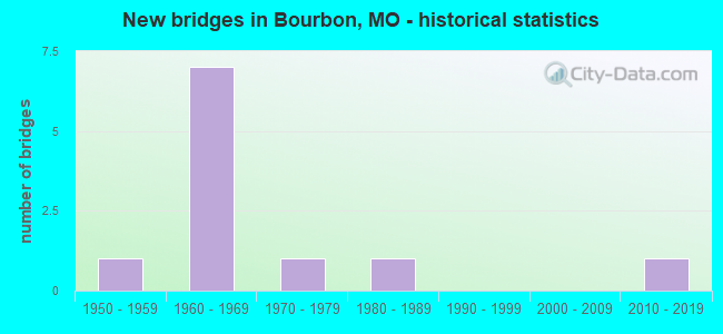
- New bridges - historical statistics
- 11950-1959
- 71960-1969
- 11970-1979
- 11980-1989
- 12010-2019

- Reconstructed bridges - Historical Statistics
- 21970-1979
- 01980-1989
- 11990-1999


- Bridge Condition - Deck
- 40.0%Good
- 20.0%Satisfactory
- 20.0%Fair
- 20.0%Poor

- Bridge Condition - Superstructure
- 20.0%Excellent
- 40.0%Good
- 20.0%Satisfactory
- 20.0%Poor

- Bridge Condition - Substructure
- 20.0%Very good
- 80.0%Satisfactory

- Bridge Condition - Channel
- 20.0%Good
- 60.0%Satisfactory
- 20.0%Fair

- Bridge Condition - Culverts
- 50.0%Satisfactory
- 50.0%Fair
Find on map >> Show street view
Structure Number: 1449, Location: S 34 T 40 N R 3 W (Lat: 38.154181, Lng: -91.251431), Route carried "on" structure: State highway C, Year Built: 1968, Year Reconstructed: 1984, Status: Open, Structure Length: 5.82m (19.09ft), Average Daily Traffic: 2,449 (year 2021), Truck Traffic: 11%, Average Future Daily Traffic: 3,429 (year 2041), Design Load: H 20, Features Intersected: IS 44
Minimum Vertical Clearance: 30+ m (98+ ft), Kilometerpoint: 19.801, Lanes on structure: 2, Lanes under structure: 4, Owner: State Highway Agency, Approaching Roadway Width: 11.6m (38.1ft), Skew: 20 degrees, Material/Design: Concrete continuous, Design/Construction: Slab, Number Of Spans In Main Unit: 4, Length of Maximum Span: 18.3m (60.0ft), Curb-To-Curb Width: 12.2m (40.0ft), Out-to-Out Width: 12.2m (40.0ft)
Condition: Deck: Satisfactory, Superstructure: Good, Substructure: Satisfactory, Operating Rating: 36.9 metric tons, Method Used To Determine Operating Rating: Allowable Stress (AS), Inventory Rating: 21.6 metric tons, Method Used To Determine Inventory Rating: Allowable Stress (AS), Structural Evaluation: Somewhat better than minimum adequacy, Deck Geometry: Equal to present minimum criteria, Underclear: Somewhat better than minimum adequacy, Approach Roadway Alignment: Equal to present desirable criteria, Designated Inspection Frequency: Every 24 months, Inspection Date: September 2020, Deck Structure Type: Concrete Cast-file-Place, Wearing Surface/Protective System: Wearing Surface: Low Slump Concrete, Membrane: Built-up
Find on map >> Show street view
Structure Number: 145, Location: S 35 T 29 N R 24 W (Lat: 37.185464, Lng: -93.527772), Route carried "on" structure: Interstate 44, Year Built: 1960, Year Reconstructed: 1999, Status: Open, Structure Length: 7.01m (23.00ft), Average Daily Traffic: 17,150 (year 2021), Truck Traffic: 26%, Average Future Daily Traffic: 26,583 (year 2041), Design Load: HS 20, Features Intersected: PICKEREL CR
Minimum Vertical Clearance: 30+ m (98+ ft), Kilometerpoint: 368.352, Lanes on structure: 2, Base Highway Network: Yes, Owner: State Highway Agency, Approaching Roadway Width: 12.2m (40.0ft), Material/Design: Concrete, Design/Construction: Tee Beam, Number Of Spans In Main Unit: 4, Length of Maximum Span: 17.5m (57.4ft), Curb-To-Curb Width: 9.4m (30.8ft), Out-to-Out Width: 10.2m (33.5ft)
Condition: Deck: Poor, Superstructure: Poor, Substructure: Satisfactory, Channel: Satisfactory, Operating Rating: 45.9 metric tons, Method Used To Determine Operating Rating: Load Factor (LF), Inventory Rating: 27.9 metric tons, Method Used To Determine Inventory Rating: Load Factor (LF), Structural Evaluation: Meets minimum limits, Deck Geometry: Meets minimum limits, Waterway Adequacy: Equal to present desirable criteria, Approach Roadway Alignment: Equal to present desirable criteria, Length Of Structure Improvement: 0.80m (2.62ft), Designated Inspection Frequency: Every 24 months, Inspection Date: August 2020, Bridge Improvement Cost: $959,000, Roadway Improvement Cost: $96,000, Total Project Cost: $1,438,000 ( Estimate for 2022), Deck Structure Type: Concrete Cast-file-Place, Wearing Surface/Protective System: Wearing Surface: Latex Concrete
Find on map >> Show street view
Structure Number: 145, Location: S 34 T 40 N R 3 W (Lat: 38.158719, Lng: -91.243869), Route carried "on" structure: State highway N, Year Built: 1968, Year Reconstructed: 1984, Status: Open, Structure Length: 6.95m (22.80ft), Average Daily Traffic: 2,511 (year 2021), Truck Traffic: 11%, Average Future Daily Traffic: 3,515 (year 2041), Design Load: H 15, Features Intersected: IS 44
Minimum Vertical Clearance: 30+ m (98+ ft), Kilometerpoint: 0.063, Lanes on structure: 2, Lanes under structure: 4, Owner: State Highway Agency, Approaching Roadway Width: 10.4m (34.1ft), Skew: 23 degrees, Material/Design: Steel continuous, Design/Construction: Stringer/Multi-beam, Number Of Spans In Main Unit: 4, Length of Maximum Span: 21.0m (68.9ft), Curb-To-Curb Width: 10.4m (34.1ft), Out-to-Out Width: 11.2m (36.7ft)
Condition: Deck: Fair, Superstructure: Good, Substructure: Satisfactory, Operating Rating: 39.6 metric tons, Method Used To Determine Operating Rating: Load Factor (LF), Inventory Rating: 23.4 metric tons, Method Used To Determine Inventory Rating: Load Factor (LF), Structural Evaluation: Equal to present minimum criteria, Deck Geometry: Somewhat better than minimum adequacy, Underclear: Equal to present minimum criteria, Approach Roadway Alignment: Equal to present desirable criteria, Designated Inspection Frequency: Every 24 months, Inspection Date: September 2020, Deck Structure Type: Concrete Cast-file-Place, Wearing Surface/Protective System: Wearing Surface: Low Slump Concrete, Membrane: Built-up
Find on map >> Show street view
Structure Number: 1593, Location: S 1 T 39 N R 3 W (Lat: 38.132139, Lng: -91.218147), Route carried "on" structure: State highway N, Year Built: 1978, Status: Open, Structure Length: 1.96m (6.43ft), Average Daily Traffic: 1,137 (year 2021), Truck Traffic: 14%, Average Future Daily Traffic: 1,592 (year 2041), Design Load: H 20, Features Intersected: BLUE SPRINGS CR
Minimum Vertical Clearance: 30+ m (98+ ft), Kilometerpoint: 4.249, Lanes on structure: 2, Owner: State Highway Agency, Approaching Roadway Width: 13.4m (44.0ft), Skew: 5 degrees, Material/Design: Concrete continuous, Design/Construction: Culvert, Number Of Spans In Main Unit: 3, Length of Maximum Span: 4.0m (13.1ft), Curb-To-Curb Width: 15.5m (50.9ft), Out-to-Out Width: 16.1m (52.8ft)
Condition: Channel: Satisfactory, Culverts: Satisfactory, Operating Rating: 69.3 metric tons, Method Used To Determine Operating Rating: Load Factor (LF), Inventory Rating: 41.4 metric tons, Method Used To Determine Inventory Rating: Load Factor (LF), Structural Evaluation: Equal to present minimum criteria, Deck Geometry: Superior to present desirable criteria, Waterway Adequacy: Equal to present desirable criteria, Approach Roadway Alignment: Equal to present desirable criteria, Designated Inspection Frequency: Every 24 months, Inspection Date: September 2020
Find on map >> Show street view
Structure Number: 22882, Location: S 9 T 40 N R 3 W (Lat: 38.215022, Lng: -91.268897), Route carried "on" structure: County highway 378, Year Built: 1989, Status: Open, Structure Length: 2.99m (9.81ft), Average Daily Traffic: 250 (year 2021), Truck Traffic: 18%, Average Future Daily Traffic: 450 (year 2041), Features Intersected: BOONE CR, Facility Carried by Structure: SEMINARY RD
Minimum Vertical Clearance: 30+ m (98+ ft), Kilometerpoint: 2.736, Lanes on structure: 2, Owner: County Highway Agency, Approaching Roadway Width: 6.1m (20.0ft), Material/Design: Prestressed concrete, Design/Construction: Tee Beam, Number Of Spans In Main Unit: 3, Length of Maximum Span: 11.6m (38.1ft), Curb-To-Curb Width: 7.3m (24.0ft), Out-to-Out Width: 8.1m (26.6ft)
Condition: Deck: Good, Superstructure: Satisfactory, Substructure: Satisfactory, Channel: Satisfactory, Operating Rating: 49.5 metric tons, Method Used To Determine Operating Rating: Allowable Stress (AS), Inventory Rating: 32.4 metric tons, Method Used To Determine Inventory Rating: Allowable Stress (AS), Structural Evaluation: Equal to present minimum criteria, Deck Geometry: Somewhat better than minimum adequacy, Waterway Adequacy: Equal to present desirable criteria, Approach Roadway Alignment: Somewhat better than minimum adequacy, Designated Inspection Frequency: Every 24 months, Inspection Date: March 2021, Deck Structure Type: Concrete Cast-file-Place, Wearing Surface/Protective System: Wearing Surface: Monolithic Concrete
Find on map >> Show street view
Structure Number: 33949, Location: S 3 T 39 N R 3 W (Lat: 38.137358, Lng: -91.227989), Route carried "on" structure: State highway N, Year Built: 2012, Status: Open, Structure Length: 2.47m (8.10ft), Average Daily Traffic: 1,137 (year 2021), Truck Traffic: 14%, Average Future Daily Traffic: 1,592 (year 2041), Design Load: HS 20, Features Intersected: BOURBON RVR
Minimum Vertical Clearance: 30+ m (98+ ft), Kilometerpoint: 3.148, Lanes on structure: 2, Owner: State Highway Agency, Approaching Roadway Width: 7.3m (24.0ft), Material/Design: Prestressed concrete, Design/Construction: Box Beam or Girders - Single/Spread, Number Of Spans In Main Unit: 1, Length of Maximum Span: 24.4m (80.1ft), Curb-To-Curb Width: 7.3m (24.0ft), Out-to-Out Width: 7.9m (25.9ft)
Condition: Deck: Good, Superstructure: Excellent, Substructure: Very good, Channel: Good, Operating Rating: 91.8 metric tons, Method Used To Determine Operating Rating: Load Factor (LF), Inventory Rating: 42.3 metric tons, Method Used To Determine Inventory Rating: Load Factor (LF), Structural Evaluation: Equal to present desirable criteria, Deck Geometry: Meets minimum limits, Waterway Adequacy: Superior to present desirable criteria, Approach Roadway Alignment: Equal to present desirable criteria, Designated Inspection Frequency: Every 24 months, Inspection Date: September 2020, Deck Structure Type: Concrete Cast-file-Place, Wearing Surface/Protective System: Wearing Surface: Monolithic Concrete, Deck Protection: Epoxy Coated Reinforcing
Find on map >> Show street view
Structure Number: 7445, Location: S 20 T 40 N R 3 W (Lat: 38.167372, Lng: -91.247017), Route carried "on" structure: State highway J, Year Built: 1950, Status: Posted for load, Structure Length: 1.22m (4.00ft), Average Daily Traffic: 360 (year 2021), Truck Traffic: 8%, Average Future Daily Traffic: 504 (year 2041), Design Load: H 10, Features Intersected: BOONE CR
Minimum Vertical Clearance: 30+ m (98+ ft), Kilometerpoint: 10.441, Lanes on structure: 2, Owner: State Highway Agency, Approaching Roadway Width: 8.5m (27.9ft), Material/Design: Concrete continuous, Design/Construction: Culvert, Number Of Spans In Main Unit: 4, Length of Maximum Span: 3.2m (10.5ft), Curb-To-Curb Width: 7.3m (24.0ft), Out-to-Out Width: 7.9m (25.9ft)
Condition: Channel: Fair, Culverts: Fair, Operating Rating: 23.4 metric tons, Method Used To Determine Operating Rating: Field evaluation and documented engineering judgment, Inventory Rating: 11.7 metric tons, Method Used To Determine Inventory Rating: Field evaluation and documented engineering judgment, Structural Evaluation: Meets minimum limits, Deck Geometry: Somewhat better than minimum adequacy, Waterway Adequacy: Equal to present minimum criteria, Approach Roadway Alignment: Equal to present minimum criteria, Bridge Posting: Required (Relationship of Operating Rating to Maximum Legal Load: 0.1 - 9.9% below), Designated Inspection Frequency: Every 24 months, Inspection Date: September 2020
Find on map >> Show street view
Structure Number: 1449, Location: S 34 T 40 N R 3 W (Lat: 38.154181, Lng: -91.251431), Route carried "under" structure: Interstate 44, Year Built: 1968, Structure Length: 0. m, Average Daily Traffic: 14,747 (year 2021), Truck Traffic: 35%, Features Intersected: IS 44, Facility Carried by Structure: RT C E
Minimum Vertical Clearance: 4.98m (16.34ft), Kilometerpoint: 351.633, Lanes on structure: 2, Lanes under structure: 2, Material/Design: Concrete continuous, Design/Construction: Slab, Length of Maximum Span: 18.3m (60.0ft)
Find on map >> Show street view
Structure Number: 1449, Location: S 34 T 40 N R 3 W (Lat: 38.154181, Lng: -91.251431), Route carried "under" structure: Interstate 44, Year Built: 1968, Structure Length: 0. m, Average Daily Traffic: 8,163 (year 2021), Truck Traffic: 35%, Features Intersected: IS 44, Facility Carried by Structure: RT C E
Minimum Vertical Clearance: 4.95m (16.24ft), Kilometerpoint: 120.136, Lanes on structure: 2, Lanes under structure: 2, Material/Design: Concrete continuous, Design/Construction: Slab, Length of Maximum Span: 18.3m (60.0ft)
Find on map >> Show street view
Structure Number: 145, Location: S 34 T 40 N R 3 W (Lat: 38.158719, Lng: -91.243869), Route carried "under" structure: Interstate 44, Year Built: 1968, Structure Length: 0. m, Average Daily Traffic: 8,163 (year 2021), Truck Traffic: 35%, Features Intersected: IS 44, Facility Carried by Structure: RT N E
Minimum Vertical Clearance: 5.49m (18.01ft), Kilometerpoint: 352.466, Lanes on structure: 2, Lanes under structure: 2, Material/Design: Steel continuous, Design/Construction: Stringer/Multi-beam, Length of Maximum Span: 21.0m (68.9ft)
Find on map >> Show street view
Structure Number: 145, Location: S 34 T 40 N R 3 W (Lat: 38.158719, Lng: -91.243869), Route carried "under" structure: Interstate 44, Year Built: 1968, Structure Length: 0. m, Average Daily Traffic: 8,163 (year 2021), Truck Traffic: 35%, Features Intersected: IS 44, Facility Carried by Structure: RT N E
Minimum Vertical Clearance: 5.33m (17.49ft), Kilometerpoint: 119.286, Lanes on structure: 2, Lanes under structure: 2, Material/Design: Steel continuous, Design/Construction: Stringer/Multi-beam, Length of Maximum Span: 21.0m (68.9ft)