Bridge Statistics for Bowdoinham, Maine (ME)
Condition, Traffic, Stress, Structural Evaluation, Project Costs
- National Bridge Inventory (NBI) Statistics
- 12Number of bridges
- 112ft / 34.5mTotal length
- 45,356Total average daily traffic
- 3,023Total average daily truck traffic
- National Bridge Inventory (NBI) Registered Bridges for Bowdoinham
- No street view available for this location
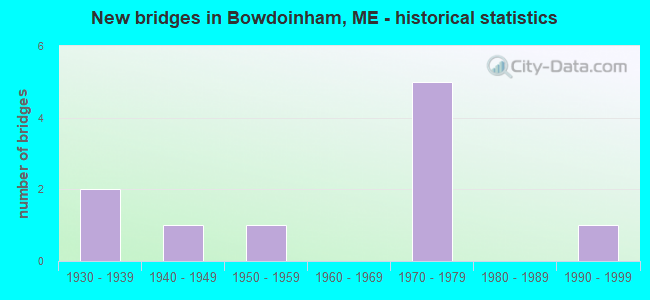
- New bridges - historical statistics
- 21930-1939
- 11940-1949
- 11950-1959
- 51970-1979
- 11990-1999


- Bridge Condition - Deck
- 55.6%Satisfactory
- 44.4%Fair

- Bridge Condition - Superstructure
- 33.3%Good
- 44.4%Satisfactory
- 11.1%Fair
- 11.1%Poor

- Bridge Condition - Substructure
- 11.1%Good
- 44.4%Satisfactory
- 33.3%Fair
- 11.1%Poor

- Bridge Condition - Channel
- 80.0%Satisfactory
- 20.0%Fair
Find on map >> Show street view
Structure Number: 1552, Location: INTERCHANGE 37 (Lat: 44.017231, Lng: -69.920489), Route carried "on" structure: State highway 295, Year Built: 1976, Status: Open, Structure Length: 2.82m (9.25ft), Average Daily Traffic: 12,180 (year 2016), Truck Traffic: 5%, Average Future Daily Traffic: 17,052 (year 2036), Design Load: HS 20+Mod, Features Intersected: ROUTES 125 & 138
Minimum Vertical Clearance: 30+ m (98+ ft), Kilometerpoint: 24.929, Lanes on structure: 2, Lanes under structure: 2, Base Highway Network: Yes, Owner: State Highway Agency, Approaching Roadway Width: 12.5m (41.0ft), Material/Design: Steel, Design/Construction: Stringer/Multi-beam, Number Of Spans In Main Unit: 1, Length of Maximum Span: 26.5m (86.9ft), Curb or Sidewalk Widths: Left: 0.2m (0.7ft), Right: 0.2m (0.7ft), Curb-To-Curb Width: 12.4m (40.7ft), Out-to-Out Width: 14.0m (45.9ft)
Condition: Deck: Satisfactory, Superstructure: Satisfactory, Substructure: Satisfactory, Operating Rating: 73.5 metric tons, Method Used To Determine Operating Rating: Load and Resistance Factor Rating (LRFR) rating reported by rating factor(RF) method using HL-93 loadings, Inventory Rating: 56.7 metric tons, Method Used To Determine Inventory Rating: Load and Resistance Factor Rating (LRFR) rating reported by rating factor(RF) method using HL-93 loadings, Structural Evaluation: Equal to present minimum criteria, Deck Geometry: Better than present minimum criteria, Underclear: Equal to present minimum criteria, Approach Roadway Alignment: Equal to present desirable criteria, Designated Inspection Frequency: Every 24 months, Inspection Date: December 2021, Deck Structure Type: Concrete Cast-file-Place, Wearing Surface/Protective System: Wearing Surface: Latex Concrete
Find on map >> Show street view
Structure Number: 1553, Location: 1.3 MI N OF JCT RTE 138 (Lat: 44.031339, Lng: -69.910819), Route carried "on" structure: City street , Year Built: 1976, Status: Open, Structure Length: 4.31m (14.14ft), Average Daily Traffic: 431 (year 2016), Truck Traffic: 5%, Average Future Daily Traffic: 690 (year 2036), Design Load: HS 20+Mod, Features Intersected: I-295 SOUTHBOUND, Facility Carried by Structure: MILLAY ROAD
Minimum Vertical Clearance: 30+ m (98+ ft), Kilometerpoint: 4.104, Lanes on structure: 2, Lanes under structure: 4, Owner: State Highway Agency, Approaching Roadway Width: 6.1m (20.0ft), Skew: 4 degrees, Material/Design: Steel, Design/Construction: Stringer/Multi-beam, Number Of Spans In Main Unit: 1, Length of Maximum Span: 42.1m (138.1ft), Curb or Sidewalk Widths: Left: 0.2m (0.7ft), Right: 0.2m (0.7ft), Curb-To-Curb Width: 8.5m (27.9ft), Out-to-Out Width: 9.7m (31.8ft)
Condition: Deck: Satisfactory, Superstructure: Good, Substructure: Satisfactory, Operating Rating: 59.0 metric tons, Method Used To Determine Operating Rating: Load and Resistance Factor Rating (LRFR) rating reported by rating factor(RF) method using HL-93 loadings, Inventory Rating: 45.4 metric tons, Method Used To Determine Inventory Rating: Load and Resistance Factor Rating (LRFR) rating reported by rating factor(RF) method using HL-93 loadings, Structural Evaluation: Equal to present minimum criteria, Deck Geometry: Somewhat better than minimum adequacy, Underclear: Superior to present desirable criteria, Approach Roadway Alignment: Equal to present desirable criteria, Designated Inspection Frequency: Every 24 months, Inspection Date: November 2020, Deck Structure Type: Concrete Cast-file-Place, Wearing Surface/Protective System: Wearing Surface: Integral Concrete
Find on map >> Show street view
Structure Number: 2974, Location: 0.3 MI E'LY OF JCT RTE 12 (Lat: 44.009950, Lng: -69.889681), Route carried "on" structure: County highway 24, Year Built: 1934, Status: Open, Structure Length: 0.94m (3.08ft), Average Daily Traffic: 2,243 (year 2016), Truck Traffic: 5%, Average Future Daily Traffic: 3,140 (year 2036), Design Load: H 20, Features Intersected: WEST BR CATHANCE RIVER
Minimum Vertical Clearance: 30+ m (98+ ft), Kilometerpoint: 40.185, Lanes on structure: 2, Owner: State Highway Agency, Approaching Roadway Width: 9.1m (29.9ft), Material/Design: Concrete, Design/Construction: Tee Beam, Number Of Spans In Main Unit: 1, Length of Maximum Span: 9.4m (30.8ft), Curb or Sidewalk Widths: Left: 1.5m (4.9ft), Right: 0.1m (0.3ft), Curb-To-Curb Width: 6.7m (22.0ft), Out-to-Out Width: 8.4m (27.6ft)
Condition: Deck: Satisfactory, Superstructure: Satisfactory, Substructure: Fair, Channel: Satisfactory, Operating Rating: 36.0 metric tons, Method Used To Determine Operating Rating: Load and Resistance Factor Rating (LRFR) rating reported by rating factor(RF) method using HL-93 loadings, Inventory Rating: 27.9 metric tons, Method Used To Determine Inventory Rating: Load and Resistance Factor Rating (LRFR) rating reported by rating factor(RF) method using HL-93 loadings, Structural Evaluation: Somewhat better than minimum adequacy, Deck Geometry: High priority of replacement, Waterway Adequacy: Superior to present desirable criteria, Approach Roadway Alignment: Equal to present desirable criteria, Designated Inspection Frequency: Every 24 months, Underwater Inspection Frequency: Every 60 months, Inspection Date: March 2021, Underwater Inspection Date: August 2019, Deck Structure Type: Concrete Cast-file-Place, Wearing Surface/Protective System: Wearing Surface: Bituminous
Find on map >> Show street view
Structure Number: 3432, Location: 1.7 MI W OF JCT RTE 24 (Lat: 44.010239, Lng: -69.851719), Route carried "on" structure: City street , Year Built: 1949, Status: Posted for load, Structure Length: 2.84m (9.32ft), Average Daily Traffic: 366 (year 2016), Truck Traffic: 5%, Average Future Daily Traffic: 586 (year 2036), Design Load: H 15, Features Intersected: ABAGADASSET RIVER, Facility Carried by Structure: BROWNS POINT ROAD
Minimum Vertical Clearance: 30+ m (98+ ft), Kilometerpoint: 1.336, Lanes on structure: 2, Owner: State Highway Agency, Approaching Roadway Width: 4.9m (16.1ft), Material/Design: Steel, Design/Construction: Girder and Floorbeam System, Number Of Spans In Main Unit: 1, Length of Maximum Span: 27.4m (89.9ft), Curb or Sidewalk Widths: Left: 0.2m (0.7ft), Right: 0.2m (0.7ft), Curb-To-Curb Width: 4.3m (14.1ft), Out-to-Out Width: 4.6m (15.1ft)
Condition: Deck: Fair, Superstructure: Poor, Substructure: Fair, Channel: Satisfactory, Operating Rating: 16.8 metric tons, Method Used To Determine Operating Rating: Load and Resistance Factor Rating (LRFR) rating reported by rating factor(RF) method using HL-93 loadings, Inventory Rating: 13.0 metric tons, Method Used To Determine Inventory Rating: Load and Resistance Factor Rating (LRFR) rating reported by rating factor(RF) method using HL-93 loadings, Structural Evaluation: Meets minimum limits, Deck Geometry: High priority of replacement, Waterway Adequacy: Equal to present minimum criteria, Approach Roadway Alignment: Equal to present minimum criteria, Bridge Posting: Required (Relationship of Operating Rating to Maximum Legal Load: 10.0 - 19.9% below), Designated Inspection Frequency: Every 24 months, Critical Feature Inspection Frequency: Every 24 months, Inspection Date: October 2021, Critical Feature Inspection Date: October 2021, Deck Structure Type: Concrete Cast-file-Place, Wearing Surface/Protective System: Wearing Surface: Bituminous
Find on map >> Show street view
Structure Number: 519, Location: 0.2 MI SB OF JCT RTE 125 (Lat: 44.007139, Lng: -69.895381), Route carried "on" structure: County highway 24, Year Built: 1953, Status: Open, Structure Length: 4.75m (15.58ft), Average Daily Traffic: 1,732 (year 2016), Truck Traffic: 5%, Average Future Daily Traffic: 2,598 (year 2036), Design Load: H 20, Features Intersected: CATHANCE RIVER
Minimum Vertical Clearance: 4.57m (14.99ft), Kilometerpoint: 39.397, Lanes on structure: 2, Owner: State Highway Agency, Approaching Roadway Width: 7.6m (24.9ft), Navigation Control: Yes ( Vertical Clearance: 0.9m (3.0ft), Horizontal Clearance: 8.8m (28.9ft)), Material/Design: Steel, Design/Construction: Truss - Thru, Number Of Spans In Main Unit: 1, Length of Maximum Span: 45.7m (149.9ft), Curb or Sidewalk Widths: Left: 0.3m (1.0ft), Right: 1.5m (4.9ft), Curb-To-Curb Width: 7.4m (24.3ft), Out-to-Out Width: 7.9m (25.9ft)
Condition: Deck: Fair, Superstructure: Fair, Substructure: Fair, Channel: Fair, Operating Rating: 24.9 metric tons, Method Used To Determine Operating Rating: Load and Resistance Factor Rating (LRFR) rating reported by rating factor(RF) method using HL-93 loadings, Inventory Rating: 19.1 metric tons, Method Used To Determine Inventory Rating: Load and Resistance Factor Rating (LRFR) rating reported by rating factor(RF) method using HL-93 loadings, Structural Evaluation: Somewhat better than minimum adequacy, Deck Geometry: Meets minimum limits, Waterway Adequacy: Equal to present desirable criteria, Approach Roadway Alignment: Equal to present desirable criteria, Designated Inspection Frequency: Every 24 months, Critical Feature Inspection Frequency: Every 24 months, Underwater Inspection Frequency: Every 60 months, Inspection Date: August 2021, Critical Feature Inspection Date: August 2021, Underwater Inspection Date: August 2019, Deck Structure Type: Concrete Cast-file-Place, Wearing Surface/Protective System: Wearing Surface: Latex Concrete
Find on map >> Show street view
Structure Number: 5493, Location: 4 MI. NE 138 (Lat: 44.032711, Lng: -69.839861), Route carried "on" structure: County highway 24, Year Built: 1936, Status: Open, Structure Length: 2.29m (7.51ft), Average Daily Traffic: 819 (year 2016), Truck Traffic: 5%, Average Future Daily Traffic: 1,310 (year 2036), Design Load: H 15, Features Intersected: ABAGADASSET RIVER
Minimum Vertical Clearance: 30+ m (98+ ft), Kilometerpoint: 45.223, Lanes on structure: 2, Owner: State Highway Agency, Approaching Roadway Width: 7.9m (25.9ft), Material/Design: Steel, Design/Construction: Stringer/Multi-beam, Number Of Spans In Main Unit: 1, Length of Maximum Span: 21.3m (69.9ft), Curb or Sidewalk Widths: Left: 0.2m (0.7ft), Right: 0.2m (0.7ft), Curb-To-Curb Width: 6.7m (22.0ft), Out-to-Out Width: 7.8m (25.6ft)
Condition: Deck: Fair, Superstructure: Satisfactory, Substructure: Poor, Channel: Satisfactory, Operating Rating: 36.3 metric tons, Method Used To Determine Operating Rating: Load and Resistance Factor Rating (LRFR) rating reported by rating factor(RF) method using HL-93 loadings, Inventory Rating: 27.9 metric tons, Method Used To Determine Inventory Rating: Load and Resistance Factor Rating (LRFR) rating reported by rating factor(RF) method using HL-93 loadings, Structural Evaluation: Meets minimum limits, Deck Geometry: Meets minimum limits, Waterway Adequacy: Superior to present desirable criteria, Approach Roadway Alignment: Equal to present desirable criteria, Designated Inspection Frequency: Every 24 months, Inspection Date: March 2021, Deck Structure Type: Concrete Cast-file-Place, Wearing Surface/Protective System: Wearing Surface: Monolithic Concrete
Find on map >> Show street view
Structure Number: 6311, Location: INTERCHANGE 37 (Lat: 44.017111, Lng: -69.919561), Route carried "on" structure: State highway 295, Year Built: 1976, Year Reconstructed: 2007, Status: Open, Structure Length: 2.82m (9.25ft), Average Daily Traffic: 12,060 (year 2016), Truck Traffic: 5%, Average Future Daily Traffic: 16,884 (year 2036), Design Load: HS 20+Mod, Features Intersected: ROUTES 125 & 138
Minimum Vertical Clearance: 30+ m (98+ ft), Kilometerpoint: 59.755, Lanes on structure: 2, Lanes under structure: 2, Base Highway Network: Yes, Owner: State Highway Agency, Approaching Roadway Width: 12.5m (41.0ft), Material/Design: Steel, Design/Construction: Stringer/Multi-beam, Number Of Spans In Main Unit: 1, Length of Maximum Span: 26.5m (86.9ft), Curb or Sidewalk Widths: Left: 0.2m (0.7ft), Right: 0.2m (0.7ft), Curb-To-Curb Width: 12.4m (40.7ft), Out-to-Out Width: 14.0m (45.9ft)
Condition: Deck: Fair, Superstructure: Satisfactory, Substructure: Satisfactory, Operating Rating: 73.5 metric tons, Method Used To Determine Operating Rating: Load and Resistance Factor Rating (LRFR) rating reported by rating factor(RF) method using HL-93 loadings, Inventory Rating: 56.7 metric tons, Method Used To Determine Inventory Rating: Load and Resistance Factor Rating (LRFR) rating reported by rating factor(RF) method using HL-93 loadings, Structural Evaluation: Equal to present minimum criteria, Deck Geometry: Better than present minimum criteria, Underclear: Equal to present minimum criteria, Approach Roadway Alignment: Equal to present desirable criteria, Designated Inspection Frequency: Every 24 months, Inspection Date: December 2021, Deck Structure Type: Concrete Cast-file-Place, Wearing Surface/Protective System: Wearing Surface: Latex Concrete
Find on map >> Show street view
Structure Number: 6312, Location: 1.2 MI N OF JCT RTE 138 (Lat: 44.030361, Lng: -69.910689), Route carried "on" structure: City street , Year Built: 1976, Status: Open, Structure Length: 4.31m (14.14ft), Average Daily Traffic: 431 (year 2016), Truck Traffic: 5%, Average Future Daily Traffic: 690 (year 2036), Design Load: HS 20+Mod, Features Intersected: I-295 NORTHBOUND, Facility Carried by Structure: MILLAY ROAD
Minimum Vertical Clearance: 30+ m (98+ ft), Kilometerpoint: 4.216, Lanes on structure: 2, Lanes under structure: 4, Owner: State Highway Agency, Approaching Roadway Width: 6.1m (20.0ft), Skew: 4 degrees, Material/Design: Steel, Design/Construction: Stringer/Multi-beam, Number Of Spans In Main Unit: 1, Length of Maximum Span: 42.1m (138.1ft), Curb or Sidewalk Widths: Left: 0.2m (0.7ft), Right: 0.2m (0.7ft), Curb-To-Curb Width: 8.5m (27.9ft), Out-to-Out Width: 9.7m (31.8ft)
Condition: Deck: Satisfactory, Superstructure: Good, Substructure: Good, Operating Rating: 59.0 metric tons, Method Used To Determine Operating Rating: Load and Resistance Factor Rating (LRFR) rating reported by rating factor(RF) method using HL-93 loadings, Inventory Rating: 45.4 metric tons, Method Used To Determine Inventory Rating: Load and Resistance Factor Rating (LRFR) rating reported by rating factor(RF) method using HL-93 loadings, Structural Evaluation: Better than present minimum criteria, Deck Geometry: Somewhat better than minimum adequacy, Underclear: Equal to present minimum criteria, Approach Roadway Alignment: Better than present minimum criteria, Designated Inspection Frequency: Every 24 months, Inspection Date: November 2020, Deck Structure Type: Concrete Cast-file-Place, Wearing Surface/Protective System: Wearing Surface: Integral Concrete
Find on map >> Show street view
Structure Number: 6313, Location: 2.3 MI N JCT MAIN ST (Lat: 44.039450, Lng: -69.900619), Route carried "on" structure: State highway 138, Year Built: 1976, Status: Open, Structure Length: 8.78m (28.81ft), Average Daily Traffic: 853 (year 2016), Truck Traffic: 5%, Average Future Daily Traffic: 1,365 (year 2036), Design Load: HS 20+Mod, Features Intersected: INTERSTATE 295
Minimum Vertical Clearance: 30+ m (98+ ft), Kilometerpoint: 7.323, Lanes on structure: 2, Lanes under structure: 4, Owner: State Highway Agency, Approaching Roadway Width: 9.8m (32.2ft), Skew: 3 degrees, Material/Design: Steel continuous, Design/Construction: Stringer/Multi-beam, Number Of Spans In Main Unit: 2, Length of Maximum Span: 43.0m (141.1ft), Curb or Sidewalk Widths: Left: 0.2m (0.7ft), Right: 0.2m (0.7ft), Curb-To-Curb Width: 8.6m (28.2ft), Out-to-Out Width: 9.7m (31.8ft)
Condition: Deck: Satisfactory, Superstructure: Good, Substructure: Satisfactory, Operating Rating: 48.6 metric tons, Method Used To Determine Operating Rating: Load and Resistance Factor Rating (LRFR) rating reported by rating factor(RF) method using HL-93 loadings, Inventory Rating: 37.3 metric tons, Method Used To Determine Inventory Rating: Load and Resistance Factor Rating (LRFR) rating reported by rating factor(RF) method using HL-93 loadings, Structural Evaluation: Equal to present minimum criteria, Deck Geometry: Somewhat better than minimum adequacy, Underclear: Somewhat better than minimum adequacy, Approach Roadway Alignment: Equal to present desirable criteria, Designated Inspection Frequency: Every 24 months, Inspection Date: March 2021, Deck Structure Type: Concrete Cast-file-Place, Wearing Surface/Protective System: Wearing Surface: Latex Concrete
Find on map >> Show street view
Structure Number: 6366, Location: 2.1 MI. S. RTE. 138 (Lat: 44.074531, Lng: -69.883531), Route carried "on" structure: City street , Year Built: 1991, Status: Posted for load, Structure Length: 0.61m (2.00ft), Average Daily Traffic: 152 (year 2016), Truck Traffic: 5%, Average Future Daily Traffic: 243 (year 2036), Features Intersected: MALLON BK, Facility Carried by Structure: DINGLEY RD (NORTH)
Minimum Vertical Clearance: 30+ m (98+ ft), Kilometerpoint: 0.386, Lanes on structure: 2, Owner: Town or Township Highway Agency, Approaching Roadway Width: 6.1m (20.0ft), Material/Design: Steel, Design/Construction: Culvert, Number Of Spans In Main Unit: 3, Length of Maximum Span: 2.4m (7.9ft)
Condition: Channel: Satisfactory, Culverts: Serious, Operating Rating: 20.0 metric tons, Method Used To Determine Operating Rating: Field evaluation and documented engineering judgment, Inventory Rating: 20.0 metric tons, Method Used To Determine Inventory Rating: Field evaluation and documented engineering judgment, Structural Evaluation: High priority of corrective action, Waterway Adequacy: Somewhat better than minimum adequacy, Approach Roadway Alignment: Better than present minimum criteria, Bridge Posting: Required (Relationship of Operating Rating to Maximum Legal Load: 0.1 - 9.9% below), Designated Inspection Frequency: Every 12 months, Inspection Date: October 2021
Find on map >> Show street view
Location: INTERCHANGE 37 (Lat: 44.017064, Lng: -69.919536), Route carried "under" structure: State highway 12310, Structure Length: 0. m, Average Daily Traffic: 2,829 (year 2014), Truck Traffic: 8%, Features Intersected: I-295 NORTHBOUND, Facility Carried by Structure: ROUTES 125 & 138
Minimum Vertical Clearance: 4.60m (15.09ft), Kilometerpoint: 33.281, Lanes on structure: 2, Length of Maximum Span: 0.0m
Find on map >> Show street view
Location: 1.2 MI N OF JCT RTE 138 (Lat: 44.030336, Lng: -69.910689), Route carried "under" structure: State highway 22310, Structure Length: 0. m, Average Daily Traffic: 11,260 (year 2014), Truck Traffic: 11%, Features Intersected: MILLAY ROAD, Facility Carried by Structure: I-295 NORTHBOUND
Minimum Vertical Clearance: 5.28m (17.32ft), Kilometerpoint: 61.010, Lanes on structure: 2, Length of Maximum Span: 0.0m