Bridge Statistics for Box Elder, South Dakota (SD)
Condition, Traffic, Stress, Structural Evaluation, Project Costs
- National Bridge Inventory (NBI) Statistics
- 38Number of bridges
- 325ft / 99.4mTotal length
- $1,554,000Total costs
- 188,656Total average daily traffic
- 22,062Total average daily truck traffic
- National Bridge Inventory (NBI) Registered Bridges for Box Elder
- No street view available for this location
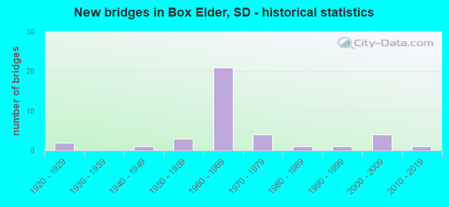
- New bridges - historical statistics
- 21920-1929
- 11940-1949
- 31950-1959
- 211960-1969
- 41970-1979
- 11980-1989
- 11990-1999
- 42000-2009
- 12010-2019
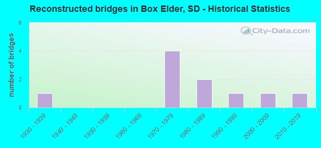
- Reconstructed bridges - Historical Statistics
- 11930-1939
- 01940-1949
- 01950-1959
- 01960-1969
- 41970-1979
- 21980-1989
- 11990-1999
- 12000-2009
- 12010-2019
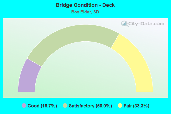
- Bridge Condition - Deck
- 16.7%Good
- 50.0%Satisfactory
- 33.3%Fair
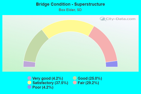
- Bridge Condition - Superstructure
- 4.2%Very good
- 25.0%Good
- 37.5%Satisfactory
- 29.2%Fair
- 4.2%Poor
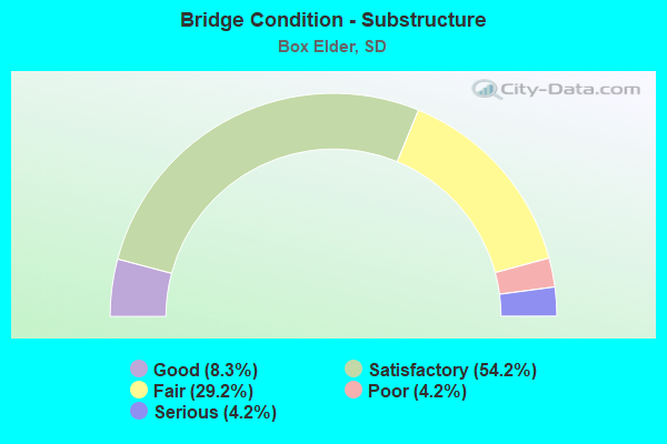
- Bridge Condition - Substructure
- 8.3%Good
- 54.2%Satisfactory
- 29.2%Fair
- 4.2%Poor
- 4.2%Serious
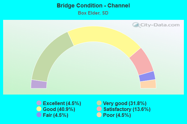
- Bridge Condition - Channel
- 4.5%Excellent
- 31.8%Very good
- 40.9%Good
- 13.6%Satisfactory
- 4.5%Fair
- 4.5%Poor
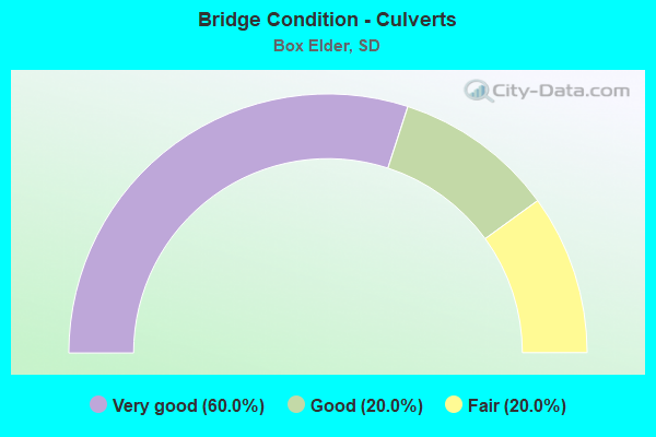
- Bridge Condition - Culverts
- 60.0%Very good
- 20.0%Good
- 20.0%Fair
Find on map >> Show street view
Structure Number: 4724857, Location: 14S&21.8E STURGIS (Lat: 44.212933, Lng: -103.073725), Route carried "on" structure: County highway , Year Built: 1950, Year Reconstructed: 1988, Status: Posted for load, Structure Length: 0.94m (3.08ft), Average Daily Traffic: 10 (year 2019), Truck Traffic: 2%, Average Future Daily Traffic: 10 (year 2032), Design Load: HS 20, Features Intersected: ELK CK, Facility Carried by Structure: HORSESHOE RD.
Minimum Vertical Clearance: 30+ m (98+ ft), Kilometerpoint: 0.000, Lanes on structure: 2, Owner: County Highway Agency, Approaching Roadway Width: 4.9m (16.1ft), Material/Design: Steel, Design/Construction: Stringer/Multi-beam, Number Of Spans In Main Unit: 1, Length of Maximum Span: 8.5m (27.9ft), Curb-To-Curb Width: 6.8m (22.3ft), Out-to-Out Width: 7.4m (24.3ft)
Condition: Deck: Satisfactory, Superstructure: Satisfactory, Substructure: Fair, Channel: Satisfactory, Operating Rating: 30.6 metric tons, Method Used To Determine Operating Rating: Allowable Stress (AS), Inventory Rating: 19.5 metric tons, Method Used To Determine Inventory Rating: Load Factor (LF), Structural Evaluation: Somewhat better than minimum adequacy, Deck Geometry: Somewhat better than minimum adequacy, Waterway Adequacy: Better than present minimum criteria, Approach Roadway Alignment: Equal to present minimum criteria, Bridge Posting: Required (Relationship of Operating Rating to Maximum Legal Load: 10.0 - 19.9% below), Length Of Structure Improvement: 1.83m (6.00ft), Designated Inspection Frequency: Every 24 months, Inspection Date: June 2020, Bridge Improvement Cost: $15,000, Roadway Improvement Cost: $5,000, Total Project Cost: $22,000, Deck Structure Type: Wood or Timber, Wearing Surface/Protective System: Wearing Surface: Wood or Timber
Find on map >> Show street view
Structure Number: 4724957, Location: 14S 21.9E OF STURGIS (Lat: 44.213061, Lng: -103.072647), Route carried "on" structure: County highway , Year Built: 1950, Year Reconstructed: 1994, Status: Posted for load, Structure Length: 2.35m (7.71ft), Average Daily Traffic: 10 (year 2019), Truck Traffic: 2%, Average Future Daily Traffic: 10 (year 2032), Design Load: HS 20, Features Intersected: ELK CK, Facility Carried by Structure: 220TH
Minimum Vertical Clearance: 30+ m (98+ ft), Kilometerpoint: 0.000, Lanes on structure: 2, Owner: County Highway Agency, Approaching Roadway Width: 4.9m (16.1ft), Material/Design: Steel, Design/Construction: Stringer/Multi-beam, Number Of Spans In Main Unit: 3, Length of Maximum Span: 7.6m (24.9ft), Curb-To-Curb Width: 6.5m (21.3ft), Out-to-Out Width: 6.6m (21.7ft)
Condition: Deck: Satisfactory, Superstructure: Satisfactory, Substructure: Satisfactory, Channel: Fair, Operating Rating: 16.6 metric tons, Method Used To Determine Operating Rating: Allowable Stress (AS), Inventory Rating: 12.7 metric tons, Method Used To Determine Inventory Rating: Allowable Stress (AS), Structural Evaluation: Meets minimum limits, Deck Geometry: Somewhat better than minimum adequacy, Waterway Adequacy: Better than present minimum criteria, Approach Roadway Alignment: Equal to present minimum criteria, Bridge Posting: Required (Relationship of Operating Rating to Maximum Legal Load: 30.0 - 39.9% below), Length Of Structure Improvement: 2.29m (7.51ft), Designated Inspection Frequency: Every 24 months, Inspection Date: June 2020, Bridge Improvement Cost: $5,000, Total Project Cost: $10,000, Deck Structure Type: Wood or Timber, Wearing Surface/Protective System: Wearing Surface: Wood or Timber
Find on map >> Show street view
Structure Number: 4725256, Location: 13S&22.2E STURGIS (Lat: 44.227444, Lng: -103.066481), Route carried "on" structure: County highway , Year Built: 1954, Status: Open, Structure Length: 2.26m (7.41ft), Average Daily Traffic: 63 (year 2019), Truck Traffic: 2%, Average Future Daily Traffic: 63 (year 2032), Design Load: HS 20, Features Intersected: ANTELOPE CK, Facility Carried by Structure: ELK CREEK RD.
Minimum Vertical Clearance: 30+ m (98+ ft), Kilometerpoint: 0.000, Lanes on structure: 2, Owner: County Highway Agency, Approaching Roadway Width: 6.1m (20.0ft), Material/Design: Concrete continuous, Design/Construction: Slab, Number Of Spans In Main Unit: 4, Length of Maximum Span: 4.9m (16.1ft), Curb-To-Curb Width: 7.3m (24.0ft), Out-to-Out Width: 8.6m (28.2ft)
Condition: Deck: Good, Superstructure: Good, Substructure: Fair, Channel: Poor, Operating Rating: 32.0 metric tons, Method Used To Determine Operating Rating: Load Factor (LF), Inventory Rating: 19.1 metric tons, Method Used To Determine Inventory Rating: Load Factor (LF), Structural Evaluation: Somewhat better than minimum adequacy, Deck Geometry: Equal to present minimum criteria, Waterway Adequacy: Better than present minimum criteria, Approach Roadway Alignment: Equal to present desirable criteria, Length Of Structure Improvement: 2.87m (9.42ft), Designated Inspection Frequency: Every 24 months, Inspection Date: June 2020, Bridge Improvement Cost: $15,000, Roadway Improvement Cost: $5,000, Total Project Cost: $20,000, Deck Structure Type: Concrete Cast-file-Place, Wearing Surface/Protective System: Wearing Surface: Monolithic Concrete
Find on map >> Show street view
Structure Number: 47270568, Location: 24E & 13.8S STURGIS (Lat: 44.214275, Lng: -103.030417), Route carried "on" structure: County highway , Year Built: 1976, Status: Open, Structure Length: 1.52m (4.99ft), Average Daily Traffic: 56 (year 2019), Truck Traffic: 2%, Average Future Daily Traffic: 56 (year 2032), Design Load: HS 20, Features Intersected: ANTELOPE CK, Facility Carried by Structure: ANTELOPE CREEK RD
Minimum Vertical Clearance: 30+ m (98+ ft), Kilometerpoint: 0.000, Lanes on structure: 2, Owner: County Highway Agency, Approaching Roadway Width: 7.3m (24.0ft), Material/Design: Prestressed concrete, Design/Construction: Tee Beam, Number Of Spans In Main Unit: 1, Length of Maximum Span: 14.3m (46.9ft), Curb-To-Curb Width: 8.2m (26.9ft), Out-to-Out Width: 8.2m (26.9ft)
Condition: Deck: Satisfactory, Superstructure: Good, Substructure: Satisfactory, Channel: Good, Operating Rating: 32.7 metric tons, Method Used To Determine Operating Rating: Field evaluation and documented engineering judgment, Inventory Rating: 24.5 metric tons, Method Used To Determine Inventory Rating: Field evaluation and documented engineering judgment, Structural Evaluation: Equal to present minimum criteria, Deck Geometry: Equal to present minimum criteria, Waterway Adequacy: Equal to present desirable criteria, Approach Roadway Alignment: Better than present minimum criteria, Designated Inspection Frequency: Every 24 months, Inspection Date: June 2020, Bridge Improvement Cost: $3,000, Roadway Improvement Cost: $5,000, Total Project Cost: $8,000, Deck Structure Type: Concrete Precast Panels, Wearing Surface/Protective System: Wearing Surface: Monolithic Concrete
Find on map >> Show street view
Structure Number: 47270575, Location: 24E & 13.5S STURGIS (Lat: 44.205414, Lng: -103.030403), Route carried "on" structure: County highway , Year Built: 1976, Status: Open, Structure Length: 2.44m (8.01ft), Average Daily Traffic: 56 (year 2019), Truck Traffic: 2%, Average Future Daily Traffic: 56 (year 2032), Design Load: HS 20, Features Intersected: ELK CK, Facility Carried by Structure: ANTELOPE CREEK RD.
Minimum Vertical Clearance: 30+ m (98+ ft), Kilometerpoint: 0.000, Lanes on structure: 2, Owner: County Highway Agency, Approaching Roadway Width: 7.3m (24.0ft), Material/Design: Prestressed concrete, Design/Construction: Tee Beam, Number Of Spans In Main Unit: 2, Length of Maximum Span: 11.6m (38.1ft), Curb-To-Curb Width: 8.2m (26.9ft), Out-to-Out Width: 8.2m (26.9ft)
Condition: Deck: Good, Superstructure: Good, Substructure: Poor, Channel: Satisfactory, Operating Rating: 32.7 metric tons, Method Used To Determine Operating Rating: Field evaluation and documented engineering judgment, Inventory Rating: 24.5 metric tons, Method Used To Determine Inventory Rating: Field evaluation and documented engineering judgment, Structural Evaluation: Meets minimum limits, Deck Geometry: Equal to present minimum criteria, Waterway Adequacy: Equal to present minimum criteria, Approach Roadway Alignment: Equal to present desirable criteria, Length Of Structure Improvement: 2.80m (9.19ft), Designated Inspection Frequency: Every 24 months, Inspection Date: June 2020, Bridge Improvement Cost: $20,000, Roadway Improvement Cost: $15,000, Total Project Cost: $40,000, Deck Structure Type: Concrete Precast Panels, Wearing Surface/Protective System: Wearing Surface: Integral Concrete
Find on map >> Show street view
Structure Number: 5246028, Location: .5N1E STPAT EXIT BOXELDER (Lat: 44.108772, Lng: -103.131089), Route carried "on" structure: County highway , Year Built: 1973, Status: Posted for load, Structure Length: 1.22m (4.00ft), Average Daily Traffic: 96 (year 2019), Truck Traffic: 2%, Average Future Daily Traffic: 96 (year 2032), Design Load: HS 20, Features Intersected: BOXELDER CK, Facility Carried by Structure: BENNET ROAD
Minimum Vertical Clearance: 30+ m (98+ ft), Kilometerpoint: 0.000, Lanes on structure: 2, Owner: Town or Township Highway Agency, Approaching Roadway Width: 7.3m (24.0ft), Material/Design: Prestressed concrete, Design/Construction: Tee Beam, Number Of Spans In Main Unit: 1, Length of Maximum Span: 11.9m (39.0ft), Curb-To-Curb Width: 8.0m (26.2ft), Out-to-Out Width: 8.2m (26.9ft)
Condition: Deck: Fair, Superstructure: Poor, Substructure: Serious, Channel: Good, Operating Rating: 16.3 metric tons, Method Used To Determine Operating Rating: Field evaluation and documented engineering judgment, Inventory Rating: 12.2 metric tons, Method Used To Determine Inventory Rating: Field evaluation and documented engineering judgment, Structural Evaluation: High priority of corrective action, Deck Geometry: Equal to present minimum criteria, Waterway Adequacy: Equal to present minimum criteria, Approach Roadway Alignment: Equal to present minimum criteria, Bridge Posting: Required (Relationship of Operating Rating to Maximum Legal Load: > 39.9% below), Designated Inspection Frequency: Every 12 months, Inspection Date: June 2021, Deck Structure Type: Concrete Precast Panels, Wearing Surface/Protective System: Wearing Surface: Monolithic Concrete
Find on map >> Show street view
Structure Number: 52467275, Location: 2.1 E ELK VALE RD - BOX E (Lat: 44.116775, Lng: -103.115564), Route carried "on" structure: County highway , Year Built: 1963, Status: Open, Structure Length: 0.62m (2.03ft), Average Daily Traffic: 50 (year 2019), Truck Traffic: 5%, Average Future Daily Traffic: 50 (year 2032), Design Load: HS 20, Features Intersected: CK, Facility Carried by Structure: OFFETT ST
Minimum Vertical Clearance: 30+ m (98+ ft), Kilometerpoint: 0.000, Lanes on structure: 2, Owner: Town or Township Highway Agency, Approaching Roadway Width: 9.8m (32.2ft), Material/Design: Concrete continuous, Design/Construction: Culvert, Number Of Spans In Main Unit: 2, Length of Maximum Span: 3.0m (9.8ft)
Condition: Channel: Satisfactory, Culverts: Fair, Operating Rating: 89.8 metric tons, Method Used To Determine Operating Rating: Load Factor (LF), Inventory Rating: 89.8 metric tons, Method Used To Determine Inventory Rating: Load Factor (LF), Structural Evaluation: Somewhat better than minimum adequacy, Waterway Adequacy: Equal to present desirable criteria, Approach Roadway Alignment: Equal to present desirable criteria, Length Of Structure Improvement: 0.64m (2.10ft), Designated Inspection Frequency: Every 48 months, Inspection Date: September 2019, Bridge Improvement Cost: $12,000, Roadway Improvement Cost: $1,000, Total Project Cost: $14,000
Find on map >> Show street view
Structure Number: 52467276, Location: 2.0 E US 16 B INTERCHANGE (Lat: 44.115286, Lng: -103.116361), Route carried "on" structure: Ramp Interstate 90, Year Built: 1963, Status: Open, Structure Length: 10.80m (35.43ft), Average Daily Traffic: 7,170 (year 2020), Truck Traffic: 10%, Average Future Daily Traffic: 9,256 (year 2040), Design Load: HS 20, Features Intersected: I090
Minimum Vertical Clearance: 30+ m (98+ ft), Kilometerpoint: 101.550, Lanes on structure: 2, Lanes under structure: 4, Base Highway Network: Yes, Owner: State Highway Agency, Approaching Roadway Width: 9.8m (32.2ft), Skew: 5 degrees, Material/Design: Steel continuous, Design/Construction: Stringer/Multi-beam, Number Of Spans In Main Unit: 4, Length of Maximum Span: 32.6m (107.0ft), Curb-To-Curb Width: 9.1m (29.9ft), Out-to-Out Width: 9.8m (32.2ft)
Condition: Deck: Fair, Superstructure: Fair, Substructure: Satisfactory, Operating Rating: 40.2 metric tons, Method Used To Determine Operating Rating: Load Factor (LF), Inventory Rating: 24.0 metric tons, Method Used To Determine Inventory Rating: Load Factor (LF), Structural Evaluation: Somewhat better than minimum adequacy, Deck Geometry: Meets minimum limits, Underclear: Equal to present minimum criteria, Approach Roadway Alignment: Equal to present minimum criteria, Designated Inspection Frequency: Every 24 months, Inspection Date: Febuary 2022, Deck Structure Type: Concrete Cast-file-Place, Wearing Surface/Protective System: Wearing Surface: Epoxy Overlay, Membrane: Epoxy
Find on map >> Show street view
Structure Number: 52469275, Location: 2.1 E US 16 B INTERCHANGE (Lat: 44.116397, Lng: -103.115161), Route carried "on" structure: Interstate 90, Year Built: 1962, Status: Open, Structure Length: 2.53m (8.30ft), Average Daily Traffic: 9,670 (year 2021), Truck Traffic: 15%, Average Future Daily Traffic: 14,012 (year 2041), Design Load: HS 20+Mod, Features Intersected: CK
Minimum Vertical Clearance: 30+ m (98+ ft), Kilometerpoint: 102.934, Lanes on structure: 2, Base Highway Network: Yes, Owner: State Highway Agency, Approaching Roadway Width: 11.6m (38.1ft), Material/Design: Concrete continuous, Design/Construction: Slab, Number Of Spans In Main Unit: 3, Length of Maximum Span: 8.8m (28.9ft), Curb-To-Curb Width: 11.6m (38.1ft), Out-to-Out Width: 12.9m (42.3ft)
Condition: Deck: Satisfactory, Superstructure: Satisfactory, Substructure: Satisfactory, Channel: Very good, Operating Rating: 54.2 metric tons, Method Used To Determine Operating Rating: Load Factor (LF), Inventory Rating: 32.5 metric tons, Method Used To Determine Inventory Rating: Load Factor (LF), Structural Evaluation: Equal to present minimum criteria, Deck Geometry: Equal to present minimum criteria, Waterway Adequacy: Equal to present desirable criteria, Approach Roadway Alignment: Equal to present desirable criteria, Designated Inspection Frequency: Every 24 months, Inspection Date: December 2020, Deck Structure Type: Concrete Cast-file-Place, Wearing Surface/Protective System: Wearing Surface: Epoxy Overlay, Membrane: Epoxy
Find on map >> Show street view
Structure Number: 52469277, Location: 2.9 W OF BOX ELDER (Lat: 44.115250, Lng: -103.114358), Route carried "on" structure: Ramp Interstate 90, Year Built: 1962, Status: Posted for load, Structure Length: 4.60m (15.09ft), Average Daily Traffic: 7,170 (year 2020), Truck Traffic: 10%, Average Future Daily Traffic: 9,256 (year 2040), Design Load: HS 20, Features Intersected: CHANNEL CK
Minimum Vertical Clearance: 30+ m (98+ ft), Kilometerpoint: 101.292, Lanes on structure: 2, Base Highway Network: Yes, Owner: State Highway Agency, Approaching Roadway Width: 9.8m (32.2ft), Material/Design: Steel, Design/Construction: Stringer/Multi-beam, Number Of Spans In Main Unit: 3, Length of Maximum Span: 16.0m (52.5ft), Curb-To-Curb Width: 9.1m (29.9ft), Out-to-Out Width: 9.8m (32.2ft)
Condition: Deck: Satisfactory, Superstructure: Satisfactory, Substructure: Fair, Channel: Very good, Operating Rating: 40.7 metric tons, Method Used To Determine Operating Rating: Load Factor (LF), Inventory Rating: 24.4 metric tons, Method Used To Determine Inventory Rating: Load Factor (LF), Structural Evaluation: Somewhat better than minimum adequacy, Deck Geometry: Meets minimum limits, Waterway Adequacy: Superior to present desirable criteria, Approach Roadway Alignment: Better than present minimum criteria, Designated Inspection Frequency: Every 24 months, Inspection Date: Febuary 2022, Deck Structure Type: Concrete Cast-file-Place, Wearing Surface/Protective System: Wearing Surface: Epoxy Overlay, Membrane: Epoxy
Find on map >> Show street view
Structure Number: 52469278, Location: 2.7 W OF BOX ELDER (Lat: 44.114647, Lng: -103.111267), Route carried "on" structure: Ramp Interstate 90, Year Built: 1994, Status: Open, Structure Length: 1.52m (4.99ft), Design Load: HS 20+Mod, Features Intersected: CHANNEL CK
Minimum Vertical Clearance: 30+ m (98+ ft), Kilometerpoint: 103.191, Lanes on structure: 2, Base Highway Network: Yes, Owner: State Highway Agency, Approaching Roadway Width: 9.1m (29.9ft), Material/Design: Concrete continuous, Design/Construction: Culvert, Number Of Spans In Main Unit: 4, Length of Maximum Span: 3.7m (12.1ft)
Condition: Channel: Good, Culverts: Good, Operating Rating: 98.3 metric tons, Method Used To Determine Operating Rating: Load Factor (LF), Inventory Rating: 58.9 metric tons, Method Used To Determine Inventory Rating: Load Factor (LF), Structural Evaluation: Better than present minimum criteria, Waterway Adequacy: Equal to present desirable criteria, Approach Roadway Alignment: Equal to present desirable criteria, Designated Inspection Frequency: Every 48 months, Inspection Date: Febuary 2019
Find on map >> Show street view
Structure Number: 52480282, Location: 1.0W 0.3S BOX ELDER (Lat: 44.109383, Lng: -103.090828), Route carried "on" structure: County highway , Year Built: 1989, Status: Open, Structure Length: 2.44m (8.01ft), Average Daily Traffic: 966 (year 2019), Truck Traffic: 3%, Average Future Daily Traffic: 966 (year 2032), Design Load: HS 20+Mod, Features Intersected: BOXELDER CK, Facility Carried by Structure: RADAR HILL ROAD
Minimum Vertical Clearance: 30+ m (98+ ft), Kilometerpoint: 0.000, Lanes on structure: 2, Owner: Town or Township Highway Agency, Approaching Roadway Width: 9.8m (32.2ft), Skew: 1 degrees, Material/Design: Prestressed concrete, Design/Construction: Tee Beam, Number Of Spans In Main Unit: 3, Length of Maximum Span: 13.7m (44.9ft), Curb or Sidewalk Widths: Left: 2.0m (6.6ft), Right: 0.0m, Curb-To-Curb Width: 11.1m (36.4ft), Out-to-Out Width: 13.7m (44.9ft)
Condition: Deck: Satisfactory, Superstructure: Good, Substructure: Good, Channel: Very good, Operating Rating: 32.7 metric tons, Method Used To Determine Operating Rating: Field evaluation and documented engineering judgment, Inventory Rating: 24.5 metric tons, Method Used To Determine Inventory Rating: Field evaluation and documented engineering judgment, Structural Evaluation: Equal to present minimum criteria, Deck Geometry: Better than present minimum criteria, Waterway Adequacy: Equal to present desirable criteria, Approach Roadway Alignment: Equal to present desirable criteria, Designated Inspection Frequency: Every 24 months, Inspection Date: September 2018, Deck Structure Type: Concrete Precast Panels, Wearing Surface/Protective System: Wearing Surface: Monolithic Concrete
Find on map >> Show street view
Structure Number: 52485275, Location: 1.5 W EXIT 67 (Lat: 44.117800, Lng: -103.080286), Route carried "on" structure: Interstate 90, Year Built: 1963, Year Reconstructed: 1982, Status: Open, Structure Length: 7.38m (24.21ft), Average Daily Traffic: 9,670 (year 2021), Truck Traffic: 15%, Average Future Daily Traffic: 14,012 (year 2041), Design Load: HS 20+Mod, Features Intersected: SOUTH GATE RD, CK
Minimum Vertical Clearance: 30+ m (98+ ft), Kilometerpoint: 105.718, Lanes on structure: 2, Lanes under structure: 2, Base Highway Network: Yes, Owner: State Highway Agency, Approaching Roadway Width: 11.6m (38.1ft), Material/Design: Steel continuous, Design/Construction: Stringer/Multi-beam, Number Of Spans In Main Unit: 3, Length of Maximum Span: 28.7m (94.2ft), Curb-To-Curb Width: 9.8m (32.2ft), Out-to-Out Width: 10.6m (34.8ft)
Condition: Deck: Fair, Superstructure: Fair, Substructure: Satisfactory, Channel: Good, Operating Rating: 53.2 metric tons, Method Used To Determine Operating Rating: Load Factor (LF), Inventory Rating: 31.9 metric tons, Method Used To Determine Inventory Rating: Load Factor (LF), Structural Evaluation: Somewhat better than minimum adequacy, Deck Geometry: Meets minimum limits, Underclear: Meets minimum limits, Waterway Adequacy: Superior to present desirable criteria, Approach Roadway Alignment: Equal to present desirable criteria, Designated Inspection Frequency: Every 24 months, Inspection Date: April 2020, Deck Structure Type: Concrete Cast-file-Place, Wearing Surface/Protective System: Wearing Surface: Epoxy Overlay, Membrane: Epoxy, Deck Protection: Epoxy Coated Reinforcing
Find on map >> Show street view
Structure Number: 52485276, Location: 1.5 W EXIT 67 (Lat: 44.117800, Lng: -103.080286), Route carried "on" structure: Interstate 90, Year Built: 1963, Year Reconstructed: 1982, Status: Open, Structure Length: 7.38m (24.21ft), Average Daily Traffic: 9,670 (year 2021), Truck Traffic: 15%, Average Future Daily Traffic: 14,012 (year 2041), Design Load: HS 20+Mod, Features Intersected: SOUTH GATE RD, CK
Minimum Vertical Clearance: 30+ m (98+ ft), Kilometerpoint: 105.718, Lanes on structure: 2, Lanes under structure: 2, Base Highway Network: Yes, Owner: State Highway Agency, Approaching Roadway Width: 11.6m (38.1ft), Material/Design: Steel continuous, Design/Construction: Stringer/Multi-beam, Number Of Spans In Main Unit: 3, Length of Maximum Span: 28.7m (94.2ft), Curb-To-Curb Width: 9.8m (32.2ft), Out-to-Out Width: 10.6m (34.8ft)
Condition: Deck: Fair, Superstructure: Fair, Substructure: Satisfactory, Channel: Very good, Operating Rating: 53.2 metric tons, Method Used To Determine Operating Rating: Load Factor (LF), Inventory Rating: 31.9 metric tons, Method Used To Determine Inventory Rating: Load Factor (LF), Structural Evaluation: Somewhat better than minimum adequacy, Deck Geometry: Meets minimum limits, Underclear: Meets minimum limits, Waterway Adequacy: Superior to present desirable criteria, Approach Roadway Alignment: Equal to present desirable criteria, Designated Inspection Frequency: Every 24 months, Inspection Date: April 2020, Deck Structure Type: Concrete Cast-file-Place, Wearing Surface/Protective System: Wearing Surface: Epoxy Overlay, Membrane: Epoxy, Deck Protection: Epoxy Coated Reinforcing
Find on map >> Show street view
Structure Number: 52486275, Location: 1.4 W EXIT 67 (Lat: 44.117842, Lng: -103.079031), Route carried "on" structure: Interstate 90, Year Built: 1963, Year Reconstructed: 1982, Status: Open, Structure Length: 4.95m (16.24ft), Average Daily Traffic: 9,670 (year 2021), Truck Traffic: 15%, Average Future Daily Traffic: 14,012 (year 2041), Design Load: HS 20+Mod, Features Intersected: CP/DM&E SPUR RR
Minimum Vertical Clearance: 30+ m (98+ ft), Kilometerpoint: 105.830, Lanes on structure: 2, Base Highway Network: Yes, Owner: State Highway Agency, Approaching Roadway Width: 11.6m (38.1ft), Skew: 3 degrees, Material/Design: Steel continuous, Design/Construction: Stringer/Multi-beam, Number Of Spans In Main Unit: 3, Length of Maximum Span: 18.9m (62.0ft), Curb-To-Curb Width: 9.8m (32.2ft), Out-to-Out Width: 10.6m (34.8ft)
Condition: Deck: Fair, Superstructure: Fair, Substructure: Fair, Operating Rating: 66.8 metric tons, Method Used To Determine Operating Rating: Load Factor (LF), Inventory Rating: 40.0 metric tons, Method Used To Determine Inventory Rating: Load Factor (LF), Structural Evaluation: Somewhat better than minimum adequacy, Deck Geometry: High priority of replacement, Underclear: Equal to present minimum criteria, Approach Roadway Alignment: Equal to present desirable criteria, Designated Inspection Frequency: Every 24 months, Inspection Date: April 2020, Deck Structure Type: Concrete Cast-file-Place, Wearing Surface/Protective System: Wearing Surface: Epoxy Overlay, Membrane: Epoxy, Deck Protection: Epoxy Coated Reinforcing
Find on map >> Show street view
Structure Number: 52486276, Location: 1.4 W EXIT 67 (Lat: 44.117625, Lng: -103.078831), Route carried "on" structure: Interstate 90, Year Built: 1963, Year Reconstructed: 1982, Status: Open, Structure Length: 4.95m (16.24ft), Average Daily Traffic: 9,670 (year 2021), Truck Traffic: 15%, Average Future Daily Traffic: 14,012 (year 2041), Design Load: HS 20+Mod, Features Intersected: CP/DM&E SPUR RR
Minimum Vertical Clearance: 30+ m (98+ ft), Kilometerpoint: 105.830, Lanes on structure: 2, Base Highway Network: Yes, Owner: State Highway Agency, Approaching Roadway Width: 11.6m (38.1ft), Skew: 3 degrees, Material/Design: Steel continuous, Design/Construction: Stringer/Multi-beam, Number Of Spans In Main Unit: 3, Length of Maximum Span: 18.9m (62.0ft), Curb-To-Curb Width: 9.8m (32.2ft), Out-to-Out Width: 10.6m (34.8ft)
Condition: Deck: Fair, Superstructure: Fair, Substructure: Fair, Operating Rating: 66.8 metric tons, Method Used To Determine Operating Rating: Load Factor (LF), Inventory Rating: 40.0 metric tons, Method Used To Determine Inventory Rating: Load Factor (LF), Structural Evaluation: Somewhat better than minimum adequacy, Deck Geometry: High priority of replacement, Underclear: Equal to present minimum criteria, Approach Roadway Alignment: Equal to present desirable criteria, Designated Inspection Frequency: Every 24 months, Inspection Date: April 2020, Deck Structure Type: Concrete Cast-file-Place, Wearing Surface/Protective System: Wearing Surface: Epoxy Overlay, Membrane: Epoxy, Deck Protection: Epoxy Coated Reinforcing
Find on map >> Show street view
Structure Number: 52490275, Location: 1.0 W EXIT 67 (Lat: 44.118011, Lng: -103.070339), Route carried "on" structure: Interstate 90, Year Built: 1963, Status: Posted for load, Structure Length: 4.33m (14.21ft), Average Daily Traffic: 9,670 (year 2021), Truck Traffic: 15%, Average Future Daily Traffic: 14,012 (year 2041), Design Load: HS 20+Mod, Features Intersected: S ELLSWORTH RD
Minimum Vertical Clearance: 30+ m (98+ ft), Kilometerpoint: 106.490, Lanes on structure: 2, Lanes under structure: 2, Base Highway Network: Yes, Owner: State Highway Agency, Approaching Roadway Width: 11.6m (38.1ft), Material/Design: Concrete continuous, Design/Construction: Slab, Number Of Spans In Main Unit: 3, Length of Maximum Span: 15.8m (51.8ft), Curb-To-Curb Width: 11.6m (38.1ft), Out-to-Out Width: 12.9m (42.3ft)
Condition: Deck: Satisfactory, Superstructure: Satisfactory, Substructure: Satisfactory, Operating Rating: 38.9 metric tons, Method Used To Determine Operating Rating: Load Factor (LF), Inventory Rating: 23.3 metric tons, Method Used To Determine Inventory Rating: Load Factor (LF), Structural Evaluation: Somewhat better than minimum adequacy, Deck Geometry: Equal to present minimum criteria, Underclear: High priority of corrective action, Approach Roadway Alignment: Equal to present desirable criteria, Length Of Structure Improvement: 4.33m (14.21ft), Designated Inspection Frequency: Every 24 months, Inspection Date: January 2022, Bridge Improvement Cost: $48,000, Roadway Improvement Cost: $16,000, Total Project Cost: $90,000, Deck Structure Type: Concrete Cast-file-Place, Wearing Surface/Protective System: Wearing Surface: Low Slump Concrete
Find on map >> Show street view
Structure Number: 52490276, Location: 1.0 W EXIT 67 (Lat: 44.117772, Lng: -103.070342), Route carried "on" structure: Interstate 90, Year Built: 1963, Status: Posted for load, Structure Length: 4.33m (14.21ft), Average Daily Traffic: 9,670 (year 2021), Truck Traffic: 15%, Average Future Daily Traffic: 14,012 (year 2041), Design Load: HS 20+Mod, Features Intersected: S ELLSWORTH RD
Minimum Vertical Clearance: 30+ m (98+ ft), Kilometerpoint: 106.490, Lanes on structure: 2, Lanes under structure: 2, Base Highway Network: Yes, Owner: State Highway Agency, Approaching Roadway Width: 11.6m (38.1ft), Material/Design: Concrete continuous, Design/Construction: Slab, Number Of Spans In Main Unit: 3, Length of Maximum Span: 15.8m (51.8ft), Curb-To-Curb Width: 12.8m (42.0ft), Out-to-Out Width: 14.0m (45.9ft)
Condition: Deck: Satisfactory, Superstructure: Satisfactory, Substructure: Satisfactory, Operating Rating: 38.9 metric tons, Method Used To Determine Operating Rating: Load Factor (LF), Inventory Rating: 23.3 metric tons, Method Used To Determine Inventory Rating: Load Factor (LF), Structural Evaluation: Somewhat better than minimum adequacy, Deck Geometry: Equal to present desirable criteria, Underclear: High priority of corrective action, Approach Roadway Alignment: Equal to present desirable criteria, Length Of Structure Improvement: 4.33m (14.21ft), Designated Inspection Frequency: Every 24 months, Inspection Date: January 2022, Bridge Improvement Cost: $53,000, Roadway Improvement Cost: $16,000, Total Project Cost: $99,000, Deck Structure Type: Concrete Cast-file-Place, Wearing Surface/Protective System: Wearing Surface: Low Slump Concrete
Find on map >> Show street view
Structure Number: 52490281, Location: 0.3S Ells Rd & Hwy 1416 (Lat: 44.109489, Lng: -103.070797), Route carried "on" structure: County highway , Year Built: 2001, Year Reconstructed: 2016, Status: Open, Structure Length: 0.63m (2.07ft), Average Daily Traffic: 100 (year 2019), Truck Traffic: 3%, Average Future Daily Traffic: 100 (year 2034), Features Intersected: BOX ELDER CK, Facility Carried by Structure: S ELLSWORTH RD
Minimum Vertical Clearance: 30+ m (98+ ft), Kilometerpoint: 0.000, Lanes on structure: 2, Owner: Town or Township Highway Agency, Approaching Roadway Width: 7.0m (23.0ft), Material/Design: Concrete, Design/Construction: Culvert, Number Of Spans In Main Unit: 2, Length of Maximum Span: 3.0m (9.8ft)
Condition: Channel: Very good, Culverts: Very good, Operating Rating: 32.7 metric tons, Method Used To Determine Operating Rating: Field evaluation and documented engineering judgment, Inventory Rating: 24.5 metric tons, Method Used To Determine Inventory Rating: Field evaluation and documented engineering judgment, Structural Evaluation: Equal to present minimum criteria, Waterway Adequacy: Equal to present desirable criteria, Approach Roadway Alignment: Equal to present desirable criteria, Designated Inspection Frequency: Every 24 months, Inspection Date: August 2020
Find on map >> Show street view
Structure Number: 52500275, Location: EXIT 67 (Lat: 44.118239, Lng: -103.050700), Route carried "on" structure: County highway , Year Built: 2002, Status: Open, Structure Length: 7.62m (25.00ft), Average Daily Traffic: 7,957 (year 2020), Truck Traffic: 3%, Average Future Daily Traffic: 9,490 (year 2040), Design Load: HS 25 or greater, Features Intersected: I090, Facility Carried by Structure: LIBERTY BLVD.
Minimum Vertical Clearance: 30+ m (98+ ft), Kilometerpoint: 0.000, Lanes on structure: 4, Lanes under structure: 5, Owner: State Highway Agency, Approaching Roadway Width: 18.3m (60.0ft), Material/Design: Prestressed concrete, Design/Construction: Stringer/Multi-beam, Number Of Spans In Main Unit: 2, Length of Maximum Span: 38.7m (127.0ft), Curb-To-Curb Width: 18.3m (60.0ft), Out-to-Out Width: 19.1m (62.7ft)
Condition: Deck: Satisfactory, Superstructure: Good, Substructure: Satisfactory, Operating Rating: 68.6 metric tons, Method Used To Determine Operating Rating: Load Factor (LF), Inventory Rating: 41.1 metric tons, Method Used To Determine Inventory Rating: Load Factor (LF), Structural Evaluation: Equal to present minimum criteria, Deck Geometry: Somewhat better than minimum adequacy, Underclear: Better than present minimum criteria, Approach Roadway Alignment: Equal to present desirable criteria, Designated Inspection Frequency: Every 24 months, Inspection Date: December 2020, Deck Structure Type: Concrete Cast-file-Place, Wearing Surface/Protective System: Wearing Surface: Epoxy Overlay, Membrane: Epoxy, Deck Protection: Epoxy Coated Reinforcing
Find on map >> Show street view
Structure Number: 52500279, Location: 0.3 MI S. I-90 EXIT 67 (Lat: 44.112842, Lng: -103.050564), Route carried "on" structure: County highway , Year Built: 2002, Status: Open, Structure Length: 0.95m (3.12ft), Average Daily Traffic: 3,895 (year 2019), Truck Traffic: 20%, Average Future Daily Traffic: 4,500 (year 2032), Design Load: HS 20+Mod, Features Intersected: EAST TRIB BOX ELDER CK, Facility Carried by Structure: LIBERTY BLVD
Minimum Vertical Clearance: 30+ m (98+ ft), Kilometerpoint: 0.000, Lanes on structure: 5, Owner: County Highway Agency, Approaching Roadway Width: 15.8m (51.8ft), Material/Design: Concrete continuous, Design/Construction: Culvert, Number Of Spans In Main Unit: 3, Length of Maximum Span: 3.0m (9.8ft)
Condition: Channel: Excellent, Culverts: Very good, Inventory Rating: 76.7 metric tons, Method Used To Determine Inventory Rating: Load Factor (LF), Structural Evaluation: Equal to present desirable criteria, Waterway Adequacy: Superior to present desirable criteria, Approach Roadway Alignment: Superior to present desirable criteria, Designated Inspection Frequency: Every 48 months, Inspection Date: June 2021
Find on map >> Show street view
Structure Number: 52500282, Location: SPRUCE ST - BOX ELDER (Lat: 44.108542, Lng: -103.050531), Route carried "on" structure: City street , Year Built: 2012, Status: Open, Structure Length: 0.87m (2.85ft), Average Daily Traffic: 175 (year 2019), Truck Traffic: 8%, Average Future Daily Traffic: 202 (year 2032), Design Load: HL 93, Features Intersected: BOXELDER CK, Facility Carried by Structure: SPRUCE STREET
Minimum Vertical Clearance: 30+ m (98+ ft), Kilometerpoint: 0.000, Lanes on structure: 2, Owner: Town or Township Highway Agency, Approaching Roadway Width: 7.6m (24.9ft), Material/Design: Concrete, Design/Construction: Culvert, Number Of Spans In Main Unit: 2, Length of Maximum Span: 4.3m (14.1ft)
Condition: Channel: Good, Culverts: Very good, Operating Rating: 32.7 metric tons, Method Used To Determine Operating Rating: Field evaluation and documented engineering judgment, Inventory Rating: 24.5 metric tons, Method Used To Determine Inventory Rating: Field evaluation and documented engineering judgment, Structural Evaluation: Equal to present minimum criteria, Waterway Adequacy: Superior to present desirable criteria, Approach Roadway Alignment: Superior to present desirable criteria, Designated Inspection Frequency: Every 48 months, Inspection Date: August 2020
Find on map >> Show street view
Structure Number: 52510274, Location: 1.0 E. OF EXIT 67 (Lat: 44.118039, Lng: -103.030147), Route carried "on" structure: Interstate 90, Year Built: 1961, Status: Open, Structure Length: 5.00m (16.40ft), Average Daily Traffic: 8,495 (year 2021), Truck Traffic: 14%, Average Future Daily Traffic: 11,918 (year 2041), Design Load: HS 20+Mod, Features Intersected: 151 AVE (FAS), DRAW
Minimum Vertical Clearance: 30+ m (98+ ft), Kilometerpoint: 109.677, Lanes on structure: 2, Lanes under structure: 2, Base Highway Network: Yes, Owner: State Highway Agency, Approaching Roadway Width: 11.6m (38.1ft), Material/Design: Concrete continuous, Design/Construction: Slab, Number Of Spans In Main Unit: 4, Length of Maximum Span: 13.0m (42.7ft), Curb-To-Curb Width: 9.1m (29.9ft), Out-to-Out Width: 10.5m (34.4ft)
Condition: Deck: Satisfactory, Superstructure: Satisfactory, Substructure: Satisfactory, Channel: Good, Operating Rating: 61.8 metric tons, Method Used To Determine Operating Rating: Load Factor (LF), Inventory Rating: 37.0 metric tons, Method Used To Determine Inventory Rating: Load Factor (LF), Structural Evaluation: Equal to present minimum criteria, Deck Geometry: High priority of replacement, Underclear: High priority of replacement, Waterway Adequacy: Superior to present desirable criteria, Approach Roadway Alignment: Equal to present desirable criteria, Length Of Structure Improvement: 5.00m (16.40ft), Designated Inspection Frequency: Every 24 months, Inspection Date: January 2022, Bridge Improvement Cost: $441,000, Roadway Improvement Cost: $44,000, Total Project Cost: $623,000, Deck Structure Type: Concrete Cast-file-Place, Wearing Surface/Protective System: Wearing Surface: Epoxy Overlay, Membrane: Epoxy
Find on map >> Show street view
Structure Number: 52510275, Location: 1.9 E BOX ELDER INTERCH (Lat: 44.117808, Lng: -103.030150), Route carried "on" structure: Interstate 90, Year Built: 1961, Status: Open, Structure Length: 5.00m (16.40ft), Average Daily Traffic: 8,495 (year 2021), Truck Traffic: 14%, Average Future Daily Traffic: 11,918 (year 2041), Design Load: HS 20+Mod, Features Intersected: 151 AVE (FAS), DRAW
Minimum Vertical Clearance: 30+ m (98+ ft), Kilometerpoint: 109.677, Lanes on structure: 2, Lanes under structure: 2, Base Highway Network: Yes, Owner: State Highway Agency, Approaching Roadway Width: 11.6m (38.1ft), Material/Design: Concrete continuous, Design/Construction: Slab, Number Of Spans In Main Unit: 4, Length of Maximum Span: 13.0m (42.7ft), Curb-To-Curb Width: 9.1m (29.9ft), Out-to-Out Width: 10.5m (34.4ft)
Condition: Deck: Satisfactory, Superstructure: Satisfactory, Substructure: Satisfactory, Channel: Good, Operating Rating: 61.8 metric tons, Method Used To Determine Operating Rating: Load Factor (LF), Inventory Rating: 37.0 metric tons, Method Used To Determine Inventory Rating: Load Factor (LF), Structural Evaluation: Equal to present minimum criteria, Deck Geometry: High priority of replacement, Underclear: High priority of replacement, Waterway Adequacy: Superior to present desirable criteria, Approach Roadway Alignment: Equal to present desirable criteria, Length Of Structure Improvement: 5.00m (16.40ft), Designated Inspection Frequency: Every 24 months, Inspection Date: January 2022, Bridge Improvement Cost: $440,000, Roadway Improvement Cost: $44,000, Total Project Cost: $628,000, Deck Structure Type: Concrete Cast-file-Place, Wearing Surface/Protective System: Wearing Surface: Epoxy Overlay, Membrane: Epoxy
Find on map >> Show street view
Structure Number: 52510276, Location: 1.8E,0.4N,BOX ELDER (Lat: 44.116311, Lng: -103.030314), Route carried "on" structure: County highway , Year Built: 1940, Year Reconstructed: 1990, Status: Open, Structure Length: 0.98m (3.22ft), Average Daily Traffic: 75 (year 2019), Truck Traffic: 3%, Average Future Daily Traffic: 75 (year 2032), Features Intersected: CK, Facility Carried by Structure: 151ST AVENUE
Minimum Vertical Clearance: 30+ m (98+ ft), Kilometerpoint: 0.000, Lanes on structure: 2, Owner: County Highway Agency, Approaching Roadway Width: 7.3m (24.0ft), Material/Design: Wood or Timber, Design/Construction: Stringer/Multi-beam, Number Of Spans In Main Unit: 1, Length of Maximum Span: 9.1m (29.9ft), Curb-To-Curb Width: 8.1m (26.6ft), Out-to-Out Width: 8.7m (28.5ft)
Condition: Deck: Good, Superstructure: Good, Substructure: Satisfactory, Channel: Good, Operating Rating: 38.9 metric tons, Method Used To Determine Operating Rating: Allowable Stress (AS), Inventory Rating: 27.1 metric tons, Method Used To Determine Inventory Rating: Allowable Stress (AS), Structural Evaluation: Equal to present minimum criteria, Deck Geometry: Equal to present minimum criteria, Waterway Adequacy: Better than present minimum criteria, Approach Roadway Alignment: Better than present minimum criteria, Designated Inspection Frequency: Every 24 months, Inspection Date: September 2020, Deck Structure Type: Wood or Timber, Wearing Surface/Protective System: Wearing Surface: Other
Find on map >> Show street view
Structure Number: 52510283, Location: 1.8E .3S BOX ELDER (Lat: 44.107414, Lng: -103.029867), Route carried "on" structure: County highway , Year Built: 1973, Status: Open, Structure Length: 1.52m (4.99ft), Average Daily Traffic: 25 (year 2019), Truck Traffic: 2%, Average Future Daily Traffic: 25 (year 2032), Design Load: HS 20, Features Intersected: BOXELDER CK, Facility Carried by Structure: 151ST AVENUE
Minimum Vertical Clearance: 30+ m (98+ ft), Kilometerpoint: 0.000, Lanes on structure: 2, Owner: Town or Township Highway Agency, Approaching Roadway Width: 6.1m (20.0ft), Material/Design: Prestressed concrete, Design/Construction: Tee Beam, Number Of Spans In Main Unit: 1, Length of Maximum Span: 14.9m (48.9ft), Curb-To-Curb Width: 8.0m (26.2ft), Out-to-Out Width: 8.2m (26.9ft)
Condition: Deck: Good, Superstructure: Very good, Substructure: Good, Channel: Very good, Operating Rating: 32.7 metric tons, Method Used To Determine Operating Rating: Field evaluation and documented engineering judgment, Inventory Rating: 24.5 metric tons, Method Used To Determine Inventory Rating: Field evaluation and documented engineering judgment, Structural Evaluation: Equal to present minimum criteria, Deck Geometry: Equal to present minimum criteria, Waterway Adequacy: Equal to present desirable criteria, Approach Roadway Alignment: Equal to present desirable criteria, Designated Inspection Frequency: Every 24 months, Inspection Date: June 2021, Deck Structure Type: Concrete Precast Panels, Wearing Surface/Protective System: Wearing Surface: Monolithic Concrete
Find on map >> Show street view
Structure Number: 5251128, Location: 1.1 E OF BOX ELDER (Lat: 44.111042, Lng: -103.030225), Route carried "on" structure: County highway , Year Built: 1924, Year Reconstructed: 1935, Status: Posted for load, Structure Length: 1.52m (4.99ft), Average Daily Traffic: 75 (year 2019), Truck Traffic: 3%, Average Future Daily Traffic: 75 (year 2032), Features Intersected: Trib. to Box Elder Creek, Facility Carried by Structure: HWY 1416
Minimum Vertical Clearance: 30+ m (98+ ft), Kilometerpoint: 0.000, Lanes on structure: 2, Owner: County Highway Agency, Approaching Roadway Width: 7.9m (25.9ft), Material/Design: Concrete continuous, Design/Construction: Slab, Number Of Spans In Main Unit: 3, Length of Maximum Span: 5.2m (17.1ft), Curb-To-Curb Width: 9.2m (30.2ft), Out-to-Out Width: 10.2m (33.5ft)
Condition: Deck: Fair, Superstructure: Fair, Substructure: Fair, Channel: Very good, Operating Rating: 32.7 metric tons, Method Used To Determine Operating Rating: Load Factor (LF), Inventory Rating: 24.5 metric tons, Method Used To Determine Inventory Rating: Load Factor (LF), Structural Evaluation: Somewhat better than minimum adequacy, Deck Geometry: Better than present minimum criteria, Waterway Adequacy: Equal to present desirable criteria, Approach Roadway Alignment: Superior to present desirable criteria, Bridge Posting: Required (Relationship of Operating Rating to Maximum Legal Load: 20.0 - 29.9% below), Designated Inspection Frequency: Every 24 months, Inspection Date: July 2021, Deck Structure Type: Concrete Cast-file-Place, Wearing Surface/Protective System: Wearing Surface: Bituminous
Find on map >> Show street view
Structure Number: 5251228, Location: 1.2 E OF BOX ELDER (Lat: 44.111042, Lng: -103.026064), Route carried "on" structure: County highway , Year Built: 1924, Year Reconstructed: 2005, Status: Posted for load, Structure Length: 1.04m (3.41ft), Average Daily Traffic: 75 (year 2019), Truck Traffic: 3%, Average Future Daily Traffic: 75 (year 2032), Design Load: HS 20, Features Intersected: TRIB BOX ELDER CK, Facility Carried by Structure: HWY 1416
Minimum Vertical Clearance: 30+ m (98+ ft), Kilometerpoint: 0.000, Lanes on structure: 2, Owner: County Highway Agency, Approaching Roadway Width: 7.9m (25.9ft), Material/Design: Concrete continuous, Design/Construction: Slab, Number Of Spans In Main Unit: 3, Length of Maximum Span: 3.4m (11.2ft), Curb-To-Curb Width: 9.2m (30.2ft), Out-to-Out Width: 10.1m (33.1ft)
Condition: Deck: Fair, Superstructure: Fair, Substructure: Fair, Channel: Good, Operating Rating: 32.7 metric tons, Method Used To Determine Operating Rating: Load Factor (LF), Inventory Rating: 24.5 metric tons, Method Used To Determine Inventory Rating: Load Factor (LF), Structural Evaluation: Somewhat better than minimum adequacy, Deck Geometry: Better than present minimum criteria, Waterway Adequacy: Equal to present desirable criteria, Approach Roadway Alignment: Equal to present desirable criteria, Bridge Posting: Required (Relationship of Operating Rating to Maximum Legal Load: 0.1 - 9.9% below), Designated Inspection Frequency: Every 24 months, Inspection Date: July 2021, Deck Structure Type: Concrete Cast-file-Place, Wearing Surface/Protective System: Wearing Surface: Bituminous
Find on map >> Show street view
Structure Number: 52540275, Location: 4.0 E BOX ELDER INTERCH (Lat: 44.118614, Lng: -102.969919), Route carried "on" structure: County highway , Year Built: 1961, Status: Open, Structure Length: 7.74m (25.39ft), Average Daily Traffic: 150 (year 2020), Truck Traffic: 2%, Average Future Daily Traffic: 150 (year 2040), Design Load: H 20, Features Intersected: I090, Facility Carried by Structure: 154 AVE
Minimum Vertical Clearance: 30+ m (98+ ft), Kilometerpoint: 0.000, Lanes on structure: 2, Lanes under structure: 4, Owner: State Highway Agency, Approaching Roadway Width: 7.3m (24.0ft), Material/Design: Steel continuous, Design/Construction: Stringer/Multi-beam, Number Of Spans In Main Unit: 4, Length of Maximum Span: 21.3m (69.9ft), Curb-To-Curb Width: 7.3m (24.0ft), Out-to-Out Width: 8.0m (26.2ft)
Condition: Deck: Satisfactory, Superstructure: Satisfactory, Substructure: Satisfactory, Operating Rating: 43.0 metric tons, Method Used To Determine Operating Rating: Load Factor (LF), Inventory Rating: 16.7 metric tons, Method Used To Determine Inventory Rating: Load Factor (LF), Structural Evaluation: Somewhat better than minimum adequacy, Deck Geometry: Somewhat better than minimum adequacy, Underclear: Somewhat better than minimum adequacy, Approach Roadway Alignment: Equal to present minimum criteria, Designated Inspection Frequency: Every 24 months, Inspection Date: September 2020, Deck Structure Type: Concrete Cast-file-Place, Wearing Surface/Protective System: Wearing Surface: Epoxy Overlay, Membrane: Epoxy
Find on map >> Show street view
Structure Number: 52467276, Location: 2.0 E US 16 B INTERCHANGE (Lat: 44.115286, Lng: -103.116361), Route carried "under" structure: Interstate 90, Year Built: 1963, Structure Length: 0. m, Average Daily Traffic: 26,980 (year 2020), Truck Traffic: 10%, Features Intersected: I090
Minimum Vertical Clearance: 5.36m (17.59ft), Kilometerpoint: 102.773, Lanes on structure: 2, Lanes under structure: 4, Material/Design: Steel continuous, Design/Construction: Stringer/Multi-beam, Length of Maximum Span: 32.6m (107.0ft)
Find on map >> Show street view
Structure Number: 52485275, Location: 1.5 W EXIT 67 (Lat: 44.117800, Lng: -103.080286), Route carried "under" structure: County highway , Year Built: 1963, Structure Length: 0. m, Average Daily Traffic: 1,470 (year 2020), Truck Traffic: 5%, Features Intersected: SOUTH GATE RD, CK, Facility Carried by Structure: I090 W
Minimum Vertical Clearance: 11.30m (37.07ft), Kilometerpoint: 0.000, Lanes on structure: 2, Lanes under structure: 2, Material/Design: Steel continuous, Design/Construction: Stringer/Multi-beam, Length of Maximum Span: 28.7m (94.2ft)
Find on map >> Show street view
Structure Number: 52485276, Location: 1.5 W EXIT 67 (Lat: 44.117800, Lng: -103.080286), Route carried "under" structure: County highway , Year Built: 1963, Structure Length: 0. m, Average Daily Traffic: 1,470 (year 2020), Truck Traffic: 5%, Features Intersected: SOUTH GATE RD, CK, Facility Carried by Structure: I090 E
Minimum Vertical Clearance: 10.84m (35.56ft), Kilometerpoint: 0.000, Lanes on structure: 2, Lanes under structure: 2, Material/Design: Steel continuous, Design/Construction: Stringer/Multi-beam, Length of Maximum Span: 28.7m (94.2ft)
Find on map >> Show street view
Structure Number: 52490275, Location: 1.0 W EXIT 67 (Lat: 44.118011, Lng: -103.070339), Route carried "under" structure: County highway , Year Built: 1963, Structure Length: 0. m, Average Daily Traffic: 9,221 (year 2020), Truck Traffic: 1%, Features Intersected: S ELLSWORTH RD, Facility Carried by Structure: I090 W
Minimum Vertical Clearance: 4.67m (15.32ft), Kilometerpoint: 0.000, Lanes on structure: 2, Lanes under structure: 2, Material/Design: Concrete continuous, Design/Construction: Slab, Length of Maximum Span: 15.8m (51.8ft)
Find on map >> Show street view
Structure Number: 52490276, Location: 1.0 W EXIT 67 (Lat: 44.117772, Lng: -103.070342), Route carried "under" structure: County highway , Year Built: 1963, Structure Length: 0. m, Average Daily Traffic: 9,221 (year 2020), Truck Traffic: 7%, Features Intersected: S ELLSWORTH RD, Facility Carried by Structure: I090 E
Minimum Vertical Clearance: 5.00m (16.40ft), Kilometerpoint: 0.000, Lanes on structure: 2, Lanes under structure: 2, Material/Design: Concrete continuous, Design/Construction: Slab, Length of Maximum Span: 15.8m (51.8ft)
Find on map >> Show street view
Structure Number: 52500275, Location: EXIT 67 (Lat: 44.118239, Lng: -103.050700), Route carried "under" structure: Interstate 90, Year Built: 2002, Structure Length: 0. m, Average Daily Traffic: 16,090 (year 2020), Truck Traffic: 10%, Features Intersected: I090, Facility Carried by Structure: LIBERTY BLVD.
Minimum Vertical Clearance: 5.33m (17.49ft), Kilometerpoint: 108.067, Lanes on structure: 4, Lanes under structure: 5, Material/Design: Prestressed concrete, Design/Construction: Stringer/Multi-beam, Length of Maximum Span: 38.7m (127.0ft)
Find on map >> Show street view
Structure Number: 52510274, Location: 1.0 E. OF EXIT 67 (Lat: 44.118039, Lng: -103.030147), Route carried "under" structure: County highway , Year Built: 1961, Structure Length: 0. m, Average Daily Traffic: 395 (year 2020), Truck Traffic: 5%, Features Intersected: 151 AVE (FAS), DRAW, Facility Carried by Structure: I090 W
Minimum Vertical Clearance: 6.30m (20.67ft), Kilometerpoint: 0.000, Lanes on structure: 2, Lanes under structure: 2, Material/Design: Concrete continuous, Design/Construction: Slab, Length of Maximum Span: 13.0m (42.7ft)
Find on map >> Show street view
Structure Number: 52510275, Location: 1.9 E BOX ELDER INTERCH (Lat: 44.117808, Lng: -103.030150), Route carried "under" structure: County highway , Year Built: 1961, Structure Length: 0. m, Average Daily Traffic: 395 (year 2020), Truck Traffic: 5%, Features Intersected: 151 AVE (FAS), DRAW, Facility Carried by Structure: I090 E
Minimum Vertical Clearance: 5.87m (19.26ft), Kilometerpoint: 0.000, Lanes on structure: 2, Lanes under structure: 2, Material/Design: Concrete continuous, Design/Construction: Slab, Length of Maximum Span: 13.0m (42.7ft)
Find on map >> Show street view
Structure Number: 52540275, Location: 4.0 E BOX ELDER INTERCH (Lat: 44.118614, Lng: -102.969919), Route carried "under" structure: Interstate 90, Year Built: 1961, Structure Length: 0. m, Average Daily Traffic: 10,560 (year 2020), Truck Traffic: 17%, Features Intersected: I090, Facility Carried by Structure: 154 AVE
Minimum Vertical Clearance: 5.87m (19.26ft), Kilometerpoint: 114.473, Lanes on structure: 2, Lanes under structure: 4, Material/Design: Steel continuous, Design/Construction: Stringer/Multi-beam, Length of Maximum Span: 21.3m (69.9ft)