Bridge Statistics for Boyce, Louisiana (LA)
Condition, Traffic, Stress, Structural Evaluation, Project Costs
- National Bridge Inventory (NBI) Statistics
- 30Number of bridges
- 981ft / 299mTotal length
- $2,627,000Total costs
- 165,185Total average daily traffic
- 22,357Total average daily truck traffic
- National Bridge Inventory (NBI) Registered Bridges for Boyce
- No street view available for this location
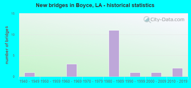
- New bridges - historical statistics
- 11940-1949
- 31960-1969
- 111980-1989
- 11990-1999
- 12000-2009
- 22010-2019


- Bridge Condition - Deck
- 5.6%Excellent
- 5.6%Very good
- 61.1%Good
- 5.6%Satisfactory
- 5.6%Fair
- 16.7%Poor

- Bridge Condition - Superstructure
- 5.6%Excellent
- 5.6%Very good
- 50.0%Good
- 5.6%Satisfactory
- 16.7%Fair
- 16.7%Poor

- Bridge Condition - Substructure
- 5.6%Excellent
- 5.6%Very good
- 55.6%Good
- 16.7%Satisfactory
- 11.1%Poor
- 5.6%Serious

- Bridge Condition - Channel
- 7.7%Excellent
- 7.7%Very good
- 23.1%Good
- 38.5%Satisfactory
- 23.1%Fair
Find on map >> Show street view
Structure Number: 82200000080679, Location: 2.41 Mi E of La 8 (Lat: 31.445381, Lng: -92.639400), Route carried "on" structure: County highway , Year Built: 2017, Status: Open, Structure Length: 7.32m (24.02ft), Average Daily Traffic: 125 (year 2015), Truck Traffic: 1%, Average Future Daily Traffic: 375 (year 2037), Design Load: HL 93, Features Intersected: Darrow Bayou, Facility Carried by Structure: Kateland Road
Minimum Vertical Clearance: 30+ m (98+ ft), Kilometerpoint: 0.000, Lanes on structure: 2, Owner: County Highway Agency, Approaching Roadway Width: 4.6m (15.1ft), Material/Design: Concrete, Design/Construction: Stringer/Multi-beam, Number Of Spans In Main Unit: 6, Length of Maximum Span: 12.2m (40.0ft), Curb-To-Curb Width: 7.2m (23.6ft), Out-to-Out Width: 8.1m (26.6ft)
Condition: Deck: Excellent, Superstructure: Excellent, Substructure: Excellent, Channel: Excellent, Operating Rating: 64.8 metric tons, Method Used To Determine Operating Rating: Load and Resistance Factor Rating (LRFR) rating reported by rating factor(RF) method using HL-93 loadings, Inventory Rating: 38.9 metric tons, Method Used To Determine Inventory Rating: Load and Resistance Factor Rating (LRFR) rating reported by rating factor(RF) method using HL-93 loadings, Structural Evaluation: Superior to present desirable criteria, Deck Geometry: Meets minimum limits, Waterway Adequacy: Superior to present desirable criteria, Approach Roadway Alignment: Equal to present desirable criteria, Designated Inspection Frequency: Every 24 months, Inspection Date: Febuary 2021, Deck Structure Type: Concrete Cast-file-Place
Find on map >> Show street view
Structure Number: 82201510200001, Location: LA 8 OVER RED RIVER AND L (Lat: 31.384419, Lng: -92.664531), Route carried "on" structure: State highway 8, Year Built: 1984, Status: Open, Structure Length: 93.48m (306.69ft), Average Daily Traffic: 2,900 (year 2016), Truck Traffic: 14%, Average Future Daily Traffic: 4,704 (year 2036), Design Load: HS 20, Features Intersected: RED RIVER, LA 1, UP RR
Minimum Vertical Clearance: 30+ m (98+ ft), Kilometerpoint: 0.005, Lanes on structure: 2, Lanes under structure: 4, Owner: State Highway Agency, Approaching Roadway Width: 13.7m (44.9ft), Skew: 31 degrees, Navigation Control: Yes ( Vertical Clearance: 15.9m (52.2ft), Horizontal Clearance: 91.4m (299.9ft)), Material/Design: Concrete continuous, Design/Construction: Segmental Box Girder, Number Of Spans In Main Unit: 6, Number Of Approach Spans: 18, Length of Maximum Span: 112.8m (370.1ft), Curb-To-Curb Width: 12.3m (40.4ft), Out-to-Out Width: 13.0m (42.7ft)
Condition: Deck: Fair, Superstructure: Fair, Substructure: Satisfactory, Channel: Satisfactory, Operating Rating: 52.6 metric tons, Method Used To Determine Operating Rating: Load Factor (LF), Inventory Rating: 32.7 metric tons, Method Used To Determine Inventory Rating: Load Factor (LF), Structural Evaluation: Somewhat better than minimum adequacy, Deck Geometry: Equal to present minimum criteria, Underclear: Better than present minimum criteria, Waterway Adequacy: Better than present minimum criteria, Approach Roadway Alignment: Better than present minimum criteria, Designated Inspection Frequency: Every 24 months, Underwater Inspection Frequency: Every 60 months, Inspection Date: June 2021, Underwater Inspection Date: January 2018, Deck Structure Type: Concrete Cast-file-Place
Find on map >> Show street view
Structure Number: 82201510204251, Location: 4.25 MI EAST OF LA 1 (Lat: 31.448139, Lng: -92.675100), Route carried "on" structure: State highway 8, Year Built: 1948, Status: Open, Structure Length: 1.65m (5.41ft), Average Daily Traffic: 2,700 (year 2016), Truck Traffic: 14%, Average Future Daily Traffic: 4,536 (year 2036), Design Load: H 15, Features Intersected: LITTLE SANDY BAYOU
Minimum Vertical Clearance: 30+ m (98+ ft), Kilometerpoint: 7.636, Lanes on structure: 2, Owner: State Highway Agency, Approaching Roadway Width: 10.4m (34.1ft), Skew: 34 degrees, Material/Design: Concrete, Design/Construction: Culvert, Number Of Spans In Main Unit: 6, Length of Maximum Span: 2.4m (7.9ft)
Condition: Channel: Fair, Culverts: Satisfactory, Operating Rating: 24.9 metric tons, Method Used To Determine Operating Rating: Load and Resistance Factor Rating (LRFR) rating reported by rating factor(RF) method using HL-93 loadings, Inventory Rating: 19.1 metric tons, Method Used To Determine Inventory Rating: Load and Resistance Factor Rating (LRFR) rating reported by rating factor(RF) method using HL-93 loadings, Structural Evaluation: Somewhat better than minimum adequacy, Waterway Adequacy: Equal to present minimum criteria, Approach Roadway Alignment: Better than present minimum criteria, Designated Inspection Frequency: Every 24 months, Inspection Date: July 2020, Deck Structure Type: Concrete Cast-file-Place
Find on map >> Show street view
Structure Number: 82231268923961, Location: 1.16 M. E. OF LA 8 (Lat: 31.446861, Lng: -92.660200), Route carried "on" structure: County highway , Year Built: 2002, Status: Open, Structure Length: 4.82m (15.81ft), Average Daily Traffic: 200 (year 2000), Average Future Daily Traffic: 336 (year 2036), Design Load: HS 20, Features Intersected: PATASSA BAYOU, Facility Carried by Structure: Kateland Gin Rd
Minimum Vertical Clearance: 30+ m (98+ ft), Kilometerpoint: 1.532, Lanes on structure: 2, Owner: County Highway Agency, Approaching Roadway Width: 8.5m (27.9ft), Skew: 36 degrees, Material/Design: Concrete, Design/Construction: Slab, Number Of Spans In Main Unit: 8, Length of Maximum Span: 5.8m (19.0ft), Curb-To-Curb Width: 7.1m (23.3ft), Out-to-Out Width: 8.1m (26.6ft)
Condition: Deck: Very good, Superstructure: Very good, Substructure: Very good, Channel: Very good, Operating Rating: 36.0 metric tons, Method Used To Determine Operating Rating: Load and Resistance Factor Rating (LRFR) rating reported by rating factor(RF) method using HL-93 loadings, Inventory Rating: 27.9 metric tons, Method Used To Determine Inventory Rating: Load and Resistance Factor Rating (LRFR) rating reported by rating factor(RF) method using HL-93 loadings, Structural Evaluation: Better than present minimum criteria, Deck Geometry: Meets minimum limits, Waterway Adequacy: Equal to present desirable criteria, Approach Roadway Alignment: Equal to present desirable criteria, Designated Inspection Frequency: Every 24 months, Inspection Date: Febuary 2021, Deck Structure Type: Concrete Cast-file-Place, Wearing Surface/Protective System: Wearing Surface: Monolithic Concrete
Find on map >> Show street view
Structure Number: 84000000080622, Location: 0.25 MI. NORTH OF LA 121 (Lat: 31.394169, Lng: -92.694100), Route carried "on" structure: State highway 1, Year Built: 2013, Status: Open, Structure Length: 15.24m (50.00ft), Average Daily Traffic: 3,000 (year 2016), Truck Traffic: 14%, Average Future Daily Traffic: 3,900 (year 2036), Design Load: HL 93, Features Intersected: BAYOU JEAN DE JEAN
Minimum Vertical Clearance: 30+ m (98+ ft), Kilometerpoint: 2.358, Lanes on structure: 2, Owner: State Highway Agency, Approaching Roadway Width: 13.4m (44.0ft), Skew: 30 degrees, Material/Design: Prestressed concrete continuous, Design/Construction: Stringer/Multi-beam, Number Of Spans In Main Unit: 4, Number Of Approach Spans: 1, Length of Maximum Span: 30.5m (100.1ft), Curb-To-Curb Width: 13.2m (43.3ft), Out-to-Out Width: 14.2m (46.6ft)
Condition: Deck: Good, Superstructure: Good, Substructure: Good, Channel: Good, Operating Rating: 68.7 metric tons, Method Used To Determine Operating Rating: Load and Resistance Factor Rating (LRFR) rating reported by rating factor(RF) method using HL-93 loadings, Inventory Rating: 45.7 metric tons, Method Used To Determine Inventory Rating: Load and Resistance Factor Rating (LRFR) rating reported by rating factor(RF) method using HL-93 loadings, Structural Evaluation: Better than present minimum criteria, Deck Geometry: Equal to present minimum criteria, Waterway Adequacy: Equal to present desirable criteria, Approach Roadway Alignment: Better than present minimum criteria, Designated Inspection Frequency: Every 24 months, Underwater Inspection Frequency: Every 60 months, Inspection Date: May 2020, Underwater Inspection Date: April 2020, Deck Structure Type: Concrete Cast-file-Place, Wearing Surface/Protective System: Wearing Surface: Monolithic Concrete
Find on map >> Show street view
Structure Number: 84000530113491, Location: 0.6 MI SOUTH LA 1200 (Lat: 31.379469, Lng: -92.653269), Route carried "on" structure: State highway 1, Year Built: 1989, Year Reconstructed: 2016, Status: Open, Structure Length: 18.29m (60.01ft), Average Daily Traffic: 3,000 (year 2016), Truck Traffic: 14%, Average Future Daily Traffic: 3,900 (year 2036), Design Load: HS 20, Features Intersected: LA-1 OVER I-49
Minimum Vertical Clearance: 30+ m (98+ ft), Kilometerpoint: 21.787, Lanes on structure: 2, Lanes under structure: 4, Owner: State Highway Agency, Approaching Roadway Width: 14.0m (45.9ft), Skew: 34 degrees, Material/Design: Steel continuous, Design/Construction: Stringer/Multi-beam, Number Of Spans In Main Unit: 6, Length of Maximum Span: 38.1m (125.0ft), Curb-To-Curb Width: 13.4m (44.0ft), Out-to-Out Width: 14.3m (46.9ft)
Condition: Deck: Good, Superstructure: Good, Substructure: Good, Operating Rating: 44.4 metric tons, Method Used To Determine Operating Rating: Load and Resistance Factor Rating (LRFR) rating reported by rating factor(RF) method using HL-93 loadings, Inventory Rating: 34.3 metric tons, Method Used To Determine Inventory Rating: Load and Resistance Factor Rating (LRFR) rating reported by rating factor(RF) method using HL-93 loadings, Structural Evaluation: Better than present minimum criteria, Deck Geometry: Better than present minimum criteria, Underclear: Equal to present desirable criteria, Approach Roadway Alignment: Superior to present desirable criteria, Length Of Structure Improvement: 13.20m (43.31ft), Designated Inspection Frequency: Every 24 months, Inspection Date: September 2020, Bridge Improvement Cost: $1,238,000, Total Project Cost: $1,857,000 ( Estimate for 2016), Deck Structure Type: Concrete Cast-file-Place, Wearing Surface/Protective System: Wearing Surface: Monolithic Concrete
Find on map >> Show street view
Structure Number: 84001340409951, Location: I-49 / LA 8 INTG. (Lat: 31.409069, Lng: -92.717100), Route carried "on" structure: State highway 8, Year Built: 1984, Status: Open, Structure Length: 9.81m (32.19ft), Average Daily Traffic: 940 (year 2016), Truck Traffic: 14%, Average Future Daily Traffic: 1,222 (year 2036), Design Load: HS 20, Features Intersected: I-49
Minimum Vertical Clearance: 30+ m (98+ ft), Kilometerpoint: 15.543, Lanes on structure: 3, Lanes under structure: 4, Owner: State Highway Agency, Approaching Roadway Width: 11.0m (36.1ft), Skew: 30 degrees, Material/Design: Prestressed concrete continuous, Design/Construction: Stringer/Multi-beam, Number Of Spans In Main Unit: 2, Number Of Approach Spans: 2, Length of Maximum Span: 27.4m (89.9ft), Curb-To-Curb Width: 20.1m (65.9ft), Out-to-Out Width: 21.0m (68.9ft)
Condition: Deck: Good, Superstructure: Good, Substructure: Good, Operating Rating: 88.0 metric tons, Method Used To Determine Operating Rating: Load Factor (LF), Inventory Rating: 52.6 metric tons, Method Used To Determine Inventory Rating: Load Factor (LF), Structural Evaluation: Better than present minimum criteria, Deck Geometry: Superior to present desirable criteria, Underclear: Somewhat better than minimum adequacy, Approach Roadway Alignment: Equal to present desirable criteria, Designated Inspection Frequency: Every 24 months, Inspection Date: July 2020, Deck Structure Type: Concrete Cast-file-Place, Wearing Surface/Protective System: Wearing Surface: Monolithic Concrete
Find on map >> Show street view
Structure Number: 84004550544841, Location: I-49 / LA 1200 INTG. (Lat: 31.379769, Lng: -92.668800), Route carried "on" structure: Interstate 49, Year Built: 1989, Status: Open, Structure Length: 6.49m (21.29ft), Average Daily Traffic: 8,350 (year 2016), Truck Traffic: 30%, Average Future Daily Traffic: 12,792 (year 2036), Design Load: HS 20, Features Intersected: LA 1200
Minimum Vertical Clearance: 30+ m (98+ ft), Kilometerpoint: 72.136, Lanes on structure: 2, Lanes under structure: 4, Base Highway Network: Yes (Inventory Route: 455-05-1, Subroute: 10), Owner: State Highway Agency, Approaching Roadway Width: 12.2m (40.0ft), Skew: 32 degrees, Material/Design: Prestressed concrete continuous, Design/Construction: Stringer/Multi-beam, Number Of Spans In Main Unit: 2, Length of Maximum Span: 32.3m (106.0ft), Curb-To-Curb Width: 12.2m (40.0ft), Out-to-Out Width: 13.0m (42.7ft)
Condition: Deck: Good, Superstructure: Good, Substructure: Good, Operating Rating: 47.2 metric tons, Method Used To Determine Operating Rating: Load Factor (LF), Inventory Rating: 29.0 metric tons, Method Used To Determine Inventory Rating: Load Factor (LF), Structural Evaluation: Better than present minimum criteria, Deck Geometry: Better than present minimum criteria, Underclear: Superior to present desirable criteria, Approach Roadway Alignment: Equal to present desirable criteria, Designated Inspection Frequency: Every 24 months, Inspection Date: October 2020, Deck Structure Type: Concrete Cast-file-Place
Find on map >> Show street view
Structure Number: 84004550544842, Location: I-49 / LA 1200 INTG. (Lat: 31.379569, Lng: -92.669700), Route carried "on" structure: Interstate 49, Year Built: 1989, Status: Open, Structure Length: 6.49m (21.29ft), Average Daily Traffic: 8,350 (year 2016), Truck Traffic: 30%, Average Future Daily Traffic: 12,792 (year 2036), Design Load: HS 20, Features Intersected: LA 1200
Minimum Vertical Clearance: 30+ m (98+ ft), Kilometerpoint: 15.012, Lanes on structure: 2, Lanes under structure: 4, Base Highway Network: Yes (Inventory Route: 455-05-2, Subroute: 10), Owner: State Highway Agency, Approaching Roadway Width: 12.2m (40.0ft), Skew: 32 degrees, Material/Design: Prestressed concrete continuous, Design/Construction: Stringer/Multi-beam, Number Of Spans In Main Unit: 2, Length of Maximum Span: 32.3m (106.0ft), Curb-To-Curb Width: 12.2m (40.0ft), Out-to-Out Width: 13.0m (42.7ft)
Condition: Deck: Good, Superstructure: Good, Substructure: Good, Operating Rating: 47.2 metric tons, Method Used To Determine Operating Rating: Load Factor (LF), Inventory Rating: 29.0 metric tons, Method Used To Determine Inventory Rating: Load Factor (LF), Structural Evaluation: Better than present minimum criteria, Deck Geometry: Better than present minimum criteria, Underclear: Superior to present desirable criteria, Approach Roadway Alignment: Equal to present desirable criteria, Designated Inspection Frequency: Every 24 months, Inspection Date: October 2020, Deck Structure Type: Concrete Cast-file-Place, Wearing Surface/Protective System: Wearing Surface: Monolithic Concrete
Find on map >> Show street view
Structure Number: 84004550546501, Location: 1.65 MI. NORTH OF LA 1200 (Lat: 31.392150, Lng: -92.692100), Route carried "on" structure: Interstate 49, Year Built: 1989, Status: Open, Structure Length: 6.83m (22.41ft), Average Daily Traffic: 8,350 (year 2016), Truck Traffic: 30%, Average Future Daily Traffic: 12,792 (year 2036), Design Load: HS 20, Features Intersected: LA 121
Minimum Vertical Clearance: 30+ m (98+ ft), Kilometerpoint: 74.794, Lanes on structure: 2, Lanes under structure: 2, Base Highway Network: Yes (Inventory Route: 455-05-1, Subroute: 10), Owner: State Highway Agency, Approaching Roadway Width: 12.2m (40.0ft), Skew: 34 degrees, Material/Design: Prestressed concrete, Design/Construction: Stringer/Multi-beam, Number Of Spans In Main Unit: 3, Length of Maximum Span: 27.4m (89.9ft), Curb-To-Curb Width: 12.2m (40.0ft), Out-to-Out Width: 13.0m (42.7ft)
Condition: Deck: Good, Superstructure: Fair, Substructure: Good, Operating Rating: 51.7 metric tons, Method Used To Determine Operating Rating: Load Factor (LF), Inventory Rating: 31.7 metric tons, Method Used To Determine Inventory Rating: Load Factor (LF), Structural Evaluation: Somewhat better than minimum adequacy, Deck Geometry: Better than present minimum criteria, Underclear: Better than present minimum criteria, Approach Roadway Alignment: Equal to present desirable criteria, Designated Inspection Frequency: Every 24 months, Inspection Date: October 2020, Deck Structure Type: Concrete Cast-file-Place, Wearing Surface/Protective System: Wearing Surface: Monolithic Concrete
Find on map >> Show street view
Structure Number: 84004550546502, Location: 1.65 MI. NORTH OF LA 1200 (Lat: 31.392511, Lng: -92.693100), Route carried "on" structure: Interstate 49, Year Built: 1989, Status: Open, Structure Length: 6.83m (22.41ft), Average Daily Traffic: 8,350 (year 2016), Truck Traffic: 30%, Average Future Daily Traffic: 12,792 (year 2036), Design Load: HS 20, Features Intersected: LA 121
Minimum Vertical Clearance: 30+ m (98+ ft), Kilometerpoint: 12.320, Lanes on structure: 2, Lanes under structure: 2, Base Highway Network: Yes (Inventory Route: 455-05-2, Subroute: 10), Owner: State Highway Agency, Approaching Roadway Width: 12.2m (40.0ft), Skew: 34 degrees, Material/Design: Prestressed concrete, Design/Construction: Stringer/Multi-beam, Number Of Spans In Main Unit: 3, Length of Maximum Span: 27.4m (89.9ft), Curb-To-Curb Width: 12.2m (40.0ft), Out-to-Out Width: 13.0m (42.7ft)
Condition: Deck: Good, Superstructure: Fair, Substructure: Good, Operating Rating: 68.9 metric tons, Method Used To Determine Operating Rating: Load Factor (LF), Inventory Rating: 33.6 metric tons, Method Used To Determine Inventory Rating: Load Factor (LF), Structural Evaluation: Somewhat better than minimum adequacy, Deck Geometry: Better than present minimum criteria, Underclear: Equal to present minimum criteria, Approach Roadway Alignment: Equal to present desirable criteria, Designated Inspection Frequency: Every 24 months, Inspection Date: October 2020, Deck Structure Type: Concrete Cast-file-Place, Wearing Surface/Protective System: Wearing Surface: Monolithic Concrete
Find on map >> Show street view
Structure Number: 84004550546671, Location: 1.8 M NORTH OF LA 1200 (Lat: 31.393781, Lng: -92.694400), Route carried "on" structure: Interstate 49, Year Built: 1989, Status: Open, Structure Length: 18.84m (61.81ft), Average Daily Traffic: 8,350 (year 2016), Truck Traffic: 30%, Average Future Daily Traffic: 12,792 (year 2036), Design Load: HS 20, Features Intersected: BAYOU JEAN DE JEAN
Minimum Vertical Clearance: 30+ m (98+ ft), Kilometerpoint: 75.079, Lanes on structure: 2, Base Highway Network: Yes (Inventory Route: 455-05-1, Subroute: 10), Owner: State Highway Agency, Approaching Roadway Width: 12.2m (40.0ft), Skew: 30 degrees, Material/Design: Prestressed concrete continuous, Design/Construction: Stringer/Multi-beam, Number Of Spans In Main Unit: 7, Length of Maximum Span: 26.8m (87.9ft), Curb-To-Curb Width: 12.2m (40.0ft), Out-to-Out Width: 13.0m (42.7ft)
Condition: Deck: Good, Superstructure: Good, Substructure: Satisfactory, Channel: Satisfactory, Operating Rating: 66.2 metric tons, Method Used To Determine Operating Rating: Load Factor (LF), Inventory Rating: 32.7 metric tons, Method Used To Determine Inventory Rating: Load Factor (LF), Structural Evaluation: Equal to present minimum criteria, Deck Geometry: Better than present minimum criteria, Waterway Adequacy: Superior to present desirable criteria, Approach Roadway Alignment: Equal to present desirable criteria, Designated Inspection Frequency: Every 24 months, Underwater Inspection Frequency: Every 60 months, Inspection Date: May 2021, Underwater Inspection Date: May 2018, Deck Structure Type: Concrete Cast-file-Place, Wearing Surface/Protective System: Wearing Surface: Monolithic Concrete
Find on map >> Show street view
Structure Number: 84004550546672, Location: 1.8 M NORTH OF LA 1200 (Lat: 31.394819, Lng: -92.696300), Route carried "on" structure: Interstate 49, Year Built: 1989, Status: Open, Structure Length: 18.84m (61.81ft), Average Daily Traffic: 8,350 (year 2016), Truck Traffic: 30%, Average Future Daily Traffic: 12,792 (year 2036), Design Load: HS 20, Features Intersected: BAYOU JEAN DE JEAN
Minimum Vertical Clearance: 30+ m (98+ ft), Kilometerpoint: 11.916, Lanes on structure: 2, Base Highway Network: Yes (Inventory Route: 455-05-2, Subroute: 10), Owner: State Highway Agency, Approaching Roadway Width: 12.2m (40.0ft), Skew: 30 degrees, Material/Design: Prestressed concrete continuous, Design/Construction: Stringer/Multi-beam, Number Of Spans In Main Unit: 7, Length of Maximum Span: 26.8m (87.9ft), Curb-To-Curb Width: 12.2m (40.0ft), Out-to-Out Width: 13.0m (42.7ft)
Condition: Deck: Good, Superstructure: Good, Substructure: Good, Channel: Good, Operating Rating: 61.7 metric tons, Method Used To Determine Operating Rating: Load Factor (LF), Inventory Rating: 36.3 metric tons, Method Used To Determine Inventory Rating: Load Factor (LF), Structural Evaluation: Better than present minimum criteria, Deck Geometry: Better than present minimum criteria, Waterway Adequacy: Superior to present desirable criteria, Approach Roadway Alignment: Equal to present desirable criteria, Designated Inspection Frequency: Every 24 months, Underwater Inspection Frequency: Every 60 months, Inspection Date: May 2021, Underwater Inspection Date: May 2018, Deck Structure Type: Concrete Cast-file-Place, Wearing Surface/Protective System: Wearing Surface: Monolithic Concrete
Find on map >> Show street view
Structure Number: 84004550547891, Location: 3.23 MI. NORTH OF LA 1200 (Lat: 31.405061, Lng: -92.710400), Route carried "on" structure: Interstate 49, Year Built: 1982, Status: Open, Structure Length: 37.49m (123.00ft), Average Daily Traffic: 8,350 (year 2016), Truck Traffic: 30%, Average Future Daily Traffic: 12,792 (year 2036), Design Load: HS 20, Features Intersected: ROAD, RR, LAKE, CONVEYOR
Minimum Vertical Clearance: 30+ m (98+ ft), Kilometerpoint: 77.044, Lanes on structure: 2, Lanes under structure: 2, Base Highway Network: Yes (Inventory Route: 455-05-1, Subroute: 10), Owner: State Highway Agency, Approaching Roadway Width: 12.2m (40.0ft), Skew: 36 degrees, Material/Design: Prestressed concrete continuous, Design/Construction: Stringer/Multi-beam, Number Of Spans In Main Unit: 11, Number Of Approach Spans: 7, Length of Maximum Span: 30.2m (99.1ft), Curb-To-Curb Width: 12.3m (40.4ft), Out-to-Out Width: 13.0m (42.7ft)
Condition: Deck: Good, Superstructure: Good, Substructure: Good, Channel: Satisfactory, Operating Rating: 79.8 metric tons, Method Used To Determine Operating Rating: Load Factor (LF), Inventory Rating: 39.9 metric tons, Method Used To Determine Inventory Rating: Load Factor (LF), Structural Evaluation: Better than present minimum criteria, Deck Geometry: Better than present minimum criteria, Underclear: Somewhat better than minimum adequacy, Approach Roadway Alignment: Equal to present desirable criteria, Designated Inspection Frequency: Every 24 months, Inspection Date: May 2021, Deck Structure Type: Concrete Cast-file-Place, Wearing Surface/Protective System: Wearing Surface: Monolithic Concrete
Find on map >> Show street view
Structure Number: 84004550547892, Location: 3.0 MI. N OF LA1200 (Lat: 31.406989, Lng: -92.713600), Route carried "on" structure: Interstate 49, Year Built: 1982, Status: Open, Structure Length: 37.49m (123.00ft), Average Daily Traffic: 8,350 (year 2016), Truck Traffic: 30%, Average Future Daily Traffic: 12,792 (year 2036), Design Load: HS 20, Features Intersected: ROAD, RR, LAKE, CONVEYOR
Minimum Vertical Clearance: 30+ m (98+ ft), Kilometerpoint: 9.791, Lanes on structure: 3, Lanes under structure: 2, Base Highway Network: Yes (Inventory Route: 455-05-2, Subroute: 10), Owner: State Highway Agency, Approaching Roadway Width: 19.5m (64.0ft), Skew: 36 degrees, Material/Design: Prestressed concrete continuous, Design/Construction: Stringer/Multi-beam, Number Of Spans In Main Unit: 16, Number Of Approach Spans: 2, Length of Maximum Span: 30.2m (99.1ft), Curb-To-Curb Width: 15.9m (52.2ft), Out-to-Out Width: 16.7m (54.8ft)
Condition: Deck: Good, Superstructure: Good, Substructure: Good, Channel: Satisfactory, Operating Rating: 52.6 metric tons, Method Used To Determine Operating Rating: Load Factor (LF), Inventory Rating: 31.7 metric tons, Method Used To Determine Inventory Rating: Load Factor (LF), Structural Evaluation: Better than present minimum criteria, Deck Geometry: Somewhat better than minimum adequacy, Underclear: Superior to present desirable criteria, Approach Roadway Alignment: Equal to present desirable criteria, Designated Inspection Frequency: Every 24 months, Inspection Date: May 2021, Deck Structure Type: Concrete Cast-file-Place, Wearing Surface/Protective System: Wearing Surface: Monolithic Concrete
Find on map >> Show street view
Structure Number: 84008402600951, Location: .95 MI. N OF LA121 (Lat: 31.342781, Lng: -92.676200), Route carried "on" structure: State highway 1200, Year Built: 1960, Status: Posted for load, Structure Length: 1.16m (3.81ft), Average Daily Traffic: 1,340 (year 2016), Truck Traffic: 14%, Average Future Daily Traffic: 1,755 (year 2036), Design Load: HS 20, Features Intersected: CREEK
Minimum Vertical Clearance: 30+ m (98+ ft), Kilometerpoint: 1.513, Lanes on structure: 2, Owner: State Highway Agency, Approaching Roadway Width: 9.1m (29.9ft), Skew: 30 degrees, Material/Design: Concrete, Design/Construction: Slab, Number Of Spans In Main Unit: 2, Length of Maximum Span: 5.8m (19.0ft), Curb-To-Curb Width: 7.4m (24.3ft), Out-to-Out Width: 7.8m (25.6ft)
Condition: Deck: Poor, Superstructure: Poor, Substructure: Serious, Channel: Fair, Operating Rating: 19.1 metric tons, Method Used To Determine Operating Rating: Load and Resistance Factor Rating (LRFR) rating reported by rating factor(RF) method using HL-93 loadings, Inventory Rating: 14.9 metric tons, Method Used To Determine Inventory Rating: Load and Resistance Factor Rating (LRFR) rating reported by rating factor(RF) method using HL-93 loadings, Structural Evaluation: High priority of corrective action, Deck Geometry: Meets minimum limits, Waterway Adequacy: Equal to present minimum criteria, Approach Roadway Alignment: Equal to present desirable criteria, Bridge Posting: Required (Relationship of Operating Rating to Maximum Legal Load: 20.0 - 29.9% below), Length Of Structure Improvement: 1.80m (5.91ft), Designated Inspection Frequency: Every 24 months, Other Special Inspection Frequency: Every 12 months, Inspection Date: December 2020, Other Special Inspection Date: December 2021, Bridge Improvement Cost: $153,000, Total Project Cost: $229,000 ( Estimate for 2016), Deck Structure Type: Concrete Precast Panels, Wearing Surface/Protective System: Wearing Surface: Bituminous
Find on map >> Show street view
Structure Number: 84008402601501, Location: 1.50 MI. N OF LA121 (Lat: 31.349739, Lng: -92.672700), Route carried "on" structure: State highway 1200, Year Built: 1960, Status: Posted for load, Structure Length: 1.74m (5.71ft), Average Daily Traffic: 1,340 (year 2016), Truck Traffic: 14%, Average Future Daily Traffic: 1,755 (year 2036), Design Load: HS 20, Features Intersected: BAYOU COCODRIE
Minimum Vertical Clearance: 30+ m (98+ ft), Kilometerpoint: 2.356, Lanes on structure: 2, Owner: State Highway Agency, Approaching Roadway Width: 9.1m (29.9ft), Skew: 30 degrees, Material/Design: Concrete, Design/Construction: Slab, Number Of Spans In Main Unit: 3, Length of Maximum Span: 5.8m (19.0ft), Curb-To-Curb Width: 7.4m (24.3ft), Out-to-Out Width: 7.8m (25.6ft)
Condition: Deck: Poor, Superstructure: Poor, Substructure: Poor, Channel: Satisfactory, Operating Rating: 25.3 metric tons, Method Used To Determine Operating Rating: Load and Resistance Factor Rating (LRFR) rating reported by rating factor(RF) method using HL-93 loadings, Inventory Rating: 12.0 metric tons, Method Used To Determine Inventory Rating: Load and Resistance Factor Rating (LRFR) rating reported by rating factor(RF) method using HL-93 loadings, Structural Evaluation: High priority of replacement, Deck Geometry: Meets minimum limits, Waterway Adequacy: Equal to present minimum criteria, Approach Roadway Alignment: Equal to present desirable criteria, Bridge Posting: Required (Relationship of Operating Rating to Maximum Legal Load: 30.0 - 39.9% below), Length Of Structure Improvement: 2.44m (8.01ft), Designated Inspection Frequency: Every 24 months, Other Special Inspection Frequency: Every 12 months, Inspection Date: December 2020, Other Special Inspection Date: December 2021, Bridge Improvement Cost: $208,000, Total Project Cost: $312,000 ( Estimate for 2016), Deck Structure Type: Concrete Precast Panels, Wearing Surface/Protective System: Wearing Surface: Bituminous
Find on map >> Show street view
Structure Number: 84008402603361, Location: 3.36 MI. N OF LA121 (Lat: 31.375069, Lng: -92.671300), Route carried "on" structure: State highway 1200, Year Built: 1960, Status: Posted for load, Structure Length: 1.16m (3.81ft), Average Daily Traffic: 1,340 (year 2016), Truck Traffic: 14%, Average Future Daily Traffic: 1,755 (year 2036), Design Load: HS 20, Features Intersected: BAYOU BERTRAND
Minimum Vertical Clearance: 30+ m (98+ ft), Kilometerpoint: 5.383, Lanes on structure: 2, Owner: State Highway Agency, Approaching Roadway Width: 9.1m (29.9ft), Skew: 30 degrees, Material/Design: Concrete, Design/Construction: Slab, Number Of Spans In Main Unit: 2, Length of Maximum Span: 5.8m (19.0ft), Curb-To-Curb Width: 7.4m (24.3ft), Out-to-Out Width: 7.8m (25.6ft)
Condition: Deck: Poor, Superstructure: Poor, Substructure: Poor, Channel: Fair, Operating Rating: 19.8 metric tons, Method Used To Determine Operating Rating: Load and Resistance Factor Rating (LRFR) rating reported by rating factor(RF) method using HL-93 loadings, Inventory Rating: 14.9 metric tons, Method Used To Determine Inventory Rating: Load and Resistance Factor Rating (LRFR) rating reported by rating factor(RF) method using HL-93 loadings, Structural Evaluation: Meets minimum limits, Deck Geometry: Meets minimum limits, Waterway Adequacy: Equal to present desirable criteria, Approach Roadway Alignment: Equal to present desirable criteria, Bridge Posting: Required (Relationship of Operating Rating to Maximum Legal Load: 10.0 - 19.9% below), Length Of Structure Improvement: 1.80m (5.91ft), Designated Inspection Frequency: Every 24 months, Other Special Inspection Frequency: Every 12 months, Inspection Date: December 2020, Other Special Inspection Date: December 2021, Bridge Improvement Cost: $153,000, Total Project Cost: $229,000 ( Estimate for 2016), Deck Structure Type: Concrete Precast Panels, Wearing Surface/Protective System: Wearing Surface: Bituminous
Find on map >> Show street view
Structure Number: 84031222924331, Location: 0.05 MI. NORTH OF LA 121 (Lat: 31.370611, Lng: -92.722500), Route carried "on" structure: County highway , Year Built: 1997, Status: Open, Structure Length: 4.63m (15.19ft), Average Daily Traffic: 240 (year 1996), Average Future Daily Traffic: 312 (year 2036), Design Load: HS 20, Features Intersected: BAYOU JEAN DE JEAN, Facility Carried by Structure: Red Store Hill Rd
Minimum Vertical Clearance: 30+ m (98+ ft), Kilometerpoint: 4.284, Lanes on structure: 2, Owner: County Highway Agency, Approaching Roadway Width: 8.5m (27.9ft), Skew: 30 degrees, Material/Design: Concrete, Design/Construction: Slab, Number Of Spans In Main Unit: 8, Length of Maximum Span: 5.8m (19.0ft), Curb-To-Curb Width: 7.4m (24.3ft), Out-to-Out Width: 8.2m (26.9ft)
Condition: Deck: Satisfactory, Superstructure: Satisfactory, Substructure: Satisfactory, Channel: Good, Operating Rating: 32.1 metric tons, Method Used To Determine Operating Rating: Load and Resistance Factor Rating (LRFR) rating reported by rating factor(RF) method using HL-93 loadings, Inventory Rating: 24.9 metric tons, Method Used To Determine Inventory Rating: Load and Resistance Factor Rating (LRFR) rating reported by rating factor(RF) method using HL-93 loadings, Structural Evaluation: Equal to present minimum criteria, Deck Geometry: Somewhat better than minimum adequacy, Waterway Adequacy: Equal to present minimum criteria, Approach Roadway Alignment: Better than present minimum criteria, Designated Inspection Frequency: Every 24 months, Inspection Date: August 2021, Deck Structure Type: Concrete Cast-file-Place, Wearing Surface/Protective System: Wearing Surface: Monolithic Concrete
Find on map >> Show street view
Structure Number: 82201510200001, Location: 0.43 M N of I-49 (Lat: 31.384689, Lng: -92.664200), Route carried "under" structure: State highway 1, Structure Length: 0. m, Average Daily Traffic: 3,400 (year 2017), Features Intersected: LA 1 under LA 8
Minimum Vertical Clearance: 4.94m (16.21ft), Kilometerpoint: 22.999, Lanes on structure: 2, Lanes under structure: 2, Length of Maximum Span: 0.0m
Find on map >> Show street view
Structure Number: 84000530113491, Location: 1.0 MI S OF LA 8 (Lat: 31.379919, Lng: -92.653919), Route carried "under" structure: Interstate 49, Structure Length: 0. m, Average Daily Traffic: 16,400 (year 2014), Features Intersected: I-49 S UNDER LA 1
Minimum Vertical Clearance: 5.36m (17.59ft), Kilometerpoint: 16.510, Lanes on structure: 2, Length of Maximum Span: 0.0m
Find on map >> Show street view
Structure Number: 84000530113491, Location: 1.0 MI S OF LA 8 (Lat: 31.380181, Lng: -92.653969), Route carried "under" structure: Interstate 49, Structure Length: 0. m, Average Daily Traffic: 16,400 (year 2014), Features Intersected: I-49 N UNDER LA 1
Minimum Vertical Clearance: 5.18m (16.99ft), Kilometerpoint: 70.721, Lanes on structure: 2, Length of Maximum Span: 0.0m
Find on map >> Show street view
Structure Number: 84001340409951, Location: 3.5 MI N OF LA 1200 (Lat: 31.409431, Lng: -92.717019), Route carried "under" structure: Interstate 49, Structure Length: 0. m, Average Daily Traffic: 18,900 (year 2014), Features Intersected: I-49 SB UNDER LA 8 FLATW
Minimum Vertical Clearance: 5.15m (16.90ft), Kilometerpoint: 9.370, Lanes on structure: 2, Length of Maximum Span: 0.0m
Find on map >> Show street view
Structure Number: 84001340409951, Location: 3.5 MI N OF LA 1200 (Lat: 31.409239, Lng: -92.716539), Route carried "under" structure: Interstate 49, Structure Length: 0. m, Average Daily Traffic: 18,900 (year 2014), Features Intersected: I-49 NB UNDER LA 8 FLATW
Minimum Vertical Clearance: 5.00m (16.40ft), Kilometerpoint: 77.820, Lanes on structure: 2, Length of Maximum Span: 0.0m
Find on map >> Show street view
Structure Number: 84004550544841, Location: 9.3 MI N OF LA 498 (Lat: 31.379839, Lng: -92.669261), Route carried "under" structure: Alternate State highway 1200, Structure Length: 0. m, Average Daily Traffic: 1,350 (year 2015), Features Intersected: LA 1200 W UNDER I-49 N
Minimum Vertical Clearance: 5.06m (16.60ft), Kilometerpoint: 0.814, Lanes on structure: 2, Length of Maximum Span: 0.0m
Find on map >> Show street view
Structure Number: 84004550544841, Location: 9.3 MI N OF LA 498 (Lat: 31.379711, Lng: -92.669081), Route carried "under" structure: Alternate State highway 1200, Structure Length: 0. m, Average Daily Traffic: 1,350 (year 2015), Features Intersected: LA 1200 E UNDER I-49 N
Minimum Vertical Clearance: 5.06m (16.60ft), Kilometerpoint: 5.940, Lanes on structure: 2, Length of Maximum Span: 0.0m
Find on map >> Show street view
Structure Number: 84004550544842, Location: 9.3 MI N OF LA 498 (Lat: 31.379469, Lng: -92.669231), Route carried "under" structure: Alternate State highway 1200, Structure Length: 0. m, Average Daily Traffic: 1,350 (year 2015), Features Intersected: LA 1200 E UNDER I-49 S
Minimum Vertical Clearance: 5.46m (17.91ft), Kilometerpoint: 5.911, Lanes on structure: 2, Length of Maximum Span: 0.0m
Find on map >> Show street view
Structure Number: 84004550544842, Location: 9.3 MI N OF LA 498 (Lat: 31.379600, Lng: -92.669400), Route carried "under" structure: Alternate State highway 1200, Structure Length: 0. m, Average Daily Traffic: 1,350 (year 2015), Features Intersected: LA 1200 W UNDER I-49 S
Minimum Vertical Clearance: 5.40m (17.72ft), Kilometerpoint: 0.845, Lanes on structure: 2, Length of Maximum Span: 0.0m
Find on map >> Show street view
Structure Number: 84004550546501, Location: 0.1 MI W OF LA 1 (Lat: 31.392339, Lng: -92.692519), Route carried "under" structure: State highway 121, Structure Length: 0. m, Average Daily Traffic: 930 (year 2014), Features Intersected: 121 UNDER I-49 NB
Minimum Vertical Clearance: 4.69m (15.39ft), Kilometerpoint: 15.221, Lanes on structure: 2, Length of Maximum Span: 0.0m
Find on map >> Show street view
Structure Number: 84004550546502, Location: 0.1 MI W OF LA 1 (Lat: 31.392289, Lng: -92.692519), Route carried "under" structure: State highway 121, Structure Length: 0. m, Average Daily Traffic: 930 (year 2014), Features Intersected: 121 UNDER I-49 SB
Minimum Vertical Clearance: 4.63m (15.19ft), Kilometerpoint: 15.181, Lanes on structure: 2, Length of Maximum Span: 0.0m