Bridge Statistics for Brasher, New York (NY)
Condition, Traffic, Stress, Structural Evaluation, Project Costs
- National Bridge Inventory (NBI) Statistics
- 12Number of bridges
- 141ft / 42.9mTotal length
- $18,282,000Total costs
- 10,118Total average daily traffic
- 664Total average daily truck traffic
- 13,326Total future (year 2036) average daily traffic
- National Bridge Inventory (NBI) Registered Bridges for Brasher
- No street view available for this location
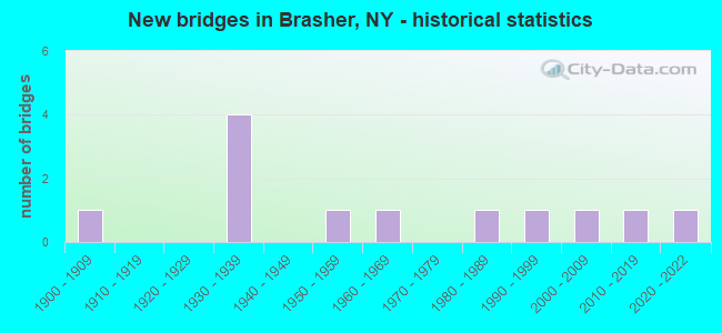
- New bridges - historical statistics
- 11900-1909
- 41930-1939
- 11950-1959
- 11960-1969
- 11980-1989
- 11990-1999
- 12000-2009
- 12010-2019
- 12020-2022

- Reconstructed bridges - Historical Statistics
- 21970-1979
- 21980-1989
- 11990-1999
- 12000-2009

- Bridge Condition - Deck
- 27.3%Excellent
- 9.1%Very good
- 36.4%Good
- 18.2%Fair
- 9.1%Poor

- Bridge Condition - Superstructure
- 33.3%Excellent
- 16.7%Very good
- 16.7%Good
- 16.7%Satisfactory
- 8.3%Fair
- 8.3%Poor

- Bridge Condition - Substructure
- 16.7%Excellent
- 33.3%Very good
- 16.7%Good
- 25.0%Satisfactory
- 8.3%Fair

- Bridge Condition - Channel
- 41.7%Very good
- 33.3%Good
- 16.7%Satisfactory
- 8.3%Fair
Find on map >> Show street view
Structure Number: 100886, Location: 1.4 MI NE JCT US11C & SH4 (Lat: 44.807861, Lng: -74.772431), Route carried "on" structure: US 11C, Year Built: 1933, Year Reconstructed: 1994, Status: Open, Structure Length: 1.22m (4.00ft), Average Daily Traffic: 1,173 (year 2019), Truck Traffic: 7%, Average Future Daily Traffic: 1,223 (year 2040), Design Load: HS 25 or greater, Features Intersected: ST REGIS RIVER
Minimum Vertical Clearance: 30+ m (98+ ft), Kilometerpoint: 7.047, Lanes on structure: 2, Base Highway Network: Yes, Owner: State Highway Agency, Approaching Roadway Width: 9.1m (29.9ft), Material/Design: Prestressed concrete, Design/Construction: Box Beam or Girders - Multiple, Number Of Spans In Main Unit: 1, Length of Maximum Span: 11.5m (37.7ft), Curb or Sidewalk Widths: Left: 1.5m (4.9ft), Right: 0.0m, Curb-To-Curb Width: 9.2m (30.2ft), Out-to-Out Width: 11.3m (37.1ft)
Condition: Deck: Good, Superstructure: Very good, Substructure: Satisfactory, Channel: Good, Operating Rating: 81.6 metric tons, Method Used To Determine Operating Rating: Load Factor (LF), Inventory Rating: 40.8 metric tons, Method Used To Determine Inventory Rating: Load Factor (LF), Structural Evaluation: Equal to present minimum criteria, Deck Geometry: Somewhat better than minimum adequacy, Waterway Adequacy: Somewhat better than minimum adequacy, Approach Roadway Alignment: Equal to present desirable criteria, Length Of Structure Improvement: 1.21m (3.97ft), Designated Inspection Frequency: Every 24 months, Inspection Date: September 2020, Bridge Improvement Cost: $384,000, Roadway Improvement Cost: $225,000, Total Project Cost: $609,000 ( Estimate for 2021), Wearing Surface/Protective System: Wearing Surface: Monolithic Concrete
Find on map >> Show street view
Structure Number: 100887, Location: 1.4 MI NE JCT 11C & 420 (Lat: 44.807978, Lng: -74.771714), Route carried "on" structure: State highway 11C, Year Built: 1933, Year Reconstructed: 1994, Status: Open, Structure Length: 4.72m (15.49ft), Average Daily Traffic: 1,173 (year 2019), Truck Traffic: 7%, Average Future Daily Traffic: 1,223 (year 2040), Design Load: HS 20, Features Intersected: ST REGIS RIVER
Minimum Vertical Clearance: 7.32m (24.02ft), Kilometerpoint: 7.080, Lanes on structure: 2, Base Highway Network: Yes, Owner: State Highway Agency, Approaching Roadway Width: 7.3m (24.0ft), Material/Design: Steel, Design/Construction: Truss - Thru, Number Of Spans In Main Unit: 1, Length of Maximum Span: 45.7m (149.9ft), Curb or Sidewalk Widths: Left: 1.5m (4.9ft), Right: 0.0m, Curb-To-Curb Width: 7.3m (24.0ft), Out-to-Out Width: 8.3m (27.2ft)
Condition: Deck: Good, Superstructure: Satisfactory, Substructure: Good, Channel: Good, Operating Rating: 50.8 metric tons, Method Used To Determine Operating Rating: Load Factor (LF), Inventory Rating: 30.8 metric tons, Method Used To Determine Inventory Rating: Load Factor (LF), Structural Evaluation: Equal to present minimum criteria, Deck Geometry: Meets minimum limits, Waterway Adequacy: Somewhat better than minimum adequacy, Approach Roadway Alignment: Equal to present desirable criteria, Length Of Structure Improvement: 4.72m (15.49ft), Designated Inspection Frequency: Every 24 months, Critical Feature Inspection Frequency: Every 24 months, Inspection Date: September 2020, Critical Feature Inspection Date: September 2020, Bridge Improvement Cost: $2,423,000, Roadway Improvement Cost: $1,419,000, Total Project Cost: $3,842,000 ( Estimate for 2021), Deck Structure Type: Concrete Cast-file-Place, Wearing Surface/Protective System: Wearing Surface: Integral Concrete, Deck Protection: Epoxy Coated Reinforcing
Find on map >> Show street view
Structure Number: 102403, Location: JCT RTE 37C + ST.REGIS R (Lat: 44.924617, Lng: -74.722744), Route carried "on" structure: State highway 37C, Year Built: 1959, Year Reconstructed: 1981, Status: Open, Structure Length: 9.27m (30.41ft), Average Daily Traffic: 2,822 (year 2016), Truck Traffic: 5%, Average Future Daily Traffic: 3,951 (year 2036), Design Load: HS 20, Features Intersected: ST REGIS RIVER
Minimum Vertical Clearance: 30+ m (98+ ft), Kilometerpoint: 8.302, Lanes on structure: 2, Base Highway Network: Yes, Owner: State Highway Agency, Approaching Roadway Width: 10.7m (35.1ft), Material/Design: Prestressed concrete continuous, Design/Construction: Box Beam or Girders - Multiple, Number Of Spans In Main Unit: 4, Length of Maximum Span: 22.5m (73.8ft), Curb-To-Curb Width: 10.7m (35.1ft), Out-to-Out Width: 11.4m (37.4ft)
Condition: Deck: Fair, Superstructure: Satisfactory, Substructure: Good, Channel: Satisfactory, Inventory Rating: 66.2 metric tons, Method Used To Determine Inventory Rating: Load Factor (LF), Structural Evaluation: Equal to present minimum criteria, Deck Geometry: Somewhat better than minimum adequacy, Waterway Adequacy: Somewhat better than minimum adequacy, Approach Roadway Alignment: Equal to present desirable criteria, Length Of Structure Improvement: 9.26m (30.38ft), Designated Inspection Frequency: Every 24 months, Inspection Date: August 2021, Bridge Improvement Cost: $1,549,000, Roadway Improvement Cost: $907,000, Total Project Cost: $2,456,000 ( Estimate for 2021), Wearing Surface/Protective System: Wearing Surface: Integral Concrete
Find on map >> Show street view
Structure Number: 22208, Location: 3 MILES EAST OF HELENA (Lat: 44.924369, Lng: -74.676725), Route carried "on" structure: Other road , Year Built: 1902, Status: Open, Structure Length: 0.79m (2.59ft), Average Daily Traffic: 61 (year 2016), Truck Traffic: 5%, Average Future Daily Traffic: 85 (year 2036), Features Intersected: HUNKINS MARSH, Facility Carried by Structure: KEENAN ROAD
Minimum Vertical Clearance: 30+ m (98+ ft), Kilometerpoint: 2.301, Lanes on structure: 2, Owner: Town or Township Highway Agency, Approaching Roadway Width: 5.5m (18.0ft), Material/Design: Steel, Design/Construction: Arch - Deck, Number Of Spans In Main Unit: 1, Length of Maximum Span: 7.6m (24.9ft), Curb-To-Curb Width: 6.2m (20.3ft), Out-to-Out Width: 6.9m (22.6ft)
Condition: Superstructure: Poor, Substructure: Fair, Channel: Satisfactory, Operating Rating: 48.9 metric tons, Method Used To Determine Operating Rating: Field evaluation and documented engineering judgment, Inventory Rating: 14.2 metric tons, Method Used To Determine Inventory Rating: Field evaluation and documented engineering judgment, Structural Evaluation: Meets minimum limits, Deck Geometry: Somewhat better than minimum adequacy, Waterway Adequacy: Somewhat better than minimum adequacy, Approach Roadway Alignment: Equal to present desirable criteria, Length Of Structure Improvement: 0.79m (2.59ft), Designated Inspection Frequency: Every 24 months, Inspection Date: May 2020, Bridge Improvement Cost: $93,000, Roadway Improvement Cost: $54,000, Total Project Cost: $147,000 ( Estimate for 2021), Wearing Surface/Protective System: Wearing Surface: Bituminous
Find on map >> Show street view
Structure Number: 322085, Location: LOCATED IN HELENA (Lat: 44.919706, Lng: -74.722447), Route carried "on" structure: County highway , Year Built: 2021, Status: Open, Structure Length: 5.36m (17.59ft), Average Daily Traffic: 1,398 (year 2019), Truck Traffic: 8%, Average Future Daily Traffic: 1,957 (year 2039), Design Load: HL 93, Features Intersected: DEER RIVER, Facility Carried by Structure: DEPOT ST
Minimum Vertical Clearance: 32.69m (107.25ft), Kilometerpoint: 0.032, Lanes on structure: 2, Owner: County Highway Agency, Approaching Roadway Width: 9.1m (29.9ft), Material/Design: Steel, Design/Construction: Stringer/Multi-beam, Number Of Spans In Main Unit: 1, Length of Maximum Span: 51.8m (169.9ft), Curb-To-Curb Width: 9.1m (29.9ft), Out-to-Out Width: 10.1m (33.1ft)
Condition: Deck: Excellent, Superstructure: Excellent, Substructure: Excellent, Channel: Very good, Operating Rating: 59.0 metric tons, Method Used To Determine Operating Rating: Load Factor (LF), Inventory Rating: 33.6 metric tons, Method Used To Determine Inventory Rating: Load Factor (LF), Structural Evaluation: Superior to present desirable criteria, Deck Geometry: Somewhat better than minimum adequacy, Waterway Adequacy: Equal to present minimum criteria, Approach Roadway Alignment: Equal to present desirable criteria, Length Of Structure Improvement: 4.54m (14.90ft), Designated Inspection Frequency: Every 24 months, Inspection Date: November 2021, Bridge Improvement Cost: $2,842,000, Roadway Improvement Cost: $1,664,000, Total Project Cost: $4,506,000 ( Estimate for 2021), Deck Structure Type: Concrete Cast-file-Place, Wearing Surface/Protective System: Wearing Surface: Integral Concrete, Deck Protection: Epoxy Coated Reinforcing
Find on map >> Show street view
Structure Number: 334053, Location: 2.0 MI E OF HELENA (Lat: 44.929442, Lng: -74.682364), Route carried "on" structure: County highway , Year Built: 1934, Year Reconstructed: 1983, Status: Open, Structure Length: 1.22m (4.00ft), Average Daily Traffic: 1,199 (year 2019), Truck Traffic: 8%, Average Future Daily Traffic: 1,679 (year 2039), Features Intersected: HUNKINS MARSH, Facility Carried by Structure: CR 37, HELENA-BOM
Minimum Vertical Clearance: 30+ m (98+ ft), Kilometerpoint: 2.574, Lanes on structure: 2, Owner: County Highway Agency, Approaching Roadway Width: 7.6m (24.9ft), Material/Design: Steel, Design/Construction: Stringer/Multi-beam, Number Of Spans In Main Unit: 1, Length of Maximum Span: 11.3m (37.1ft), Curb-To-Curb Width: 10.7m (35.1ft), Out-to-Out Width: 11.9m (39.0ft)
Condition: Deck: Fair, Superstructure: Good, Substructure: Satisfactory, Channel: Good, Operating Rating: 88.0 metric tons, Method Used To Determine Operating Rating: Load Factor (LF), Inventory Rating: 52.6 metric tons, Method Used To Determine Inventory Rating: Load Factor (LF), Structural Evaluation: Equal to present minimum criteria, Deck Geometry: Equal to present minimum criteria, Waterway Adequacy: Somewhat better than minimum adequacy, Approach Roadway Alignment: Equal to present desirable criteria, Length Of Structure Improvement: 1.21m (3.97ft), Designated Inspection Frequency: Every 24 months, Inspection Date: October 2021, Bridge Improvement Cost: $388,000, Roadway Improvement Cost: $227,000, Total Project Cost: $615,000 ( Estimate for 2021), Deck Structure Type: Concrete Cast-file-Place, Wearing Surface/Protective System: Wearing Surface: Bituminous
Find on map >> Show street view
Structure Number: 334054, Location: 2 MILES SW OF HELENA (Lat: 44.896739, Lng: -74.757653), Route carried "on" structure: County highway , Year Built: 1999, Status: Open, Structure Length: 8.20m (26.90ft), Average Daily Traffic: 788 (year 2019), Truck Traffic: 9%, Average Future Daily Traffic: 1,103 (year 2039), Design Load: HS 25 or greater, Features Intersected: ST REGIS RIVER, Facility Carried by Structure: CR 53, BRASHER FL
Minimum Vertical Clearance: 30+ m (98+ ft), Kilometerpoint: 11.520, Lanes on structure: 2, Owner: County Highway Agency, Approaching Roadway Width: 8.5m (27.9ft), Skew: 3 degrees, Material/Design: Steel continuous, Design/Construction: Stringer/Multi-beam, Number Of Spans In Main Unit: 2, Length of Maximum Span: 40.2m (131.9ft), Curb-To-Curb Width: 8.4m (27.6ft), Out-to-Out Width: 9.4m (30.8ft)
Condition: Deck: Good, Superstructure: Very good, Substructure: Very good, Channel: Good, Operating Rating: 70.8 metric tons, Method Used To Determine Operating Rating: Load Factor (LF), Inventory Rating: 41.7 metric tons, Method Used To Determine Inventory Rating: Load Factor (LF), Structural Evaluation: Equal to present desirable criteria, Deck Geometry: Somewhat better than minimum adequacy, Waterway Adequacy: Somewhat better than minimum adequacy, Approach Roadway Alignment: Equal to present desirable criteria, Length Of Structure Improvement: 8.19m (26.87ft), Designated Inspection Frequency: Every 24 months, Inspection Date: August 2021, Bridge Improvement Cost: $1,546,000, Roadway Improvement Cost: $906,000, Total Project Cost: $2,452,000 ( Estimate for 2021), Deck Structure Type: Concrete Cast-file-Place, Wearing Surface/Protective System: Wearing Surface: Integral Concrete, Deck Protection: Epoxy Coated Reinforcing
Find on map >> Show street view
Structure Number: 334055, Location: 1 MI N OF NORTH LAWRENCE (Lat: 44.820006, Lng: -74.681675), Route carried "on" structure: County highway , Year Built: 1960, Year Reconstructed: 2009, Status: Open, Structure Length: 1.89m (6.20ft), Average Daily Traffic: 553 (year 2019), Truck Traffic: 7%, Average Future Daily Traffic: 774 (year 2039), Design Load: HS 25 or greater, Features Intersected: DEER RIVER, Facility Carried by Structure: CR 55, YOUMMELL R
Minimum Vertical Clearance: 30+ m (98+ ft), Kilometerpoint: 1.561, Lanes on structure: 2, Owner: County Highway Agency, Approaching Roadway Width: 6.1m (20.0ft), Material/Design: Steel, Design/Construction: Stringer/Multi-beam, Number Of Spans In Main Unit: 1, Length of Maximum Span: 18.2m (59.7ft), Curb-To-Curb Width: 7.3m (24.0ft), Out-to-Out Width: 7.5m (24.6ft)
Condition: Deck: Very good, Superstructure: Excellent, Substructure: Excellent, Channel: Very good, Operating Rating: 73.2 metric tons, Method Used To Determine Operating Rating: Load and Resistance Factor Rating (LRFR) rating reported by rating factor(RF) method using HL-93 loadings, Inventory Rating: 56.7 metric tons, Method Used To Determine Inventory Rating: Load and Resistance Factor Rating (LRFR) rating reported by rating factor(RF) method using HL-93 loadings, Structural Evaluation: Superior to present desirable criteria, Deck Geometry: Meets minimum limits, Waterway Adequacy: Equal to present minimum criteria, Approach Roadway Alignment: Equal to present desirable criteria, Length Of Structure Improvement: 1.88m (6.17ft), Designated Inspection Frequency: Every 24 months, Inspection Date: June 2021, Bridge Improvement Cost: $423,000, Roadway Improvement Cost: $248,000, Total Project Cost: $671,000 ( Estimate for 2021), Deck Structure Type: Other, Wearing Surface/Protective System: Wearing Surface: Bituminous
Find on map >> Show street view
Structure Number: 334056, Location: 3 MI N OF NORTH LAWRENCE (Lat: 44.844444, Lng: -74.686769), Route carried "on" structure: County highway , Year Built: 2017, Status: Open, Structure Length: 3.26m (10.70ft), Average Daily Traffic: 371 (year 2018), Truck Traffic: 5%, Average Future Daily Traffic: 519 (year 2038), Features Intersected: DEER RIVER, Facility Carried by Structure: CR 55, YOUMMELL R
Minimum Vertical Clearance: 30+ m (98+ ft), Kilometerpoint: 4.312, Lanes on structure: 2, Owner: County Highway Agency, Approaching Roadway Width: 5.8m (19.0ft), Material/Design: Prestressed concrete, Design/Construction: Box Beam or Girders - Multiple, Number Of Spans In Main Unit: 1, Length of Maximum Span: 32.3m (106.0ft), Curb-To-Curb Width: 7.3m (24.0ft), Out-to-Out Width: 8.4m (27.6ft)
Condition: Deck: Excellent, Superstructure: Excellent, Substructure: Very good, Channel: Very good, Inventory Rating: 68.0 metric tons, Method Used To Determine Inventory Rating: Load Factor (LF), Structural Evaluation: Equal to present desirable criteria, Deck Geometry: Somewhat better than minimum adequacy, Waterway Adequacy: Somewhat better than minimum adequacy, Approach Roadway Alignment: Equal to present minimum criteria, Length Of Structure Improvement: 3.26m (10.70ft), Designated Inspection Frequency: Every 24 months, Inspection Date: November 2021, Bridge Improvement Cost: $384,000, Roadway Improvement Cost: $225,000, Total Project Cost: $609,000 ( Estimate for 2021), Deck Structure Type: Other, Wearing Surface/Protective System: Wearing Surface: Bituminous, Membrane: Other
Find on map >> Show street view
Structure Number: 334058, Location: LOCATED IN BRASHER IRON W (Lat: 44.892389, Lng: -74.693356), Route carried "on" structure: Other road , Year Built: 2008, Status: Open, Structure Length: 3.05m (10.01ft), Average Daily Traffic: 138 (year 2018), Truck Traffic: 2%, Average Future Daily Traffic: 193 (year 2038), Design Load: HL 93, Features Intersected: DEER RIVER, Facility Carried by Structure: SMITH ROAD
Minimum Vertical Clearance: 30+ m (98+ ft), Kilometerpoint: 0.499, Lanes on structure: 2, Owner: County Highway Agency, Approaching Roadway Width: 7.3m (24.0ft), Material/Design: Steel, Design/Construction: Stringer/Multi-beam, Number Of Spans In Main Unit: 1, Length of Maximum Span: 29.0m (95.1ft), Curb-To-Curb Width: 7.3m (24.0ft), Out-to-Out Width: 8.3m (27.2ft)
Condition: Deck: Excellent, Superstructure: Excellent, Substructure: Very good, Channel: Very good, Operating Rating: 54.4 metric tons, Method Used To Determine Operating Rating: Load and Resistance Factor Rating (LRFR) rating reported by rating factor(RF) method using HL-93 loadings, Inventory Rating: 42.1 metric tons, Method Used To Determine Inventory Rating: Load and Resistance Factor Rating (LRFR) rating reported by rating factor(RF) method using HL-93 loadings, Structural Evaluation: Equal to present desirable criteria, Deck Geometry: Somewhat better than minimum adequacy, Waterway Adequacy: Equal to present desirable criteria, Approach Roadway Alignment: Meets minimum limits, Length Of Structure Improvement: 3.04m (9.97ft), Designated Inspection Frequency: Every 24 months, Inspection Date: August 2020, Bridge Improvement Cost: $681,000, Roadway Improvement Cost: $399,000, Total Project Cost: $1,080,000 ( Estimate for 2021), Deck Structure Type: Concrete Cast-file-Place, Wearing Surface/Protective System: Wearing Surface: Integral Concrete, Deck Protection: Epoxy Coated Reinforcing
Find on map >> Show street view
Structure Number: 33406, Location: 2.5 MI N OF NO LAWRENCE (Lat: 44.857975, Lng: -74.673400), Route carried "on" structure: ServiceCounty highway , Year Built: 1989, Year Reconstructed: 2001, Status: Open, Structure Length: 3.02m (9.91ft), Average Daily Traffic: 67 (year 2020), Average Future Daily Traffic: 94 (year 2040), Design Load: HS 20, Features Intersected: DEER RIVER, Facility Carried by Structure: SHADY CITY ROAD
Minimum Vertical Clearance: 30+ m (98+ ft), Kilometerpoint: 0.322, Lanes on structure: 1, Owner: County Highway Agency, Approaching Roadway Width: 4.6m (15.1ft), Material/Design: Steel, Design/Construction: Stringer/Multi-beam, Number Of Spans In Main Unit: 1, Length of Maximum Span: 29.2m (95.8ft), Curb-To-Curb Width: 4.6m (15.1ft), Out-to-Out Width: 5.5m (18.0ft)
Condition: Deck: Good, Superstructure: Good, Substructure: Very good, Channel: Very good, Operating Rating: 51.5 metric tons, Method Used To Determine Operating Rating: Load and Resistance Factor Rating (LRFR) rating reported by rating factor(RF) method using HL-93 loadings, Inventory Rating: 39.5 metric tons, Method Used To Determine Inventory Rating: Load and Resistance Factor Rating (LRFR) rating reported by rating factor(RF) method using HL-93 loadings, Structural Evaluation: Better than present minimum criteria, Deck Geometry: Better than present minimum criteria, Waterway Adequacy: Equal to present minimum criteria, Approach Roadway Alignment: Equal to present desirable criteria, Length Of Structure Improvement: 3.01m (9.88ft), Designated Inspection Frequency: Every 24 months, Inspection Date: June 2021, Bridge Improvement Cost: $446,000, Roadway Improvement Cost: $261,000, Total Project Cost: $707,000 ( Estimate for 2021), Deck Structure Type: Concrete Cast-file-Place, Wearing Surface/Protective System: Wearing Surface: Integral Concrete, Deck Protection: Epoxy Coated Reinforcing
Find on map >> Show street view
Structure Number: 33413, Location: 5.0 MI N OF BRASHER CENTR (Lat: 44.919008, Lng: -74.813036), Route carried "on" structure: County highway , Year Built: 1938, Status: Open, Structure Length: 0.88m (2.89ft), Average Daily Traffic: 375 (year 2018), Truck Traffic: 6%, Average Future Daily Traffic: 525 (year 2038), Features Intersected: SPRING BROOK, Facility Carried by Structure: COUNTY ROAD 37
Minimum Vertical Clearance: 30+ m (98+ ft), Kilometerpoint: 5.857, Lanes on structure: 2, Owner: County Highway Agency, Approaching Roadway Width: 5.5m (18.0ft), Material/Design: Steel, Design/Construction: Stringer/Multi-beam, Number Of Spans In Main Unit: 1, Length of Maximum Span: 7.6m (24.9ft), Curb-To-Curb Width: 11.6m (38.1ft), Out-to-Out Width: 11.9m (39.0ft)
Condition: Deck: Poor, Superstructure: Fair, Substructure: Satisfactory, Channel: Fair, Operating Rating: 88.9 metric tons, Method Used To Determine Operating Rating: Load Factor (LF), Inventory Rating: 53.5 metric tons, Method Used To Determine Inventory Rating: Load Factor (LF), Structural Evaluation: Somewhat better than minimum adequacy, Deck Geometry: Superior to present desirable criteria, Waterway Adequacy: Somewhat better than minimum adequacy, Approach Roadway Alignment: Equal to present desirable criteria, Length Of Structure Improvement: 0.88m (2.89ft), Designated Inspection Frequency: Every 24 months, Inspection Date: November 2021, Bridge Improvement Cost: $371,000, Roadway Improvement Cost: $217,000, Total Project Cost: $588,000 ( Estimate for 2021), Deck Structure Type: Concrete Cast-file-Place, Wearing Surface/Protective System: Wearing Surface: Bituminous